Someone asked us what pilots can expect if they fly their plane to Europe compared to what they can expect in the US, and we suddenly thought to ourselves “Good question! What are the differences?”
So here’s a quick rundown of some of the main ones.
Altimeter Stuff
Both countries use altimeters, and they use them in feet. Here’s a question for you – why are they not called Altifeeters? Anyway, they work the same, except for one key difference…
Europe uses millibars, which are hectopascals, sort of. They give QNH’s which sound like “one zero one three” and that is in mb (or hPa, because 1 of one is the same as the other one). The US however does it in Inches of Mercury (inHg) which means theirs sounds more like “two niner daysimal niner two”. So plenty of room right there to set wrong thing and for things to go wrong…
Europe also doesn’t use standard transition altitudes and levels. They change them all over the place, and sometimes they are really low. Which means there is room (or rather no room) for things to go wrong here too, and they do. Particularly in EINN/Shannon which we mentioned on behalf of Shannon airport right here.
CPDLC Stuff
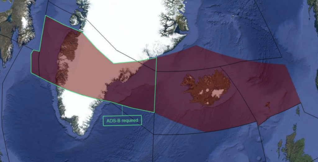
CPDLC in the US is FANS 1/A, as it is across the NAT HLA and even into the UK. But leave those green and frosty pastures for the European Mainland and you will find yourself in a land of ATN B1 fun.
It isn’t that fun actually because your FANS equipment won’t work, and there are also a lot of rules about who needs CPDLC and at what levels. You can read about it all here, and if you click on the map in the post (or here) then you will get transported straight to an implementation table which is very handy.
There is also a thing called a Logon List in Europe, which used to be called the White List, which you need to fill out in order to register to use CPDLC in Switzerland, Germany, and Maastricht-UAC.
The US has CPDLC but has not really mandated it. They are running trials on it though, which some BizAv aircraft might be able to join in on. We recommend reading this to find out more about that.
Flight Planning
In the US, the FAA has different codes and we aren’t sure when they will become codes for using in Europe too. So your flight plan filings might be a little different.
The codes mainly apply to new RNP type stuff and they go in Item 18 of your FPL.
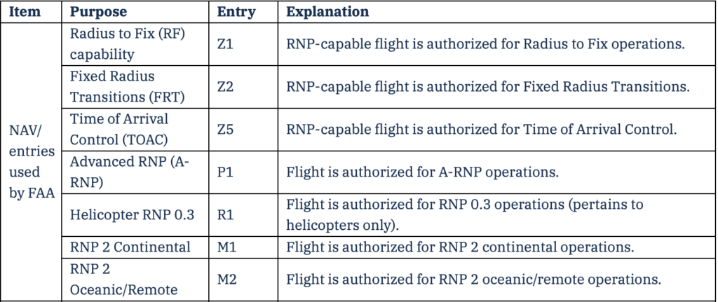
You can find all the codes in the FAA AIM Appendix 4 (click on the pic)
EU-LISA
No Comment.
Fine, EU-LISA
The currently delayed EU-LISA thing is sort of like the ESTA visa waiver stuff in the US. It is a system to allow for better monitoring and recording of people heading into Europe.
And that is all we are going say on it.
ADS-B
ADS-B privacy is a bit of a question anywhere, but in the US (in their territorial bit) you can sign up for certain stuff to make yourself less conspicuous – the LADD system, PIA etc. These won’t work in Europe.
Both the US and Europe have ADS-B mandates, although they apply at different levels.
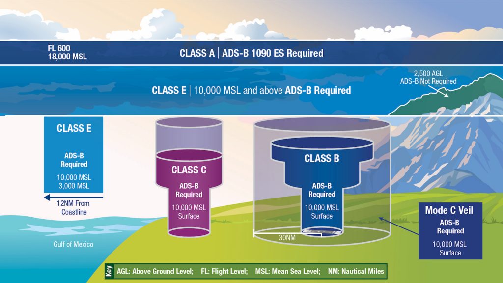
US ADS-B mandates
MAYDAY calls
That’s right, even these differ. Sort of.
In Europe you really need to say “MAYDAY, MAYDAY!” and when you do everyone still generally shush up, although ATC will start asking your intentions and trying to help you. You can tell them to standby if you want to.
In the US you might find you need to say “We are declaring an emergency” and might get a whole lot of questions straight after. They of course use ICAO calls (you can find the whole FAA info on that here) but occasionally (so we’re told) that this is something confirmed as well.
You can listen to an example here.
Europe also uses ‘Minimum Fuel’, which you should let ATC know about if you find yourself getting low on it (but are still fine so long as nothing else changes). They’ll help if they can, but will only properly be able to jump you in the queue if you call ‘Mayday Fuel’.
Strikes
I mean they have these both sides of the Atlantic, but they happen fairly regularly in Europe, particularly in France and Italy. If it is an airport workers type strike then your best point of call is going to be your local agent.
If it is an ATC strike then the Eurocontrol Network Operations Portal is going to have the info on it.
While we are talking about France and ATC, it is worth noting that they generally speak French here, especially at LFPG/Paris, and it can make things confusing at times.
Strikes tend to happen over major holidays so summer is a time to watch, Christmas and Easter coming in close second and third.
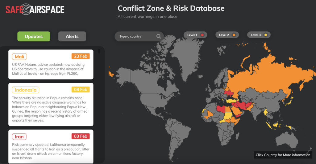
Airspace Issues
First up, Europe is the continent and the UK is still part of Europe. As, actually, is Russia and also Turkey, although since they border other continents they are often thought of as part of them.
EASA is the main authority for EU countries, which means the UK is not covered by them but by the UK CAA. So where you get your permits from is different. Emissions schemes are also separate.
Eurocontrol is the main airspace manager for want of a better title. Turkey and Ukraine are both member states, Israel and Morocco are sort of semi members. That doesn’t mean you are going to get the same level of ATC standards across them all though.
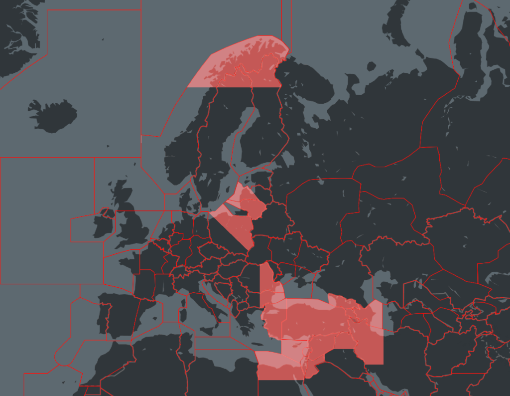
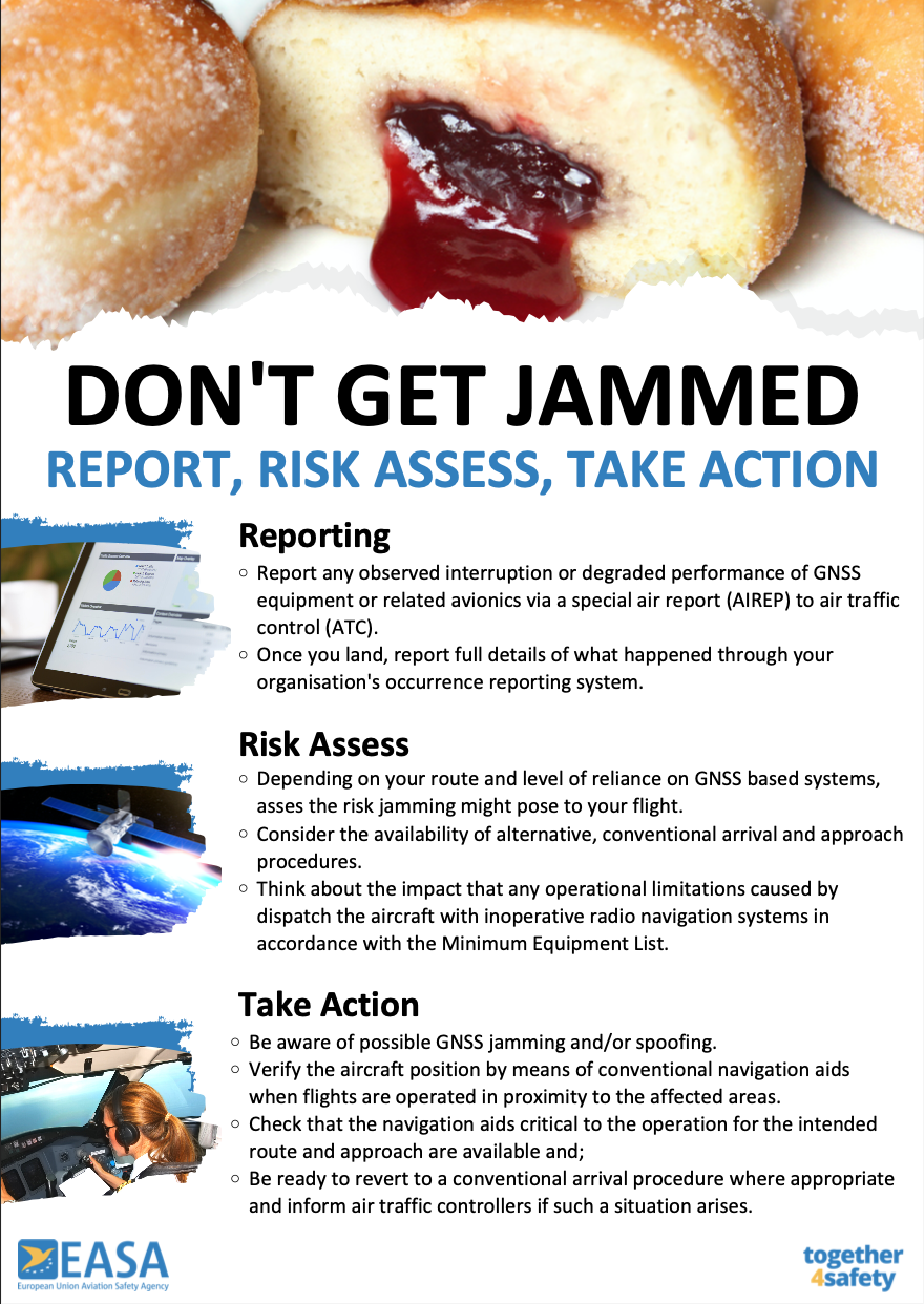
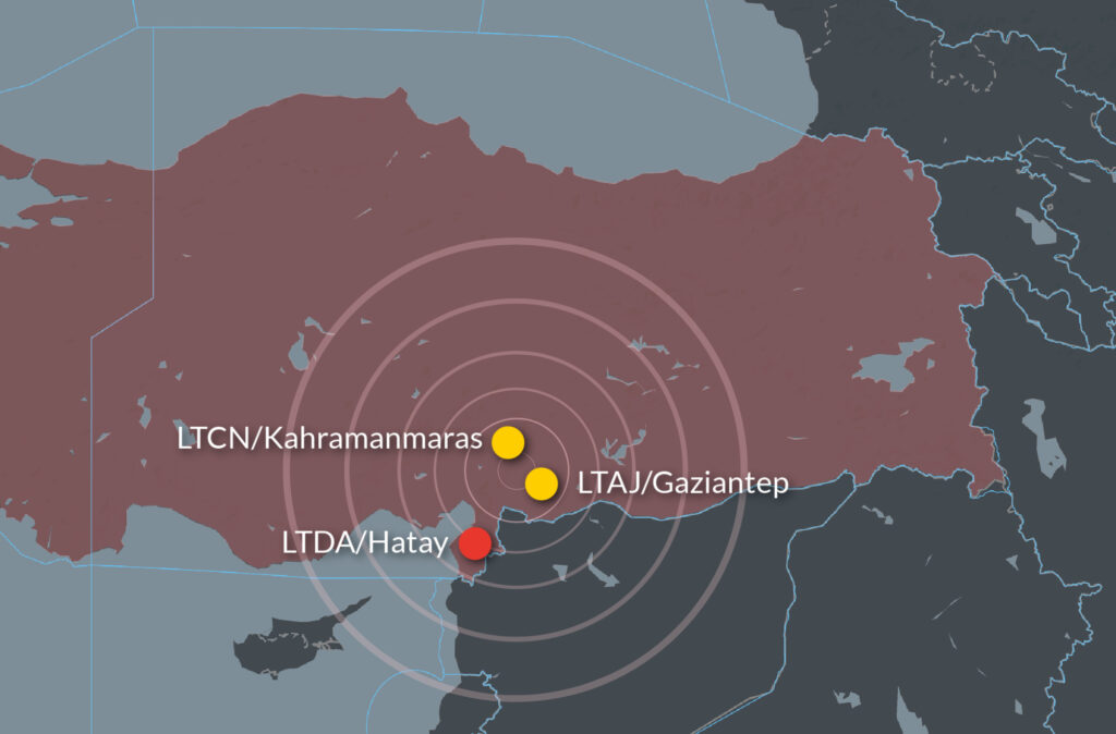
Turkey has a lot of issues with GPS jamming, and it borders certain countries with major conflicts meaning areas of the southern border and border with Iraq are not always risk free. They also have disputes with Greece over certain bits of airspace which is worth knowing about because it makes the communication and radio work more complex.
Ukraine’s airspace is currently closed due to the ongoing conflict with Russia. Moldova is mostly out of bounds. Poland has some safety concerns in the regions bordering Ukraine.
As far as we know, the US airspace is all considered fairly safe although there are some local procedures and airspaces to look out for – New York and the Florida metroplex area are two which spring to mind (although there are probably others? Let us know!).
Europe, because it is loads of countries not one big one, tends to see a fair old number of military airspaces activated so Notam and AIP SUP checks are important for info on those. Major military exercises in Europe are published through the NOP. The US of course has TFRs and other restricted and danger areas which are published here.
Ramp Checks (and MELs because they sort of fit into it as well)
Ramp Checks are rife in Europe. We recently received intel on the main issue items in French ramp checks, but these probably apply everywhere.
One big area of difference it the MEL vs MMEL thing. In Europe an MMEL is not usually accepted – they want an MEL specific for your aircraft. That said, there are some exemptions.
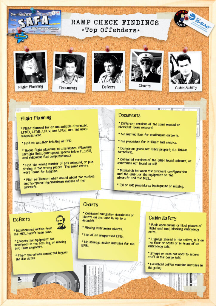
France’s ramp check ‘top offenders’.
General ‘vocab’
This might just be something only I struggle with, but I once had a humiliating experience flying into KIAD/Washington Dulles international where ATC asked if we “have Dulles insight?” I (pompously) informed him that no, we did not have ‘Dallas’ in sight, because we were heading for Washington.
Not used to being asked if visual, and not used to referring to airports by name got me good on that one.
And accents, ‘colloquialisms’ and of course actual differences in clearances can catch you out. There are differences in things like your arrival and descent clearances even.
In the US, in airports like KLAX/Los Angelas (an example I am familiar with) then often clear you (and there is a chance I am getting this wrong now) on the arrival which includes the descent clearance as per the arrival as well. I want to say “descend via” or maybe ‘cleared via’ (it’s a while since I’ve been there…)
Anyway, the clearance is for you to descend down to the lowest altitude on the arrival, but in Europe we don’t tend to do so without explicitly hearing the altitude.
Low Vis Stuff
OK, someone asked me to add this and I have to go get the old manuals out and look it up. In the meantime – watch out because we do stuff like RVR differently. And TERPS.
Fuel Tax, Curfews and other random things
Fuel tax is a thing in Europe, but also a thing you can attempt to claim back. In some places anyway.
A lot of European airports have curfews. It is worth knowing which countries have them so you don’t get caught out.

 Several airways off the coast will be impacted – primarily for those running north and south between the mainland US and Southern Mexico. Major ones include L207, L208, A766, A770, L214, and L333 impacting boundary waypoints IPSEV, DUTNA, KEHLI, IRDOV and PISAD between the KZHU/Houston Oceanic and MMFR/Mexico FIRs.
 Mission Accomplished


 So what’s changed there, and why is the FAA so concerned?


 Yes, we did take it way too far and realise that now.


 Risk for aviation


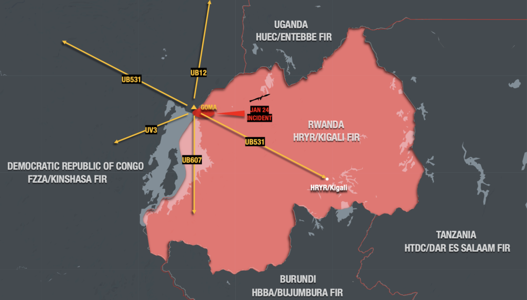 Also use caution on airways UM216, UA618 and UL442 away from Goma but which skirt the shared border where skirmishes have been occurring.