
There have been some changes to the boundaries of the datalink exempt airspace in the northern bit of the North Atlantic.
This used to extend down south to SAVRY, but now only goes as far as EMBOK.
So now you need datalink in the NAT oceanic airspace over Greenland controlled by Gander.
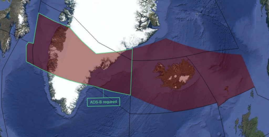
Here’s a pic of what that now looks like:
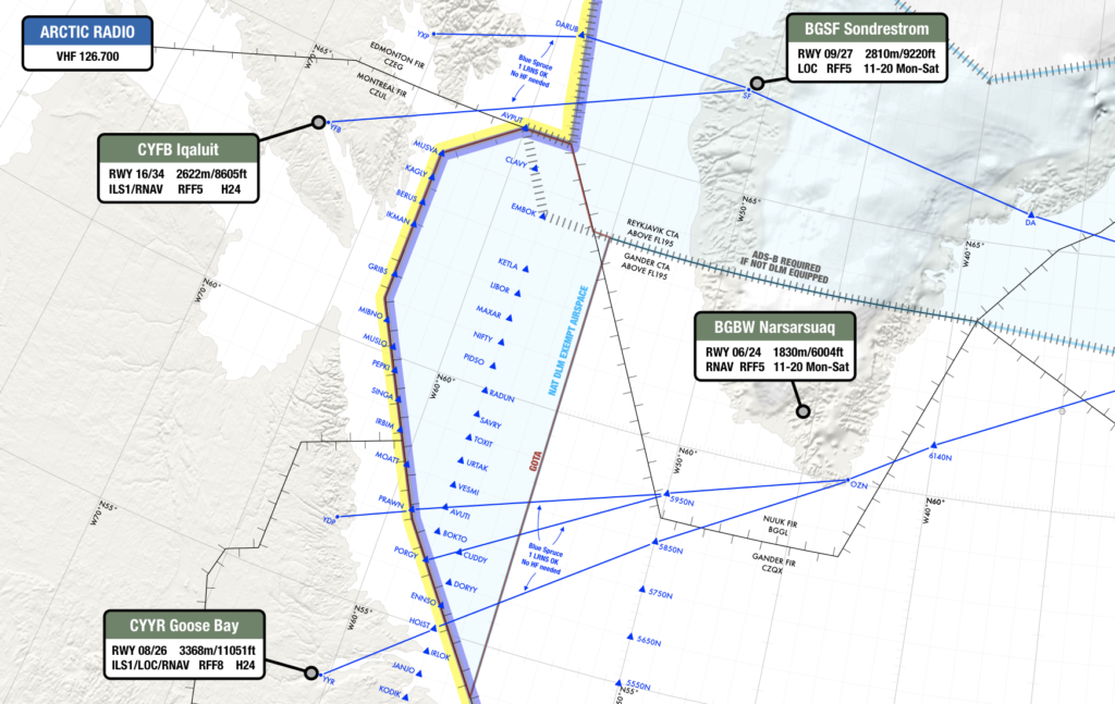
Datalink required in the white area east of GOTA and south of the Reykjavik CTA.
You don’t need datalink in GOTA airspace. We discovered this in Aug 2022, after some lengthy discussions with the authorities. (So that’s why GOTA is shaded blue!)
You don’t need datalink over the northern half of Greenland either, but if you don’t have it, you must have ADS-B (as per the grey hatched line in the pic above).
When did this change happen?
It was actually published in the updated NAT Doc 007 in Jan 2023, but we only just spotted it now!
The new coordinates are as follows:
Northern boundary: 65N000W – 67N010W – 69N020W – 68N030W – 67N040W – 69N050W – 69N060W – BOPUT.
Southern boundary: GUNPA (61N000W) – 61N007W – 6040N010W – RATSU (61N010W) – 61N020W – 63N030W – 6330N040W – 6330N050W – EMBOK.
Why has this happened?
At the end of 2022, Canada decommissioned some VHF and ground based ADS-B sites in southern Greenland, and therefore no longer have the datalink exempt area in the northern portion of Gander oceanic HLA airspace. So at that point, all Gander oceanic airspace became DLM airspace (although GOTA stayed datalink exempt).
The 127.9 frequency continues to be used by Gander IFSS for the Blue Spruce Routes.
So, to recap…
- Datalink Airspace: Remember, NAT DLM airspace only applies from FL290-410. Below or above that, you don’t need datalink in the North Atlantic.
- If you have full datalink (CPDLC and ADS-C): You can go where you like. But watch out here – “full datalink” means you have Inmarsat or Iridium. HF datalink alone (ACARS) does not meet the satcom part of the NAT DLM requirement. So if you want to fly in NAT DLM airspace (FL290-410 in the NAT region) “J2” in field 10a of your FPL isn’t enough – you need “J5” for Inmarsat or “J7” for Iridium.
- For GOTA airspace: You need a transponder, automatic pressure-altitude reporting equipment and VHF. If you have ADS-B, that’s helpful for ATC.
- For oceanic airspace over Greenland controlled by Gander: you need datalink.
- For the Blue Spruce Routes: You need datalink for the southerly ones, but not the northerly ones. (If you’re flying on these then you’re probably doing so below FL290 anyway, in which case you’re below NAT DLM airspace and don’t need datalink).
We’ve updated our dedicated NAT page with this info. This has a timeline of North Atlantic changes stretching back to the dawn of time (actually, 2015, but basically the same thing).
More on the topic:
- More: The North Atlantic Datalink Mandate – 2024 update
- More: NAT Conundrums Volume III: To GOTA and beyond!
More reading:
- Latest: Gander’s Bringing Back CPDLC Oceanic Reroutes
- Latest: EU Temporary Admission of Aircraft – Busting Myths
- Latest: US Ops Update: Speeds, Squawks and Slippery Runways
- Safe Airspace: Risk Database
- Weekly Ops Bulletin: Subscribe
- Membership plans: Why join OPSGROUP?


If one has a diversity transponder setup – so broadcasting up to the satellites as well as down to the ground, why would they move the DLM line further north just because ground based ADS-B stations were decommissioned? That was the whole point of diversity transponder setups?