This article is from Karlene Petitt – international airline pilot, author, and speaker. It occurred to us that we hadn’t talked much about pilot mental health and wellbeing here on the OPSGROUP blog, and we wanted to change that. We know that pilots not being able to talk openly about mental health struggles for fear of being grounded is the big problem that needs fixing. But for now, we wanted to start at the individual level, with these questions: How can we help people right now? What can pilots do if they feel they have limited control of their environment? Over to Karlene for some answers…
As a pilot I have spent years navigating storms around the globe. Not a difficult task because technology enabled me to identify the strength and location of those systems—I could see what was ahead and avoid them. However, every so often we would get pounded by clear air turbulence. In those unexpected situations, there was no time to do anything but grab the controls and deal with the issue at hand. When the unexpected happens, pilots deal with it quite effectively because we are trained to fly the plane and then solve the problem. The stress of an emergency doesn’t immobilize us – we learn from it and carry that experience forward.
From my experience, flying airplanes is easier than navigating life. As humans we are not issued radar equipment; few, if any, read their systems manual; there are no standard operating procedures; and most of us don’t receive training as how to deal with life’s unexpected surprises that pile up. How do you deal with unethical management, dysfunctional operations, irritating co-workers, fear of reporting safety concerns, extreme work environments, or even harassment? Throw in a mortgage, toddlers to teens, tuition, increasing life expenses, relationship issues, or even a neighbor’s barking dog.
How often have we laid awake thinking about stuff? Perhaps your mind even wanders to someone who harmed you in the past. An attorney told me that he knew he had everything that should bring him joy, a great job, great wife, great kid; yet daily happiness eluded him until he reached to anti-depressants to make his world a better place. At least when we have life problems, we can justify the reason for unhappiness. But what if there is no apparent reason? What if the unhappiness is simply that you are working in an environment that opposes your values and you justify that behavior or look the other way?
I was told that people do not want to be told to drink less, read a book, and do yoga to solve their problems. While I love reading, I often do it with a bourbon in the tub, as I contemplate joining a yoga class. I get it. Instead, I recently joined a group who was inspired by a post I had written on pilot suicide. The group’s title: How to talk to pilots, turned out to be verbal vomit filled with big words, theory, and discussion of all the problems within corporations, but no solutions were offered.
I then reached for one of the first books I’d written, Flight to Success, Be the Captain of Your Life, and opened it to a quote, “Happy is right here, right now, living the journey.” A prolific statement, but how do we achieve that feeling? Is happiness a feeling, a way of life, or how we think? My answer – yes to all.
The question is how to get there? A good counselor can help with that journey. But when I recently said to an integrative medicine doctor, “Do you know how hard it is to find a good counselor?” He emphatically said, “Yes I do!” Even those helping others need help too. We all do.
Unfortunately, as a pilot, as in many other professions, mental health counseling places you in the “danger category” to the public and therefore must be reported to officials, placing your career at risk, and thus keeping many people away from getting assistance to balance their life. This archaic thought is ridiculous at best and prevents people from getting the help they need. Far too many pilots and military personnel have taken their lives after years of personal issues that snowballed. Problems addressed early prevent them from being perceived as hopeless.
We all know the first step is to identify the problem before you can solve it. Anyone who has the foresight to seek help for themselves before life problems become insurmountable has a strong mind, not the other way around. But that is not where we are in society today. Which is extremely frustrating because our world is in a substantially chaotic mess, a time when we could use help more than ever.
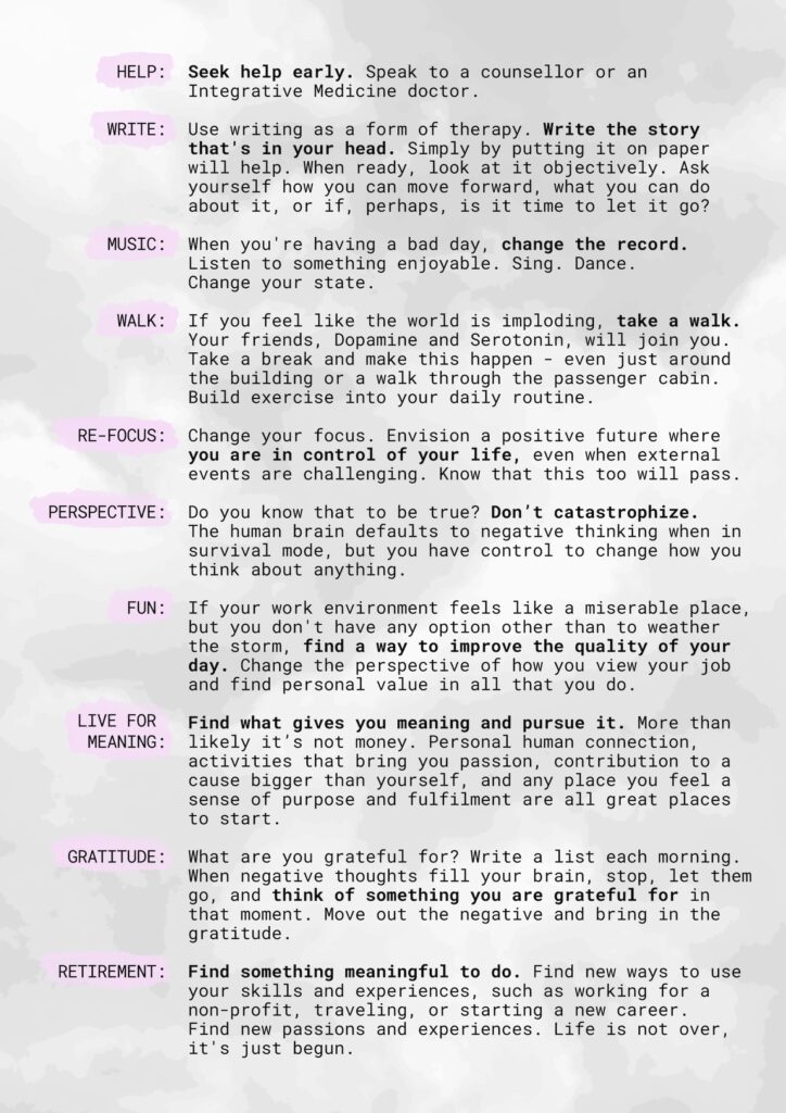
What To Do
Take my words for what it’s worth because I have been through hell and back multiple times in my life, and I’m still figuring it out. But along the way, I have learned a few things and today they are all coming together like a jigsaw puzzle. I am happy. Not to be confused with moments of being pissed off. Yes, you can be happy and get angry too. No… you are not bipolar.
I am the middle of five daughters from a broken home at the age of nine. I became an airline pilot despite my entire formative years being told that girls couldn’t fly. Growing up, I babysat, mowed lawns, bagged groceries, and bussed tables. My airline career was another story. Furloughed. Bankrupt. Merged. I started over eight times. Despite women not being able to fly, I earned eight type ratings and became an instructor. I raised three daughters, and during my journey I earned a Master’s in Human Services, an MBA, and subsequently a PhD. My survival skills pattern was to attend college and learn more to address life problems of the time. Not always my own, but that of our aviation industry as well. Hundreds of books have found their way into my home.
This overachieving goal-setting behavior would later haunt me when my airline paid a doctor $74,000 to state I was bipolar after I gave them a 45-page safety report. What should have been my golden years of flying, I ended up in the middle of a seven-year nightmare of litigation. Not until November of 2022 when the airline finally threw in the towel after having lost in trial and on appeal, offering me a settlement of what the judge originally ordered, did my health finally turn for the worse. I was done with the hard part. I won. It was over. But my physical body gave up.
I suspected my health decline was due to my frame of reference and how I perceived that settlement. In January 2023 I lost my first class medical. Then on January 31st I retired, leaving the last 4.5 years of my career behind. I did not medically retire. I walked away from this airline to heal my life and subsequently myself.
I’m not going to tell you to drink less, but I will share with you what I learned in the process of restoring my health. I won’t ask you to read a book, but I will share principles I learned from books I’ve read, through my education and from experience. Not theory, but practical application. Below is a litany of suggestions, and I offer you to take what works for you.
Journaling
Challenging my bipolar diagnosis, Dr. Trenerry at the Mayo Clinic had asked me what I had been doing during my time off, due to my composure before him. He said, “Most people would be an absolute wreck having gone through what you have.” I told him I was writing novels. He asked if I was in those books, and I said, “Yes,” and then explained a scene in Flight for Truth, where one character (me) told the other character (also me), “They might very well get away with this, but your life will not be over. It will just be different.” He said with a smile, “Keep writing.”
I had to convince myself that no matter what happened in my life, it would not be over – just different. Life doesn’t often go as we planned, but the acceptance of doing all you can do, and then accepting the reality is the only way to move forward. As it’s been said, if you want to make God laugh tell him your plans. Most experts say that journaling is one of the best things to do when dealing with a life issue. Unbeknownst to me, I simply took journaling to the next level by writing novels—truth in fiction.
Quill, parchment, and drawing room are not essential.
Writing works. Perhaps your life, too, can be a story. As Stephen King said, “Write for the garbage can.” Do not edit. Do not re-read. Just put your story onto paper, and one day you’ll have a book. That’s what I did. Polishing will come later. But there is something freeing to place all the thoughts you have running around your head onto paper. You free yourself from thinking about them. There will be a time to revisit the situation later.
If you cannot tell your problems to a psychiatrist, you can tell them to the computer. If you want to have a little fun, after you’ve written a passage, play counselor and type these words: What do you think about that? What can you do about that? What does that mean to you? Is there a better way to look at this situation? Then answer those questions. You’ve just participated in a form of self-directed therapy, and you do not have to report it to the FAA or any controlling agency.
Music
It’s harder to be sad when uplifting music is playing. When you’re having a bad day, change the record. Shift your emotion from thinking about what’s happening, to listening to something enjoyable. Sing. Dance. The more emotion and physical movement you put into it, the more you will smile and shift your energy to a positive a frame of thinking.
One day I had sat down to read a legal motion that the airline’s attorney had written. The more I read, the angrier I became at their false assertions. I stopped reading, plugged into some good music, and went outside and mowed my lawn. I found myself dancing while I mowed. This didn’t make the legal motion go away, but it just changed my attitude, changed my feelings, and enabled me to better address the issue.
Take a Walk
I’m not going to tell you to exercise. I am going to tell you that the process of exercising enables your body to naturally increase your happy brain chemicals called dopamine and serotonin. These are the drugs psychiatrists prescribe for depressed patients, but without the negative side-effects. When you exercise, you simply feel better.
Just watch out for puddles.
If you feel like the world is imploding, take a walk. My current routine is to awaken, drink water with Zip Fiz on the elliptical or bike, even before I have coffee, while listening to fun music. My day is much more productive this way. I have also passed many type-rating programs studying during my morning exercise routine, while listening to music. In the middle of the day, break away and get moving… even if it’s a powerwalk around the building or through the passenger cabin.
Stress Management
Not all stress is bad, it simply gets blamed for everything. There is good stress that engages, provides experience, improves resilience, and enables us to grow. It’s the bad stress that I speak of today. I recently learned of a Stress Management and Resiliency Training (SMART) program from the Mayo Clinic. Not unlike Marci Shimoff’s, Happy for No Reason, Dr. Seligman’s Authentic Happiness, or The Rabbit Effect by Dr. Harding, research supports that the events in our life are not what cause us problems, it’s how we perceive those events.
Do you perceive the event in your life as a transient issue, or that your life will always be like this? Do you believe that you have control over your world, or does your world control you? Do you believe there is a way out, or do you believe your situation is hopeless?
I can state with absolute certainty that your life will not always look like this. You absolutely have control over your life, despite external events trying to exert their existence. There is always a way out. Nothing is hopeless. Seeing a positive future is powerful. If you cannot see it yourself, that’s when you need to get help to paint that picture for you. My sister was taking a course during nursing school and the instructor asked the students to envision the life they had now, and what that will look like ten years in the future. She saw the way her life was headed, cried, and then changed it. You, too, have that power.
Do You Know That To Be True?
How often do we place judgement as to the actions of another? How often do we think the worst? For example, you receive a note from your boss, “see me after work”. Who would not spend their day catastrophizing thinking the worst case possible? We all create mental images filling in the pieces because the human psyche needs to have answers. Marci’s suggestion in Happy for No Reason, is that when you find your brain going down that path to stop and ask yourself, “Do you know that to be true?” Most often we do not. So don’t allow your thoughts to go there. This question stops negative thoughts from taking hold. “How” we think about things causes most of our life issues.
Negative thinking could be construed as a human condition because our brains tend to default to survival mode. Some refer to this as the reptile brain. At the beginning of time when we were faced with predators and finding food and shelter where a priority for survival, this default condition was necessary.

We’ve all been there.
But we no longer need those same survival skills because we don’t have the same threats in our external world. Thus, the mind defaults to survival from threats within and will create a threat that is not there. We ruminate, worry, and catastrophize. We think about how someone harmed us, we regret what we did, we bemoan what we should have done, and we fear what the future might look like. The trick is training your mind to not go there and convincing it to travel down a different path.
When you assume something, ask yourself, “Do you know that to be true?” While exercise, listening to music, and meditating will help with stress management, it is imperative to train your mind to be focused, preventing it from wandering through a minefield. When a negative thought pops in, let it go and replace it with something you are grateful for. Create a practice of gratitude to replace your negative thoughts.
Create Enjoyment
In that we spend much of our waking hours at work, if we don’t find value, enjoyment or gratitude in our work, our health will suffer and negatively impact our life in many ways. Unless you are a manager or executive, you have no control over the external work environment. But you do have control of how you deal with that environment. If your work feels like a miserable place and you don’t have any option other than to weather the storm, find a way to improve the quality of your work environment. Sometimes that is as simple as changing how you perceive your job, and how you see your personal value in what you bring to your work.
When Covid hit, flight crews flew long days and then were isolated with 24-hour layovers locked in a room. Socialization dropped to nothing, which for many the layover was the best part of the job. This impacted the mental health of many people. Isolation in general from Covid did that to much of society. With socializing at the end of a flight gone, I made an effort to stand at the boarding door and talk with the passengers as I gave wings to the kids before I was locked into the flight deck. I made an effort to engage where I could.

Don’t be this guy.
Layovers were tough for most. I once had a 72-hour layover locked in my room in Korea. Instead of complaining I soaked in the tub, watched movies, I ordered room service, wrote, and caught up on emails. What was perceived as torture to many crews would be a vacation to any stay-at-home mom. I opted to turn my situation into a hotel staycation. Perspective. Change your perspective on any negative situation and you will improve the quality of your life.
Money and Happiness
Depending upon the research, the country, or the participants surveyed, you will find a variety of statistics on whether money can buy happiness. Dr. Harding asserts that once we have enough money to provide shelter, food, and proper medical care that the additional income doesn’t improve the level of happiness. This assertion could be supported by those rich and famous who take their own lives despite apparently having it all. If your value is truly amassing a fortune for the sake of having money, then perhaps more money could bring happiness. However, if you think that more money brings happiness because of the stuff you can buy, the reality is that stuff doesn’t bring you happiness. Happiness comes from gratification.
Job Loss and Gratification
If the job is miserable and you cannot change your perspective or find value in your work, the question is not necessarily can you afford to quit… but can you afford not to? That will be a personal choice. But what if you are forced to leave due to a mandatory retirement age or a layoff, how do you deal with that?
Retirement should bring happiness, but far too often it does not. The stuff we buy might bring a moment of pleasure, some think it makes you happy, but the feeling is fleeting. For true happiness we need to feel gratification. Take a pilot who is forced to retired. This person was highly trained and used their skills daily to accomplish the goal of a flight. They spent a couple hours of preparation to depart, and then spent hours enroute either engaged in conversation with their fellow pilot, reading a book, or appreciating the beauty outside their flight deck, followed by a skilled landing… it was a journey. On the layover, they shared dinner with coworkers, had a beer and much laughter. While there was often bad weather, fatigue, and all the issues that could make the day more challenging, those issues improved gratification of a job well done.
Now, imagine this highly trained individual being told they can no longer do their job because someone said they are too old, or the company sold out and their services are no longer needed. They may have saved wisely and could buy stuff to make them feel happy, but they don’t feel it. There is a hole because stuff doesn’t make you happy.
Anyone who works in an extremely gratifying, highly skilled, job will have the most difficult time in leaving their employment. The solution is to find something meaningful in your life. The happiest retired pilots I know have either found another flying job, purchased a camper and are traveling, golfing, working at a non-profit and giving back, or have gone back to school to begin another career.

The Solution
If I could impart any wisdom, it would be to change how you perceive your world. Create habits of listening to music, exercising, journaling, adopting a different perspective, or meditating, to improve how you feel. Change your perspective on the word “mental health” and simply think of these suggestions as activities to feel the daily joy you deserve. Your physical health will follow. What that looks like, will be specific to you. For me, my morning habits simply make me feel better. I’m doing something for me, before I give my day to everyone else. There is a reason we tell passengers to put on their oxygen mask first before they help others. I also know that I love learning, creating, writing, and helping others. Figure out what you love to do, what pulls you into a flow, and then create a life around those activities. Habits create the tapestry of life in the fabric of existence. They will either lift you high or hold you down. The choice of which is yours.
Click to download PDF.
Q&A
Here’s the bit where Dave from Opsgroup asks some questions, and Karlene gives some answers.
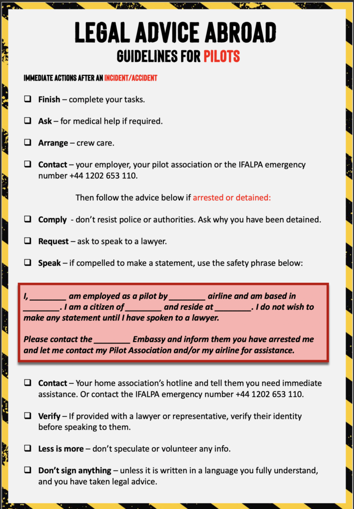
1. If we need help as pilots, where can we go? What are some of the resources out there available to us?
Trust but verify. Your AME is an excellent resource; however, like any profession, there are some AME’s that are better than others. Some will be your advocate, while others play it safe and not necessarily to your benefit. Find an AME that has your back, and someone you can be completely honest with. Then, despite all the advice you receive, visit the FAA.gov website yourself, and type your questions into the search box and educate yourself on the rules and regulations.
If you choose not to see a counselor or psychiatrist because of an archaic FAA reporting requirement, I suggest seeing an Integrative Medicine Doctor. These doctors are not counselors and not psychiatrists. The integrative medicine doctor I saw at the Mayo Clinic was an MD. Integrative medicine is an evidence-based approach to improve your health and wellness, through physical, mental, emotional, and spiritual impact on your health. You can list this doctor as an MD, and the reason you are seeing him/her is for your overall health and wellness. But they are an excellent source to help deal with life issues.
2. What questions can we ask each other to check how we’re doing?
Pilots are not trained to assess each other. There is no magic pill. No specific question to ask. With respect to the most recent pilot suicide at my airline, nobody would have known he was ready to leave this earth. Sometimes you just can’t tell. But what we can do is listen and listen for comments of hopelessness. If you think it’s more than just a bad day, encourage them to speak to someone.
Anything we missed?
If you have questions about any of the above, or if you think there’s something we missed, let us know!
About the author:
Karlene Petitt. PHD. MBA. MHS. Type rated on A350, A330, B777, B747-400, B747-200, B757, B767, B737, B727. International Airline Pilot / Author / Speaker. Dedicated to giving the gift of wings to anyone following their dreams. Supporting Aviation Safety through training, writing, and inspiration. Fighting for Aviation Safety and Airline Employee Advocacy. Safety Culture and SMS change agent.
Are you someone with knowledge to share?
Know something about something worth knowing? Want to write about it? Let OPSGROUP know! Maybe we can work together and write an article on it.


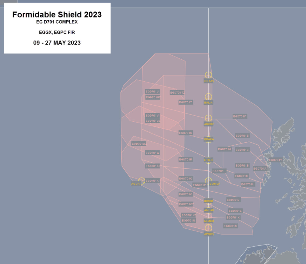
 Eurocontrol are going to be working hard to re-route flights – around 800 flights each day, with around 300 of these expected to have at least 60nm added to their routings. They predicted the average delay per flight would be around only 3 minutes (but we have to say that feels extremely optimistic!)


 There were three major hazard areas – portions of the Yellow Sea, East China Sea and the Philippine Sea.
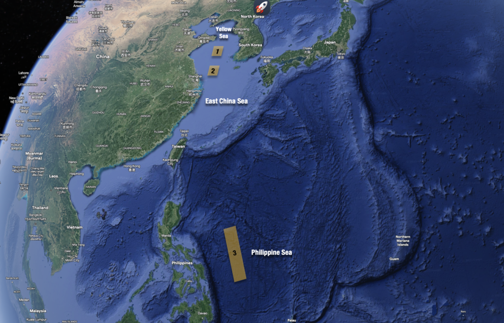 The official advice was avoid them completely, if practical. Otherwise, to listen out to ATC for potential updates.


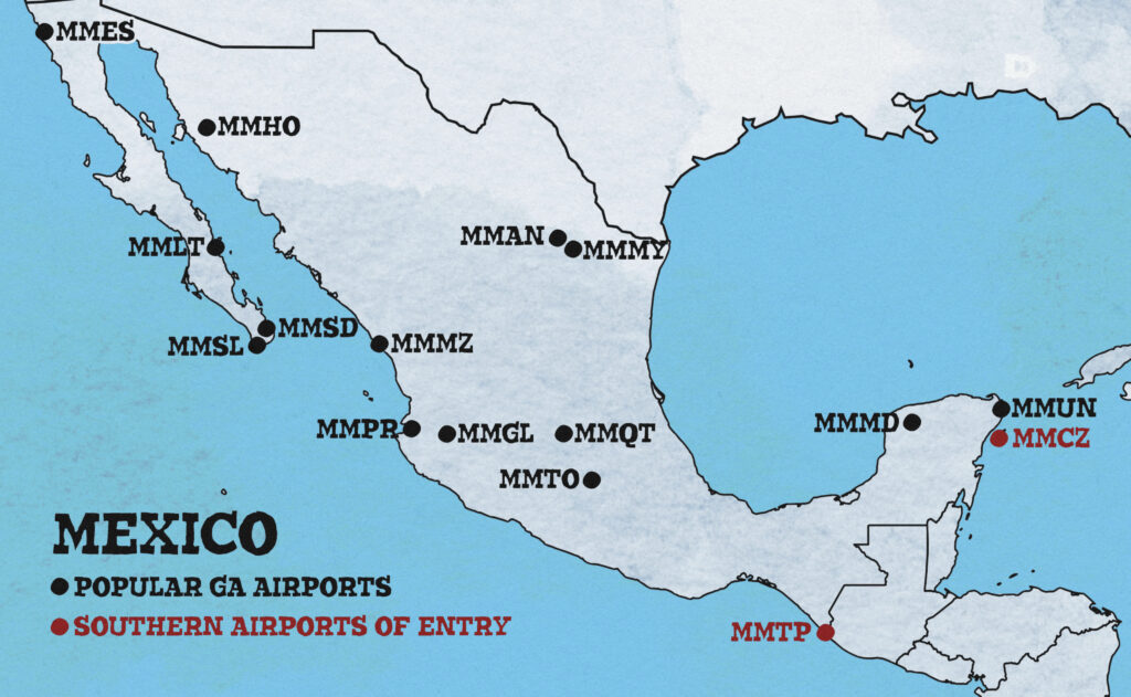
 Several airways off the coast will be impacted – primarily for those running north and south between the mainland US and Southern Mexico. Major ones include L207, L208, A766, A770, L214, and L333 impacting boundary waypoints IPSEV, DUTNA, KEHLI, IRDOV and PISAD between the KZHU/Houston Oceanic and MMFR/Mexico FIRs.
 Mission Accomplished