Eastern Pacific: Navigating NO FIR Airspace

Key Points
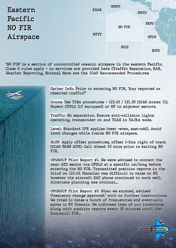
  • ‘NO FIR’ is a section of uncontrolled oceanic airspace in the eastern Pacific.
  • Class G rules apply – no services are provided here (Traffic Separation, SAR, Weather Reporting, Notams).
  • There are some ICAO Recommended Procedures: Contact ATC, use TIBA Procedures, turn on all lights, keep squawking, SLOP, and fly standard levels.
  • Download the OPSICLE below for a summary of the procedures.

OPSGROUP Members: Click to download PDF.

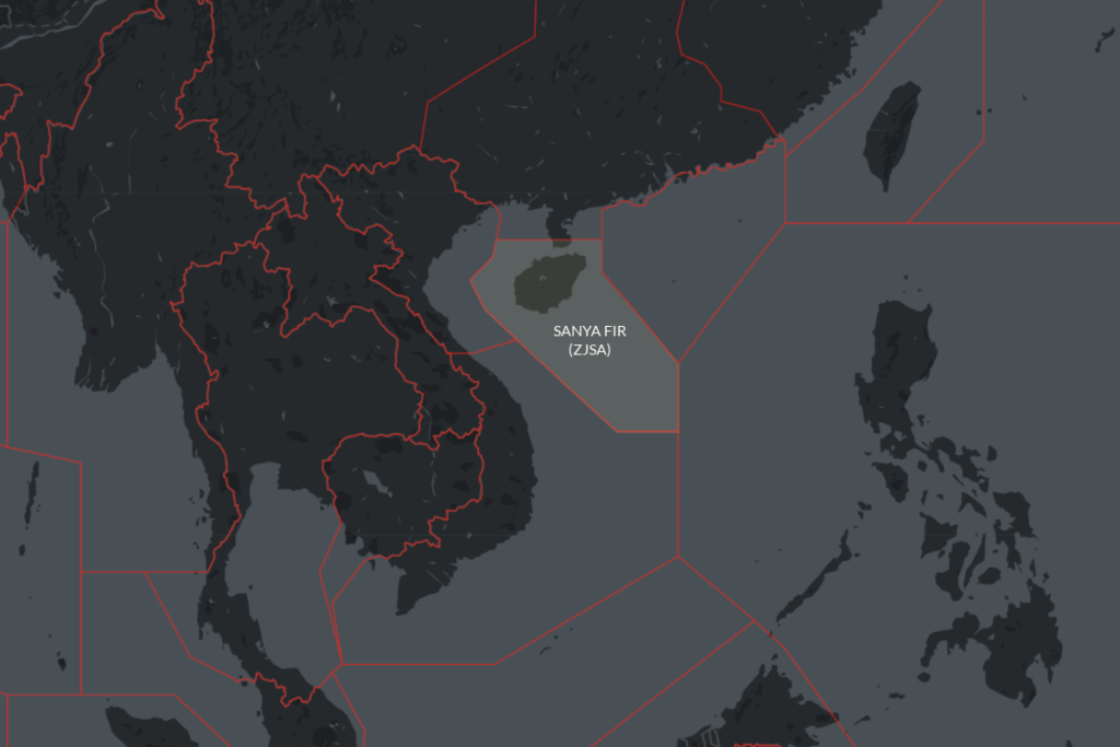
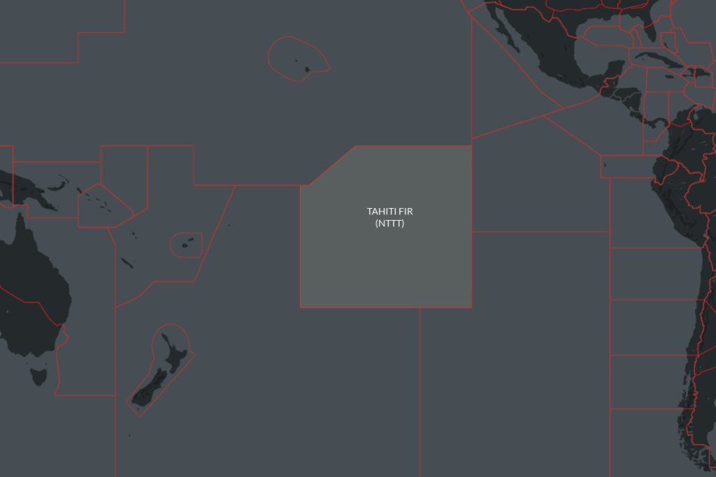
‘NO FIR’ at the edge of the world

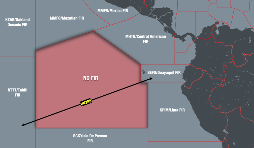
Well off the coast of Peru in the Eastern Pacific sits a large chunk of oceanic airspace known simply as ‘NO FIR.’ As the name suggests – it is completely unassigned. No ATC agency is responsible for it.

You may not have heard of it, because in almost all cases operators simply avoid it. There are just no procedures out there. And when attempting to find some, more questions are raised than answered.

The problem is that avoidance is beginning to cost time and money. With the establishment of ultra-long-haul routes, and aircraft capable of flying them, fuel is becoming increasingly critical. Especially when you consider that in some case ETOPS certification has now reached a whopping 370 minutes – that’s six hours.

And so OPSGROUP is often asked – how exactly can we operate directly across it? We didn’t know either, so we reached out to ICAO for some answers.

Where can I find the procedures?

This may come as a surprise, but there are none. Because no state is responsible for the NO FIR airspace (yet), there is no AIP to reference.

Until ICAO can successfully delegate this laborious task to adjacent countries, the standard ‘rules of the road’ apply – and none of them are specific to this particular piece of the high seas.

There is some provisional guidance out there, but it is just that – provisional. It is based on a 2019 project to subdivide the NO FIR airspace into pieces managed by Peru, Ecuador, Tahiti and the COCESNA states. This has yet to happen, and was stalled by Covid. ICAO advise the project has been revised but will take more time to implement. Until then, no one is home.

Best practice

So, how do we cross the NO FIR airspace without procedures? We need to rely on best practices instead. Here is what ICAO suggested to OPSGROUP, and it begins with a caution:

No one is responsible for it. It is important to understand the impact of this. There will be no traffic separation, SAR services, weather forecasting or even Notams. You will also need to make sure your insurer is happy for you to traverse this kind of airspace.

There’s a lot of ocean out there – careful contingency planning is needed to mitigate the risks of crossing NO FIR airspace.

Having made the decision to enter however, ICAO recommends the following:

  • Use the information available to you. Before you enter the NO FIR airspace, ask controlling ATC the following question (keeping in mind that English may not be their first language)…
    “Is there any known, or observed traffic?”
    It is possible they’re aware of preceding traffic ahead, or are expecting some to exit. Even partial info, is better than none at all.
  • Use TIBA procedures. Yes, they’re technically for ‘contingencies,’ but the principle remains the same – hear and be heard. You can find those procedures in ICAO Annex 11. What frequency? There isn’t one published for the NO FIR airspace and so ICAO suggests using chat (123.45) or guard (121.5).
  • Be Seen. Turn on all anti-collision and navigation lights, just in case.
  • Keep Squawking. Use your transponder and TCAS TA/RA function at all times.
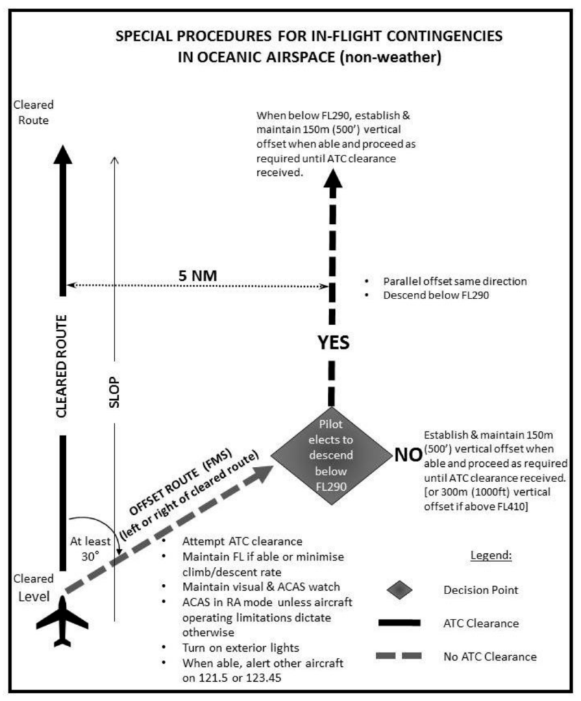
  • SLOP. Follow Strategic Lateral Offset Procedures to further separate you from oncoming traffic. In other words, intentionally deviate up to 2nm right of your airway. You can find those procedures in ICAO PANS ATM, or ICAO Circular 354.
  • Fly Standard Levels. Stick to even levels heading west, and odd levels heading east. Also avoid changing levels inside the uncontrolled airspace unless it is dangerous not to do so.
  • Call Ahead. At least ten minutes before exiting the NO FIR airspace, call ahead and give the next ATC sector a head’s up you’re coming.

What not to do

Rely on adjacent agencies to take care of you anyway.

The most common misconception out there seems to be that the KZAK/Oakland Oceanic FIR will provide some emergency assistance via CPDLC.

When we reached out to them directly they advised this may be the case for some aircraft transiting the adjacent MMFO/Mazatlan FIR, but this is not the case for the NO FIR airspace – as far as they are concerned, there is no log-on available or any other services available.

Operator reports

So that’s what written on the back of the packet, but what about intel from pilots who have recently flown through it? OPSGROUP reached out to members, and received these reports on what to expect:

OPSGROUP Member: …we were advised to contact the next ATC sector via CPDLC at a specific lat/long before entering the NO FIR. We transmitted position reports in the blind on 123.45. Mazatlan was very difficult to raise on HF, however the aircraft SAT phone continued to work well. Alternate planning was critical. We flew through in day visual conditions, and so weather was easy to see and avoid…

OPSGROUP Member: …when we entered, we were simply told ‘frequency change approved,’ with no further instructions. We tried to raise a bunch of frequencies and eventually got in touch with NY Oceanic (randomly). We just informed them of our intentions along with position reports every 30 minutes until we entered the Guayaquil FIR. I’ve never been able to find further instructions on how to operate in this airspace…

There is no magic bullet

The Pacific’s NO FIR airspace is useable but with careful consideration. The challenges of crossing it can be mitigated, but only with solid contingencies in place.

ICAO’s guidance above is a solid starting point, however it is up to individual operators to decide whether the commercial reward outweighs the potential risks.


Global Campaign on NOTAM Improvement

Update: The NOTAM campaign was launched with 1,500 attendees on April 8th – and yes, it was the largest virtual event in ICAO history! The first update webinar on progress being made is on June 16th at 1200Z – register with this link, and join the call.


The Global Campaign on NOTAM Improvement is being launched on April 8th, 2021. Spearheaded by ICAO, and supported by OPSGROUP, IFAIMA, and IFALPA, the campaign will focus on making significant improvements to the NOTAM system to enhance its effectiveness, usefulness, and reliability as a mechanism for pilots to receive critical flight information.


Kick-Off Webinar, April 8th 2021

At 1200Z on April 8th, 2021, we will launch the campaign with a worldwide webinar. So far, we have 600 registered participants. We are on track to make this the biggest virtual event in the history of ICAO. If you think about it, that’s pretty amazing for a meeting about NOTAM’s!

This webinar is open to everyone, and we would be delighted to have you join it – to show your support for the Notam Improvement campaign, to learn more about what the plans are, get the latest update, and see how you can get involved: this is a collaborative, shared mission that needs your help, whether you are a pilot, dispatcher, AIS officer, software developer, Flight Planning provider, ANSP, CAA, or are in any other way a user or provider of some aspect of the Notam system.

So, please join us – it’s open to all:
Register for the Worldwide Webinar on Thursday, April 8th, 2021 – 1200 UTC

1200 UTC = 7am Lima, 8am New York, 1pm London, 2pm Berlin, 4pm Dubai, 7pm Bangkok, 10pm Sydney, 12am Auckland.


Why should I join the Webinar?

Over the last few years, as many as 10,000 pilots and dispatchers have supported a move to fix Notams – through petitions, surveys, comments, emails, and joining the OPSGROUP Notam Team to help fix the problem. Your voice has been heard: this work is the result. Now, we need your support for this campaign – to reinforce the message that as an industry, we really care about this. Your presence will encourage those working on solving the Notam Problem, and you will get the full picture of where we stand in the progress to fix things.

We will speak about the mission, demonstrate the problem with some real world examples of pre-flight briefings, showing how these impact the daily lives of pilots and dispatchers, clarify the definition of “Old NOTAM’s”, and show how AIS staff can use the existing regulatory framework in Annex 15 and Doc 8126 to become a gatekeeper for NOTAM quality, demonstrate the Notameter, address regional challenges, and have a Q&A session.

Our presenters and speakers will include Stephen Creamer (Director of the Air Navigation Bureau at ICAO), Alex Pufahl (ICAO Technical Officer), Mark Zee from OPSGROUP, Capt. Lauri Soini from IFALPA, Fernando Lopes and Antonio Locandro from IFAIMA, Marco Merens from ICAO, and ICAO Regional Officers.


What is the Notam Campaign all about?

First, the problem: Pre-Flight NOTAM Briefing packages are often far too big to be fully read and understood by pilots before a flight. The result: critical information is missed. Finding safe ways to decrease that volume is the key focus of this campaign.

In the Global Campaign on Notam Improvement, our aim is to solve the Notam Problem in manageable chunks, gathering energy as we solve them and make progress. Rather than re-invent the wheel, we will fix the system from within, starting with the easier aspects and progressing from there. The first phase of this campaign focuses on Old Notams. At any one time, there are about 35,000 active Notams globally, and 20% of these – one in five – are old; in other words, not respecting the existing rules of Notams being issued in principle once only for a maximum of three months (everything else should go into the AIP, an AIC, or some other publication).

We are drawing on the collective cooperation of the AIS community – the Notam Officers – to uphold the rules and get rid of Notams that don’t follow them. The result will be a potential decrease of 7,000 Notams per month, and a 20% reduction in the size of the average briefing packet. For more on the Notam Problem itself, have a look at “Why pilots are reading a Reel of Telegrams in the Cockpit“.


Who is behind it?

The Global Campaign is a meeting of minds, agreeing on one thing: Notams need fixing.

ICAO is spearheading the campaign, in the recognition that the Notam Problem is a worldwide issue that affects flight operations in every country.

Providing support, energy, and huge enthusiasm to help solve things are IFAIMA, representing the Aeronautical Information community, IFALPA, voicing the concern of Airline Pilots, and OPSGROUP, whose pilot, dispatcher, and flight operations members have been tirelessly involved in the mission to fix Notams since 2017.


What can you do to help?

Thank you for asking! If you are in the AIS community – perhaps as a Notam Officer, AIS Officer, Publisher, or Promulgator – please tell your colleagues, join the webinar, and get involved in this Campaign. If you are a Pilot or Dispatcher, join the webinar, share the news of this campaign (#NOTAM2021), voice your support, and monitor progress – we’ll want your help down the track as well. If you are a Flight Planning Provider or Software Developer – again, join the webinar, and when the time comes, get involved in the collaboration around technical improvements. If you work for an ANSP or Civil Aviation Authority – join the webinar, encourage your colleagues to join too, and help support the Campaign. If you work for an Organziation, tell your members, and share news of this campaign (#NOTAM2021). Oh, and join the webinar!


How we got here …

This is a Global Campaign for a very good reason. We only solve this problem when we solve it for all countries – so we take the lessons learned domestically from those countries that have seen NOTAM wins, and amplify that across the rest of the globe.

In terms of change so far, most notable is the work done by the AIS Reform Coalition in the United States, chaired by Heidi Williams from the NBAA. This group of people from NATCA, ALPA, AOPA, IATA, A4A, ACI, the NBAA and others have been working feverishly in partnership with the FAA to drive change and improvement. And it has had remarkable results – the US has radically improved NOTAMs in the last 2 years: NTAP gone, a big reduction in PERM Notams, a single office for AIS, a transition to the FNS, and NOTAM Search replacing Pilot Web. Canada has transitioned to ICAO format for Notams, and provided a new delivery mechanism through CFPS.

We must also recognise huge efforts from the members of OPSGROUP, who as pilots, dispatchers, and other flight operations specialists have made their voice heard, sharing support, input, ideas, and enthusiasm for change; the efforts of IFALPA to bring attention to the issue, and IFAIMA who have given full support to solving things on the AIS side.

An important distinction to make here is that this work is on “NOTAMs, Now“. There is separate, ongoing work in the field of the “Future of NOTAMs”. You may have seen acronyms like SWIM and AIXM, and terms like Digital Notams or Graphical Notams. The FAA, ICAO, Eurocontrol, and other agencies are building a model for the future, when NOTAM’s will change from the current AFTN format and transmission into an internet, IP based, transmission and follow a service-oriented approach. This work is valuable, but with a target implementation date of 2028, has a different focus. Even if it goes smoothly, it would not instigate change until 2028. Needless to say, if we don’t fix the underlying issues now, it may not even solve them then, either.


The AIS Community, Pilots, and Dispatchers, working together

Here’s the really exciting part of this Campaign: for the first time we are seeing pilots, dispatchers, and AIS staff working together on solving the issue. This is a core tenet of the campaign: only when you have all parties involved, do you have a shot at success.

The AIS Community is invaluable in solving the problem, but they need our help. First, they need to know exactly the impact of the Notam Problems we describe – this drives their will to make change and improvement. Second, they need the support – which this Campaign will provide – to stand as gatekeepers for Notams. They themselves are often under pressure to publish Notams that they know don’t align with the rules, but have no alternative.


Phase One

So, once the Campaign is launched, what does the roadmap look like? Logically enough, we start with Phase One. A simple, bite-size chunk of the problem – Old NOTAM’s. In volume terms, it’s a lot more than bite-size – it’s actually 20% of the problem. The key is that it’s easy to understand, and therefore easy to work on. We don’t need to make any structural changes, or change how the system functions. This is simply about focusing on a known issue – that 7,000 of the 35,000 active Notams that should not be there.

Even more importantly, the focus is also on the energy, enthusiasm, and goodwill to make the changes necessary. As we gain momentum, we get encouragement from each and every Old NOTAM that is removed forever. We see that through collaboration, community, and support for each other, we can make change happen.

Remembering that this is a decades old problem that has been on the agenda since 1964, and that there are 193 countries on this journey, progress may feel slow at first. But we’re going to learn from each other, and go as fast as feels right. We’ll be celebrating the small wins!


Phase Two

The next phase will look at technical improvements. In other words, what structural and systemic changes can we make to NOTAM’s to leverage quick improvement.

We envision that this stage will be best served by a great deal of collaboration and discussion. One of the key groups here will be Flight Planning software providers. The vast majority of NOTAM briefings today are provided by these companies. As things stand, each one has a different, in-house method of processing the Notam flow – usually with algorithms, keyword searches, date/time validity ordering, and some Q-code assessment. So we might ask, how can we best structure the Notam data to provide a robust, reliable format with metadata that allows sorting and filtering – the two big asks from the pilot community. In other words, show me the critical stuff first, and skip the fluff.

We also, again, need full collaboration with AIS to see what the impact of those technical improvements will be, and whether they support them. Adding pilots and dispatchers into the mix will allow us to verify that the changes being discussed will actually have an impact by the time they reach the cockpit. If they don’t, then we’re not doing it right.


More about #NOTAM2021


Belarus: Politics, Piracy or Airspace Risk?

Several countries and aviation bodies have urged airlines and operators to avoid the airspace of Belarus following the country’s interception of an international flight bound for Lithuania and forced to land in Minsk.

Is there any cause for additional concern? Or was this a one-off event that poses no additional threat to airspace safety?

Here’s what happened:

  • On Saturday, a Polish registered Ryanair 737-800 was operating a commercial flight between Athens and the Lithuanian capital, Vilnius. Toward the end of the flight while overflying the UMMV/Minsk FIR, ATC suddenly instructed the flight to divert to UMMS/Minsk due to a security threat onboard.
  • They were not allowed to exit Belarusian airspace despite being closer to EYVI/Vilnius at the time.
  • There are unconfirmed reports it was escorted to Minsk by a fighter aircraft.
  • Believing the threat to be genuine the crew squawked 7700 and made an emergency landing where all passengers were subjected to additional security screening. One passenger of particular political interest to Belarusian authorities was arrested and detained.
  • No bomb was found and the flight was cleared to depart seven hours later. It continued on to Vilnius (minus the arrested passenger).

Operational impact and airspace risk

The forced landing of this flight was politically motivated, and the crew were misled into believing that there was a credible security threat against the aircraft. Understandably, this is of major concern to civil aviation.

The perspective that OPSGROUP takes on any aviation-related incident or situation, is formed solely through the lens of operational impact to our members; in other words, “what does this mean for the flight we want to operate tomorrow“. If I am a pilot planing to operate a flight through the Minsk FIR tomorrow, am I subject to heightened risk of any kind?

Purely from this standpoint, we view this as a one-off incident, that is not likely to recur. We do not consider there to be additional risk to aircraft flying through the Minsk FIR.

But it’s still a major incident …

That does not mean that we are downplaying the magnitude of this event. The conventions and agreements that protect civil aviation are and should continue to be sacrosanct. Aviation itself here has been hijacked, not just this Ryanair aircraft: a dictator-led state has used the civil aviation system for its own nefarious, political purposes.

And as we have seen from the EU ban on Belarus related flights announced this week, the political response has been swift and strong.

But again, purely from an operational perspective, we must differentiate between political sanctions and genuine airspace risk warnings. The Belarus response is heavily weighted to the former, not the latter.

What aviation authorities are now saying

ICAO has issued brief statements online expressing concern, but are waiting for the circumstances of the incident to be investigated further.

EASA has published a Safety Information Bulletin saying that both EU and Third Country Operators should avoid the UMMV/Minsk FIR. However, EASA says it does not believe the safety concern relating to the incident comprises an “unsafe condition” that would warrant a Safety Directive which would force airlines to comply.

Latvia and Lithuania have banned all flights to/from their airports if overflying the UMMV/Minsk FIR. The UK, France, and Canada have all published Notams advising operators not to overfly the airspace of Belarus, and it seems highly likely that more countries will issue warnings in the coming days.

For an up-to-date list of these warnings and advisories, you can check the SafeAirspace.net page for Belarus here. SafeAirspace is a Conflict Zone & Risk Database, and we maintain this warning system to alert operators to tangible, credible threat information that should impact their flight planning decisions. To repeat – we do not consider there to be additional risk to aircraft flying through the Minsk FIR following this recent incident. However, with SafeAirspace.net we simply want to ensure that operators have a single source for all official risk warnings and advisories issued about individual countries, and it’s for that reason we have listed Belarus on the site.

How unprecedented is this?

It’s not a routine event for a country to force an overflying aircraft to land, but it’s also not as rare as you might think. Usually, a forced landing and/or fighter intercept occurs because of unpaid navigation charges, or the lack of an overflight permit. Each country publishes intercept procedures, so that pilots know how to respond to a military interception.

Indonesia is well known for this, and it doesn’t usually make headline news, but it did in 2019 when they forced an Ethiopian Airlines aircraft to land in Bantam. In 2016, Iran forced a Fly Dubai aircraft to land in Iran, following confusion about its flight plan. Peru is also known for forcing enroute aircraft to land because of issues with overflight permits.

Politically motivated interceptions are also not without precedent. In 1985, the Interception of EgyptAir 2843 followed US intelligence received reports that four Palestine Liberation Front Terrorists, responsible for hijacking a cruise ship, were located at an airfield near Cairo, and that Egypt was planning on flying them out to Tunis aboard an EgyptAir airliner. The flight was expected to route over international waters, close to a US Navy ship, and so the US coordinated with local ATC to ensure the aircraft was refused landing at both Tunis and Athens, and a pair of Tomcats were sent up to force the airliner to divert to a NATO base in Italy. Once on the ground the hijackers were removed and detained. 

In 1977, Lebanon accused Israel of ‘Air Piracy’ after they forced a Lebanese Middle East Airlines aircraft to land in Israel. The aircraft was en-route from Beirut to Baghdad, when it was intercepted by two Israeli fighters and diverted to an Israeli military air base in Haifa. Israeli intelligence thought the aircraft was carrying leaders of the Popular Front for the Liberation of Palestine. In fact, it did not have them onboard but had been chartered by Iraqi airlines following a delay by one of their own aircraft. The crew and passengers were all forcibly removed from the aircraft add interrogated, according to reports, but were released and able to depart some two hours later.

Bottom line

For now, our guidance to crews and aircraft operators is to follow whatever your national aviation authority prescribes in the first instance – and we may expect to see a US FAA KICZ Notam on the way in similar fashion to the EU ban announced this week.

Outside that, it’s your choice as to whether to operate through Belarussian airspace, or not – but be aware of the difference between politically motivated sanctions (even if that motivation is highly justifiable) and genuine airspace risk.

In rushing to respond to this unusual hijacking of civil aviation protocols, we must be careful not to create another hijack in turn – the trustworthiness of conflict zone and airspace risk warnings.


Assessing the Risk: Operations Over Conflict Zones

ICAO Doc 10084, if you have not come across it, is a sixty plus page document looking at ‘Risk Assessment for Civil Aircraft Operation Over or Near Conflict Zones’. Important stuff.

But despite manuals and procedures, regulations and recommendations telling us how to watch out for, assess, mitigate and manage the risk of conflict zones, there remains a much bigger and more significant risk to safety because of conflict zones.

So, what is this risk, and more importantly, what can we do about it in the aviation community?

Information

The huge hindrance to maintaining safety does not lie just with the SAMs themselves. It lies with information – the quality, quantity, reliability and promulgation of it. The result is that risk assessments are fundamentally flawed, understanding is limited and critical information does not reach those who need it.

So, there are four big points that need considering when we look at conflict zones and their impact on airspace safety:

  1. The Bigger Question – A risk assessment is much more than just asking “Is there a weapon down there?”
  2. Rules alone do not change the behavior of states – Information from states is critical, but it is often not shared, or not shared very well.
  3. Are we actively seeking information, or simply waiting for it to come our way? – The safety process does not stop at the state level, it continues (should continue) dynamically with operators and with the pilots, so understanding the situation is important.
  4. How can we do better? – Individuals and the industry have a responsibility to ensure information and strategies are shared.

1. The Bigger Question

The bigger question is to do with how risk is assessed, and it is a complex process even when information is available.

ICAO Doc 10084 lays out the risk assessment process. It’s an interesting read and worth taking a few minutes to think about because understanding the background to conflicts and what the key factors at play are is the only way for safety strategies and risk assessments to continue, and continue they should – it does not stop when a Notam is released.

The process is dynamic and needs to continue with the operator and the pilots too.

What are the key factors in a risk assessment?

First up, what are we actually talking about here? Long-range Surface-to-air missiles (SAMs) can reach aircraft cruising in excess of 25,000ft (7600m). They are often linked with radar sensor systems to help identify targets, and are mobile and easily and quickly relocated.

So we need an assessment of what danger these pose to airlines and airplanes, and this means we need to know who has them (the capability) and also their intent (who or what do they plan to target).

But it is not that simple. Where there is intent, there is not always capability; and as importantly, where there is capability there is not always intent. The Iranian shoot down is a clear example of this. So we also need to consider the unintentional risks as well.

The questions asked look something like this:

  • Is there use of military aircraft in combat roles or for hostile reconnaissance (including unmanned aircraft)?
  • Are aircraft used to transport troops into the area and do these routes coincide with civil air corridors, or lie close and so pose a risk of misidentification between civil and military aircraft operating in the area?
  • What are the politics relating to the region?
  • What are the training levels of SAM operators and what is the military deployment of SAMs? How reliable and credible is the information shared by the state regarding this?
  • Is there a lack of effective air traffic management over the relevant airspace? Is the state fully in control of their own territory and do they fulfil all their ATC, coordination and promulgation (of information) obligations?
  • Do civil aircraft route pass over or close to locations or assets of high strategic importance or which may be considered vulnerable to aerial attack in a conflict situation?

But, the risk continues beyond this initial assessment because we also have to identify any ongoing consequences of an event. If a major airport is targeted, the impact is not only with the initial damage – if that initial damage is to the ATC systems required to maintain control and separation of aircraft then now we have reduced safety in the airspace and a much larger level of disruption.

So, we must think about the overall severity, and with that the tolerability of an infrastructure or operation. We are asking both ‘What can it hurt?’ and ‘How much it will hurt?’ 

This assessment, according to the ICAO document, is thrown into a matrix and churns out a ‘Risk Level’ which leads to the actions taken. 

Sounds simple, but there is one key point here – 

This info is not easy to come by. It is rarely reliable, and there is a qualitative narrative that makes it very subjective. The information has to be promulgated from states.

Which leads us to Point Number 2.

2. Rules do not change the behavior of a state….

States are responsible for sharing info on hazards, on what mitigation strategies they have in place, and the assessed impact of the strategies they adopt.

This often does not happen, or it does not happen well. Look at Ethiopia/Tigray region situation – misleading Notams and no guidance from the Ethiopian authorities led to Opsgroup issuing our own warning regarding the situation.

Further to that, ICAO only mandated the reporting of hazards in notices to pilots since 2020, and some states are still failing to do so.

3. People are not seeking information, they are waiting for it to come their way

This is why SafeAirspace was created.

Information is not being shared well and risk assessments are fundamentally flawed because the information on key factors is simply not available or reliable most of the time.

What’s more, people are rarely questioning whether the information they received was reliable, accurate or complete. Few proper risk assessments are taking place because those responsible are waiting for the information to come to them, and without a proper risk assessment, mitigation strategies are not sufficient, and are not being passed on to those who need them – the pilots.

What is the Operator’s continued role in the process?

Every operator is responsible for continuing the risk assessment. It is not enough to simply direct crew to a Notam. Ensuring crew have a full briefing on the threat and any mitigation strategies is important.

  • Emergency and abnormal procedures should be considered in advance. Take Mogadishu airspace where only flights on specific airways over the water are allowed. What is the strategy here in case of an engine failure or depressurization? If you operate over this region, you should have access to this information.
  • Operators are also responsible reviewing fuel requirements – ensuring additional fuel is provided for potential diversions around conflict zones.
  • If aircraft will be operating into conflict zones, then a review of MEL items which can be deferred is a good call – can the aircraft get out again without requiring maintenance or fueling?

What is the pilot’s continued responsibility in the process?

The information and strategies we see at the operations end are things like these:

  • Coordination between military authorities, security and ATS units
  • Briefings of personnel
  • Identification of civil aircraft by military units
  • Issuance of warnings and navigation advice
  • Air Traffic Restrictions
  • Closure of Airspace

But this does not mean the full risk has been removed. Understanding this, understanding how the situation got to this point, and understanding the risk assessment and safety management that has taken place is vital because the process now continues with you, the pilot, and this a fundamental step in continuing to manage safety.

  • The Crew, and the Commander of the aircraft are responsible for the safety of the aircraft and the passengers. Of course, we all know that, but if you are given a Notam saying “this airspace ain’t great, maybe avoid it” and then you fly through it, where does the responsibility of your operator end and yours begin?
  • Reading notams, the AIPs, AICs, and being aware of the threats of the airspace you might be asked to operate into is vital. More than that, ensure you are aware of any mitigation strategies required.
  • Pre-prepare for diversions and know where you can safely go. Some diversions might take you through prohibited airspace so if you are operating in the vicinity of some, have a route ready in box two so you can easily avoid airspace when you need to.
  • Be aware of security threats and hazards on the ground, in advance.
  • Consider the serviceability of aircraft equipment before you go – critical equipment would be communication systems, and those required to ensure military units can identify them as civilian;
  • Have an awareness of the potential political implications if diverting into some regions with certain nationalities onboard. If you divert there, what will happen to your passengers and crew, and why?
  • Report things. Keep the information loop going.

4. How can we do better?

Aeronautical info from states and authorities is your first point of call. AICs, AIPs and Notams are going to contain info on advisories, restrictions and recommendations.

If you are an FAA operator, then the FAA put out KICZ notams and this page has all the current ones for airspace.

Networks and organizations such as us here at OPSGROUP try to share relevant and up-to-date information on airspace, conflicts and the risks that are out there.

Open sources like social media and news sites are also good – but be careful, these may come from unconfirmed or unreliable sources. We recommend checking info with other sources too, like handling agents in the area.

Finally, talk to other pilots and operators, and be sure to report information you have from operating in or through airspace.


Spot The Difference: Oceanic Airspace With Non-Standard Contingency Procedures

On 5th November 2020 the new ICAO PANS-ATM Doc 4444 sprung into action like a super hero in a paper cape. Doc 4444 is the Standard for Air Traffic Management. It is a big deal in the world of documents. It is what provides the worldwide recommendations on Procedures for Air Navigation Services, including those for Contingency and Weather Deviation situations.

But…

That does not mean states have to follow it. They really should. But if they don’t that is ok, they just need to let everyone know in their AIP what their different procedures are.

One Contingency Procedure to Rule them All

So, on 5th November the new recommended Contingency Procedures came into being. In fact, these were the procedures that had been in place in the North Atlantic Region since March 2019. But with the release of the new ICAO Doc 4444, the plan was for these procedures to now be rolled-out everywhere – so there would be one standard set of Contingency and Weather Deviation Procedures for all oceanic airspace worldwide.

The procedure is straightforward: Contingency offsets that previously were 15nm are basically now all 5nm offsets with a turn of at least 30 degrees.

Here’s how it works:

But you know this already, so why are we repeating it?

And that would be great. Pilots, no matter where they are, would know exactly what to do when something goes wrong. But…

Some places aren’t playing by the (new) rules

There are four named oceans on Earth – the Atlantic, Pacific, Indian and Arctic. They are quite big. So big they are often “broken” into North and South as well, and who rules the airspace above said oceans is a mishmash of who borders what bits.

This means while you might just be routing over the Indian Ocean, you might not just be under Indian control, which also means the contingency for each bit of airspace might vary since it is up to each State to decide whether to implement the standard procedure over their bit of the ocean. And not all of them have.

So which ones do we know of that you still need to look out for?

India

India control a big bit of Oceanic Airspace which falls under their VABF/Mumbai, VOMF/Chennai and VECF/Kolkata FIRs.

Until August 12 2021 India did not follow the standard ICAO contingency. From then, they do.

Here is a copy of the new AIP SUP updating their manuals.

China

The ZJSA/Sanya FIR includes an oceanic portion in the South China Sea. It is a “marginal sea” that is part of the Western Pacific Ocean (marginal meaning: would just be the ocean only a bunch of islands and archipelagoes sort of divide it off a bit).

China also do not follow ICAO standard contingencies and instead require you to turn 90 degrees right or left, offset by 25nm and then climb or descend 500ft.

China are pretty strict on deviations and detours. They even use different sized airways in some spots. So check their AIP and China specific Rules and Regs before a flight.

French Guiana

The SOOO/Cayenne FIR extends halfway across the South Atlantic Ocean towards Cape Verde and the West African coastline. The procedures here are also yet to be updated. The French AIP here has the info (ENR section 1.8.5) and tells you to turn left or right by 90 degrees, offset by 15nm and climb or descend 500ft. Nothing strange, but it ain’t your ICAO standard.

French Polynesia

The NTTT/Tahiti FIR in the Central Pacific ocean is another one that comes under the French AIP and still uses old procedures – the now familiar 90 degrees left or right and 15nm offset.

Cape Verde

In the GVSC/Sal Oceanic FIR you are also going to find the old procedures are still in force – the 90 degrees left or right and 15nm offset. You might also want to keep an eye on areas with only 30nm separation and avoid shooting through those 15nm offsets.

Malaysia

The WMFC/Kuala Lumpur FIR Oceanic Airspace requires a 90 degree left or right and 15nm offset

Maldives

They don’t refer to the VRMF/Male FIR as ‘Oceanic’, we think it is so we are not sure on this one. We do know that if you need to do an emergency descent, they want you to remain on away T456. If you are on airways Z653 or Z749 then you can leave the route.

Seychelles

There is a special procedure if you are in FSSS/Seychelles Oceanic FIR. It is in the Seychelles AIP SUP 02/2014. The procedure is a 45 degree turn and a 15nm offset. If you are able to maintain your flight level then once at 10nm, select a level 500′ different to assigned (if at or below FL410), or 1000′ different (if above FL410)

If unable to maintain your assigned level, then pick a level you can maintain and apply the 500’/1000′ difference above, but watch out for aircraft who might be on a SLOP

Where else? We need you to tell us!

If you are flying through a region and spot a non-standard contingency or “different to ICAO” note in the AIP then be a superhero and share it with us, and then we can share it with you all and help keep everyone safe and up to date. Email us at: news@ops.group


Feb 2021 North Atlantic Changes

2021 is off to a flying start again with NAT changes aplenty!

We’ve got a new edition of the NAT Doc 007 (the big one with pretty much everything you need to know in it), Nat Doc 006 (the one which tells you what happens when things go wrong – also pretty big), and three updated NAT Ops Bulletins (the small-to-medium-sized ones which give more info about specific topics).

This image shows the docs which have changed – lots of meaningless letters and numbers in there. Fear not, we’ll go through each one and explain what it is, and what has changed

NAT Doc 007


NAT Doc 007 is the Bible of the North Atlantic. It’s full of NAT goodness – all the specifics about how to operate your aircraft safely through the complex airspace of the region is here. And they’ve just published a new edition – effective Feb 2021.

As aviation documents go, it’s written in pretty digestible language. There’s just a lot in it. But the latest release is slightly more user-friendly than previous updates, as ICAO have now included a little summary document which explains all the changes.

You can download a pdf of the new NAT Doc 007 here.

And you can get the little explainer doc here.

We’ve been looking at this latest edition for 12 hours or so now, and we think the changes are minor. We use that word with trepidation. The most significant changes seem to be as follows:

  1. No more NOROTS – these were a system of domestic westbound tracks published daily by Nav Canada for aircraft transiting between Europe and the Northwestern US. These have been disbanded.
  2. Mach Number Technique – they want any aircraft capable of maintaining a mach number to flight plan their requested number (not just turbojets).
  3. The southerly Blue Spruce route which used to start/end at “HO” now does so at “PORGY” instead. HO/Hopedale NDB has been removed from service.
  4. Some clarification on Comms requirements. Basically two long-range comms systems are needed throughout the NAT if outside of VHF coverage. One must be HF. The other may be CPDLC/Sat Voice but Inmarsat systems do not count when you’re really really far north (north of 80N).

Here is latest VHF coverage chart they refer too in Doc 007 (although it says it needs updating):

Relief from the HF requirement is available for flights going for repairs, ferry flights, and special cases. This requires permission from each and every Oceanic Area Control Centre you’re passing through (i.e. Gander, Shanwick, etc). Include your approval in Item 18 of your flight plan.

NAT Doc 006


Also known as the Air Traffic Management Operational Contingency Plan – North Atlantic Region.

Also known as the ATMOCP-NAR.

Not really. There’s no such thing as an ATMOCP-NAR.

NAT Doc 006 is about a different kind of monster – it tells the tale of what happens on the North Atlantic when ATC goes down for any reason. It’s the official go-to manual to check the Contingency Plan they put in place during these so-called “ATC Zero” events.

You can download a pdf of the new NAT Doc 006 here.

And you can get the little explainer doc here.

Summary of what’s changed:

  • They have updated the section talking about contingency plans for the Gander Oceanic FIR. There is basically some updated contact info, updated contingency routes in the event of Gander Evacuations, and some wording changes clarifying the procedures to be used in event of a comms disruption or full loss of ground-air comms capability.
  • The plan only applies to Gander Oceanic FIR, and has removed the ADS-B designated airspace over Greenland because Gander no longer provide ground based ADS-B separation.

For a breakdown of each of the big changes in this NAT Doc 006, in chronological order (i.e. following the order they appear in the NAT Doc 006 guidance doc!), check out our separate article here.


So NAT Doc 007 and 006 are the “big ones” that have changed.

But remember, there are some changes to three NAT Ops Bulletins too!

Here’s the lowdown:

1. The “How Not To Make Oceanic Errors” NAT Ops Bulletin


Real name: “ICAO NAT Ops Bulletin 2017-002 Revision 3. Subject: OESB – Oceanic Errors”.

Download it here.

This is the one which has all the advice for operators on how to avoid the common mistakes when flying the North Atlantic. These include: Gross Nav Errors, Large Height Deviations, and Longitudinal Separation busts. There’s also some advice on Flight Planning, SLOP, and some CPDLC things to watch out for.

The changes in this latest version:

  • It now has up-to-date guidance on Contingency and Weather Deviation Procedures, to reflect the new procedures that were introduced on the NAT in March 2019 and then extended to all oceanic airspace worldwide in Nov 2020.

Click here for our article which has more info on all this.

2. The “How To Punch In Waypoints Correctly” NAT Ops Bulletin


Real name: “ICAO NAT Ops Bulletin 2018-03 Revision 1. Subject: Waypoint Insertion / Verification Special Emphasis Items”.

Download it here.

There are some specific procedures to know when it comes to proper waypoint insertion and verification. This is considered a critical method of mitigating the risk associated the rapidly changing procedures (contingency) as well as reduced separation operations (ASEPS and PBCS) within the North Atlantic.

The changes in this latest version:

  • Oceanic Clearances containing a re-route issued by voice/OCL may include half-degree waypoints. Operators should ensure that their flight crew procedures and associated training are sufficiently robust to mitigate against navigational error due to waypoint insertion errors.
  • Flight Crews are reminded they have the option to respond “UNABLE” to an oceanic re-route and negotiate with ATC accordingly.

3. The “How To Use Datalink Properly” NAT Ops Bulletin


Real name: “ICAO NAT Ops Bulletin 2017_004_Revision 1. Subject: NAT Data Link Special Emphasis Items”.

Download it here.

This Bulletin basically gives a tonne of guidance to operators on how to follow the correct datalink procedures in the North Atlantic.

The changes in this latest version:

  • It now includes a new section on the use of CPDLC route clearance uplinks:


So as far as the ICAO NAT Ops Bulletins go, the full list of current Bulletins is as follows:

You can download each Bulletin from the ICAO page here.


And that’s it!! That’s all the changes!! At least, we think so. If you have spotted any biggies not listed here, send us an email at: news@ops.group

And if all this is not enough for you, and you want a comprehensive timeline of all the old significant changes on the North Atlantic stretching back to the dawn of time (2015, actually), then click here.


SNOWTAMS slip into a new style

ICAO will be updating the format of SNOWTAMs later this year – the special issue Notams that deal with surface condition reports and contaminated runways. They have published updated guidance on how SNOWTAMs should be issued when the changes take effect on November 4, 2021.

Here’s a summary of what’s changing, what the new style SNOWTAM will look like, plus a handy chart to help you decode them…

The Friction Task Force

There is such a thing, and we can only assume they wear skintight suits and body surf down runways to measure the friction. Anyway, they make recommendations on global reporting formats and also how to assess runway surface conditions.

It is quite a big thing. A lot of accidents happen because runway friction is not reported correctly. Or rather, pilots don’t understand it/choose to ignore it. Just ask (several) crews flying into UEEE/Yakutsk about it.

But if you check out the RCAM (Runway Condition Assessment Matrix) below, you will notice that offering a braking action is the preferred method nowadays. Friction coefficients are not so useful.

What is a SNOWTAM?

It is a special series Notam that provides a surface condition report to let pilots know what is on the runway, how much of that is on the runway, and what they can expect their airplane to do (braking wise) on said runway.

So, it is something that basically tells the pilot: “Watch out, slippery!” in a rather complicated sort of way.

SNOWTAMS use metric units, and a bunch of codes for deciphering. More about that later on.

What are ICAO changing?

As of 4 November 2021, the maximum validity of a SNOWTAM will be 8 hours. Currently they are 24 hours and a lot can change in that time meaning you have to try and discover what is still valid and relevant and what is not.

With the new ones, if they don’t say anything different after 8 hours then you can assume the runway surface condition is good and normal again. If anything changes, they will release a new one which will automatically replace the old one.

Each SNOWTAM will get its own serial number for identifying it.

What else is in the Guidance?

TTAAiiii CCCC MMYYGGgg (BBB)

Yep, that is written in it. It is an abbreviated heading demonstrating how certain things should be written. For example:

This is an example of how the new style SNOWTAM will look. Not a huge difference to the old ones, but here is a decode for you anyway.

  • GG EAD etc etc is who produced it. Not super relevant for pilots.
  • Snowtam 0154 is the serial number of the Snowtam
  • EADD is where we get interested. That is the airport identifier. Issued on the 17th February at 0535
  • Runway 09L 
  • It then gives the runway condition code for each runway third, as determined by the RCAM (runway condition assessment matrix). 6/6/6/ means dry/dry/dry.
  • Next up is the percentage coverage. NR means less than 10% or dry. Hence the many NRs
  • This SNOWTAM then moves onto 09R because frankly 09L was quite boring and dry.
  • 09R is 5/2/2 (good, medium-poor, medium-poor according to RCAM). 100% covered, 50% covered, 50% covered) and NR/06/06 is the depth – dry/ 6mm/6mm of wet/Slush/Slush
  • Then it moves onto another runway…. blah blah blah

The last bit is another change – this gives you “Situational Awareness” – a free text (i.e. real human language) section reporting other important stuff you might want to know.

A decoding device

We aren’t going to be there to decode for you, so here is a decoding device we made earlier (by copying the ICAO one and adding some nice colours).

You might also want to download something like the SNOWTAM app on your smartphone (just make sure whatever you use is correct against your company manuals).

Why these changes?

Well, in order to make SNOWTAMS better, because they are fairly important. You might get some frosty toes if you step in a puddle of slushy snow, but you’re going to get more than cold feet if you go skidding off the end of a runway.

SNOWTAMs are there to make winter weather safer. They give critical information about the state of the runway, and this should be plugged into whatever performance calculating device your airplane needs you to use so that you can see whether you will stop before, or after, the end of the runway.


The 511 on the Nov 5th ICAO changes

A whole bunch of procedural stuff will be changing from 5 Nov 2020, with the release of a new amendment to ICAO’s Procedures for Air Navigation Services document. There will be changes to Oceanic Contingency and Weather Deviation Procedures, Wake Turbulence Separation, SLOP Procedures, and how the FAA defines Gross Navigation Errors.

What is the PANS-ATM (ICAO Doc 4444)?

Procedures for Navigation Services – Air Traffic Management. In other words, the ‘go to’ manual for aircrews who operate internationally. It explains in detail the standard procedures you can expect to be applied by air traffic services around the world, and what they expect in return.

Here is a summary of the most important changes coming on 5 Nov 2020. Thanks to Guy Gribble at International Flight Resources for this update.

Oceanic Contingency Procedures

Basically, what you should do if you need deviate from your flight path without a clearance. Weather avoidance, turbulence, depressurisation, engine failure – you get the picture. Published procedures are changing: there will be one standard set of Contingency and Weather Deviation Procedures for all oceanic airspace worldwide.

If you’ve been flying in the North Atlantic Region over the past year and a half, you’ll be familiar with how it works – the new procedures were introduced there back in March 2019, and now they’re being rolled out everywhere.

The main change here is that Contingency offsets which previously were 15 NM are basically now all 5 NM offsets with a turn of at least 30 degrees (not 45 degrees).

For more on this, check out our article.

Wake Turbulence

Flight Plan Category
There will be a new wake turbulence category for flight plans:

No longer will ‘Heavy’ rule the skies. ‘Super’ is about to be added, which will cover the largest aircraft including the A380-800, and Antonov 225. You will even get to say it after your callsign on initial contact with ATC.

ICAO Doc 8643 will shortly include all aircraft which qualify for the category.

You’ll need to tell them your category in Flight Plan Item #9 too. For Super, the letter ‘J’ is what you’ll need to include.

Here’s the new line up:

J – SUPER (Check Doc 8643 to see if you qualify)
H – HEAVY (Max take-off weight greater than 136,000kg/300,000Lbs)
M – MEDIUM (Max take-off weight greater than 7,000kg/15,500Lbs)
L – LIGHT (Max take-off weight less than or equal to 7,000kg/15,500Lbs)

Wake Turbulence Separation Categories
Countries may choose to use the ICAO wake turbulence codes above to determine how much room to give you from preceding traffic, or they can elect to use a grouping.

Currently, ICAO groupings are based simply on weight and there’s only three of them. The problem with that approach is that sometimes the separation provided is excessive which slows down the flow of traffic and creates unnecessary delays.

The US and Europe were on to it when several years ago the FAA and Eurocontrol joined forces to look at the wake characteristics of aircraft in more detail. They came up with a better system – it was a process known as Aircraft Wake Turbulence Re-Categorization or simply, RECAT.

Turns out that when you take into account factors such as approach speeds, wing characteristics and handling abilities of various aircraft it is possible to safely reduce separation.

As a result, six new categories were created. You can read about those in FAA SAFO #12007 and EU-RECAT 1.5 if you would like to know more.

The point is, ICAO is now adopting those categories.

So why does it matter?
Because the separation applied when following smaller aircraft may be reduced to as low as 2.5nm on approach. Closer than you may be accustomed to.

Out with the old, in with the new. Here’s what you can expect to see in November:

Old:
HEAVY (H) – aircraft of 136,000kg or more
MEDIUM (M) – aircraft less than 136,000kg but more than 7,000kg
LIGHT (L) – aircraft of 7,000kg or less

New:
GROUP A – ≥136,000kg and a wingspan ≤80m but >74.68m
GROUP B – ≥136,000kg and a wingspan ≤74.68m but >53.34m
GROUP C – ≥136,000kg and a wingspan ≤53.34 m but >38.1m
GROUP D – <136,000kg but >18,600kg and a wingspan >32m
GROUP E – <136,000kg but >18,600kg and a wingspan ≤32m but >27.43m
GROUP F – <136,000kg but >18,600kg and a wingspan ≤27.43m
GROUP G – <18,600 kg or less (no wingspan criterion)

Separation standards will soon be published accordingly.

Strategic Lateral Offset Procedures (SLOP)

Wait, what?
As a result of extremely high levels of accuracy in modern navigation systems, if an error in height occurs there is a much higher chance of collision. It is also greatly increases the chance of an encounter with wake turbulence.

In some airspace, when the lateral separation applied or the distance between adjacent parallel routes is greater than 6nm, aircraft can deviate up to 2nm right of track without a clearance. This is what is known as SLOP.

The way in which it is applied is changing
Where the lateral separation minima or spacing between route centerlines is 15NM or more; offsets to the right of the centerline will allowed up to 2nm.

When the lateral separation minima or space between route centrelines is less than 15nm (but more than 6nm), you will be able offset up to 0.5nm right of track.

So, it is important you are familiar with what kind of lateral separation is being applied in the airspace you are operating.

The FAA will change their definition of GNE’s

On 5 Nov 2020, the US FAA will change their definition of Gross Navigation Errors to mean anything more than 10nm (down from 25nm), to align with ICAO’s 10nm definition that currently exists on the NAT HLA. So after this date, the FAA will require you report all lateral errors, 10nm or greater worldwide.

More on this from Guy Gribble at International Flight Resources:

“Keep in mind that ATC does not always advise a crew that it files a report; therefore, the FAA inspector will try and contact the crew as soon as possible so the crew will remember details of the event. ATC keeps voice and communications records for between 30-45 days. New York Radio and San Francisco Radio keep voice communications for 30 days. The FAA directs that oceanic error investigations should be complete within 45 days of the incident.”


July 2020 North Atlantic Ops Update

July 2020: There’s a bunch of new things to tell you about the North Atlantic this month! Here’s a summary:
– Two new ICAO NAT Ops Bulletins
– An updated NAT Doc 007 from ICAO (aka the North Atlantic “Ops Bible”)
– A guide for pilots from the FAA about what to do if ATC suddenly has to suspend services
– Some juicy Notams from all the NAT FIRs extending the relaxation of the North Atlantic datalink mandate rules until the end of September.

ICAO NAT Ops Bulletins

Two new ICAO NAT Ops Bulletins have been published this week, but it looks like there’s no need to panic.

First up, there’s 2019_003 Rev 2: Data Link Performance Improvement Options, which is just an updated list of common datalink errors and what to do about them.

Second, there’s a new Bulletin called 2020_002: Surveillance Service in the NAT Region / Flight Crew Operating Procedures. This is a strange one. The message seems to be this: back in the old days, you used to get a call from ATC saying “radar service is terminated” or “surveillance service is terminated” when heading out into the NAT, or when crossing from one oceanic control centre to the next. But nowadays, with improved SSR equipment and ADS-B more widely implemented, you might not get this message anymore.

ICAO NAT Doc 007 (2020, Version 2)

ICAO has published an updated version of the NAT Doc 007, applicable from July 2020. There are only some minor changes from the previous version, concerning the Tango Routes:

  • There’s now a specific note saying that state approval is required to operate on these.
  • There’s also a change to the transponder procedures when using T9 or T290: normally you change transponder code to 2000 30mins after NAT entry, but because of the limited time spent in the NAT HLA when flying on T9 and T290 you should instead make this change 10mins after joining either of those routes.

T9 is southbound only, even levels between FL300-400. T290 is northbound only, odd levels from FL290-410. For more info on the Tango Routes, check out our article here.

What to do during “ATC Zero” events

You’re halfway across the Atlantic when ATC declares that they are suspending all services. TIBA procedures are now in effect. Would you know what to do next? As Covid infections impact ATC facilities, short notice closures are currently a constant risk.

The FAA has published a safety alert for international flight crew with contingency procedures in the event of loss of ATC services in Oceanic airspace. It’s a good one to have in your flight bag. Dispatchers and flight crew are reminded to be thoroughly familiar with AIP specific procedures and traffic management contingency plans for the regions they are operating in. You can read the FAA’s alert here.

They have also published another one for ATC Zero events in Terminal airspace, which you can read here. There have been multiple ‘ATC Zero’ events at major air traffic control centres due to Covid prevention and the subsequent cleaning required. The alert contains important information regarding instrument approach selection, TCAS use, alternate minima, aerodrome lighting and other CTAF procedures at unattended airports. There are also important considerations applicable to Part 121 operations discussed.

NAT Datalink Mandate

EGGX/Shanwick, BIRD/Reykjavik, CZQX/Gander, KZWY/New York Oceanic West and LPPO/Santa Maria have all published Notams extending the relaxation of the North Atlantic datalink mandate rules until the end of September. This is due to the fact that there’s still significantly less traffic because of all the Covid restrictions. Non-datalink mandate compliant aircraft may therefore continue to flight plan and operate across the North Atlantic between FL290-410 until Sept 30. For more info on the NAT Datalink Mandate, check out our article here.

In addition, ICAO are saying that due to the decrease in traffic, there is a significantly higher chance of flights being cleared as requested, and are encouraging operators to file and request their optimal profiles at all stages of the flight. Read ICAO’s guidance here.


For a brief history of the most significant North Atlantic-related ops changes, check out our dedicated article here.


2020 Edition: New NAT Doc 007 – North Atlantic Airspace and Operations Manual

July 2020

ICAO have published a new NAT Doc 007 too. Download it here!

The only changes in this edition are to do with the rules and guidance relating to the Datalink Mandate.

Despite the expanded mandate, there are still some places where you won’t need datalink:

  • Everything north of 80° North
  • New York Oceanic East FIR
  • ATS Surveillance airspace These are areas where surveillance is provided either by: Radar, VHF, or ADS-B – which is basically the airspace over Iceland, the southern half of Greenland, and a big fish shape of airspace over the Azores (see image below)
  • Tango Routes T9 and new route T290 that was also introduced today (the other Tango routes T213, T13, and T16, will all require datalink).


To figure out where you are welcome on the NAT, depending on what equipment and training you have, check out our NAT guides and charts here.


July 2019 North Atlantic Update

There are four new things to tell you about the North Atlantic, following the flurry of new and updated NAT Bulletins that ICAO issued last week. Get ready for some acronyms! Here’s a summary:

1. OWAFS

Operations Without an Assigned Fixed Speed
ICAO NAT Bulletin 2019_001

We wrote about this before. This Bulletin just formalises the practice that has already been in place since April 2019 in the Shanwick, Santa Maria, and New York Oceanic FIRs (not WATRS).

Here’s how it works: You’ll get a normal oceanic clearance, with a fixed Mach Number, like you always did. But then somewhere after the Oceanic Entry Point, you may get a CPDLC message saying RESUME NORMAL SPEED. You should reply with WILCO. What that means is: Fly ECON, or a Cost Index with Variable Mach. You can fly within 0.01 up or down of your cleared Mach, but if it varies by 0.02 or more you must advise ATC.


2. ASEPS

Advanced Surveillance Enhanced Procedural Separation
ICAO NAT Bulletin 2019_002

ASEPS was another trial that started in April 2019 – this time in the Shanwick, Gander and Santa Maria FIRs.

So far it has only been for longitudinal separation, which can be brought down to as close as 14NM for compliant aircraft (RVSM/HLA approval, ADS-B, and fully PBCS compliant – which means meeting the specifications of RNP4, RCP240 and RSP180).

But in the new Bulletin, from October 2019 they plan to reduce lateral separation for compliant aircraft as well – down to 19NM from the previous limit of 25NM.

There are no plans to change the design of the NAT Tracks, which will continue to be spaced 25NM apart. The initial benefit of the 19NM lateral separation will basically just be that steeper route angles will now be available for pairs of aircraft flying parallel routes outside of the NAT Track system – the current “gentle sloping turn” limitation is 3 degrees latitude between 10 degrees of longitude, but on 10th October 2019 that will change to a limitation of 4 degrees latitude between 10 degrees of longitude. The result of this will be a lateral separation of 19NM on the steeper turning routes.

Images courtesy of 30WestIP


3. Data Link Performance Improvement Options

ICAO NAT Bulletin 2019_003

Nothing to worry about, this is just a list of common datalink errors and what to do about them.

Two key take-aways:

  1. Update your aircraft avionics software as soon as updates are available.
  2. Answer your messages within 60 seconds or send a Standby message (recent data indicates Business Aviation operators are very bad at this).


4. NAT DLM – The North Atlantic Data Link Mandate

ICAO NAT Bulletin 2017_001_Revision 04

This one is just a slight revision to the plans for the datalink mandate. Datalink is currently required between FL350-390 in the NAT region, and from 30th Jan 2020 this mandate will be extended to between FL290-410.

So with this revised Bulletin, the change is that they have decided they will cap it at FL410 – whereas previously there were no plans for any upper limit at all. This will basically match the NAT HLA and RVSM vertical limits and makes sense. This will allow non-compliant aircraft to continue to operate at FL430 and above – mostly GA/BA operators.


Further reading:

Special thanks to Mitch Launius at 30WestIP.com for help with this post. For assistance with international procedures training for business aviation crews worldwide, check out the website.


New rules for ops to Japan

Operators to all the main airports in Japan must now sign a statement saying they will take measures to ensure objects don’t fall off the aircraft. The authorities also want you to agree to pay compensation for any incidents where damage is caused by falling objects – potentially also when the falling objects don’t even come from your aircraft!

For the past ten years, Japan has required its own airlines to report any objects falling off aircraft during take-off or landing. But from March 2019, this applies to all foreign operators too. 

Japan published AIC 7/19 on 28 FEB 2019, which outlines the measures they require all crews to take when operating at Japan’s airports. It comes with two attachments which both need to be signed and returned to the Japanese authorities by post, prior to ops.

Technically, you must send hard copies of these to each airport you will fly to in Japan. However, local handler Aeroworks has told us that operators can email them copies of everything by email, along with a power of attorney letter, and they are authorised to pass everything on to local authorities – they can provide this service for most airports in the country.

Attachment 1: This lists all the measures to take, including: completely draining the lav/waste pipes prior to take off to prevent ice blocks from forming, confirming all panel doors are closed, inspecting for leaks, removing rainwater or snow from cargo when loading.

Attachment 2: This is a strange one. It says the following:

“In case that it is unable to identify one specific aircraft which caused the damage by falling objects from aircraft (hereinafter referred to as “the causing aircraft”) and to identify a person responsible for the compensation of the damage, and if the Falling Object Confirmation Committee established in Regional Civil Aviation Bureaus of Ministry of Land, Infrastructure, Transport and Tourism determines a presumably causing aircraft (hereinafter referred to as “the acknowledged aircraft”), the operator of the acknowledged aircraft shall bear the amount of expenses for compensation of the damage, proportionally divided by the number of the acknowledged aircraft.”

If we’re reading that right, that basically means if something falls off a plane and causes damage, and they can’t figure out which specific one it came from, whichever aircraft were in the area at the time may all be required to share the cost of paying for any compensation that may be due!

Over the past few years there have been a number of high-profile incidents in Japan where objects have fallen off aircraft. In September 2017, an aircraft panel fell onto a car driving on a busy street in Osaka; and in May 2018, a hospital in Kumamoto was sprayed with metal fragments from an aircraft that had suffered engine failure after taking off from RJFT/Kumamoto Airport. 

With the Tokyo Olympic Games coming up in July 2020, local authorities are keen to ensure no such incidents occur here.

Airport authorities are looking at ways to increase slot capacity at Tokyo’s airports, and one such measure will be to revise the arrival routes to RJTT/Tokyo Haneda, which will mean that flights will operate almost directly over the city centre – and these new rules regarding objects falling off planes have been implemented in response to this.

Further reading
The presentation made by the Japanese delegation to ICAO’s Air Navigation Oct 2018 Conference, regarding the various measures taken to prevent objects falling off airplanes in Japan. Check it out here.
IFALPA has published a Safety Bulletin which provides some great info on the various different approaches that are available at RJTT/Tokyo Haneda, depending on the wind direction and the time of the day, with a focus on the reduced options available if operating overnight. Definitely worth a read if operating to RJTT. Check it out here.


2019 North Atlantic changes

There are four ICAO NAT Ops Bulletins due to go into effect on March 28th, 2019. The PBCS tracks will be expanded, real-time Space-Based ADS-B surveillance and reduced separation standards will be introduced, and the regional contingency and weather deviation procedures will be changed.

You can click on each one, and read them in full:

We have had a good look at each of them. Here’s the lowdown:

ICAO NAT Ops Bulletin 2018_03: Waypoint Insertion / Verification Special Emphasis Items
Lowdown: There are some specific procedures that need to be incorporated into Pilot and Dispatcher training programs. The bulletin details proper waypoint insertion and verification procedures. Operators must ensure their training programs, appropriate manuals, and SOP’s incorporate these special emphasis items and that their dispatchers and flight crews employ them. This is considered a critical method of mitigating the risk associated the rapidly changing procedures (contingency) as well as reduced separation operations (ASEPS and PBCS) within the North Atlantic.

ICAO NAT Ops Bulletin 2018_04: Implementation of Performance Based Separation Minima-Expanded Publication of PBCS OTS
Lowdown: Performance Based Communication and Surveillance (PBCS) tracks may be extended beyond the current three track maximum. They will continue to be identified in each track message and may vary day to day as traffic requires. They will continue to be only FL350 to FL390 inclusive and only on the designated tracks during the period the tracks are in effect. There may be days where there are no PBCS tracks, 3 PBCS tracks, 5 PBCS tracks, potentially even all the tracks.

ICAO NAT Ops Bulletin 2018_05: Special Procedures For In-Flight Contingencies in Oceanic Airspace
Lowdown: The contingency procedures will change, as part of a trial implementation. This will be in all the FIRs in the NAT Region and the New York Oceanic West FIR. These new procedures are to be utilized by all aircraft, at all altitudes, within this airspace. The fundamental change is that instead of doing a turn of at least 45 degrees and offset by 15 NM, you now turn at least 30 degrees and offset by 5 NM. For weather deviations, you used to do your 300 ft up/down offset when 10 NM away from track – you now do this when 5 NM away. For more info on this, read our article.

ICAO NAT Ops Bulletin 2018_06: Trial Implementation of ASEPS using ADS-B
Lowdown: A new trial will be implemented on the NAT called ASEPS (Advanced Surveillance Enhanced Procedural Separation) using ADS-B in the Shanwick, Gander and Santa Maria FIRs. Compliant aircraft will see a reduction in longitudinal separation to as close as 14 NM. This is not restricted to particular tracks or altitudes, just between properly equipped aircraft – you’ll need RVSM/HLA approval, ADS-B, and to be fully PBCS compliant (that means meeting the specifications of RNP4, RCP240 and RSP180).

So there you have it. We made a couple of handy graphics for all this. Print them out and sellotape them to your cockpit. (If you actually do this, please send us a photo!)

click on the image to open larger version

For a bit more of an in-depth look at the contingency and weather deviation procedures as shown in the image above, read our article.

And if you’re still hungry for more NAT info, we highly recommend you check out the replay of the webinar hosted by Mitch from 30WestIP, titled: ‘A North Atlantic Game Changer, 4 NAT OPS Bulletins all go into effect in one day’. This really breaks down each of the four new Bulletins which take effect from 28th March 2019 – essential viewing if you operate over the North Atlantic! View it here.

Further reading:

  • On 1st Nov 2018 we had a call with 140 OPSGROUP members about upcoming changes on the NAT in 2019, and how we can effect change. OPSGROUP members can find the PDF notes of this in your Dashboard.
  • A big thing driving the ASEPS trial is the rollout of Space-based ADS-B, which is scheduled to complete its deployment by 30 Dec 2018, giving us worldwide, pole-to-pole surveillance of aircraft. For more on that, and how it will affect operations on the NAT specifically, read the article by Mitch Launius here.
  • Use our quick guide to figure out where you are welcome on the NAT, depending on what equipment and training you have.

New NAT Contingency Procedures for 2019

Starting 28th March 2019, there will be some changes to the contingency and weather deviation procedures on the NAT. ICAO has published a new NAT Ops Bulletin with all the details.

Before, there was a lot of confusion around the wording of these two procedures – but ICAO has now made this much clearer, and they have even included a little graphic to help us understand how it will work.

Thing is, it’s still a little clunky. So we decided to make our own version!

What’s new?

The simple answer is this: contingency offsets that previously were 15 NM with actions at 10 NM are basically now all 5 NM offsets with a turn of at least 30 degrees (not 45 degrees).

Rarely do we see ICAO oceanic contingency procedures undergo a formal revision. The last time a major revision occurred was in 2006 when ICAO standardized a 15 NM offset executed with a turn of at least 45 degrees. Prior to that, the North Atlantic and the Pacific had used different offset distances and a 90 degree turn.

Where and when?

A trial implementation is scheduled to begin in the NAT Region and New York Oceanic West starting 28th March 2019. ICAO is expected to formally publish the Standard in an update to PANS-ATM (ICAO Doc 4444) on 5 November 2020.

Why?

To support reduced separation being implemented in conjunction with Advanced Surveillance Enhanced Separation (ASEPS), Space Based ADS-B surveillance. The details for the ASEP trial can be found in NAT OPS Bulletin 2018-006 Trial Implementation of ASEPS using ADS-B.

Old version vs New version – full wording

Here’s the old version, as per the latest version of the NAT Doc 007, paragraph 13.3. (Note – this will be valid UNTIL 27 March 2019):

The aircraft should leave its assigned route or track by initially turning at least 45° to the right or left whenever this is feasible.

An aircraft that is able to maintain its assigned flight level, after deviating 10 NM from its original cleared track centreline and therefore laterally clear of any potentially conflicting traffic above or below following the same track, should:
a) climb or descend 1000 ft if above FL410
b) climb or descend 500 ft when below FL410
c) climb 1000 ft or descend 500 ft if at FL410

An aircraft that is unable to maintain its assigned flight level (e.g due to power loss, pressurization problems, freezing fuel, etc.) should, whenever possible, initially minimise its rate of descent when leaving its original track centreline and then when expected to be clear of any possible traffic following the same track at lower levels and while subsequently maintaining a same direction 15 NM offset track, descend to an operationally feasible flight level, which differs from those normally used by 500 ft if below (or by 1000 ft if above FL410).

Before commencing any diversion across the flow of adjacent traffic or before initiating any turn-back (180°), aircraft should, while subsequently maintaining a same direction 15 NM offset track, expedite climb above or descent below the vast majority of NAT traffic (i.e. to a level above FL410 or below FL290), and then maintain a flight level which differs from those normally used: by 1000 ft if above FL410, or by 500 ft if below FL410. However, if the flight crew is unable or unwilling to carry out a major climb or descent, then any diversion or turn-back manoeuvre should be carried out at a level 500 ft different from those in use within the NAT HLA, until a new ATC clearance is obtained.

And here’s the new version, as per the NAT OPS Bulletin 2018-005 Special Procedures for In-flight Contingencies in Oceanic Airspace (Note – this will be valid FROM 28 March 2019):

If prior clearance cannot be obtained, the following contingency procedures should be employed until a revised clearance is received:

Leave the cleared route or track by initially turning at least 30 degrees to the right or to the left, in order to intercept and maintain a parallel, direction track or route offset 9.3 km (5.0 NM).

Once established on a parallel, same direction track or route offset by 9.3 km (5.0 NM), either:
a) descend below FL 290, and establish a 150 m (500 ft) vertical offset from those flight levels normally used, and proceed as required by the operational situation or if an ATC clearance has been obtained, proceed in accordance with the clearance; or
b) establish a 150 m (500 ft) vertical offset (or 300 m (1000 ft) vertical offset if above FL 410) from those flight levels normally used, and proceed as required by the operational situation, or if an ATC clearance has been obtained, proceed in accordance with the clearance.

Note. — Descent below FL 290 is considered particularly applicable to operations where there is a predominant traffic flow (e.g. east-west) or parallel track system where the aircraft’s diversion path will likely cross adjacent tracks or routes. A descent below FL 290 can decrease the likelihood of: conflict with other aircraft, ACAS RA events and delays in obtaining a revised ATC clearance.

So to reiterate, the important change is that contingency offsets that previously were 15 NM with actions at 10 NM are basically now all 5 NM offsets with a turn of at least 30 degrees (not 45 degrees).

Weather deviations

If you have to deviate from your assigned track due to anything weather-related, there’s a whole different procedure to follow. Again, the NAT Ops Bulletin has all the details for this, but the bottom line seems to be:

For deviations of less than 5 NM, remain at the flight level assigned by ATC.

For deviations of 5 NM or more, when you are at the 5 NM point initiate a change as follows:

If flying EAST, descend left by 300ft, or climb right by 300ft.

If flying WEST, climb left by 300ft, or descend right by 300ft.

In other words – SAND! (South of track = Ascend, North of track = Descend; Up/Down by 300ft)

But remember, going right is probably better – it gets you out of the way of all the SLOP offset traffic that might be coming at you from the opposite direction!

Turnback procedure

In both the NAT Ops Bulletin and the new NAT Doc 007 which will take effect from 28 Mar 2019, ICAO has left out any specific reference to how to divert across the flow of traffic or turn-back procedure, and instead simplified it to just “proceed as required by the operational situation”. Turning back would assume you either employ the 5NM offset as per the new contingency procedure, or else get a new revised clearance.

Bottom line

If you operate in the NAT HLA, we recommend you read and review the NAT Ops Bulletin in its entirety. It’s relatively short but, beginning 28 March 2019, the procedures are expected to be implemented. You might want to prepare changes for your Ops Manuals and checklists too.

Make sure you stay tuned to OPSGROUP for changes that may occur as we approach 28 March 2019!

Further reading:

  • On Nov 1st we had a call with 140 OPSGROUP members about upcoming changes on the NAT in 2019, and how we can effect change. OPSGROUP members can find the PDF notes of this in your Dashboard.
  • A big thing driving the ASEPS trial is the rollout of Space-based ADS-B, which is scheduled to complete its deployment by 30 Dec 2018, giving us worldwide, pole-to-pole surveillance of aircraft. For more on that, and how it will affect operations on the NAT specifically, read the article by Mitch Launius here.
  • Use our quick guide to figure out where you are welcome on the NAT, depending on what equipment and training you have.

First look at NAT changes for 2019

Starting 28th March 2019, a new trial will be implemented on the NAT called ASEPS (Advanced Surveillance Enhanced Procedural Separation) using ADS-B in the Shanwick, Gander and Santa Maria FIRs.

Compliant aircraft will see a reduction in longitudinal separation to as close as 14 NM. This is not restricted to particular tracks or altitudes, just between properly equipped aircraft – you’ll need RVSM/HLA approval, ADS-B, and to be fully PBCS compliant (that means meeting the specifications of RNP4, RCP240 and RSP180). Read this ICAO Bulletin for all the details.

When the ASEPS trial starts, there will also be some changes to the contingency and weather deviation procedures. Before, there was a lot of confusion around the wording of these two procedures – this has now been made much clearer, and they have even included a nice little graphic to help us understand what to do. Read this ICAO Bulletin for all the details.

ICAO have published all these changes in their updated NAT 007 Doc valid for 28th March 2019.

Further reading:

  • On Nov 1st we had a call with 140 Opsgroup members about upcoming changes on the NAT in 2019, and how we can effect change. Opsgroup members can find the PDF notes of this in your Dashboard.
  • A big thing driving the ASEPS trial is the rollout of Space-based ADS-B, which is scheduled to complete its deployment by 30 Dec 2018, giving us worldwide, pole-to-pole surveillance of aircraft. For more on that, and how it will affect operations on the NAT specifically, read the article by Mitch Launius here.
  • Use our quick guide to figure out where you are welcome on the NAT, depending on what equipment and training you have.
  • All the big changes on the NAT in 2018 are covered on our page here.

PBCS – What, Where and How

In Short: The performance-based communication and surveillance (PBCS) framework allows for higher safety standards and more efficient airspace use. If your aircraft already has the equipment and you cross the Atlantic or Pacific Oceans often, it’s worth looking into getting your regulatory approval.

PB… what? It’s a good question. We have so many acronyms in aviation, it’s easy to forget what this one stands for and what it really means. So, let’s try and get to the bottom of it.

What is PBCS?

Official answer:

The ICAO performance-based communication and surveillance (PBCS) framework ensures that emerging technologies for communication and surveillance fully support ATM operations and are implemented and operated safely.

In plain speak:

With the technology already available on many aircraft and in the Air Traffic Control facility, aircraft can now fly closer than ever before, especially over non-radar oceanic airspace.

There are two key buzz words, so let’s define them. They are interlinked with RNP – Required Navigation Performance.

  • RSP – Required Surveillance Officially known as “surveillance data delivery”, often stipulated in the Airplane Flight Manual. Basically, how often does the aircraft send its position to ATC/ground station. There are two specifications, RSP180 and RSP400. The numbers indicate the maximum number of seconds (180 or 400) for the transaction to occur.
  • RCP – Required Communication ICAO has two specifications, RCP240 and RCP400. Again, the numbers indicate the maximum number of seconds (240 or 400), or “transaction time” taken for the controller to issue an instruction to the crew and for them to receive a response. This could be via CPDLC, HFDL, VDL or SATCOM.

So, we have a loop here, C-N-S. Communication, Navigation and Surveillance. An aircraft sends surveillance information to ATC about where it is; the aircraft stays within confines of RNP navigation requirements and ATC communicates with the aircraft within the required transaction times.  Pretty easy!

But why do we need PBCS?

The take away? If all given aircraft in a certain airspace have a lower RSP value and a lower RCP value, we can start putting these aircraft closer together.

Essentially – performance-based separation minima. This allows aircraft to be separated safely according to technological capability rather than “one-size-fits-all” prescriptive distances.

What are the differences from PBN?

They are similar but there are notable differences. In a simple sense, the PBN (RNP/RNAV) only requires that the operator obtains approval because it focuses on how the equipment works. PBCS (RSP/RCP) however requires the involvement and approval of the air traffic service provider because it’s a two-way communication and surveillance effort. There are dependencies and complexity with the equipment standards on both ends.

In this graphic you can see a high-level summary of who is responsible for what:

Where is it in place?

Currently PBCS is in effect in one form or another in the following FIR’s

  • NZZC/Auckland Oceanic
  • NFFF/Nadi
  • KZAK/Oakland Oceanic
  • PAZN/Anchorage Oceanic
  • WSJC/Singapore
  • VCCF/Sri Lanka
  • NTTT/Tahiti
  • RJJJ/ Fukuoka
  • KZNY/New York Oceanic
  • CZQX/Gander
  • EGGX/Shanwick
  • BIRD/ Reykjavik
  • LPPO/Santa Maria Oceanic

The Air Traffic Service providers of China, Brazil and Indonesia have also shown interest to introduce PBCS in the future.

Specifically, PBCS is being used between FL350 and 390 on certain “half” NAT tracks as we have written about before.

What do I need to do?

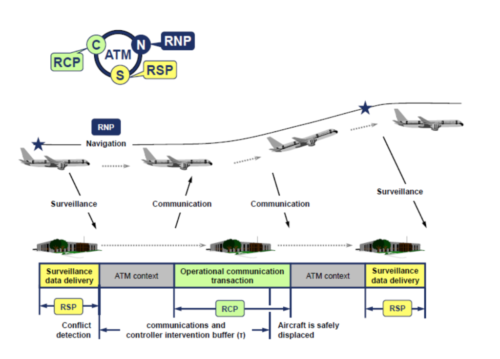
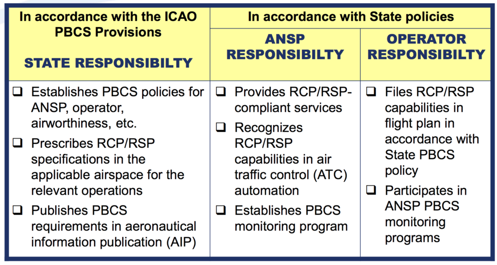
Requirements vary from state-to-state on the exact procedure for obtaining approval. It’s important to note that not all aircraft are automatically PBCS ready (refer to your aircraft manufacturer and your airplane flight manual).

The FAA has outlined its approval process here and has a handy powerpoint document here.

An important element is to prove that you have signed the “PBCS Global Charter” which can be found at the FANS Central Reporting Agency (CRA) website.

When a PBCS authorization is obtained an operator is required to file both P2 (indicating RCP240) in item 10 and SUR/RSP180 in item 18 of the flight plan, in addition to the J codes for CPDLC and D1 or G1 for ADS-C in item 10.

The correct filing of these two codes will indicate to any ATM ground systems applying performance-based separation minima that the aircraft is eligible for these minima and that the crew have received the relevant training in order to safely operate using the reduced separations.

Will you notice that PBCS standards are being applied to your flight?

Ok this is the funny part of this story. The short answer, probably not.

While it may be easier for RCP240/RSP180 approved aircraft to obtain optimal flight profiles, especially during high traffic periods, and particularly for NAT flights using the OTS, the application of these standards is generally tactical in nature for ATC. An aircraft may not have performance-based separation applied at all on an individual flight, or possibly may never have had it applied to any of its flights. Even if a you have RCP240/RSP180 approvals, if the aircraft nearby does not also have the approvals, the separation standards cannot be applied!

What if I don’t have RCP240 and RSP180 approval?

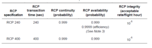
If you do not have RCP240/RSP180 approvals you will always have the larger separations, e.g. 10-min, applied, and not be eligible for the lower standards in cases where it may be beneficial.

The only airspace that has implemented tracks that will require PBCS to file is in the NAT OTS. There are still non-PBCS tracks in the OTS for which PBCS approvals are not required.

All other airspace in which performance-based separation minima are currently applied will allow aircraft with and without RCP240 and RSP180 approvals to enter and use the airspace in a mixed-mode operation.

Will I be penalized if I don’t have it?

Probably not in the short term. In the future as more and more airspace corridors become PBCS only, then it is possible you may be subject to reroutes, delays or the requirement to fly outside of certain flight levels.

So, our conclusion?

PBCS is a great step forward in maximizing efficiency in a busier airspace environment thanks to the advent of better technology. If you fly the NATs often and have an aircraft capable of PBCS certification standards, then yes – do it! The approval process is not overly burdensome, and many modern transatlantic jets already meet most of the technical requirements.

Ultimately, reduced separation standards mean more great air-to-air views. So, pack your camera!

Did we miss something, or does something need more explaining? Let us know!

Extra Reading:


NTSB: Current NOTAM system is “just a bunch of garbage”

You were all very supportive when we wrote the initial article on the BS Notam problem last year, and have followed our journey in fixing the problem since then.

Big news!

The NTSB called the Notam System a bunch of garbage on Tuesday this week, and assigned probable cause of the AC759 incident in SFO to the Notams that were missed.


What this means to OpsGroup is massive fuel to our fire: we are working hard to fix this problem, and having a public facing government organisation like the NTSB come down like a ton of bricks on the Notam System drives us forward in leaps and bounds.

The group members have been decisive in helping us to identify the problem and taking action to fix this. So, we want to acknowledge all of you! Great work!

In solving two of the above five problems, we have been working with ICAO for several months now. You all got involved in Normand 17,000 Notams later, we happy to report that version 0.1 of Norm is now live on the ICAO website. Norm is a bot – an AI, that has learned what Notams look like, and thanks to OpsGroup rating these 17,000 Notams, is also learning which ones are critical and which ones are not.

He’s still young. He doesn’t get everything, but if you feed him a Notam you’ll see him assign it a criticality of 1-5.

This will in turn allow us to sort Notams, putting the most important stuff first.


The risks posed to civil aircraft by surface-to-air missiles

In Short: Worldwide the SAM threat is deemed to be “low” by ICAO with the caveat that this can change quickly when flying over or near conflict zones. The best risk mitigation is centred around which airspace you are operating over and what information you have access to. As we have explained before: There is no safe altitude from a large SAM.

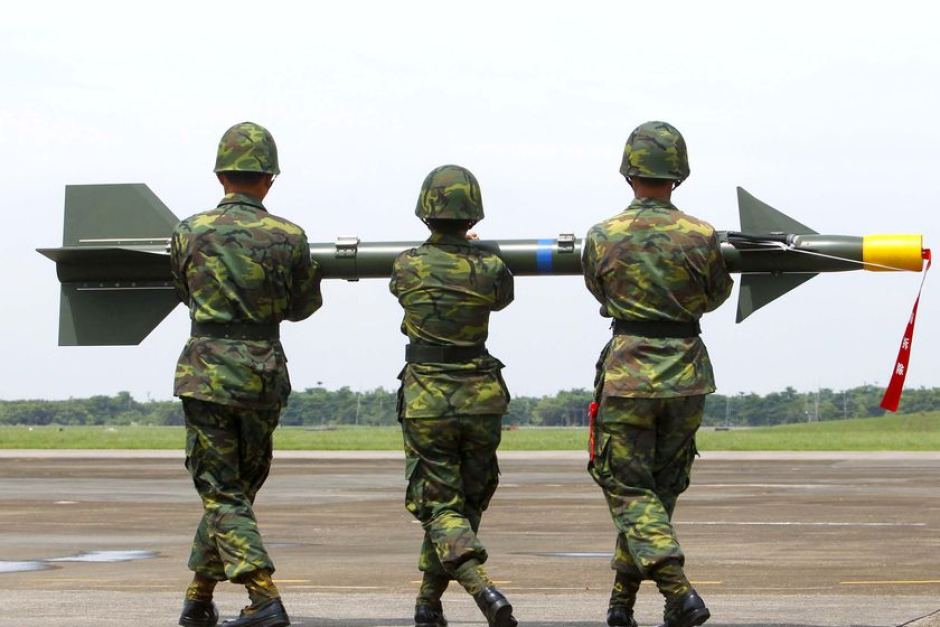
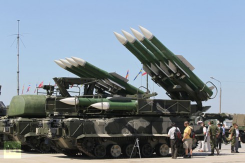
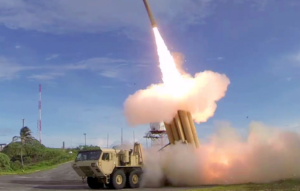
What are surface-to-air missiles, and who has them?

Surface-to-air missiles (SAMs) are large, complex units, with the capability of reaching aircraft at cruising levels well above 25,000 ft, and they are designed to be operated by trained military personnel.

They are distinct from Man Portable Air Defence Systems (MANPADS), which are the smaller, shoulder-launched systems, the most dangerous of which being the FIM-92 Stinger which has an operational ceiling of 26,000 ft.

SAM systems vary but they are all designed to track and destroy military targets in flight. Due to the size and predictable flight paths, civil aircraft represent easy and highly vulnerable targets.

Many SAMs are mobile and can be moved quickly between locations. Many are located on warships. It is estimated that more than 70 States around the world have acquired SAMs as part of their military capability. A small number of non-State actors (i.e. militant groups) have also reportedly acquired SAMs, but as they require a radar system as part of the mechanism, they may not have the technical capability to use them. To date, SAMs have never been used by terrorists.

What has happened in the past?

There have been three documented occurrences where aircraft destruction has occurred due to SAM attacks.

The risk of intentional attack

To date, no documented case of intentional SAM attack on a civilian aircraft has been identified. In the case of MH17 and Iran Air, both occurred during periods of military conflict or high tension, whilst Siberia flight 1812 was shot down during a military training exercise.

ICAO say that “with regard to the States and non-State actors that currently do have access to SAMs, there is no reason to believe that the intent currently exists to target civil aviation deliberately.” And with regards to terrorist groups (as opposed to militarized forces), they say that “even where intent may exist there is currently no evidence of capability (in terms of hardware and trained personnel).”

Overall, the current risk to aviation from intentional SAM attack is therefore currently assessed to be low, the key caveat being to avoid overflying airspace over territory where terrorist groups tend to operate – normally areas of conflict where there is a breakdown of State control.

The risk of unintentional attack

Past events show us that the higher risk to civil aviation is from unintended and unintentional attacks when flying over or near conflict zones – missiles fired at military aircraft which miss their target, missiles fired at civil aircraft which have been misidentified as military aircraft, and missiles fired by State defence systems intended to shoot down other missiles.

Areas where there are armed conflicts going on clearly present an increased risk of an unintentional attack. But when assessing the risk of overflying a particular conflict zone, here are some more specific questions to consider:

Are there increased levels of military aircraft flying around in the region?

This could be anything from fighter jets being operated in a combat role, or for hostile reconnaissance; remotely piloted aircraft; or military aircraft used to transport troops or equipment. If military aircraft are one of the most likely targets for intentional attacks, then the chances of civil aircraft being mistakenly targeted increases in those areas where there are lots of military aircraft zipping around.

Are there likely to be a bunch of poorly trained or inexperienced personnel operating SAMs in the region?

This may be difficult to evaluate, but the risk is likely to be highest where SAMs may have been acquired by non-State actors. The risk is also likely to be higher in places where there is less of a robust command and control procedure for launching missiles, thus increasing the risk of misidentification of civil aircraft.

Is the territory below the airspace fully controlled by the State?

If not, and there are some areas controlled by militant or terrorist groups, the information on the presence and type of weaponry in such areas, as well as the information on who controls them, may not be readily available. In such regions, the information promulgated by the State about the risks to airspace safety may therefore not be 100% reliable.

Does the route pass over or near anywhere of particular importance in the context of the conflict?

These could be areas or locations that may be of strategic importance or sensitivity in the conflict, such as key infrastructure or military sites, which might be considered potential targets for air attack and would therefore be more likely to be guarded by SAMs.


Ultimately, risk mitigation is centred around which airspace you are operating over and what information you have access to. But as has been reported in the past, history has shown us that badly-written information published by the State often does little to highlight the real dangers posed by overflying conflict zones.

There is some evidence to suggest that more States are starting to provide better guidance and information to assist operators in making appropriate routing decisions, but we think this still has some way to go.

That is why we have been running our safe airspace map to provide guidance to assist operators in determining whether to avoid specific airspaces around the world.


Extra Reading:


New CPDLC procedure on the NAT

There’ll soon be a new CPDLC procedure on the NAT, designed to prevent pilots from acting on any old CPDLC messages that might have been delayed in the network.

ICAO have published a new Bulletin for all the NAT Air Navigation Service Providers (ANSP’s) to use as a basis for implementing this new procedure. They recommend that all aircraft should receive a message immediately after they enter each control area telling them to “SET MAX UPLINK DELAY VALUE” to a certain number of seconds. The idea is that this will prompt the pilot to enter the specified latency value into the aircraft avionics, so that it will ignore/reject any old CPDLC messages.

So far, only Iceland’s BIRD/Reykjavik FIR have implemented this procedure, effective May 24. All other sectors of NAT airspace (Gander, Shanwick, Bodo, Santa Maria, New York Oceanic) are busy writing their own AIC’s and will implement later in the year. 

So when entering the BIRD/Reykjavik FIR, expect to receive a CPDLC message from ATC instructing you to “SET MAX UPLINK DELAY VALUE TO 300 SECONDS”. A copy of their AIC with more guidance can be found here.

The latency monitor function varies from one aircraft type to another: some just automatically reject old CPDLC messages, some will display a warning to the pilot that the message has been delayed, some have deficient equipment, and some do not have the message latency monitor function implemented at all.

Because of this, ICAO note that “it is impossible for ATC to tailor the uplink of the message… to different aircraft types. It has therefore been decided among the NAT Air Navigation Service Providers (ANSPs) to uplink this message to all CPDLC connected aircraft immediately after they enter each control area. An aircraft may therefore receive this message multiple times during a flight.”

So here’s the lowdown on what you need to do:

1. Work out in advance what kind of message latency monitor function your aircraft has, and what it is designed to do when it receives the CPDLC message “SET MAX UPLINK TIMER VALUE TO XXX SECONDS”.

2. When you receive this message, respond with the voice message “ACCEPT” or “ROGER”. If your aircraft has a functioning message latency monitor, punch in the specified number of seconds. If you don’t have functioning equipment, respond with the free text message “TIMER NOT AVAILABLE”.

3. If anything goes wrong, revert to voice comms.

Back in November 2017, we reported on an equipment issue with Iridium satcom that prompted a ban by a number of Oceanic ATC agencies. Some aircraft were receiving massively delayed clearances sent by ATC via CPDLC – and one took the instruction and climbed 1000 feet, even though the message was meant for the flight the aircraft operated previously.

Although the bans were dropped after Iridium fixed the problem at ground level (by ensuring the system no longer queued CPDLC uplinks for more than five minutes), this new CPDLC procedure on the NAT should ensure this kind of situation doesn’t happen again. It’s officially being brought in as one of the safety requirements for the roll-out of reduced lateral and longitudinal separation minima across the NAT, which is predicated on Performance Based Communication and Surveillance (PBCS) specifications – that means having CPDLC capable of RCP240 (4 minute comms loop), and ADS-C capable of RSP180 (3 minute position reporting).

Further reading:
ICAO NAT Bulletin 2018_002: CPDLC Uplink Message Latency Monitor
Iceland’s AIC on the new CPDLC procedure for the BIRD/Reykjavik FIR
– The latest PBCS rumours and facts
The latest NAT changes, including EGGX/Shanwick, CZQX/Gander, BIRD/Iceland, ENOB/Bodo, LPPO/Santa Maria, and KZWY/New York Oceanic East.
IRIDIUM satcom fault fixed


ICAO Raises Weight Threshold for Hardened Cockpit Door Requirement

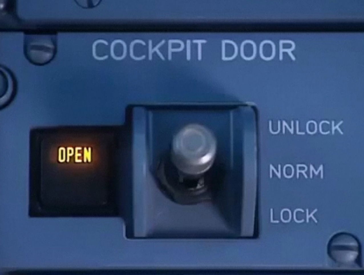
In Short: Following a three-year effort from industry groups and aircraft manufacturers, the International Civil Aviation Organization (ICAO) will raise the weight threshold for requiring hardened cockpit doors for aircraft with 19 or fewer passenger seats from 45.5 metric tons (100,310 pounds) maximum certificated takeoff weight to 54.5 metric tons (120,152 pounds).

This decision will enable the full type certification and worldwide use of current and future extended-range business aircraft such as the Bombardier Global 7000 and Gulfstream G650ER.

The International Civil Aviation Organization (ICAO) has changed its weight rules regarding strengthened cockpit doors on business jets. Toughened doors are required for aircraft operating charter flights.

Previous rules stated that hardened doors were needed for business jets with 19 seats or fewer, with a maximum take-off weight of 100,310lbs (45.5T). The new rules increase the maximum take-off weight to 120,152lbs (54.5T).

“This change maintains the security level intended by the original hardened cockpit door requirement, but recognizes the important distinction between airline service and business aircraft operations,” said Sarah Wolf, CAM, NBAA senior manager of security and facilitation.

The International Business Aviation Council (IBAC), in concert with the International Coordinating Council of Aerospace Industries Associations and aircraft manufacturers, proposed the changes to Annex 6 Part 1 – International Commercial Air Transport.

“The effort took much planning and working through the full standard-making process at ICAO and shows ICAO recognition of greater operational capabilities and industry evolution,” said IBAC Director General Kurt Edwards.

The new standard will become effective Jul 16, 2018, and applicable to member states in Nov 2018.


New ICAO SID/STAR Phraseologies from 10 November 2016 (or not?)

This is not going to be a short story.

But here’s the summary. In June 2016, ICAO updated Doc 4444 (the Air Traffic Control bible) with Amendment 7.

One of the main things this new bit does, is to change what the controller will say to the pilot, on a Standard Instrument Departure (SID), and on a Standard Instrument Arrival (STAR).

The new phraseology headline is “CLIMB VIA” and “DESCEND VIA”, but there are many more new parts to it.

So, here’s the problem. Doc 4444 is the master document, but each country has to implement the changes. And many are not – because they haven’t had time to train the controllers, or because they haven’t done a safety case (ie. figured out if anything in the new phraseologies might be dangerous), or … other reasons.

Some states have even published AIC’s to say that they won’t be implementing the changes (Australia, Switzerland). Others have already published the changes (Iceland, for example).

Confusing? You bet. For now, do two things:

  1. Read the new rules, because you’ll hear them from November 10th, but we’re not exactly sure where yet.
  2. Comment below and tell us any additional info you have.

The new rules are here:

  1. ICAO State Letter (the official version, with the verbatim changes to Doc 4444)
  2. A summary leaflet from ICAO – the highlights.
  3. SID/STAR Scenarios and Example Phraseologies from ICAO (a longer document).

We’ll keep this page updated as we hear more …

Will be implementing the change
Iceland
Latvia
Sweden (if we read AIP Supp 89 correctly)

Won’t be implementing the change – yet

Finland
Singapore
Australia
Switzerland
United Kingdom (not until late 2017, earliest)


Midweek Briefing: Australia Airport Workers Strike, ICAO Toughens Aircraft Tracking

Australia Airport Workers Strike 09MAR The Community and Public Sector Union (CSPU) announced the possibility of a strike during the week of 21 March, as well as three weeks of rolling airport strikes by Border Force and Immigration Department staff at international airports across the country. Airport staff members are expected to begin a work stoppage on 24 March, to coincide with the Easter holiday weekend, and will walk off the job at airports, freight terminals and other related sites. The work stoppages will be held to protest wage freezes and work conditions. Further details are likely to emerge closer to the strike.

ICAO Toughens Aircraft Tracking while in distress 02MAR The ICAO has announced new requirements for the real-time tracking of civilian aircraft in distress, following the disappearance of Malaysia Airlines flight MH370 two years ago. The ICAO’s governing council approved proposals for planes to carry tracking devices that can transmit their location at least once a minute in cases of distress. Aircraft operators will have to ensure their flight recorder data is recoverable, while the duration of cockpit voice recordings is being extended to 25 hours, ICAO said in a news release. These changes will take effect between now and 2021.


United States Visa Waiver Program Passport Requirements Take Effect April 1. Visa Waiver Program (VWP) travelers must present an e-Passport containing a biometric chip in order to enter the United States visa-free after March 31, 2016.  VWP travelers who do not hold an e-Passport should apply for a new passport as soon as possible to ensure that they can continue to use the program without interruption. The e-Passport requirement applies only to VWP travelers; it does not affect holders of U.S. visas.

Canada Electronic Travel Authorization Deadline Relaxed It has been announced that visa-exempt nationals who plan to enter or exit and re-enter Canada by air will be able to board their flight without an Electronic Travel Authorization (eTA) from March 15, 2016 until fall 2016.

India has extended its e-Tourist Visa program to applicants from 37 additional countries. Also, the visa-on-arrival program for certain Japanese nationals who are unable to apply for a regular or electronic visa has been relaxed to allow multiple visits per calendar year. Lastly, the deadline for Person of Indian Origin card holders to apply for the Overseas Citizen of India card in lieu of Person of Indian Origin card has been extended until June 30, 2016.

Ecuador The Ecuador’s Geophysical Institute reported that the Tungurahua volcano has experienced a series of eruptions. Pyroclastic flows and fallen ash have collected near the crater. During past eruptions, the volcano’s clouds of ash have disrupted flights to major airports in the region.

KZWY/New York Oceanic has issued NOTAM A0105/16 advising restrictions to routings in the WATRS PLUS area due to the (QVR) Oceana Radar being U/S on March 9th and March 10th between the hours of 14-22Z. The restrictions are issued as follows:

Northbound: L453 will be closed.

Southbound: M201 will be clsd btn int atugi and hanri.

Only aircraft equipped with operational ADS-260B out may use the following routes:

Southbound: L453 between LEXAD and ONGOT

North-eastbound: M201 between HANRI and ATUGI

All ADS-260B out aircraft must file an icao flight plan.

UIBB/Bratsk issued a NOTAM restricting the arrivals to only scheduled services due a fuel shortage until March 31st.

PKMJ/Majuro (Marshall Islands) Monthly tanker replenishment is planned for Mar 21-25. During this time, fuel will not be available.

VTSP/Phuket,Thailand has issued a NOTAM advising that the parking of private aircraft is prohibited overnight until April 25th.

Nigeria has experienced a country wide fuel shortage. Please check with your handler ahead of time to ensure fuel is available. Tankering is highly recommended until further notice.

LCCC FIR/Nicosia FIR Late notification of a military exercise in LCCC ACC starting on 09/03/2016 0300 UTC until 11/03/2016 1000 UTC. Exercise areas and route closures announced by following NOTAMs:

A0191/16 through A0196/16, A0208/16 and A0209/16 for area specifications. A0215/16 through A0220/16 for the route closures.

Please see the following graphic outlining the area:

Military Exercise Cyprus

View the full International Bulletin 09MAR2016