Africa ATC Strike
Update 01NOV
The threat of further ATC strikes in West Africa and Madagascar hasn’t completely gone away. The air traffic controllers union USYCAA have published an update claiming that ASECNA (the ATC agency) haven’t been sticking to the terms of an agreement reached on Oct 17 – they have been forcibly returning controllers to their countries of origin, cutting salaries, and freezing leave. There’s another meeting planned for Nov 7, so we should know more then.
You can read the original announcement (in French) here, or this translated copy.
Update 19OCT
USYCAA has cancelled any further strike action, following a meeting with ASECNA on Oct 17.
It looks like ASECNA have agreed to some demands (suspend pay cuts, provide indemnity insurance, set up a committee to talk with the union) but some still need to be resolved – mainly to restore all sanctioned controllers to their positions.
You can read the original announcement (in French) here, or this translated copy.
Update 11OCT
USYCAA has accused ASECNA of intimidating behaviour towards controllers ahead of a planned meeting on Oct 17 for negotiations to avert any further strike action. They cite “freezing without explanation of annual leave, verbal invectives, the unwritten suspensions of several air traffic controllers” among their claims.
You can read the original announcement (in French) here, or this translated copy.
Update 27SEP
USYCAA has suspended all strike action to allow for further negotiation with ASECNA planned for Oct 17.
You can read the original announcement (in French) here, or this translated copy.
ASECNA have also released a statement, which essentially claims there were no safety incidents during the strike, but doesn’t really say much more. You can read it from the source here (in French) or this translated copy.
Update 24SEP
As of 1200Z today, the ASECNA ATC strike action itself has ended. Per the controllers union, ops normal now. Arrested controllers have been freed, suspended controllers reinstated. However, caution should still be taken by crews as their grievances remains unresolved – both sides are now entering further negotiations for 10 days.
With so many FIR’s, ACC’s, and Terminal areas involved, the strike action has caused chaos in parts of African airspace. The heavy handed response by ASECNA, which included arresting striking controllers, has created a very sour atmosphere for ATC. This creates potential for lapses in judgement and safety concerns, even with the strike action over.
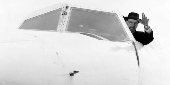
The major concern yesterday was the replacement of licensed controllers with military and other non-qualified staff, without any Notam or notification. Coordination between different units was unreliable, and many ATC centres were confused as to what the situation was.
For now, ops normal to some degree again – but all crews should still take great care until things settle down.
You can read the original announcement (in French) here, or this translated copy.
Update 23SEP
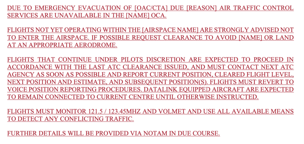
A very dangerous situation is developing today in the African ATC strike. Crews and operators should be aware that in a number of FIRs/ACCs/Towers, the normal controllers have been replaced earlier today with unqualified and unrated people. In simple terms, the voice on the radio is NOT an Air Traffic Controller.
From local sources we understand that GOOO/Dakar Oceanic and domestic, DXXX/Lomé, and FKKD/Douala all have unlicensed staff that have taken over the faciltiies. In FCBB/Brazzaville and FMCX/FMCH/Comoros, controllers have been arrested. In Niger and Madagascar, controllers have been suspended.
The situation is chaotic in many places and still developing. As of now, OPSGROUP recommends avoiding ALL ASECNA airspace unless you have certainty that the ATC service is licensed and safe, and until the situation is more clear.
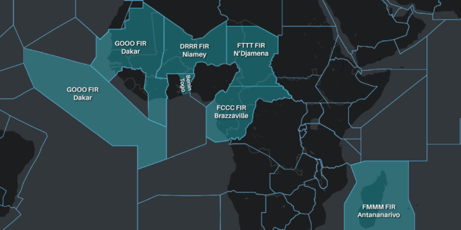
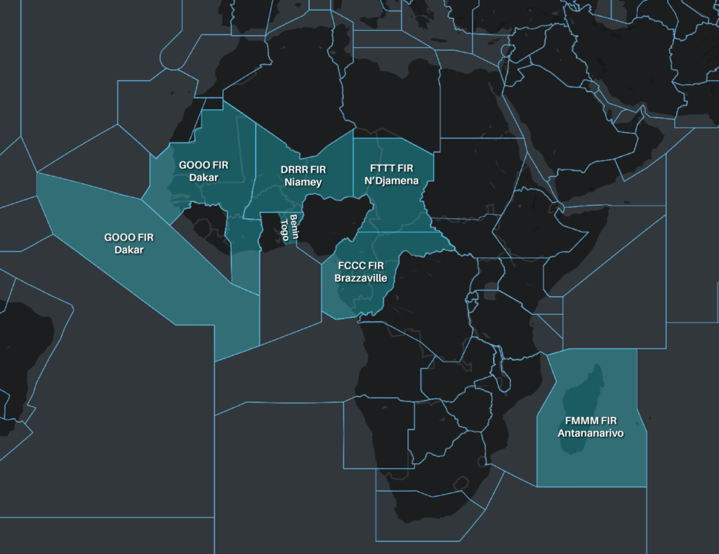
If you do have to operate through these FIR’s, be careful and cautious. ASECNA controls these areas: FMMM/Antananarivo, FCCC/Brazzaville, GOOO/Dakar Oceanic and Terrestrial, DRRR/Niamey, FTTT/N’Djamena, and the airspace of Togo and Benin.
We will update this further as we get more information. We also ask members to share any information they may have – email team@ops.group or WhatsApp the OPSGROUP Team at +1 747 200 1993
IFALPA have just published a bulletin about the situation.
And an update from USYCAA, the ASECNA Controllers union:
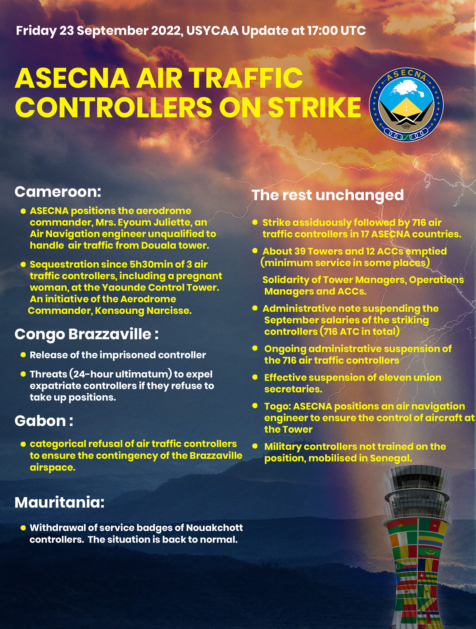
Click to open PDF.
Update 22SEP
Note: These updates relate to the situation when the strike was routine – before reports of unlicensed controllers started to emerge. Please use the info as background only.
- The ATC strike in West Africa and Madagascar is now underway, and is scheduled to continue until 0800z on Sep 25.
- The strike is taking place across several African countries covered by ASECNA: the FIRs of FMMM/Antananarivo, FCCC/Brazzaville, GOOO/Dakar Oceanic and Terrestrial, DRRR/Niamey and FTTT/N’Djamena; and the airspace of Togo and Benin.
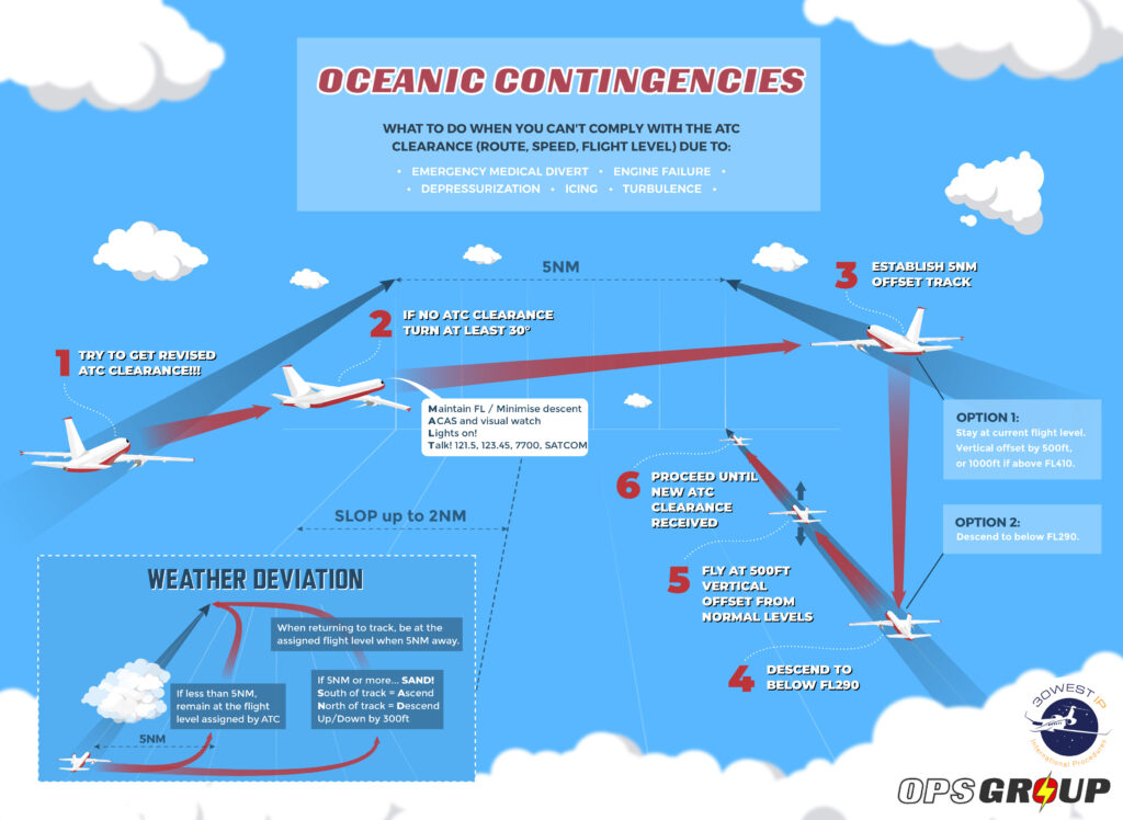
- For flights in these regions, the Contingency Plans now apply. Check here for those.
- The strike is also affecting flights in neighbouring airspace of GCCC/Canarias and DAAA/Algiers – Eurocontrol have published some rules and restrictions on flight planning there until the strike is over (see below).
GCCC/Canarias:
- Traffic crossing GCCC and exiting to the south into Cabo Verde will be restricted with low rates to FL340 and 380 on UN741 as well as FL300, 340, 360 and 380 on UN873 (except traffic arriving to GV).
- UN857 will be closed southbound from LZR to GUNET (except traffic arriving to GV).
- Traffic crossing GCCC and arriving to GV must file via EDUMO or IPERA.
- Traffic departing GC via LPPOOCA to GV can not fly via GOBEG, INSAD, IXILU, KUXOV, LAPTU.
DAAA/Algiers:
- Flight plans exiting DAAA airspace southbound not flying the contingency available routes will be invalidated with EU restrictions (i.e. For flights from Europe transiting through Algeria and into GOOO or DRRR airspace where the strike is happening, you have to make sure you flight plan to join where one of the contingency routes starts, otherwise Eurocontrol will reject your flight plan).
Where the ATC strike is happening:
ATC will ensure a minimum service is provided for flights involving:
- heads of state and government
- military
- carrying out medical evacuations
- of a purely humanitarian nature
- participating in search and rescue operations.
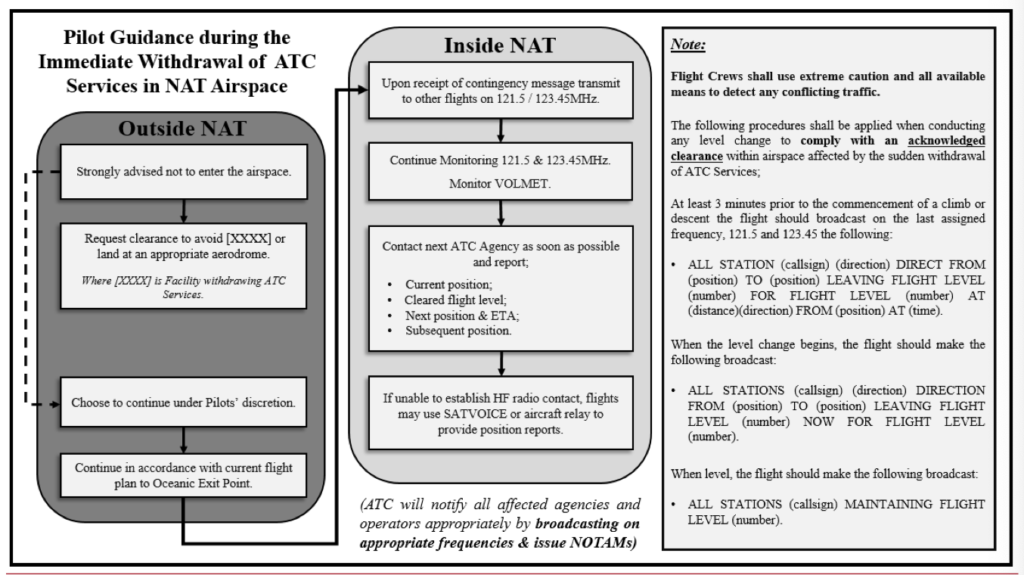
The Contingency Plans
ASECNA publish Contingency Plans, with a focus on maintaining overflights for international operations in cases of no, or limited, ATC services. You can find all the Contingency Plans here.
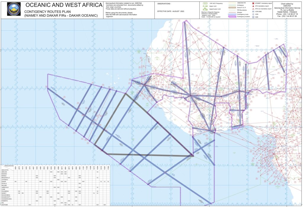
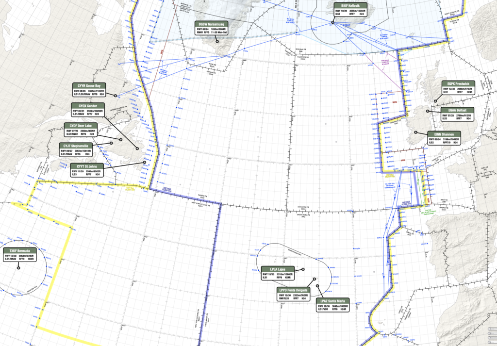
The Contingency Routes. Click on the image to head to the ASECNA website where you can download a hi-res PDF.
The Contingency plans effectively transfer control to neighbouring ATC controllers. An ‘ASECNA wide’ strike will therefore disrupt the level of effectiveness of these contingency plans.
There does tend to be a prioritisation, or at least measures to help ensure overflights can continue to a certain extent. Parts of African airspace already operate or have provisions for IFBP.
Other issues for ASECNA states
The ASECNA states have faced a fair few disruptions over the past few years.
ECOWAS states closed their land and air borders to Mali following a military coup.
Chad (FTTJ/Ndjamena FIR) had some issues back in 2021 during a period of escalating conflict and military control. Initially airspace and airports were closed, before contingency procedures came into force.
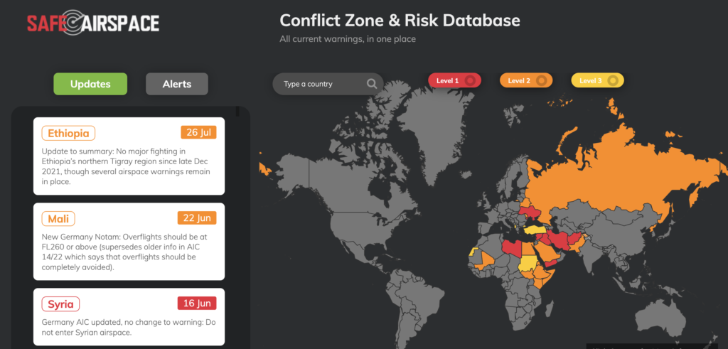
The African region is volatile, with security concerns on the ground in many countries, and some overflight cautions and warnings. Libya is a ‘No Fly’ country. There are warnings in place for Sudan, South Sudan, Eritrea, (northern) Ethiopia, Somalia, Kenya (bordering other countries), Western Sahara and Mali.
The limited diversion options across certain parts of the region due to safety and security concerns present planning issues for flights routing over northern and central Africa in particular. You can find more information on this by visiting Safeairspace.

 You’re better checking it directly at the airport than us trying to summarise them all.


 In case you aren’t familiar with these nuances of aviation lingo, here you go:

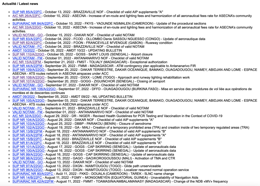

 And here are the Notams that carry the announcements of the closures: