Winter is coming, and that means two big things to think about in aviation. Operating in cold, wintery conditions and operating into cold, wintery ski destinations.
So, to help you avoid getting ‘piste’ with airport restrictions, parking problems and other annoying operational obstacles, here is a look at some of the main Alpine ski destination airports which you might be thinking about flying into later in the year.
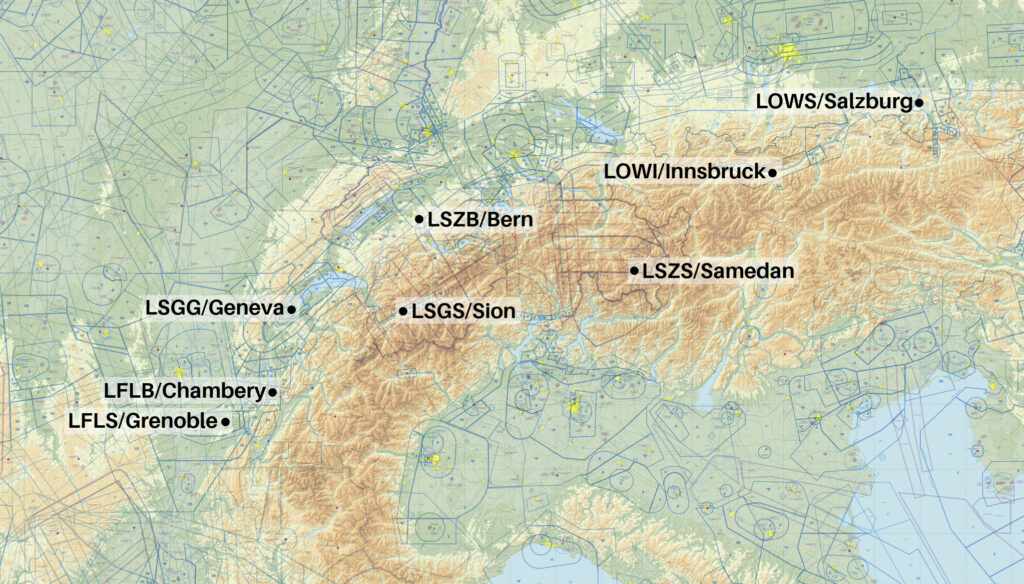 Innsbruck – Austria
LOWI/Innsbruck will get you as close as you can to Lech, St Anton, Zurs and Kitzbuhel.
It is 1hr 15 from Kitzbuhel by road, 90 minutes from Zurs or Lech, and 70 minutes from St Anton. Or about 25 minutes by helicopter from them all.
Innsbruck is one that you need to be familiar with, and have briefing material set up for, prior to operating in. The airport administration can provide a sample briefing, but you’ll need to tailor it for your operation. ernst.wieser@austrocontrol.at / ernstwieser@hotmail.com can help with that.
The full info is available in the Austria AIP, but you basically needed to have practiced in an FSTD before heading in with weather less than 3000’ ceiling or 5km visibility.
Slots are required here and the best folk to talk to are operations@innsbruck-airport.com
Innsbruck is not a big airport so parking is likely to be limited.
Airport Spy reviews give this a 3.5/5 rating.
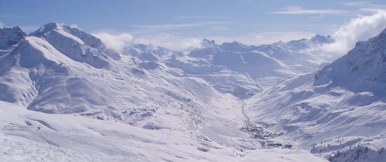
Zurs is high in the Austrian mountains
Salzburg – Austria
LOWS/Salzburg requires special permissions from Austrocontrol – special.procedures@austrocontrol.at
This is a larger airport with a 9022′ runway, ILS to 15 and CAT III capability. However, terrain at the end of runway 15 means there is a specific and challenging missed approach procedure fo runway 15, and a very challenging RNP procedure for runway 33.
Historically, a PPR has been required during the busy season from mid-December. Notams are usually issued in November confirming this, along with confirmations of charter and corporate slot availability.
Get your requests in early with +43 662 8580-261 / sas.ops@salzburg-airport.at
Chambery – France
LFLB/Chambery is best used if you want to head into Courcheval, Meribel or Val d’Isere.
You have probably heard of LFLJ/Courcheval Airport – it is the one in the mountains that is always on the top 10 scariest airport list. Chambery is *less of a challenge but you’re still going to need some training before heading in here, particularly if you plan to head in after dark, if the ceiling is less than 3500 or visibility is below 5000m. The airport has some terrain challenges of its own, sits at an elevation of 779′ and offers an ILS (in only one direction) to a 6627’/2020m runway.
The AIP says “Due to mountainous terrain in the vicinity of Chambery APT, it is considered essential that pilots are well familiar with approach, missed approach, circling maneuvers, and departure procedures. Therefore, concerned operators have to set specific operational instructions for the use of Chambery APT as well as provisions for their pilots’ training. The responsibility for the preparation of such information rests on the operator (or pilot-in-command for non-commercial flights).”
If you need ops assistance, the main business aviation FBO is available at +33 4 79 54 49 52 / fbo@chambery-airport.com
All the fees and charges are available here on the airport website.
The first 60 minutes of parking are free, after which they start to charge you 0.36 euro per ton (MTOW) per hour. Parking is arranged though SEACA (handling@chambery-ariport.com).
There is a dedicated business terminal and a good 30 parking spots at the airport, however, during peak times where forecast traffic exceeds capacity, they do ave scheduling in place. This means any take-off needs a PPR from the COHOR association.
Peak time is weekends (and some Fridays) from mid December to April, and the first week of January. You can email hdqcoxh.scr@cohor.org or slots@chmbery-airport.com to organise, or cy.myhandlingsoftware.com if you are a general or business aviation operator.
Contact the BRIA de Bordeaux : +33 5 57 92 60 84 and ensure you have a gendec for customs at least 24 hrs before arrival/departure.
Airport Spy reviews give this a 4/5 rating.
LFLJ/Courcheval is Chambery’s scarier neighbour, about 1 hour 15 minutes drive away
Grenoble – France
LFLS/Grenoble airport is well situated for at least 10 different ski resorts. It is an hour’s drive from Saint Pierre de Chartreuse, Chamrousse and Lans en Vercors, and up to 2 hours from other major resorts.
The airport has a 3050m runway and no specific qualification requirements for the ILS or RNAV procedures. They also up their RFF to a level 7 during the peak winter season (normally an RFF 5 with 7 on request).
The opening hours during the winter season will be 0700 to 2100 local time and can offer full security and customs without PPR.
However, it gets busy! It is the second most convenient after Chambery and particularly during February tends to fill up fast so you are going to need PPRs, slots and to confirm parking in advance. Slots and apron space are handled though the same myhandlingsoftware.
You can find the fees and charges on their main site.
We got in touch with businessaviation@grenoble-airport.com / +22 4 76 93 49 24 and they are very helpful and can assist in handling support.
We don’t have any Airport Spy reports for here yet! Send us one!
Bern – Switzerland
LSZB/Bern airport will get you close to Gstaad.
They have a very handy airport site with info for GA flights including an airport manual.
They don’t require slots and advised that they rarely see restrictions or capacity issues even during the busy season. As with many of these airports, they are not H24, but can offer different hours on request if required.
There is no pre-training required, but the airport is challenging. They have cold temperature corrections for the terrain (highest MSA is 15,800’) and the airport elevation itself is 1675’. The arrivals also take you through Class E airspace and VFR traffic without transponder and radio is common in the vicinity.
Reports for the airport suggest you may get terrain alerts, and preparing for the circle to land runway 32 with waypoints is a good idea. Our Airport Spy reviews gave it 4/5 stars and called it ‘tricky’.
Ground handling is mandatory here so get in touch with groundservices@bernairport.ch / +41 31 960 21 31 for info.
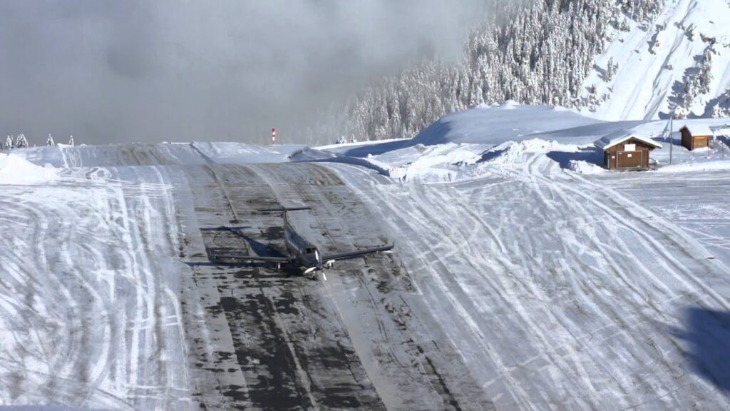
Gstaad does have its own airport – LSGK/Saanen – which, like so many, requires pre-training before you head there. You will need a PPR as well, but only a few hours before. The airport can handle jets up to at least a MTOW of 15,000kg and requiring up to RFF 5, but in winter they don’t have jets landing because of runway condition. So if you’re anything other than a Pilatus PC-12 or equivalent, stick with Bern.
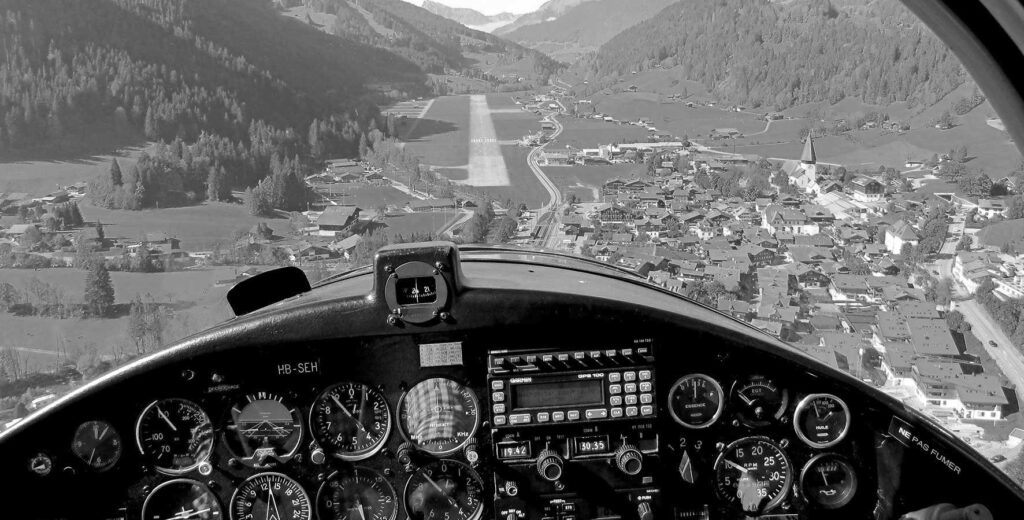
An old photo but gives a good idea of the challenges of this airport
Engadin (Samedan) – Switzerland
LSZS/Engadin, also known by some as Samedan is the closest airport for the St Moritz ski spot. It is actually a dedicated private jet airport just for St Moritz, and is barely a 10 minute drive from the ski chalets.
Parking here can get tight during Christmas, New Year and White Turf (weekends in February). There are limitations for jets with fire & rescue category 4 and higher.
Engadin was built, literally, into the mountains and you need prior training (and have to pass an exam) before going here. The main website provides some good briefing info on all this.
There are also some specific flight plan filing requirements for the airport – which you can read about here.
For handling support, get in touch with +41 81 851 08 51 / info@engadin-airport.ch
Airport Spy reports rated this airport 4.5/5 stars.
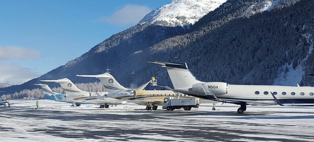
Anyone you know in this picture?
Geneva – Switzerland
LSGG/Geneva is the closest airport for the Chamonix resort, and is about 1 hour 20 minutes drive away, or has multiple helicopter transfer options.
There is no particular pre-training required to operate into Geneva, however it is a relatively challenging airport with very high terrain in close proximity. Check out our Airport Lowdown here.
Geneva is busy in the summer and busy in the winter. All year around really. But it does get particularly busy from December 15 to the end of April, and there are generally restrictions (and Notams) issued around this time.
You will need a PPR slot for arrival and departure. In the past there has been a maximum slot reservation window of 21 days.
This is where you need to head to check for info on all things PPR at Geneva.
Geneva has a dedicated business aviation terminal which is pretty convenient for the main terminal. There are three big hangars here, however, hangar space is limited during peak times and in the busiest part of winter often only the hangar run by the airport is available to “general public”. So get in touch and make arrangements early if you need them!
The main FBOs are:
You can find full details of Geneva Airport charges direct from the airport website.
Our Airport Spy reviews gave it 4/5 stars.
Sion – Switzerland
LSGS/Sion is the main airport for the Verbier, Zermatt and Villars resorts. The really posh ones.
Before we go any further into planning and operating there, you need to know that Sion does require special authorisation from the Swiss Authority because of the challenging procedures due terrain.
This authorisation requires pilots to undergo training before operating there, but there is a decent list of places where you can do this training, including training facilities in the US. They also have some great airport briefing info on their website.
Possibly because it is so challenging (guessing less folk fly there), the FBO we contacted advised that they don’t have any parking limitations at the airport, and that aircraft can stay for as long as they like, in a hangar too if needed.
For queries on handling, try Signature Flight support +41 27 305 2424 / sir@sigantureflight.ch
Our Airport Spy reports only rate this 3.5/5 stars. The VFR traffic makes it tough, but less challenging than some.
Where else?
We haven’t covered some of the bigger European airports which can be used for parking and to reach Alpine ski destinations.
LSZH/Zurich and the Milans (LIML/Milan Linate and LIMC/Milan Malpensa), as well as EDDM/Munich are all relatively convenient for ski destinations in the Alps and are larger airports which offer better parking, hangarage and easier operating options.
If you are familiar with other airports which are good options for winter ski destinations, then please share those “gotchas” or need to know “heads ups” – and we will share them on to everyone in the group. You can file an Airport Spy report here: ops.group/blog/spyreport


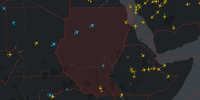
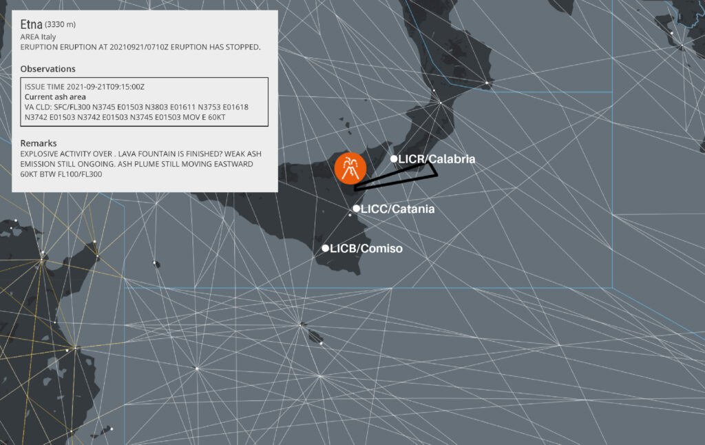
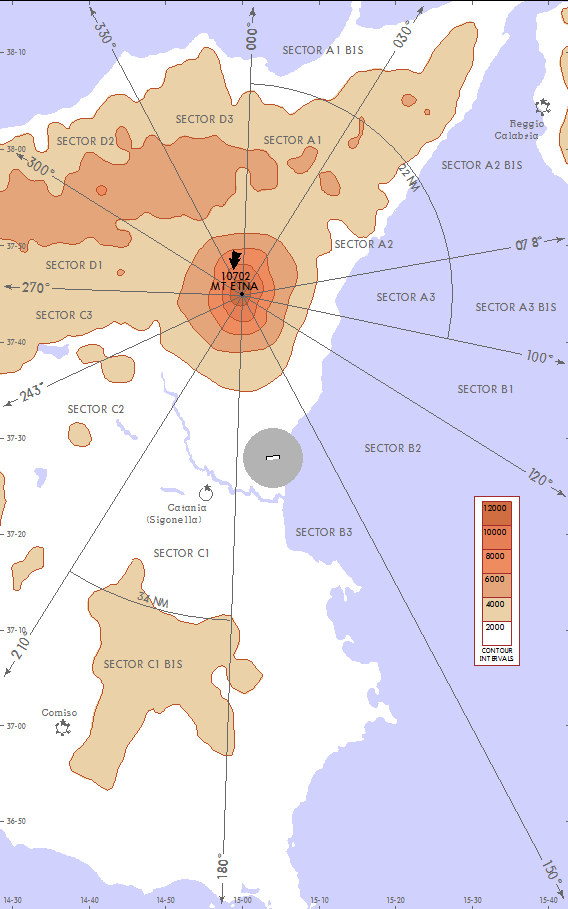
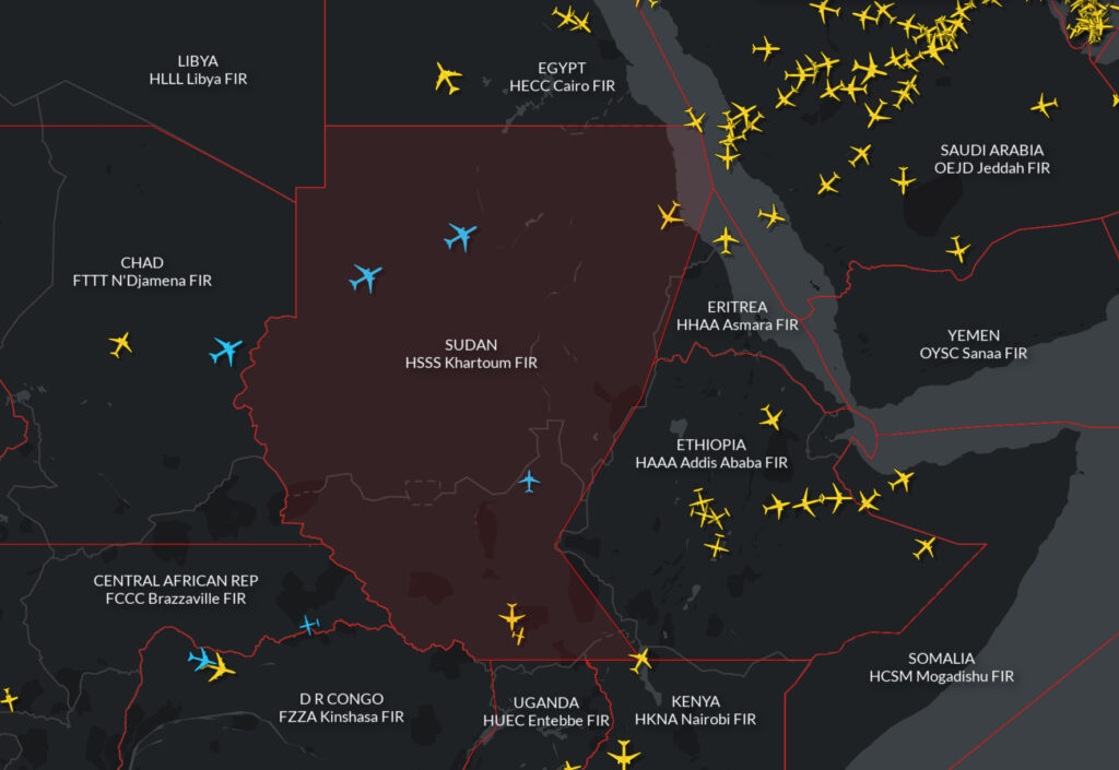 There is no immediate known risk to overflight safety due to the military takeover.
 Airspace warnings


 Anything else to know before I go?
 Is there any threat to civil aircraft?

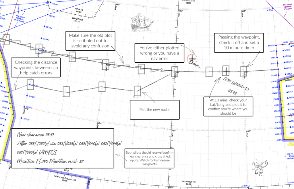
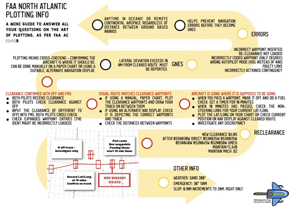
 To keep the traffic flowing, the FAA has published


 Any further information on this has not yet been provided, but when elections took place in 2018, there were a number of strikes which reduced public services to nearly zero, as well as violent protests and riots across the country. This resulted in a 24 hour closure in May 2018.