Dodging Danger: The Three Routes Through the Middle East

Navigating the airspace of the Middle East has become a major headache for international operators.

In recent times, risk to civil aviation in the region has changed at a pace we have never seen before.

Transits are now faced with a common conundrum: it no longer seems to be a simple question of ‘is this route safe?’ but instead, of one’s own appetite for known risks.

There simply is no ‘risk-zero’ route available.

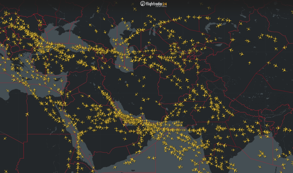
Therefore, a common question that bizav operators are asking OPSGROUP is ‘what are the major airlines doing?’ A snapshot of flight tracking right now shows that Middle Eastern transits are managing risk through the use of three distinct routes:

  • South via Saudi Arabia and Egypt
  • Central via Eastern Iraq and Turkey.
  • North via the Stans and the Caspian Sea.

This article provides a brief risk profile for each of these routes to help operators carry out their own risk assessments when choosing a route to fly.

A Note About Risk

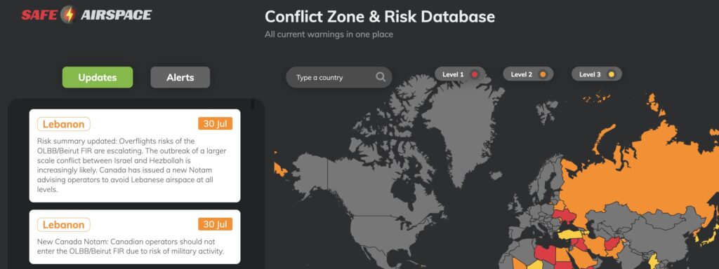
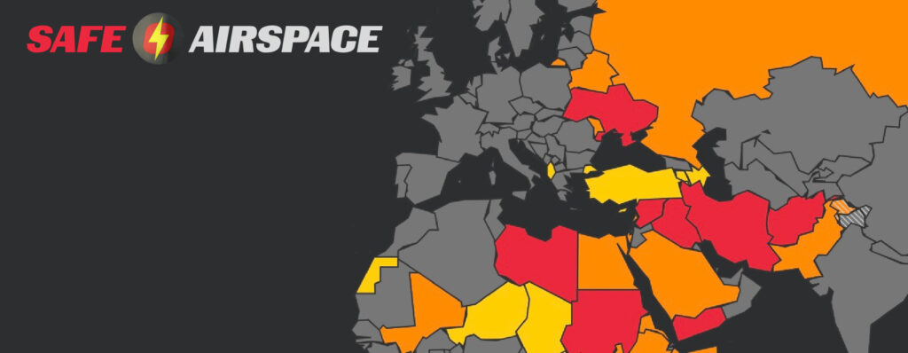
OPSGROUP also runs safeairspace.net – a database of all state-issued airspace warnings, along with risk briefings for each country in plain simple English.

We take into account both official advisories, recent and past events, advice from other specialists and potential for emerging risk when making a risk assessment.

To keep things simple we have three levels:

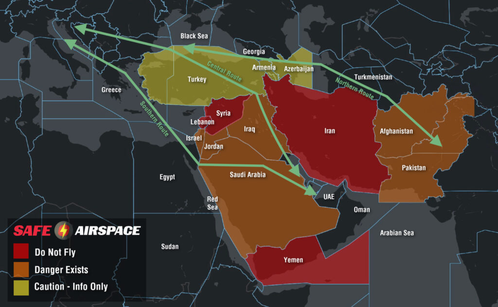
  • Level 1 Do Not Fly (Red)
  • Level 2 Danger Exists (Orange)
  • Level 3 Caution (Yellow).

None of the three routes above enter any country’s airspace we have classified as ‘Do Not Fly.’

For the rest, you’ll see the map below is color coded according to the same risk profile.

The Southern Route

This route begins with a lengthy crossing of Saudi Arabia, steering clear of Israeli and Lebanese airspace to the north before crossing the Red Sea into Egypt.

It’s considered advantageous because it keeps tracks miles down (compared to the Northern Route) and avoids the potential for a sudden escalation of hostilities between Israel and Iran.

From a contingency perspective, it also provides safer diversion options than a transit of Iraq.

But now for the more-risky stuff.

The Houthi Campaign:

There is currently heightened risks to civil aviation in this area.

Houthi Rebels in Yemen are currently engaged in a long-term campaign to use missiles and drones to target Israel (therefore infringing the Jeddah FIR) along with shipping channels in the Red Sea.

The military response to these activities is the use of air defence systems to destroy them.

The latest incident occurred on Nov 3, where a crew witnessed the interception of a missile at a similar level in open airspace near Jeddah. OPSGROUP members can access a special briefing on this latest event here.

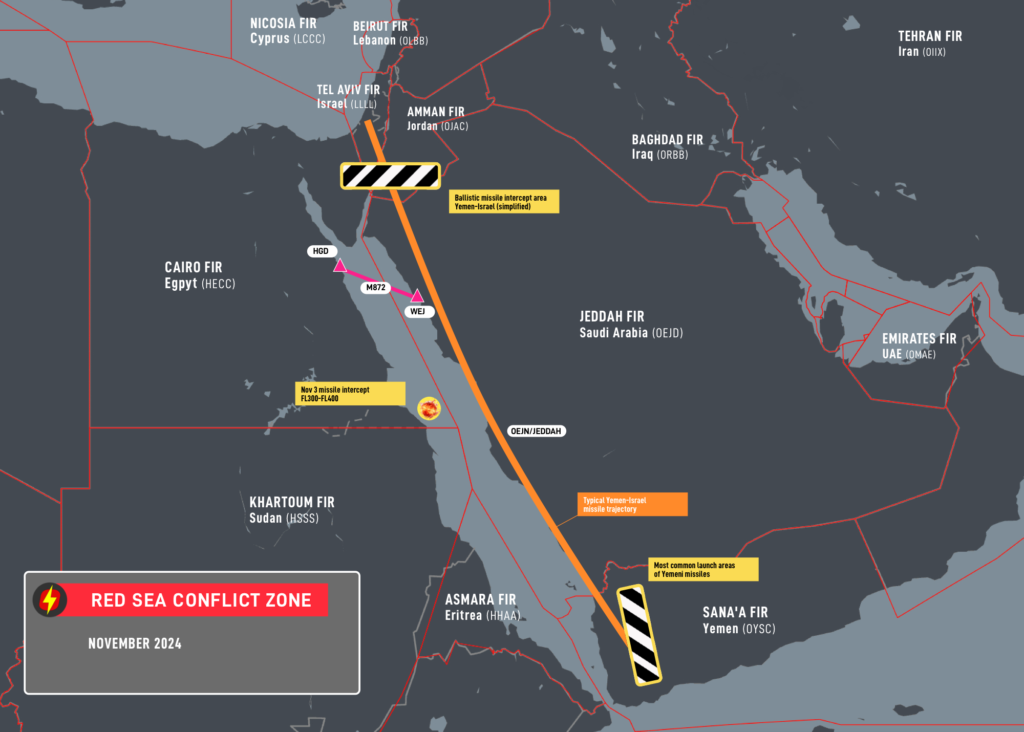
Of particular concern to aircraft at altitude is the use of ballistic missiles which originate from Western Yemen and are destroyed by defensive intercepts while on descent toward their target – which puts the airspace of Northern Saudi Arabia at heightened risk given its proximity to Israel and Gaza.

This essentially creates three risks to overflying aircraft – a direct hit by a missile (extremely unlikely), debris fields from inflight break ups or successful interceptions, and misidentification.

For the latter, many well-known incidents affecting civil aviation have come from mistaken identity. Malaysia 17, Ukraine 752 and Iran Air 652 were all due to misidentification.

Egypt ATC Congestion:

 OPSGROUP has received several recent member reports of severe frequency congestion in the Cairo FIR apparently due to ATC overload.

One crew even reported that during an entire portion between the North Coast of Egypt to the Red Sea (MMA – M872 – SILKA) that they were unable to talk to ATC.

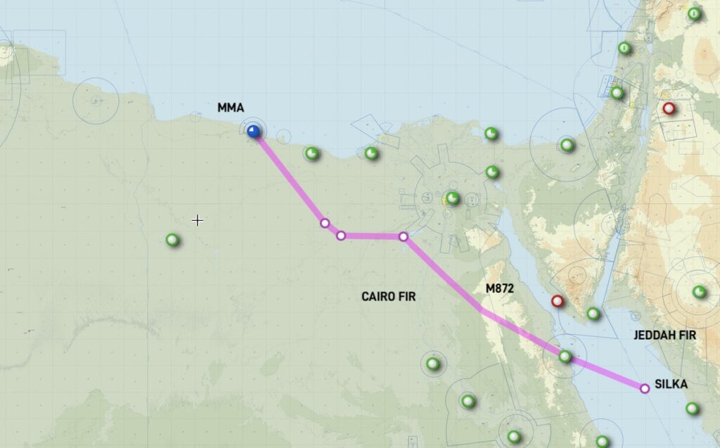
The corridor is much busier than usual which may present latent threats. Good airmanship at this time would be to keep a close eye on TCAS, ensure all anti-collision lights are on and consider the use of a PAN call if a deviation becomes necessary without a clearance.

We have approached both the Egyptian CAA and ANSP for feedback and have yet to receive a response.  If you have experienced this yourself in the HECC/Cairo FIR, please get in touch with us at team@ops.group.

The Central Route

This more conventional route tracks northwards along the Persian Gulf before an extended transit of Eastern Iraq using the UM860 and UM688 airways which run parallel to Iranian airspace before crossing Turkey and a southern portion of the Black Sea.

The overriding question from this route is “is it safe to overfly Iraq?”

In our opinion, yes but with some disclaimers.

UM860/UM688 Airways:

The UM860/UM688 have been considered safe for a long time. And prior to 2021, remained the only option available for US operators to enter the Baghdad FIR at all.

They continue to see heavy traffic by major carriers and can be considered a viable option.

When using them, an important consideration is their proximity to Iranian airspace. Due to the recent escalation in hostilities between Israel and Iran, many states prohibit operators from entering the Tehran FIR due the risk of anti-aircraft fire at all levels.

Extensive GPS interference (including spoofing) can be expected in Northern Iraq and on at least one occasion has led an aircraft to almost inadvertently enter Iranian airspace without a clearance.

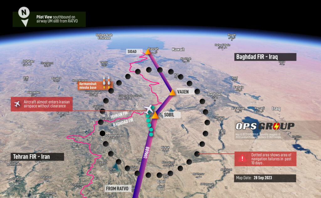
Extra vigilance for the early signs of GPS interference is essential for the safety of this route, along with early notification to air traffic control if it is suspected. Radar vectors remain your best fail safe.

Also beware of the potential for sudden closures of the ORBB/Baghdad FIR should further fighting occur between Israel and Iran. It closed completely during recent Israeli airstrikes and remains geographically sandwiched between the two, along with Jordan and Syria.

Free Routing:

In 2021, the FAA changed the rules. A new SFAR was issued that allowed N-reg overflights anywhere in Iraqi airspace, provided they’re conducted at or above FL320, which has opened-up new options for free routing.

Great for fuel, but arguably not safety. We continue to advise against flights away from the above airways due to well publicized risks of militant and terrorist activity which may target civil aircraft with anti-aircraft weaponry.

They may also be misidentified by air defense systems targeting drones which are frequently used to conduct attacks in Northern Iraq that originate from Turkey and Iran.

Crew and passenger safety is also an important concern should an emergency landing be required.

Turkey (beware of GPS interference):

We maintain a low-risk rating of caution for Turkey. As two of the three routes in this article include a lengthy overflight of the country, it is worth touching upon why any risk rating has been applied at all.

There is minor risk to overflights from misidentification by local militia who infrequently target Turkish military aircraft with anti-aircraft weaponry. This risk is predominantly near the border with Syria and Iraq where a higher level of airborne military traffic and UAS is present.

Far more prevalent is GPS interference – there have been frequent reports of both jamming and spoofing by aircraft well inside Turkish airspace. It appears to be common throughout the LTAA/Ankara FIR, especially anywhere near the border with Iran or Iraq. PIREPs also extend to Turkish airspace over the Black Sea. Reports share very similar symptoms: Un-commanded turns, position errors, and multiple GPWS warnings. The spoofed locations tend to center on Sevastopol on the Crimean Peninsula – a difference of between 120-250nm from the actual aircraft position. OPSGROUP members can access a special briefing on this hazard here.

The Northern Route

This is the route being favored between destinations in Europe and India/South East Asia.

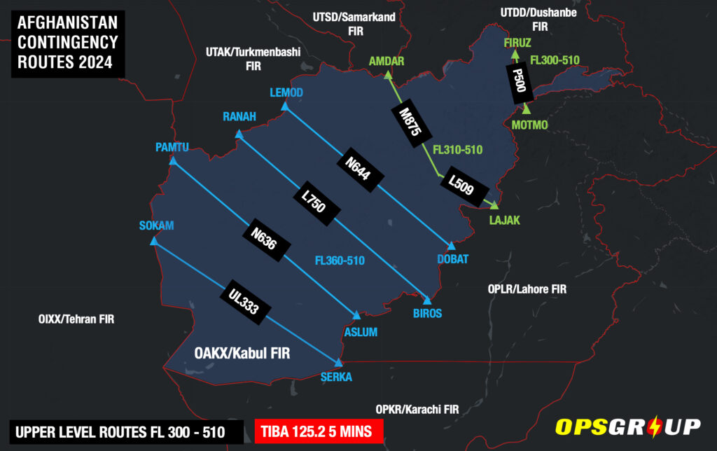
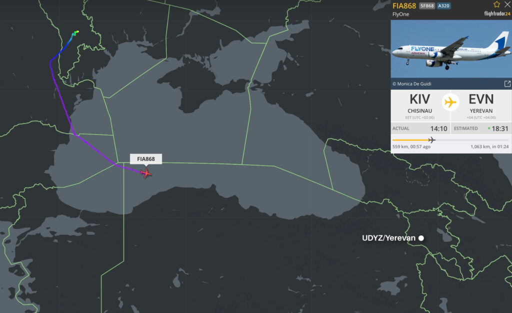
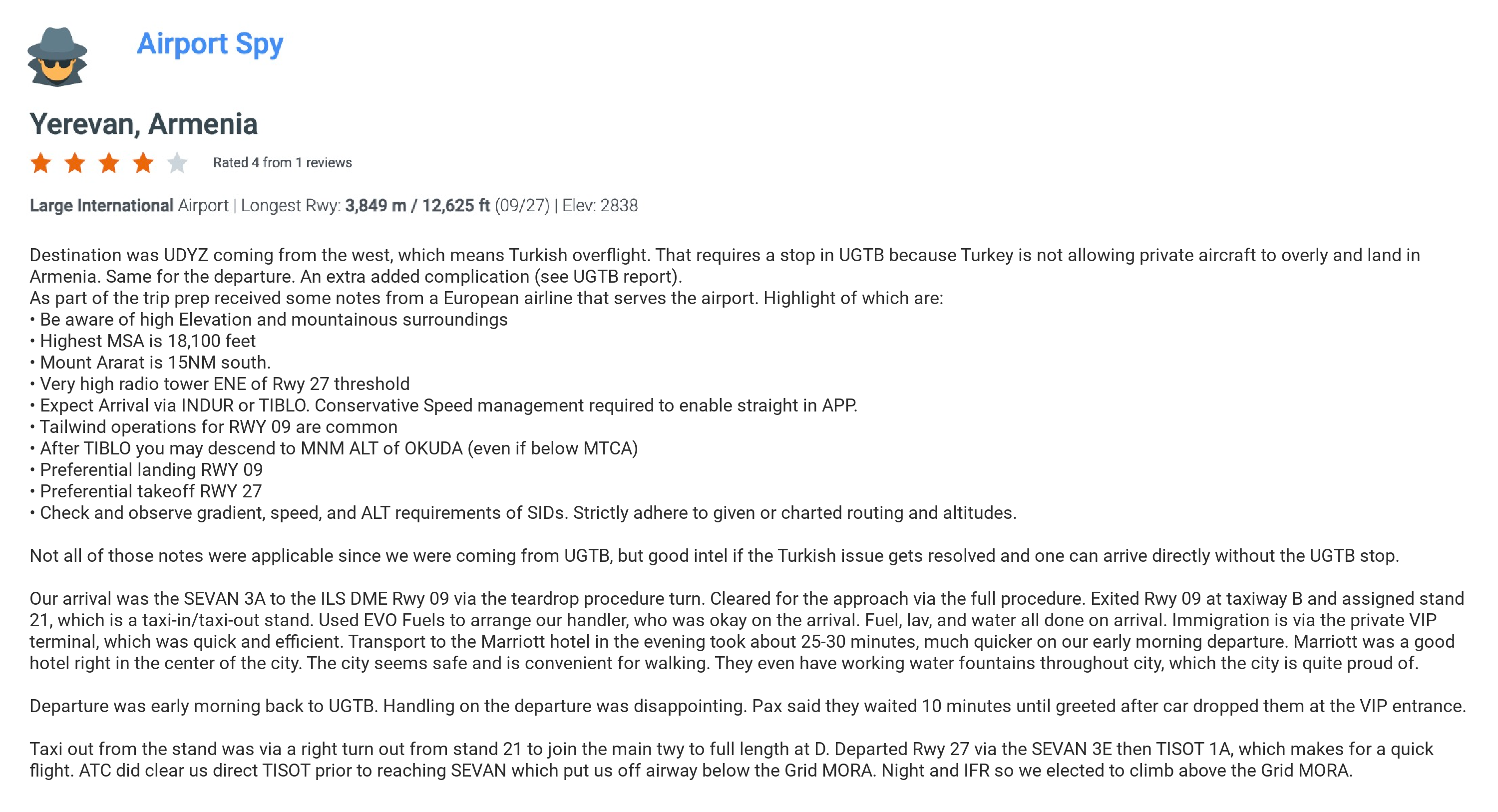
It begins with a transit of Pakistan, before an uncontrolled crossing of Afghanistan and into Turkmenistan. A westerly turn is then made cross the Caspian Sea, Azerbaijan, Armenia and Turkey before rejoining the central route over the Black Sea.

While a fairly conservative option, it is the longest in terms of track miles.

Afghanistan:

For all intents and purposes, airspace safety in the Kabul FIR has not changed since the Taliban re-assumed control of the country in late September 2021.

The entire FIR remains uncontrolled and there is no guarantee of crew or passenger safety if you need to land. In that sense it remains the most important consideration in the selection of this route.

With that said, adjacent FIRs are managing the entry and exit of traffic and separating them with miles-in-trail and level restrictions.

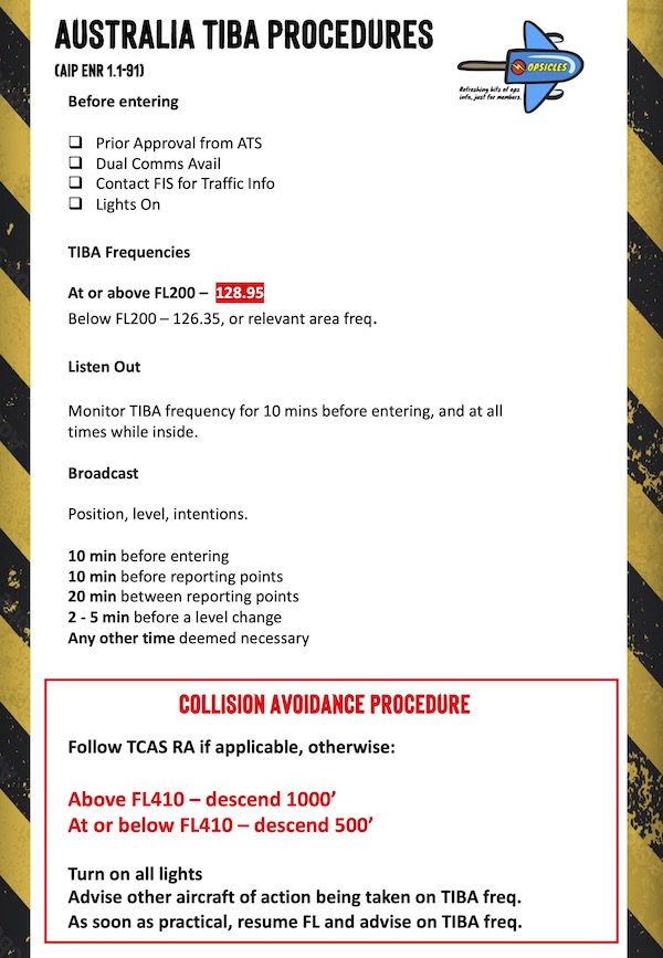
Once inside, fairly robust contingency procedures (including the use of TIBA) appear to be working, with major carriers the likes of Lufthansa and KLM making safe crossings every day.

Aside from potential insurance complications of extended flight in uncontrolled airspace, it seems the predominant risk for overflights is what happens if you have an emergency and need to divert.

The overriding consensus (along with common sense) is don’t land in Afghanistan. In our recent article we explained it would be wise to consider it akin to ditching i.e. a last resort. Careful consideration of critical fuel scenarios to clear the Kabul FIR in event of de-pressurization, engine failure or both is essential to moderate this risk.

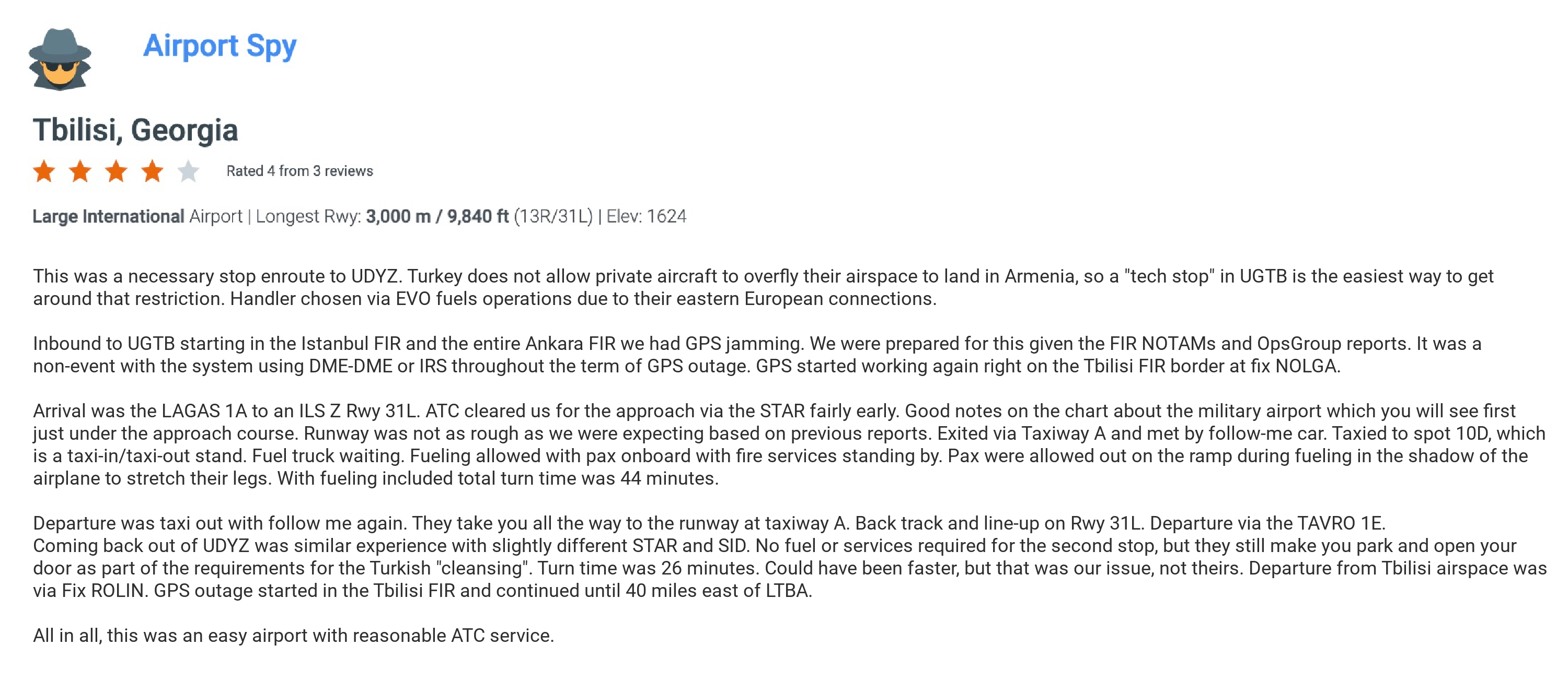
Azerbaijan and Armenia:

We maintain a level of caution for overflights of these countries given their history of conflict, but for now the risk to overflights remains low.

A ceasefire agreement is in place, and most states have lifted their airspace warnings for the YDDD/Yerevan and UBBA/Baku FIRs.

When sporadic fighting has occurred, it has been confined to border regions. A contingency to keep to mind is the use of northerly waypoints BARAD, DISKA and ADEKI to avoid the area and transit from Azerbaijan through Georgia instead.

Stay Informed

The situation in the Middle East has recently proven that airspace risk can change quickly and without warning.

Overflights need to stay informed and have good contingencies in place to manage unexpected re-routes and airspace closures, along with suitable diversion airports.

OPSGROUP issues Ops Alerts for members on a daily basis, but our risk and security alerts are also available for free on safeairspace.net which our team keeps updated around the clock.

If you have more questions, you can get in touch with us on team@ops.group. We’d love to hear from you.


Canada ADS-B Mandate

Key Points
  • ADS-B became mandatory in Canadian Class A airspace in Aug 2023 (above FL180). It then became mandatory in Class B airspace (above FL125) in May 2024. Mandates in any Class C, D and E airspace will be determined no sooner than 2028.
  • You need an antenna able to broadcast to ADS-B receivers both on the ground and in space, and you need to include some extra stuff on your flight plan.
  • If you don’t have ADS-B, you have to apply for an exemption online from NavCanada.

What equipment do I need?

  • A transponder with ADS-B out capability that meet the minimum performance standards (or better) found in this fancy document. This needs to be attached to an antenna that can broadcast to ADS-B receivers both on the ground, and in space.
  • You can also find more on this in section 551.103 of the Canadian Aviation Regulations.

Extra Flight Planning Requirements

  • If you plan on entering airspace where the ADS-B mandate applies, there is some extra stuff you need to include in item 10b of your ICAO flight plan (assuming you have all the right gear on board).
  • Use the code B1 if you have ADS-B Out only, or B2 if you have ADS-B In and Out.
  • You’ll also need to include SUR/CANMANDATE in item 18.
  • One other gotcha – make sure the flight identification (flight number or aircraft reg) broadcast by your ADS-B equipment exactly matches the one used in item 7 of your flight plan. Lest there be trouble down the track!

My ride doesn’t have this fanciness. What are my options?

  • NavCanada will do their best to accommodate aircraft who don’t have the right gear on board, in the same way they’ll work to fit non-transponder equipped aircraft into transponder mandatory airspace.
  • They’ll assess each application on a first-come, first-served basis. It takes time to figure out behind the scenes, and so you’ll need to ask at least three business days before your flight.
  • There may also be suggested re-routes to make your request possible, along with special comments to include in Item 18 of your flight plan.
  • You can apply for an exemption online, here. If you have a number of flights to operate, you can also submit a blanket request via service@navcanada.ca.

To enter mandated airspace without ADS-B, you’ll need prior approval. Click the image above for that.

More Info

You can find that in the Canadian AIP (ENR 1.6.3), or even better – this page from NavCanada dedicated to the ADS-B Mandate. This includes a fairly extensive FAQ section at the bottom.

All your Canada ADS-B questions answered!


Bizav Roadblock: Turkey and Armenia

UPDATE 30 Oct 2024:
  • Turkey has reportedly started allowing bizav overflights heading to/from Armenia.
  • This issue stretches back to May 2023, but Turkey dropped the restriction in Sep 2024.
  • So if you’re heading to Armenia (UDYZ/Yerevan, for example), you can now overfly Turkey – you no longer have to route around the country or make a stop somewhere like UGTB/Tbilisi in Georgia.

Turkish Ban

Back in May 2023, Armenian airline FlyOne operating a Paris-Yerevan flight had to make an emergency landing in Chisinau after being denied entry to Turkish airspace.

Turkey reportedly applied this last-minute ban in response to a monument erected in Yerevan the previous week, which they were unhappy about.

Pretty soon after, FlyOne evidently managed to resume Turkey overflights, but it seems that this restriction was still informally applied to bizav overflight requests.

30 Oct 2023: FlyOne from Chisinau to Yerevan merrily overflying Turkish airspace again.

OPSGROUP Member Reports

There was no Notam published on this issue, nor anything mentioned in the Turkish AIP. But some operators made tech-stops in Georgia to fix the problem. In Oct 2023, two Airport Spy reports were received from OPSGROUP members, where they required a tech-stop at UGTB/Tibilisi (Georgia) before continuing on to UDYZ/Yerevan (Armenia) in order to overfly Turkish airspace:

Spy Reports

If you have managed to get a Turkey overflight permit for a flight heading to/from Armenia, please let us know! You can also reach us directly on news@ops.group, or file an Airport Spy report.

OPSGROUP members can access the full Airport Spy database via the members dashboard here.

Turkey or Türkiye?

Just a final note on this… In June 2022, the United Nations agreed to a formal request to recognise Turkey as “Türkiye”, as part of a rebranding campaign launched by the Turkish president.

However, no major media outlets have changed their spelling so far. So for now at least, Turkey remains Turkey.


Hurricane Milton – Florida Under Warning

** Final Update Oct 11, 0500z.

Hurricane Milton has now weakened into a tropical storm and is headed away from Florida into the Atlantic. It will pass south of Bermuda on Oct 12 but with little to no impact expected at TXKF/Bermuda. Damage assessments at airports are still underway.

Here is a summary of the current situation as at 0500z Oct 11 – unless things change, this will be our last update on Milton.

Mexico

The Northern Yucatan Peninsula is no longer under any active storm warning or advisory.

The only aviation impact was to MMMD/Mérida which re-opened on Oct 8 – no significant damage was reported.

Gulf Routes

Gulf route closures as a direct result of Hurricane Milton have now finished.

Florida

The worst is now over for Florida – Milton is tracking eastwards away from land and into the Atlantic. Most airports are planning to reopen today (Oct 11), however damage assessments are still ongoing so Notam timings may change or be extended.

Airport Closures

KTPA/Tampa                                          Re-opening Oct 11, 1200z (est.)

 KPIE/St.Pete-Clearwater               Re-opening  Oct 11, 2000z (est.)

KSPG/St.Petersburg                          Re-opening Oct 12 1600z (est).

 KSRQ/Bradenton                                Re-opening Oct 12 1000z (est.)

 KMCO/Orlando                                     Open *Fuel limited, check availability.

 KMLB/Melbourne Orlando              Re-opening Oct 11 1300z (est.)

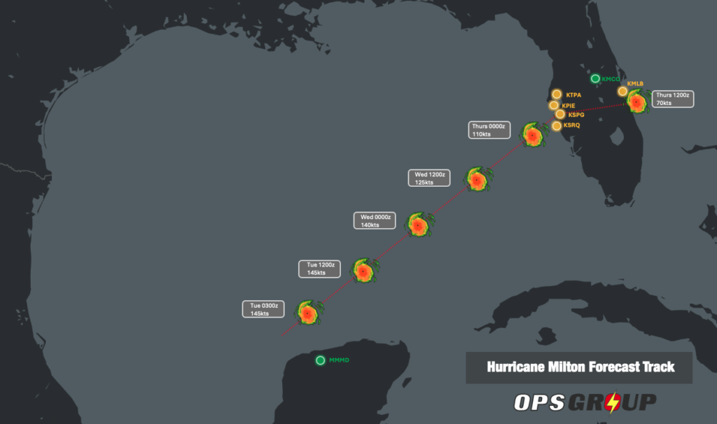
The FAA has now finished its telcon briefings for Milton.

Stay Informed

For live operational updates, keep an eye on the FAA NASS website which will be updated constantly as Milton passes.

The National Hurricane Center will provide accurate forecasts and tracking info here.

Have we missed something? If you have an update to share regarding airport or airspace status, please reach out to us via news@ops.group.


NAT Conundrums: Volume I

Originally published 2021, Updated 2024

It’s no surprise to most that the North Atlantic is the busiest oceanic airspace in the world. To keep things running smoothly there are a bunch of procedures to follow. We write about them a lot, especially when they change. From time to time questions continue to pop up that make us scratch our heads. And so we thought this might be a good chance to share a few of those with you – naughty NAT conundrums if you will.

To SLOP or not to SLOP?

Chances are if you fly in oceanic airspace you already heard of Strategic Lateral Offset Procedures (SLOP). They’re pretty straightforward – you’re supposed to offset up to 2nm right of track without needing a clearance.

We do this because humans are fallible and mistakes can be made. Ironically the extreme accuracy of modern navigation systems mean that in the case of gross navigational errors, level busts or incorrect clearances, these systems actually increase the chance of a collision. So we pull over to the side of the road a little more, just in case.

Do we have to SLOP?

If you’re in the NAT HLA and your aircraft is capable then yes, it’s ‘required’ (as per ICAO NAT Doc 007). The only time you shouldn’t is if your aircraft’s FMS cannot automatically maintain an offset i.e. it doesn’t have that function. In that case you ‘must’ stay straight up the middle.

Remember, your SLOP can be in increments of 0.1nm and “0 nm” SLOP is also a thing!

You SLOP from the ENTRY point only, and need to have stopped the SLOP by the EXIT point.

  • Don’t go ‘direct to’ the EXIT, this will put you on a different track. Cancel the SLOP to return to ‘centreline’
  • Only SLOP from the ENTRY to the EXIT
  • If you are routing from a NAR into the NAT, the last point is your entry into the NAT and you can SLOP from here

Can we SLOP in the Oceanic Transition Areas?

Or in other words in NOTA, SOTA, BOTA or GOTA? Good question.

NOTA and SOTA: The short answer is no. The slightly longer one is that the both NOTA and SOTA are under radar control with domestic separation from Shannon Radar. You should only apply SLOP between your oceanic entry and exit points.

BOTA: It’s a similar story. BOTA radar control services are provided by Brest Control in France – essentially domestic rules still apply. So no SLOP-age.

NOTA, SOTA and BOTA on the European side.

GOTA: This is the odd one out. GOTA (the Gander Oceanic Transition Area) is off the coast of North-eastern Canada. You should SLOP only once you have passed the Oceanic Entry Point (OEP) eastbound and within Oceanic Airspace “proper”, and vice versa westbound – sto SLOP at the Oceanic Exit Point (for example NIFTY on the chart below).

Are there any other ‘gotchas’?

Yes – three main ones:

  1. The ENOB/Bodo and BIRD/Reykjavik FIRs. Look out for these. Buried in the NAT Doc 007 it says that you are only allowed to SLOP above FL285. So don’t get caught out in the lower levels.
  2. Tango Routes T9 and T290. These lie just outside of BOTA airspace. According to the UK AIP ENR 3.5, SLOP does not apply here.
  3. And whatever you do – never SLOP left!

What’s the difference between the NAT Region and the NAT HLA?

The NAT Region is virtually all of the non-domestic airspace over the Atlantic – from around 20 degrees north all the way up to the pole (excluding New York Oceanic West). It contains seven Oceanic Control Areas – BGGL/Nuuk, BIRD/Reykjavik, ENOB/Bodo Oceanic, CZQX/Gander, EGGX/Shanwick, KZWY/New York Oceanic East and LPPO/Santa Maria.

Within the NAT region (and occupying a large amount of it) is the NAT HLA, which stands for High Level Airspace. It only exists from FL285 to FL420.

Because the NAT HLA is some of the busiest airspace in the world, there are a number of stringent navigation and communication requirements that you must meet to enter it. This includes being either RNP 4 or RNP 10 capable, having two independent long range navigation systems and in most cases, datalink. Operators also need state approval.

If you don’t meant those requirements you can still fly through the NAT Region, but you’ll have to fly below or above the NAT HLA. Blue Spruce routes are the exception, which allow aircraft with only one long range navigation system or limited comms equipment to enter.

Nat HLA Airspace (Flight Level 285 – 420)

Can I fly across the North Atlantic without Datalink?

Yes, but it’s gonna be tricky.

The North Atlantic Datalink Mandate (NAT DLM) means aircraft need to have CPDLC and ADS-C to operate between FL290-FL410 throughout the NAT Region.

There are a few exceptions where the NAT DLM does not apply:
– Everything north of 80°North.
– New York Oceanic East FIR.
– Tango Routes T9 and T290. The other Tango Routes (T213, T13, T16) all require datalink.
– ATS Surveillance airspace, where surveillance service is provided by means of radar and/or ADS-B, coupled with VHF.

That last one about “ATS Surveillance airspace” is essentially just a section of airspace over Greenland and Iceland, which looks like this:

The blue shaded area shows the datalink exempt “ATS surveillance” airspace.

So if you’re on a NAT crossing and you don’t have datalink, you technically have to stay below FL290 until you hit the blue shaded area. It’s worth noting that aircraft without datalink can request to climb/descend through datalink mandated airspace, but will only be considered on a “tactical basis” by ATC.

Further south, there is another section of “ATS Surveillance Airspace” in the area connecting the LPPC/Lisboa FIR (i.e. mainland Portugal) to Madeira and the Azores, which is also exempt from the NAT DLM:

So in theory, an Atlantic crossing without datalink would also be possible here – within the LPPO/Santa Maria FIR you would just have to ensure that you stay below FL290 or above FL410 outside of the bubbles until you reach the KZWY/New York FIR (where the NAT DLM does not apply).

Even further south, in the TTZP/Piarco and GVSC/Sal FIRs, CPDLC is the primary means of communication, but it’s still not mandatory.

So down south, the bottom line is that as long as you stay out of the LPPO/Santa Maria FIR between FL290-410 where the NAT DLM applies… except for the ATS Surveillance Airspace bubbles where it doesn’t apply… then you’ll be ok with just HF. Got it? 😊

For more info on the NAT Datalink Mandate, check out our previous article.

So, what’s your conundrum?

We’d love to hear it. Chances are if you don’t know the answer, many other people won’t either, so it’s always great to share.

Get in touch with us at team@ops.group with your question, and we’ll include it in the next article on Naughty Nat Conundrums.

And if you want to download a PDF of our North Atlantic Plotting Chart, check how to get a copy here.


Vegas F1: Brace Yourself for Special Event Fees

Brace yourself – the Formula One Grand Prix in Las Vegas is just around the corner, and metropolitan area airports are about to get really, really expensive. Here is an early rundown on what to expect so you can start planning your trip early.

The Grand Prix

The FAA has published the procedures for this year’s event yet here.

While race day is Nov 24, special procedures will apply at KLAS/Las Vegas, KHND/Henderson, KVGT/North Las Vegas and KBVU/Boulder airports from Nov 19–26.

All arrivals and departures will need a PPR number issued by an FBO, including drop-and-goes. You’ll need to include this in Item 11 of your flight plan.

Don’t be tempted to try and land without one. Airport authorities will not allow you to de-plane your pax and you’ll need to gas up and leave again without delay.

If you’re looking to park overnight, book now. Last year it got so busy that the only option for many was to purchase a drop-and-go slot allowing thirty minutes on the ramp to offload, and another thirty to pick up.

Note that Signature FBO still cannot accommodate aircraft with wingspan more than 80ft, due to ramp construction works. Atlantic Aviation (the only other FBO at the airport) don’t have any similar restrictions.

Even airports further afield, such as KBVU/Boulder City are already reporting they’re booking up. If you’re really stuck, it might be worth considering the likes of KIFP/Bullhead City (Signature) or KSGU/St George (Million Air) – although these would mean a long drive to downtown Las Vegas.

Traffic Jams

Inevitably, arrival rates will exceed airport capacity. ATC will use terminal initiatives to put the brakes on. It may go without saying, but it’s important to carry extra fuel for airborne holding and reroutes.

Domestic IFR aircraft can also expect Departure Clearance Times for all inbound flights to the three major airports.

Within 200nm of the Vegas terminal area, ATC will not process airborne reroutes or changes of destination unless there is an emergency.

Special Event Fees

The biggest gotcha for anyone operating an aircraft to Las Vegas during the Formula One event is special event fees charged by FBOs.

At last year’s event, we reported these exceeding $8,000 USD. This year we’ve already seen quotes as high as $25,000 USD from OPSGROUP members. So this year, we are effectively witnessing this fee more than triple. And that’s just for the special event fee. On top of this there would be all the other standard fees (Facility, Parking, Hangar, etc).

AOPA has been crying foul on this very issue for some time now. As they explain, there is currently no FAA policy regarding special event fees. However, existing regs do require charges for the aeronautical use of a public airport to be ‘reasonable’, or sufficient to sustainably cover costs.

In this sense, the charge of tens of thousands of dollars to park an aircraft does seem exploitative – especially to those operating under Part 91 who may not even be using the airports for the special event they’re being forced to pay for.

One last thing – Pacer.

If you’re in Vegas for the F1, it would be a good idea to register and use Pacer before you take off again.

If you haven’t heard of it, it’s basically an online information exchange to help operators avoid leaving at peak periods by uploading their intended departure time.

Don’t worry – your personal information won’t be visible to anyone else, but you will be able to predict when ground delays will be at their worst. It was used at last year’s event with good success and becomes more effective as more people use it. So, it’s worth a shot.

Heard anything else?

Let us know, we’d love to hear from you. You can reach the OPSGROUP team on team@ops.group.


ADS-B Controversy? Landing Fee Fuss in Florida

Several airports in Florida are proposing new landing fees using ADS-B to automatically invoice operators as early as next month.

AOPA, along with other industry collectives, are crying foul. Not necessarily at the prospect of more bills, but because of the use of ADS-B data to collect fees.

Simply put, in both design and mandate, ADS-B was never intended for this purpose. It exists due to its ability to improve the safety and efficiency of air traffic – not to clip the proverbial ticket.

What’s Being Proposed

Long story short, Florida has contracted a partnership of third-party companies that collect real-time airport operational data using ADS-B and use it to produce landing fee invoices.

The proposed billing structure will be based on weight, and the heavier you are, the more you will pay. The figure being widely thrown around is $3USD per 1000 lbs.

These fees may be introduced as early as 1 October 2024. Nearly a dozen Florida airports have already shown an active interest in implementing the new scheme.

For business jet operators, it’s hardly earth-shattering news. $225 USD in fees to land a Gulfstream 550 for instance is well within the realm of normalcy – given publicly available fees.

So why should we be taking note? Because of the precedent being set and the implications that this may have for the future use of ADS-B data.

Push Back

AOPA have written to the FAA asking them to block the use of ADS-B to collect fees. They’re also seeking legislative action to try and make sure this doesn’t happen.

They make the following points:

  • The fees will be collected by not-for-profit, public-use airports already operating in surplus thanks in part to Federal grants.
  • The domino effect. Airports have expressed concerns that if other airports introduce the new fees, they will have to do the same to protect themselves from the resulting influx of traffic.
  • This is not what ADS-B was intended for.

ADS-Being Watched

This is not the first time ADS-B has come under the spotlight for being used in ways that were never intended.

Case-in-point was the recent controversy of its data being used to track and publicize the whereabouts of prominent VIPs – one celeb famously described these as his ‘assassination co-ordinates.’ You can read about that more here.

In a similar vein, one can argue ADS-B data should not be used to collect billing information either.

It was never intended for this purpose. The technology was invented, and in many cases mandated for the better-than-radar effect it has on separation and airspace safety. Just take the fairly recent transition of the NAT HLA to space-based ADS-B for instance.

Where the lines become blurry is that ADS-B data isn’t protected – with the obvious exception of things like the FAA’s LADD and PIA Programs, which are limited in scope for international operators, and will be for some time yet.

The reality is that virtually anyone with around a hundred bucks worth of ADS-B receiver can track most 1090 MHz ADS-B equipped aircraft.

Unfortunately, the use of this data opens the door to commercial interests – the precedent arguably being set in Florida.

It is our data, and belongs in the aerospace system. Florida’s proposed landing fees may be of more concern to flight training and lighter aircraft right now, but we have a collective interest in supporting ADS-B only in its use for safety, and nothing more.

Staying Switched On

What we don’t want to see happen is more pilots and operators switching off ADS-B because they are skeptical of the system. Having your ADS-B switched on, even in areas where it’s not required, provides a massive advantage to aviation safety of being able to see other planes around you.

The risk with schemes like this new one in Florida is that it will drive more pilots to avoid the system, which could ultimately lead to more incidents and accidents.

Have more info?

We’d love to hear from you. You can reach us on team@ops.group around the clock.


Italy: New Disinsection Procedures

In March 2024, an OPSGROUP member reported a fuss on arrival at LIRA/Rome from the US over disinsection procedures. Turns out their aircraft needed to be sprayed – a process that local agents appeared thoroughly confused about.

This was completed by the crew, but the Italian Health Department later said not good enough and they were required to arrange a cleaning company to do this for them at considerable delay and cost the next day.

We did some digging, and it turns out there are indeed some new (and pretty specific) procedures that now apply to US operators – along with a healthy dose of the rest of the world – due to concerns about mosquito borne illnesses. You’ll save yourself a headache (no pun intended) if you can get it right the first time.

Here’s what we know.

New Procedures

Health authorities now require one of two things on arrival, depending on where your aircraft has been in the past 28 days:

  • Aircraft been in an affected country = a disinsection certificate (aircraft sprayed)
  • Aircraft NOT been in an affected country = an aircraft declaration

Check this list to see what applies to your aircraft. This is the list of countries, according to WHO, with current or previous Zika virus transmission. This seems to be the source that the Italian authorities are referencing when they talk about “affected countries” – it seems a bit odd that they’re doing this, because this list was last updated by WHO all the way back in Feb 2023, but 🤷.

Been in an affected country?

Option 1

If your aircraft has been in an affected country in the past 28 days (which includes the US), you’ll need to show a Residual Disinsection Certificate.

This should be in line with ICAO Annex 9, Appendix 4 – you basically get the cabin sprayed with insecticide, and get a certificate which is valid for 8 weeks (i.e. the slime sticks around and kills any mozzies for this period of time).

⬆️ This is what Italy wants you to do. Spray the cabin in the US (or wherever else) with the heavy duty stuff, get your certificate, and show it to them on arrival. And in theory, it sounds like a nice easy option. The only problem is that you can’t do this in the US – according to the US Environmental Protection Agency who say so here.

Option 2

So if you can’t get this whole thing done in advance, option 2 is this: when you land in Italy they will do a mandatory spray of your aircraft – but this might take time to arrange through your handler and could cause delays.

Option 3

As of Sep 2024, authorities said that if you can’t do the residual disinsection (the preferred option) then they will allow you to spray the aircraft before departing to Italy. It’s valid for one flight only, and has to be before the pax board, in accordance with the “pre-embarkation” rules in this WHO document. We checked with several FBOs at airports in Italy, and only half of them had heard about this latest update, so don’t count on everyone being up to speed with this change!

Not been in an affected country?

If your aircraft has not been in an affected country, you will need to submit a declaration instead.

The requirements are quite specific. You don’t need to spray, but you’ll need to list every country your aircraft has been in the last 28 days (including any transit stops).

This must be emailed to the Italian Health Authority office at your point of entry at least twelve hours before you land.

This should be on your company’s letterhead, and signed by a manager. If possible, include a version in both English and Italian.

Here is the example template Universal Italy put together.

Show me the official guidance

Welcome to Operation Confusion. Of the four local handling agents we reached out to, not one could actually direct us to the ‘official’ announcement from the Italian authorities they were referring to. Officially for us, this was highly frustrating.

But an intrepid OPSGROUP member found this link from the Italian Ministry of Health – it certainly looks like the one that talks about all these new rules.

So the advice above is our best attempt to streamline the process, based on the recent experience of OPSGROUP members and all available information.

Crew Reports

We have received several of these since first posting this article, from various different airports across Italy:

LIML/Milan Linate (March 2024): We had to proceed with disinsection (organized by the FBO). The process lasted 30 mins with a requirement of having all aircraft doors closed for one hour. They accepted to postpone until the crew was ready to leave. Expect a light greasy deposit on the furnitures. No odour.

LIPE/Bologna (March 2024): We did two trips into LIPE this week, hardly a mention of any spraying. I gave them a letter saying I treated with AeroSafe, presented 3 empty canisters and requested our ship not be sprayed. Our aircraft was not sprayed on either trip into LIPE.

LIMC/Milan Malpensa (April 2024): We set up disinsection through Universal and it took 5 mins. I told their crew I didn’t want any of the seats sprayed and just the carpet. APU was running and crew was outside for the 5 mins. After they finished we continued to clean up the airplane. They gave a cert in Italian to the handler and one to me in English. Cost was around 400 Euros. The stuff they used was EMULDRY 50 Plus Residual Insecticide.

LIRP/Pisa (April 2024): Plane was shut down, when they said oh by the way we have to do this. So back out to the plane, open it up, fire up the APU for air circulation, set the bug bomb in the plane, and set it off. It was all done by some company contracted by the airport – they didn’t let us have anything to do with it. Close all the doors with no one on board, APU running, for 20 minutes. Then open cargo door and main entry door for 20 minutes for venting, APU still running. Process is done at this point. Plane needs to be secured and back in to clear customs, etc. This took an extra hour or more of time. Plane is now good for 8 weeks they say, make sure you get the certificate they give you. The spray didn’t smell much. It was a massive time suck, and I haven’t seen such nonsense since Covid.

LIRA/Rome (April 2024): We arranged to have the airplane treated upon arrival. After the airplane was cleaned and crew ready to depart for the hotel, a contracted individual boarded the airplane with a Ryobi electrostatic sprayer loaded with chemical. After treatment, we closed the doors and left for the hotel. 4 days later, there wasn’t any trace of the chemical. The service costs around €450. We are headed back to LIRA in a few days with the same airplane. They have accepted the disinsection certificate since we are still within the 8 week active period of the chemical.

LIRA/Rome (May 2024): They made up the process on the spot. Charged €500 and the actual process took about 5mins. They would not do the disinsection or any other services at the long term parking stand, or at the short term parking stand with the APU running. So we had to shut down the APU, get the fuel/lav done, start the APU back up to have the beacon on for towing to the long term stand, wait for a follow-me car and clearance to tow about 150’ then open all the doors, sign 5 pieces of paper, remove all blankets and pillows and let them do the spray and close the doors. After we closed the doors (this is now 2hrs after arrival) one ministry official said we had to leave it for 2hrs and the other one told us we’d have to leave it for 40 mins then come back and open it for 20. They instructed us to leave the APU on during this time and leave the area. I told them this was not happening and that we were already over our duty day. That I would have to shut down the APU and re-close the doors and leave. I further told them I would be back a few days later and would open the doors for 20mins before we entered the airplane. After a 5 min conference, they allowed this but wanted me to take all the pillows and blankets with us. This was simply not practical so I said no and put them in the coat closet before I left. They said OK to that also. They didn’t seem to know what was to be done other than signing the papers. Everything else they made up as they went along and capitulated to any pushback.

LIML/Milan Linate (Aug 2024): On arrival, we told them that we really didn’t want to get the aircraft sprayed. The FBO advised us that we needed to pay the charge anyway. We said no problem, so we paid the charge, but we didn’t get sprayed! I was surprised, but they were very easy about accommodating our request not to be sprayed. Overall, couldn’t have been better service, 5 lineman greeted us upon arrival.

LIRI/Salerno and LIEO/Olbia (Aug 2024): Last week we flew into both of these airports from the US and we were not asked a single question about dissection, seems that they did not care at all.

Keep an eye out for new requirements elsewhere too

Dengue, in particular, seems to be in the outbreak stage of its cycle. Zika virus is also showing signs that things may soon get worse again.

Both the Centers for Disease Control and Prevention (CDC) and World Health Organization (WHO) provide the most up-to-date information on active outbreaks of these kinds of illnesses. If you have layovers in affected countries, it is highly recommended you keep an eye on things – both for your own health, and for potential impact to your operation.

If you do experience new procedures, please let us know so we can pass that info to the rest of the group: team@ops.group


Mpox: What We Know Right Now

Key Points

  • There is an active outbreak of the Mpox virus in the Democratic Republic of the Congo.
  • Sporadic cases are reported elsewhere.
  • It does not spread easily between people.
  • ICAO has released limited guidance to operators.
  • Screening, vaccination requirements and travel restrictions are not recommended.

What’s going on?

Earlier this month, the World Health Organisation (WHO) declared the current outbreak of the Mpox virus a ‘public health emergency of international concern.’

A more virulent version of the virus emerged in the Democratic Republic of the Congo and has since been detected in several other African countries.

ICAO has now published limited guidance to airports and operators which effectively repeats what is publicly available advice from the WHO.

While the information is not alarming, we are of course monitoring things closely.

Here is a brief and no-nonsense rundown of what we know about Mpox and how it is affecting our industry right now.

A little context

It was previously called Monkeypox. Mpox is an infectious virus. Its symptoms have been well publicized. If you’d like to know more about those, click here.

The Mpox outbreak is not new. It has been spreading between people in a sustained outbreak since 2022. What’s changed recently is that a new strain (or ‘clade’) has emerged in Africa which is linked to more severe symptoms. Cases have sporadically appeared elsewhere.

The latest outbreak of the Mpox virus.

But what does ‘Public Health Emergency of International Concern’ actually mean? That comes directly from the WHO’s own regs:

An ‘event which is determined to constitute a public health risk to other states through the international spread of disease, and potentially require a coordinated international response…’

 It sounds alarming, but really suggests methods may need to be introduced to prevent another upswing in cases with perhaps more severe consequences than 2022. In their own words, WHO doesn’t want history to repeat itself.

These methods may be as simple as better health screening of passengers to prevent them from travelling while contagious.

Give it to me straight – how bad is this going to be?

According to WHO, Mpox is spread between humans primarily through extended direct skin-to-skin contact. It is not a respiratory virus.

Contaminated bedding, clothes, utensils and surfaces have also proved contagious.

Inevitably, aviation will have some part to play. But what’s important to note is that despite being a public health emergency, Mpox is not the new Covid.

When Covid emerged in 2019, it was novel – i.e. it hadn’t been seen before. There were no vaccines or natural immunity.

Mpox is not new (it was first identified in the 1950s). It is also far less efficient at spreading between humans. WHO themselves have said they know how to control it (through public health measures) and a pre-existing vaccine that is already available. They key is getting that vaccine to those who need it.

The risk of it spreading widely remains low.

Aviation Guidance

Thus far, it’s limited.

ICAO are saying this about international travel:

  • Travellers should be given relevant information to protect themselves where Mpox may be a higher risk.
  • Advise anyone who may have Mpox, or has been close to someone else with it, not to travel.

Notably they are not advising states to implement any entry/exit screening, travel restrictions or requirements for testing or vaccination.

Despite this, we have seen reports of temperature screening at airports in South Africa, Bangladesh and Pakistan – this isn’t cause for alarm.

Despite additional health screening in some countries, the WHO is not officially recommending these measures.

Pilots and crew may need to travel to countries experiencing active outbreaks. In that case it is important you are familiar with signs and symptoms, along with ways to protect yourselves.

Keep in mind when you return, symptoms usually take up to three weeks to appear. You can chose to get vaccinated but it would be worth seeking medical advice from your aviation doctor prior to receiving it. We haven’t seen any guidance to suggest more an impact on fitness to fly than any other pre-existing vaccine.

We’re watching it closely

Keep an eye on our ops alerts and briefings.

We will report any significant operational changes from Mpox as we see them, but for now impact appears to be minimal. You won’t hear from us on any health or non-aviation related impacts, so we suggest the WHO’s website if you’re looking for that.

Of course, you can always contact us via team@ops.group with any updates.


Climb for Contrail Prevention – What’s Happening in the Maastricht UAC?

A few weeks back, the following Notam was issued for the Maastricht UAC (i.e. the busy airspace above FL 245 over Belgium, the Netherlands and Luxembourg):

Essentially if you are flying through that airspace between now and September 19 you may be instructed to climb or descend using the phrase ‘for contrail prevention.’

Maastricht have teamed up with DLR (the German Aerospace Center) in a bid to lower aviation’s ‘non-CO2’ climate impact. In other words, the effect aviation is having on the environment beyond fossil fuel emissions.

In that sense, this trial is one-of-a-kind and has been running on-and-off since 2021.

If you’re wondering why you’re being asked to deviate from your desired level, and what that has to do with contrails, read on.

What does any of this have to do with contrails?

The concept of non-CO2 impacts may be less familiar to operators. Non-CO2 effects have to do with complex interactions between aircraft emissions and their effect on the surrounding atmosphere.

This includes soot particles – a byproduct of combustion. It may come as a surprise that contrails are not (as is often misrepresented) just water vapor. When water vapor exits the exhaust nozzle of a jet engine, it condenses and freezes to these soot particles creating tiny ice crystals.

These crystals form contrails. They are in fact a type of cirrus cloud with a fancy name that sounds like a bad cold – homogenitus. And if conditions are right, they can persist for hours – long after the aircraft that created them has disappeared over the horizon.

At night in busy airspace (such as the Maastricht UAC) these contrails can have a warming effect by trapping heat in the atmosphere, just like naturally occurring clouds.

This process occurs across quite a shallow band – around FL300 in Winter and FL360 in Summer.

So, contrails are important. Why do I need to change levels?

The strength and persistence of contrails has a lot to do with the state of the atmosphere around them. Part of the industry’s approach is predicting when the atmosphere is favourable to form contrails and making small flight path adjustments to avoid the worst of those conditions.

Enter the Maastricht UAC Contrail Prevention Project.

Covering your tracks

The airspace of Maastricht often experiences conditions favorable for the formation of contrails. Therefore, it is the ideal testbed for the trial.

The project focuses on identifying those conditions and preventing prolonged level flight through them. In a nutshell, the German Aerospace Center identify when conditions in the Maastricht UAC are favorable for the formation of contrails by looking at satellite data.

Taking predicted traffic levels into account, the duty supervisor then gives the thumbs up for controllers to conduct ‘contrail prevention activity.’

If it goes ahead, it will begin after 4pm local and run through the night until 6am local.

Affected aircraft will be directed by air traffic control to change flight level using the phrase ‘for contrail prevention.’

What about fuel burn?

EUROCONTROL advise that ATC will only request the minimum level change required – i.e. will keep you as close as possible to you chosen level as conditions permit.

Anyone operating in Maastricht airspace may be selected to participate in this trial. It is important to inform the controller if the level change will affect flight safety for which all levels will remain available.


US Rule Change for Carrying Dogs

Key Points
  • New rules apply to carrying a dog into the US, effective August 1.
  • These rules depend on where the dog has been in the past six months. 
  • If the dog has not been a high-risk country, there is only one form to fill out. 
  • If the dog has been in a high-risk country, it will only be allowed to enter if vaccinated. 
  • Dogs vaccinated outside of the US will also need a rabies test beforehand.

How do the new rules work?

On August 1 the rules for bringing a dog into the US from overseas changed.

Essentially the new requirements depend on where the dog has been in the preceding six months, and whether it has been vaccinated against nasties like rabies.

These may now come as a surprise to some owners who have been travelling with their pets regularly.

As the penalty for not doing having the right paperwork is as high as $250,000 USD and a year in prison per dog, it’s important operators check everything is in place before wheels up – and not on arrival.

Introducing Peggy – OPSGROUP’s unofficial mascot for this article. Peggy was recently in a major Hollywood motion picture. Here’s what her owners would face if they wanted her to re-enter the country by air.

Disclaimer: in no way is Peggy (unofficially the world’s ugliest dog) affiliated with OPSGROUP, although we wish she was.

Scenario #1 – Peggy has only been in a rabies-free, or low-risk country:

Check this list. If the dog hasn’t been in one of these countries in the past six months, the owner only needs to fill out a CDC Dog Import Form.

This can be completed as late as the day of travel, but CDC recommends doing it at least a few days in advance.

Once you receive a receipt, it will be valid for six months and can be used as many times as you like provided that the dog hasn’t been to a high-risk country since it was issued.

It’s free, but one must be completed per pooch. No group concessions here! The owner must then show the receipt on paper or via their phone to US customs and air carrier.

A few other things the dog will need:

  • It must be healthy on arrival.
  • At least six months old (no puppers).
  • It must be microchipped.

Scenario #2 – Peggy has been in in a high-risk country but is vaccinated:

Note that the list includes several countries from the Middle East, South America, Asia and Africa.

In addition to the Dog Import Form and microchip above, the owner will also need something called A Certification of US-issued Rabies Vaccination form. These need to be filled out by a veterinarian accredited by the US Dept. Of Agriculture and endorsed by the USDA.

If Peggy was vaccinated outside of the US, things start to get more complicated. In addition to the Dog Import Form, it will also need:

  • A Certification of Foreign Rabies Vaccination and Microchip.  This must be filled out by the owner’s vet and endorsed by an official government veterinarian.
  • A valid rabies test from a CDC-approved lab.
  • A reservation for Peggy at a CDC-registered kennel for up to 28 days.

Scenario 3 – Peggy has been in a high-risk country and isn’t vaccinated:

Peggy will not be allowed to enter the US! Nor will any other dog that falls under this category.

Rules for Air Operators

In addition to the above requirements, there are new procedures for air operators too.

From August 1, operators need to create something called an air waybill (AWB) for each dog they transport to the US. This is a document that accompanies goods shipped internationally by air. It is essentially a receipt of goods for the operator, and a contract of carriage between you and the dog’s owner.

The good news is that you can request a waiver to this requirement by emailing cdcanimalimports@cdc.gov and asking for one.

They’ll get back to you within one working day with a waiver valid for 90 days. You can only do this once though, and beyond that you will need a full AWB to carry the animal on future flights.

Beware the saga of Pistol and Boo

Whether it be in the US or abroad, customs officials take non-declarations of animals extremely seriously and the penalties can extend to the air operators carrying them.

While our clientele may like to take their family pet with them on business or vacation aboard private aircraft, they need to be aware of their obligations and meet them – as is often the case for pets carried between Europe and the US.

In other words, don’t be like Johnny.

Back in 2015 a high-profile celebrity, Johnny, carried his Yorkshire terriers, Pistol and Boo, illegally into Australia on his private jet. He did so knowingly but (in his words) under the belief that his staff had completed the necessary paperwork – they hadn’t.

Pistol and Boo, who became embroiled in an international controversy back in 2015 after travelling on a private jet.

He and his partner potentially faced several charges including perjury. Pistol and Boo also faced being put down. The case became went infamously public, and even involved the Australian Prime Minister before most charges were dropped.

The moral of the story is what may seem like an oversight to some, are taken extremely seriously by authorities – the US included. The passengers we carry may not always realize that to the extent that they perhaps should.

More Questions?

Check the new requirements on the CDC website here, and if you have any really specific questions your best bet is to get in touch with the CDC directly on (800) 232-4636.


Lebanon Risk Update

  • Overflights risks of the OLBB/Beirut FIR are increasing. The outbreak of a larger scale conflict between Israel and Hezbollah is increasingly likely. 
  • Several airlines (Air France, Eurowings, Lufthansa, Swiss, Transavia and Middle East Airlines – the Lebanese flag carrier) have temporarily suspended flights to OLBA/Beirut airport.
  • Canada has issued a new Notam (July 30) advising operators to avoid Lebanese airspace at all levels. 
  • Surface-to-air weaponry may be present capable of reaching aircraft at all altitudes. 

Risk to aircraft operating over Lebanon is increasing

There was a significant escalation in hostilities between Israel and Hezbollah in Lebanon over the weekend.

On July 27 a suspected Hezbollah rocket attack caused Israeli casualties in the Golan Heights region – although Hezbollah has been uncharacteristically quick to deny their involvement.

This was quickly followed by Israeli airstrikes well inside Lebanese territory.

The US Embassy has since issued an alert to citizens that scheduled flights to/from Beirut may change or be cancelled at short notice. They’re also recommending anyone there develop a ‘crisis plan’ to leave if the current situation escalates.

There is widespread concern that the two sides could imminently be drawn into a full-scale conflict. In which case the risk picture for aircraft in both the LLLL/Tel Aviv and OLBB/Beirut FIR could change dramatically.

Here is a brief summary of the situation.

Why are Israel and Hezbollah fighting?

The two have fought in several wars – the latest was in 2006. The background to these hostilities is beyond the scope and intent of this article – but you can read more about that here.

The most recent cross-border fighting began almost immediately after the Hamas assault in Southern Israel which sparked the current war in Gaza.

The situation in Gaza has mobilised Iranian-backed militants across the region to act, and Hezbollah is widely considered one of the most powerfully equipped.

Hezbollah has said they will not stop hostilities against Israel until there is a cease-fire in Gaza.

So Far…

Since the start of the war in Gaza, sporadic fighting across the Israeli/Lebanese border has been almost a daily occurrence. It is not immediately obvious in existing airspace warnings just how frequent these skirmishes have become.

Here is a statistic that may cause alarm to traffic regularly overflying – as of the end of June, the media reported 7,400 cross-border attacks between Israel and Hezbollah in the preceding nine months.

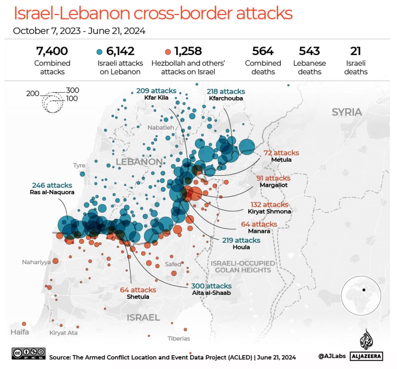
This has included artillery firing, rocket attacks, missiles, drones, and of most concern – air defense activations on both sides. Various instances of false identification have been reported.

This fighting has mostly been constrained. If a full-scale conflict develops as feared, things may get a lot worse.

In the skies

Just last month, Hezbollah reported targeting Israeli fighter jets using surface-to-air missiles for the first time. Existing airspace warnings for the OLBB/Beirut FIR do not any mention level restrictions.

There has been some credible concern recently that Hezbollah might possess more sophisticated surface-to-air weaponry. One report speculates this includes mobile Iranian made radar-guided SAMs which are capable of targeting aircraft as high as 90,000 feet with range of up to 100kms (depending on the variant).

Advanced surface-to-air missile range (100kms), as seen from a point along the Lebanese border.

The Wall Street Journal have also suggested another system may be present with similar capabilities supplied by Wagner Group mercenaries.

It is possible we have just not seen these types of weapons used by Hezbollah in this conflict to date.

While the LLLL/Tel Aviv FIR has arguably been a masterclass in how to maintain safe and informed overflights near a conflict zone in recent month, should a larger conflict arise it is unlikely the safety of civil aircraft in the OLBB/Beirut FIR will be protected to the same extent.

Existing Airspace Warnings

We maintain a Safe Airspace Risk Level of Two (Danger Exists) for the OLBB/Beirut FIR.

Here is a summary of existing state-issued airspace warnings for Lebanon:

  • Canada Operators should not enter the OLBB Beirut FIR at all levels due to risk of military activity. CZQX Notam H3476/24. New, July 29.
  • US FAA Exercise caution within 200nm of the Damascus FIR due to military activity. Possibility of GPS interference, communication jamming, and long-range surface to air missiles in the area. KICZ Notam A0009/18.
  • United Kingdom Caution to UK operators in the OLBB/Beirut FIR due to potential risk from military activity. EGTT Notam V0025/24.

Why have these warnings not been upgraded?

History has taught us that we need to be more responsive to airspace threats – a danger may exist or develop before states publish official airspace warnings or restrictions. And all of that takes time.

The events of the past days have happened quickly, and extensive diplomatic efforts are now underway to prevent a larger-scale conflict in the Middle East, but it remains to be seen if one can be avoided. We’re monitoring the situation closely – keep an eye on safeairspace.net for updates.


Teterboro: RIP the RUUDY SIX

For some time now, the problematic RUUDY 6 SID out of KTEB has been causing trouble. In fact, just prior to the pandemic the FAA reported it had resulted in nearly two hundred pilot violations in just six years.

If you’re not familiar with it, it is a departure from Runway 24. Here’s the chart:

The reason for the high number of deviations is cause for debate with both lateral and vertical excursions reported. In the case of the latter, one suggestion is that the procedure itself isn’t that clear. For instance, a typical IFR clearance out of TEB includes the phrase “climb via the SID.”

Take another look at the chart – it requires a level off at 1500’ and an instruction to maintain 2000’.

This can be interpreted in two different ways – either to maintain 1500’ until cleared to 2000’, OR to continue climb to 2000’ passing the waypoint WENTZ.

The Teterboro Users Group (TUG) since clarified the latter is correct, given there are actually three things going on at once:

  • A turn to WENTZ to separate aircraft on Newark’s 22L ILS above.
  • A level restriction at WENTZ to keep aircraft away from aircraft descending to 2500’ above.
  • Achieving the minimum vectoring altitude for the area – hence the subsequent climb to 2000.’

And all of this while managing the energy of high-performance business jets shortly after take-off into some of the busiest airspace in the world. There is little room to get things wrong.

But people were, and quite consistently. And so, work began to develop a clearer SID to replace the troublesome RUUDY.

Welcome Wentz.

On July 11 that finally happened with the publication of the new WENTZ ONE SID – almost.

The WENTZ ONE is effectively an improvement to remove the ambiguity. It does away with the step climb to 2000’, instead requiring aircraft using it to maintain the one level – 1500’.

ATC will issue any subsequent climb instruction.

Here’s what the new procedure looks like:

Here’s the kicker though, while the charts have been published, no one is flying it just yet. Why?

TUG explains that this is due to FAA controller training requirements, which are essential. Given the pending relocation of Newark’s airspace from NY TRACON to Philadelphia TRACON it is difficult to predict exactly when this process will be finished.

So, while the plate will appear in your EFB, expect the RUUDY SIX for a short while yet.

What about an instrument approach to Runway 01?

While we have you here – there is another problem pilots need to contend with at TEB.

An instrument approach to Runway 01, or lack thereof.

Right now, the common procedure is the ILS 06, circle-to-land 01 to keep you clear of Newark.

The challenging ILS 06, circle 01.

This approach is challenging for a number of reasons. If you’re not familiar with those, check out Code 7700’s full briefing here.

For some time now TUG has been advocating tirelessly for a proper RNAV approach which is long since overdue. There has been some progress for some Honeywell users. Since last year there has been a coded FMS visual approach that replicates the visual to Runway 01, but with lateral guidance and vertical guidance using familiar waypoints DANDY and TORBY. It does this with moderate angles of bank and a gentle 3.5 degree slope alleviating some of the existing threats of the procedure.

You can watch that approach below:

With regards to a publicly available instrument approach to KTEB’s 01, TUG advises we will need to wait a while longer yet. They will have a formal update for us later this year.


Don’t Climb! A Big NAT No-No

Last week, Gander Oceanic asked us to get the word out on this growing problem. More and more crews are getting this wrong, especially since OCR/RCL is starting to happen elsewhere on the ocean. The same issue is common on the other side of the pond, most frequently in the Shannon FIR.

What’s the problem?

Pilots climbing without a clearance.

Why would we do that?

Because we think we have a clearance.

OK, tell me more

When you get your Oceanic Clearance – or send your RCL, it contains an Oceanic Entry Point, Flight Level, and Speed. From that point, that’s what you should fly. But if you are currently at a different level to the Oceanic Cleared Flight Level, you have to ASK for the level change. That’s really all there is to it.

Oceanic Clearance is not a Domestic Clearance

Your Oceanic Clearance is valid only from the Oceanic Entry Point (OEP). Take this example.

ACA123 CLRD TO LFPG VIA NEEKO 54NO50W 56N040W 57N030W 57N020W PIKIL SOVED
FM NEEKO/1348 MNTN F330 M082

Your Oceanic Clearance commences at NEEKO. You must be at FL330 by the time you reach NEEKO, and then track to 54N50W.

But, if you’re still somewhere over Newfoundland at say FL320, you have to request higher from Gander Domestic ATC, before you climb to your Oceanic Level.

If you just decide to climb without asking, that’s where your day will start to go wrong.


Recent procedural changes to the NAT may also be compounding the problem, so let’s take a closer look.

Wait, I thought Oceanic Clearances on the NAT were a thing of the past?

Soon soon, but not yet. While Reykjavik and Santa Maria have removed oceanic clearances, Bodø, Gander and Shanwick are still targeting December 4 for the big switch. Until then, expect to receive a conventional oceanic clearance when approaching their airspace.

Oceanic Clearances

 You can read all about them in NAT OPS Bulletin 2020_001 Rev 1, but the crux of the issue is found in Section 5.3 (Clearance Delivery):

… The flight level contained in the ACARS data link oceanic clearance is the “cleared oceanic flight level” for the purposes of complying with the lost communication procedures detailed in State AIPs, ICAO Doc 7030 (North Atlantic Regional Supplementary Procedures) and NAT Doc 007. ATC is responsible for providing a clearance to enable the flight to reach this flight level before reaching the OEP. If there is a concern, flight crews should contact ATC…

They made this handy picture too:

 In other words, the flight level contained in the ACARS datalink oceanic clearance is NOT a clearance to climb (or descend). You need to request this with your active ATC.

Why is this becoming a problem again?

We can only speculate – Gander aren’t sure either. But we suspect the use of datalink, in addition to recent RCL changes may be the culprit. For instance, back in May, the automated response to an RCL message was changed (ironically to reduce any ambiguity). It now only reads “RCL Received by (ANSP).” In other words, the “fly current flight plan or as amended by ATC” bit was removed. A full oceanic clearance therefore contains more information, and the use of ambiguous phrasing such as ‘cleared level’ may be creating more confusion on the NAT than ever before.

Questions?

Comment below, or email the OPSGROUP Team for help!


South Korea Airspace Risk Update

Key Points
  • There are no official airspace warnings for South Korea, but the risk situation seems to be getting worse.
  • Airspace safety is gradually deteriorating due to several factors: GPS Interference, North Korean space launches and missile tests, military drills and failed agreements with North Korea, and weird balloon incidents.

If you’re operating in the RKRR/Incheon FIR, it is important to stay up to date with airspace risk.

In stark comparison to North Korean airspace, which is rife with warnings and flight prohibitions, operations over South Korea continue with almost no active advisories to crew – save for the odd FIR Notam.

It is not so much a matter of disinformation, but a lack of it that can create complacency amongst pilots operating there.

The situation on the Korean Peninsula is unique. The two nations are not at war but remain in a state of constant readiness to engage in one. They live in what was once described as a ‘reciprocal fear of surprise attack.’

This means South Korea’s airspace is at constant risk of instability caused by some kind of political crisis. Things have potential to change quickly, and without warning.

It is therefore vital to monitor changes in airspace that is considered by most to be completely safe. Here is a review of what has been happening in the RKRR/Incheon FIR lately that may have subtly been increasing risk to civil aircraft.

GPS Interference

The US FAA previously published a warning for GPS interference in South Korean airspace via a KICZ Notam – but this was cancelled back in 2018. The signs are that this advice may need to be re-visited.

On March 11, the RKRR/Incheon FIR issued a new warning advising extreme caution for GPS interference including the vicinity of RKSI/Incheon, Seoul. The nature of the interference wasn’t specified but was likely to have included spoofing.

RKRR Z0558/24 - CAUTIONARY INFO FOR ACFT OPERATING IN INCHEON FIR :
PILOTS HAVE REPORTED THAT GPS SIGNALS ARE UNRELIABLE OR LOST 
INTERMITTENTLY IN INCHEON FIR(AROUND INCHEON AND SEOUL AREA). 
EXERCISE EXTREME CAUTION WHEN USING GPS. 
10 JUN 05:51 2024 UNTIL 17 JUN 15:00 2024. 
CREATED: 10 JUN 05:51 2024

The source of the interference was suspected to be North Korea attempting to interfere with military drills in the area.

This was followed by an OPSGROUP member report of GPS interference during an approach to RKSS/Seoul on May 16:

“GPS spoofing into RKSS/Seoul [while] on approach to RWY 32R. We disabled hybrid and deselected GPS after seeing the risk reported on ATIS…”

Any kind of GPS interference, especially when operating in and out of Seoul, is cause for concern. It’s 20nm from the North Korean border and a bunch of prohibited areas which carry chart warnings that say in very clear language that you may get shot at if you inadvertently enter.

North Korea’s Race to Space

Late last year, North Korea surprised the world by launching a satellite into space creating a potential debris field in the Yellow Sea between South Korea and China. The launch prompted a missile warning in Southern Japan.

Unannounced North Korean space launches create airspace risks on a much wider scale than conventional missile tests.

Unlike conventional missile tests, space launches create hazards to aviation that extend far beyond the ZKKP/Pyongyang FIR rendering existing airspace warnings arguably inadequate. Here is an example of a warning hurriedly issued for large portions of the RKRR Incheon FIR following a previously attempted space launch.

Then just weeks ago, North Korea attempted to launch another (with no prior warning) which failed spectacularly in a mid-air explosion. This prompted South Korea to conduct air drills with over twenty military fighter jets near the demilitarised border zone.

North Korea have since announced to Japan their intention to try again with another potential debris field near the Korean Peninsula, and the Philippines Island of Luzon. The original target was June 4 but we’re still waiting.

Behind this persistence to have satellites in space is Pyongyang’s ability to gather intelligence on South Korea should a conflict escalate – it seems that risk to civil aviation is an afterthought.

Ballooning Tensions

Earlier this month, North Korea sent at least three and a half thousand balloons across the border into South Korea carrying animal excrement, garbage and scrap paper. Some landed in Seoul.

No flight disruptions were reported, but images circulating in the media show that the balloons were not small and could easily cause low level hazards to aircraft operating in South Korean airspace near the border.

Earlier this month, North Korea sent three and a half thousand of these balloons across the border into South Korean airspace – some landing near Seoul.

Failed Pact

On June 4, Seoul axed a six-year old agreement with Pyongyang that was designed to calm things down between the two countries. It hoped to achieve this by prohibiting provocative military drills or carrying out psychological warfare near the border.

Just two days later, joint drills with the US were carried out using a long-range bomber to drop precision-guided bombs over the Korean Peninsula. It was the first time this has happened in seven years.

Existing Airspace Warnings for South Korea

They’re extremely limited. The Incheon FIR routinely issues temporary ones by Notam, under the RKRR designator but these can be easily missed in briefing packages. There are no other state issued warnings or advisories to report.

Safe Airspace

Perhaps more concerning to airspace safety than a single large event (such as the outbreak of war) are situations where risk gradually deteriorates in open and busy airspace.

This is arguably what we are seeing right now over South Korea. All of these changes are reported on safeairspace.net – our conflict zone and risk database.

If you have more information to add to this briefing, we’d love to hear from you. You can reach us on team@ops.group.


SE Asia Monsoon Season: What Are LSWDs and Why Will They Cost You Fuel?

June marks the start of monsoon season throughout Southeast Asia. From now until October, enroute weather deviations will routinely exceed 100nm.

This creates a significant challenge for controllers and coordination between the high number of FIRs that span congested air corridors between Taiwan, Hong Kong, Singapore and Indonesia.

To make matters worse, the 2024 Monsoon season is predicted to be a bad one.

And so, the answer is something called Large Scale Weather Deviation Procedures (LSWD) already innocuously appearing in FIR Notams like the one below.

This raises two important questions:

  • What does LSWD actually mean?
  • What are operators doing about it?

In a nutshell, your standard contingency allowance may no longer be enough – meaning unfamiliar operators (especially on fuel critical routes) may unexpectedly be caught with their pants down.

So, let’s take a closer look.

The 2024 monsoon season is going to be bad.

The clever folk at the World Meteorological Organization recently said so.

Last year, in comparison, was weak.

You can take a look at their full report here, but the short story is that thanks to a spicy combination of ‘ninas and ninos’ much of Southeast Asia is about to receive up to ninety percent of its annual rainfall in the next few months. Which means large scale build-ups will be everywhere.

The airspace picture.

Spanning this area of unstable weather is a large number of adjacent FIRs serving some of the busiest air corridors in the world.

Take this routing (WADD/Bali to VHHH/Hong Kong) as an example, overlaid with current precipitation in the region. It’s very early days, but you can already begin to see the extent of the deviations FIRs are dealing with.

The sheer scale of weather deviations required by aircraft in this area creates a major challenge for air traffic control.

The lateral separation between adjacent airways is often far less than the deviation each aircraft will require, along with the narrower vertical margins of RVSM airspace.

This creates numerous problems for controllers – providing priority handling to one aircraft creates delays and disruptions for others. It’s your standard ripple effect.

To create room, ATC has specific protocols to manage these deviations. They call them LSWDs and they are used to reign in the mess.

How do these procedures work?

Traffic will be processed through a limited number of routes with level restrictions bound by their direction of flight. These routes can be found in each state’s respective AIPs.

Here’s an example found buried in Singapore’s docs:

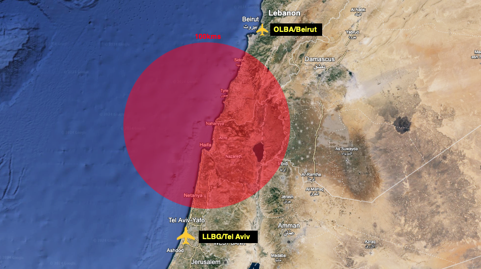
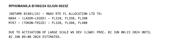
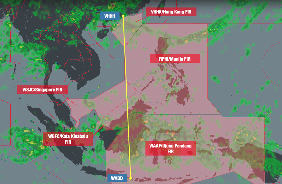
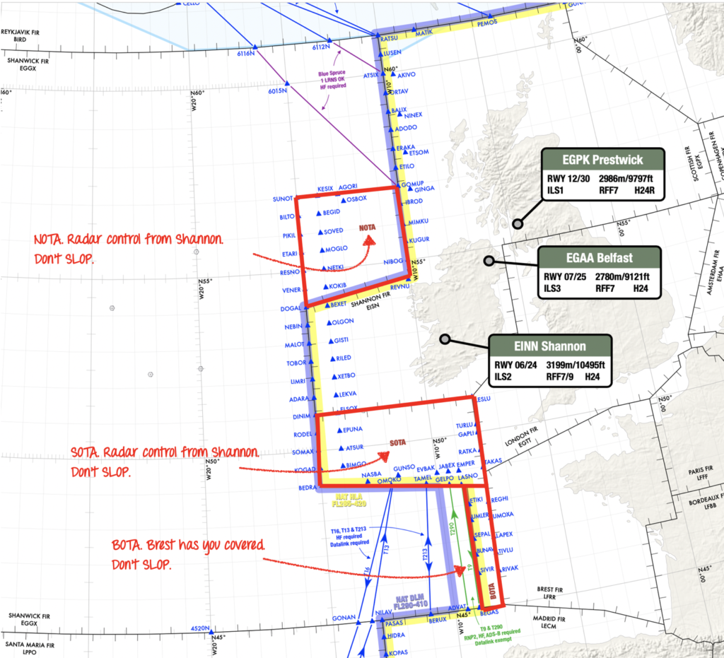
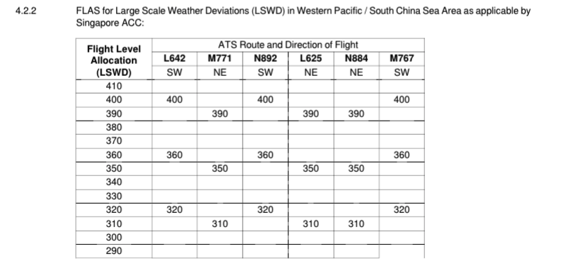
To make co-ordination easier between the numerous ATS sectors, all traffic operates with the same level availability whenever LSWDs are active.

For business jets, this may become problematic as higher flight levels (FL400+) may not be available for extended periods of time.

As a locally-based G550 Captain explains:

“Even if higher flight levels are available in one FIR, controllers may be reluctant to give them to you. This is because there is no guarantee that the next sector can accommodate it and it can be hard to get you down again…

 …The main thing with LSWD is knowing that a lot of levels we usually get won’t be available. And so, we carry more fuel accordingly. It may also be worth briefing the pax that conditions may be bumpier than they’re used to…”

Flow control and crossing time restrictions are also common which may mean the use of less efficient mach numbers.

This can also lead to delays for start-up clearances due to enroute spacing. When asked what additional fuel our local G550 Captain carries for these procedures, his answer was this – “at least thirty minutes.”

Have more to add?

Local operator feedback is invaluable to everyone in the group. If you’ve got anything to add to this article, get in touch with us at team@ops.group


Argentina: Overflight Permits Now Required

Key Points
  • Effective March 13, all foreign aircraft now need an overflight permit when transiting Argentinian airspace.
  • There’s been no change to landing permit requirements: private flights don’t need one, all other flights do (including tech stops).
  • AI is still not great at making images with planes or handshakes in them 😂

AIP SUP 32/2024 has been published with all the new requirements – but here’s a quick summary of what you need to know.

Airspace Affected

This change applies to all Argentinian airspace, namely the:

  • SAVF/Comodoro Rivadavia FIR
  • SAEF/Ezeiza FIR
  • SACF/Cordoba FIR
  • SARR/Resisitencia FIR
  • SAMF/Mendoza FIR

How to apply

You’ll need to provide at least 72 hours’ notice.

Send your application to the National Administration of Civil Aviation (ANAC)’s AFTN address SABAYAYX, and via email to ovf@anac.gob.ar (also cc. in interaerodromosbis@gmail.com). For emails, use the subject line ‘Application for Overflying the Argentine Territory.’

If you need to give ANAC a call, you can also reach them on +54 11 5941 3000.

Private operators will need to provide copies of two documents:

  • Certificate of airworthiness
  • Proof of insurance

Commercial operators also need to provide an air operator certificate.

Important: It may sound obvious, but they are quite specific about it. Don’t assume you have been granted a permit until you have specifically heard back from them.

Exemptions to the 72-hour rule

You can only get around this if you are operating an essential flight. This basically means SAR, humanitarian, air ambulance or firefighting ops.

What about landing permits?

Nothing has changed! Private flights don’t need one – but make sure you include your company name, physical address and contact info (tel, email, AFTN etc) in the RMKS section of your flight plans.

All other flights (including tech stops) must obtain one.

Need help with other permits?

OPSGROUP members have access to the Permit Helper, found under ‘Apps’ in your Member’s Dashboard. Just search for the country you are planning to visit to see current overflight and landing permit requirements.

You can also reach out to the team (and other members) via the Slack channels, or email us team@ops.group.


Why do we see US Military Notams?

Back in March, an OPSGROUP member reached out to us after the following Notam appeared in their flight plan briefing package.

As EGKB/Biggin Hill (UK) was their filed alternate, the Notam was of some interest. A quick email to the airport authority confirmed that the ILS was fully serviceable and available.

The member contacted Jeppesen directly about the Notam, and here was their response:

“The Notam in question is actually a US DOD procedural Notam which only applies to US military pilots and those flying under contract/partnership with the DOD. So, while the tower may confirm that the approach is in-service, the US military is not authorized to fly it for reasons known only to them…”

The following questions remained:

• Why are we seeing these Notams in the first place?

• What is the reason for the restriction on military aircraft?

The short answer is that the response from Jeppesen was correct – but could use a little more explanation.

Where we get our Notams from.

There are two primary “original” sources for Notams around the world:

  1. The European AIS Database (EAD) – run by Eurocontrol
  2. The US DoD (Department of Defense). It supplies Notams to the FAA for their ‘Notam Search’ app, and their SWIM feeds – the FAA’s information-sharing platform.

If your flight plan package is sourcing Notams from the US DoD (and not being filtered correctly), you will see military Notams included – like the one above. Think of them like company notams, for internal use. In this sense, they are not ‘true’ Notams and shoud be completely disregarded by civilian operators.

But why the UK?

To use the DoD Notam feed correctly, military Notams need to be filtered out. But there may be more to it than that.

You’ll see the EGKB Notam above has a ‘V’ designator.

In the UK ‘V’ series Notams mean the following:

“Notification of Security Advice to UK Air Operators by Government to provide guidance/instructions on Airspace Security Risks. Volcanic Ash related information within En-Route Airspace London FIR/UIR, Scottish FIR/UIR, Shannon FIR/UIR and Shanwick Oceanic FIR…”

In the US, they mean something different:

“A NOTAM information pertaining to a location’s published instrument procedures, i.e., Standard Instrument Approach Procedure (SIAPs), Standard Instrument Departure (SIDs), Departure Procedures (DPs). These NOTAMs shall be published under the direction of TERPS personnel…”

Which is why in this case (and many others) we may still see these Notams find their way into our briefing packs.

In a Notam-tale as old as time: just because they’re there, doesn’t mean they’re relevant. The potential for confusion holds strong – especially if civilian operators misinterpret Notams never meant for them in the first place.

Why does the military have their own restrictions?

Because they do! In the same sense one airline can do something another does not allow.

Common sense indicates that the way military aircraft are operated differs substantially from civilian aircraft – and that the margins and procedures designed for us do not necessarily work in the same way for them.

Have more info?

If you have something you’d like to add to this article, we’d love to hear from you. You can reach us at team@ops.group.


Saudi Arabia Overflights – Free Route Gotcha

Key Points
  • The Southeastern section of the OEJD/Jeddah FIR is now Free Route Airspace.
  • It’s not straightforward. New procedures have been published in the Saudi AIP.
  • If your flight plan does not comply, you are likely to be instructed to descend below FL300.

Background

We’ve received a new report from an OPSGROUP member after a recent run-in with ATC in the OEJD/Jeddah FIR.

The problem stemmed from a small (and confusing) change that became effective on April 18.

Essentially, ATC were upset that their filed route did not comply with newly published Free Route Airspace (FRA) procedures buried deep within the bowels of the Saudi AIP.

The fallout of non-compliance is the ATC equivalent to the ‘naughty corner’ with aircraft directed to descend below FL300 for the duration of their crossing of the affected airspace.

In this case, the member was able to negotiate to remain at their preferred level but not before a fair amount of head scratching as to why they got in trouble in the first place.

As large amounts of traffic are now transiting Saudi Arabia to avoid Iran further north, it is especially relevant right now.

New Free Route Airspace

On April 18, a large chunk of Southeastern Saudi Arabia (known as the SE Sector) became Free Route Airspace (FRA).

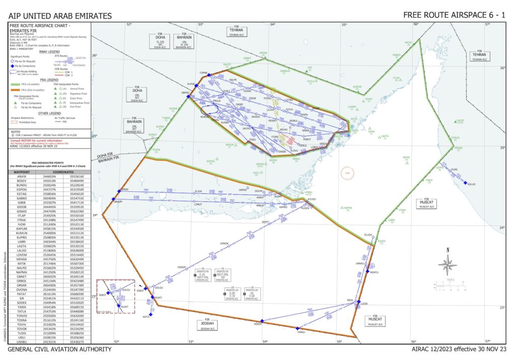
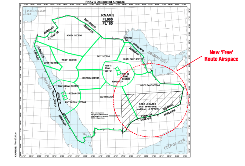
Typically, FRA means that pilots can freely plan any route they like between defined entry and exit points without reference to the ATS route network. This saves both money and time – simple.

However, this is where things get hazy.

The change was notified in this easily overlooked FIR Notam:

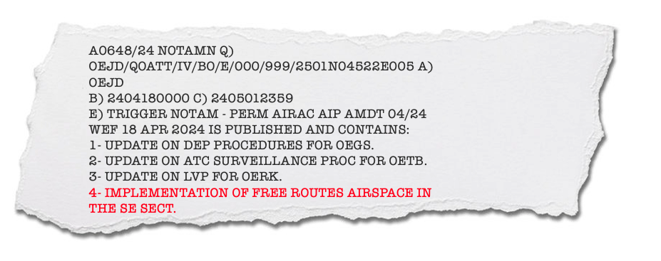
This directs you to the Saudi AIP. This is great if you have a spare half an hour to prove who you are, download a special app and access it. To save you the trouble, the relevant bit is ENR 2.2.4 which you can find here.

Click for PDF.

Here’s the kicker – it’s Free Route Airspace, but not really. You still need to plan and file via the standard routes found via the link above.

In other words – ‘fly whatever route you like, as long as it is one of these ones.’

Turns out if you don’t, they will want you out of the ‘FRA’ which means a descent below FL300 (or a climb above FL600 if you’re piloting the Space Shuttle).

Keep listening out.

There are also some really specific comms requirements you need to follow along each route as the sector is controlled by several VHF frequencies. It seems you cannot rely on ATC to tell you when to switch.

“Normal” routes.

Don’t forget the Free Route Airspace only applies to the SE Sector of the Jeddah FIR. Everywhere else in Saudi airspace, you’ll need to follow “normal” ATS routes as per usual.

But even these “normal” routes are a pain. Saudi Arabia (like many other countries in the region) has preferred routes depending on where you’re flying from/to – so you’ll need to make sure you file on one of these. For some reason Jeppesen recently stopped publishing them, so now you have to get them from (yes, you guessed it) the Saudi AIP! SUP 8/24 talks about it. You basically download this Route Availability Doc and work out a route from there.

Other Free Route Airspace in the region.

Qatar and the UAE are the only other countries in the Middle East that have implemented FRA, and unlike Saudi Arabia, both seem fairly straightforward.

Qatar – has implemented a corridor of FRA straight through the middle of the OTDF/Doha FIR, available from FL275-460. The Qatar AIP does not currently list any restrictions on its use.

Click for PDF.

The UAE – has implemented FRA in parts of the OMAE/Emirates FIR from FL355-600 – basically the parts around all the airports, and the airspace connecting with the OOMM/Muscat and OIIX/Tehran FIRs. Like Qatar, the UAE AIP does not currently list any restrictions on its use.

Click for PDF.

Please report back.

Thank you to the member who got in touch.

These changes can be hard to spot. Especially when you pay an operational penalty for procedures like this one that are poorly written, hard to find, or obscure.

We need your help to spread the word whenever you come across something different – in Saudi Arabia or elsewhere. Thousands of other like-minded pilots will thank you later.

If you have something you’d like to share, you can reach us on team@ops.group. We’d love to hear from you.


TIBA in Australia: What’s Going On?

Key Points
  • TIBA still seems to be an issue in Australia – shortage of ATC resulting in big bits of restricted Class G airspace, often at short notice.
  • We wrote about this last year, including guidance on what to do (see updated post below), but now IFALPA have published a Safety Bulletin saying the problem is still ongoing.
  • Amid accusations of understaffing, Australian ATC has announced they intend to strike. This process will take a few weeks to action, and so we’ll likely see disruptions from May. This may include full 24hr work stoppages and will be notified in advance via the YMMM/Melbourne and YBBB/Brisbane FIR Notams.

Since early in 2023, we’ve seen large sections of restricted TIBA airspace (traffic information broadcasts by aircraft) established by Notam up Australia’s East Coast in both the YMMM/Melbourne and YBBB/Brisbane FIRs.

In fact, there were 340 instances of uncontrolled airspace between June 2022 and April 2023 alone. And it’s still happening.

The cause here appears to be a fundamental shortage of air traffic controllers.

Where has this been happening?

In the South, look out for TIBA airspace east of YSCB/Canberra airport, Australia’s capital city found inland from Sydney.

Further north there has been a greater effect as large portions of coastal airspace near YBCG/Gold Coast and YBTL/Townsville airports have been impacted. This is an extremely busy air corridor – 80% of Australia’s population live on the East Coast.

At the top end of Australia, YPDN/Darwin airport has also been affected which can result in re-routes for international traffic headed up into South-East Asia and beyond.

Here’s what those hotspots look like on a map:

TIBA airspace has been reported in or near these hotspots.

It’s not all the time.

TIBA airspace is being activated by Notam, typically for hours at a time. A look at today’s batch indicated all is ops-normal. However, a local airline captain has advised OPSGROUP that it is currently a frequent occurrence.

Broadcast, or avoid?

The vast majority of airline traffic appear to be avoiding the TIBA airspace. This typically involves less direct routes at the expense of delays and fuel. Helpfully, for major city pairings the NOTAMs contain suggested routes that will keep you clear. But expect SIDs or STARs you may be less familiar with.

In fact, major carriers have policies in place that prevent them from using TIBA airspace anyway – unless they happen to be in it when it is activated.

That’s not to say there won’t be other traffic taking advantage of the more advantageous routes though. The East Coast is characterised by a huge variety of traffic including charter, skydiving, medevac and survey all of which may have valid reasons for using TIBA.

It can still be used safely, but with the procedures below (a heads up: dual comms are a requirement).

How on earth do I ‘do TIBA’?

First things first. Whatever you do, don’t enter without permission. Australia’s TIBA airspace is typically restricted – in the sense you will need PPR to use it. The relevant Notams are quite helpful, and provide all the information on how to get it. Here’s an example.

Your approval will typically involve a phone call beforehand, and a chat to a flight information service in adjacent airspace for traffic information.

Once you’re in, you are totally responsible for terrain and collision avoidance. Turn that radio up and make sure you’re both alert and monitoring both the TIBA frequency and the relevant ATS one – now is not the time for controlled rest. Whoever is on the radios is going to be busy.

The Australian AIP then takes over. You can find the procedures in full here (time saver: flick to ENR 1.1-91). We’ve also put together a summary of those in this handy little briefing card which may be useful to keep in your flight bag:

OPSGROUP members: click to download hi-res PDF.

Other questions?

You can also get in touch with CASA via this link, or alternatively Airservices Australia here with questions. Both have been very helpful in answering our pesky conundrums in the past.


Airport Fire Fighter Strike in Australia

Disruption looms at Australian airports on April 15. Rescue fire fighters have announced a four-hour strike from 06:00 – 10:00 local time at twenty-seven airports across the country – including the majors.

It seems the cause extends beyond just pay and conditions with safety concerns over staffing levels the United Fire Fighters Union has described as ‘dire.’

Here’s everything we know, and how to decode the inevitable RFFS Notams soon to grace your pre-flight briefing.

Impact to Ops

The strike will see RFFS categories simultaneously reduce as low as zero (more on these categories below).

While the exact impact of the impending strike isn’t clear yet, previous strikes have given us a good idea of what to expect.

Traffic delays could extend beyond the strike period as airlines scramble to re-schedule cancelled or delayed services, with the added addition of peak school holidays. For inbound traffic this means delays and holding.

The RFFS downgrades themselves will be announced by Notam closer to the time and may also affect the use of Australian airports as ETOPS alternates.

‘Leaked’ Controversy

The plot thickens over the alleged leaking of a safety assessment which supposedly identified major flaws at several Australian airports over a lack of staff, procedures, trucks and other frontline fire-fighting equipment for the type of aircraft using them.

If this is correct, YBBN/Brisbane, YPPH/Perth, YMML/Melbourne, YSCB/Canberra and YSSY/Sydney airports are all operating at high levels of risk in some emergency scenarios – something that Air Services Australia (who is responsible for RFFS staffing) has denied. The Australian Aviation Authority (CASA) has also weighed in on the issue, and sides with Air Services.

The Fire Fighter Union has also claimed that in some cases, flights have been operating at regional airports (such as YMLT/Launceston and YBSU/Sunshine Coast) with less than the minimum required RFFS staff on watch – although we can’t confirm this.

Regardless of who is correct, the two parties are locked in a row that has led to the upcoming strike.

RFFS Categories

The effect of the strike will become apparent in the next couple of weeks via Notams like this:

If you’re not familiar with what these categories actually mean, here’s a quick rundown on how they work.

An airport’s RFFS Category refers to the largest aircraft it is intended to receive (think length and fuselage diameter).

This dictates the amount of water, agents, vehicles and response time required to fight fires on planes of these size.

With that in mind, here are the current ICAO RFFS Categories.

Further Strikes Are Likely

Right now, April 15 is the only scheduled RFFS strike. However, if no deal is struck between the Fire Fighters’ Union and Air Services Australia, we are likely to see more.

The good news is that we all also receive advance notice of any that are planned. We’ll continue to report those as they arise.

If you encounter disruptions during the upcoming strike, we’d love to hear from you. You can reach us on news@ops.group.


New FAA Approach Warning for Aspen

Key Points
  • Be careful to select and fly the correct LOC approach at KASE/Aspen – there are two. The normal public use one is the ‘LOC-DME-E.’ The second is the ‘SPECIAL LOC-DME RWY 15’ which requires approval to fly.
  • Some FMS systems have both in their databases which is causing confusion.
  • There are some safety-critical differences between the two so make sure you shoot the right one.

The FAA has put out a new Letter to Airmen with a warning for ops at Aspen.

There are two localiser approaches available which is causing potentially safety-critical confusion.

The primary (public use) approach is the LOC-DME E. The second is the SPECIAL LOC-DME RUNWAY 15 which requires prior approval via an LOA from FAA Flight Standards.

Many FMS systems have both in their database, and it’s not always crystal clear which is the correct one to select:

Typical FMS approach selection – which would you have chosen?

The notice goes on to explain that there are some really important differences between the two which could lead to pilots accidentally busting crossing heights or minimums and losing safe separation from terrain.

As arguably one of the most challenging airports in the US, it’s important to get it right.

What’s the difference?

The first is the minima. If your ride is a CAT C for instance, the standard ‘E’ approach will get you down to 3122’ AGL.

The ‘SPECIAL’ approach gets you lower – up to two grand closer to terra firma. Extra simulator training is required to make this possible. This includes the next big difference – changes to the way missed approaches must be flown.

Some operator-versions of this approach include an ’emergency extraction procedure’ for go-arounds beyond the missed approach point for instance.

…Not unlike an emergency extraction at the dentist, things are going to get white knuckle if you haven’t received the proper training first.

Get the proper training before you attempt an emergency extraction.

And finally, there is the time of day – the publicly available ‘E’ approach cannot be flown at night. In some cases, the special can with the right paperwork.

The standard ‘E’ approach will be advertised and offered by default when the localiser approach is in use. Here’s what it looks like:

The LOA

If you’re seeking an approval to actually use the SPECIAL LOC approach, you’ll need to obtain an OpSpec C081 special authorisation like the one below. This will include Aspen specific training for all operating crew.

If you’d like to know more about this process, the NBAA has published this doc which is worth a read.

Have More Info?

We’re always on the lookout for intel from pilots out there. If you’re familiar with KASE and would like to add to this article, please get in touch with us on team@ops.group. We’d love to hear from you.


US: Total Solar Eclipse Incoming

Key Points
  • On the afternoon of April 8, a total solar eclipse will be visible across a large portion of Mexico, the US and Canada.
  • If you’re lucky enough to be flying, it may be a once-in-a-career type thing. The next one won’t happen in the US again until 2044.
  • There will be some impact on flight ops too. The FAA has published a list of airports on either side of the eclipse track, along with guidance on what flights in the area should expect on the day – check it here.

What’s so special about this one?

It is ‘total’ – in other words, the moon will pass directly between the sun and earth completely blocking the face of the sun. The sky will darken as though it were night (or very close to it). The sun’s outer atmosphere will become visible as a halo.

This ‘path of totality’ as it were, will begin over the South Pacific before hitting Mexico’s Pacific Coast at around 11:07 PDT.

From there it will enter the US over Texas, and travel across Oklahoma, Arkansas, Missouri, Illinois, Kentucky, Indiana, Ohio, Pennsylvania, New York, Vermont, New Hampshire and Maine.

Click for high-res version.

Across the border it will then be visible in Canada over Southern Ontario, Quebec, New Brunswick, Prince Edward Island and Cape Breton.

The show will end east of Newfoundland at 17:16 NDT.

In each instance complete totality will last for approximately 4 minutes. However, depending on your direction of flight, this may be longer in the air.

Here are the exact timings NASA has published for each region:

Don’t stare at the big shiny light!

It may go without saying, but be careful of your eyes. If the sun is anything but completely obscured, peering at it through a camera, telescope or your eyes will fry your corneas without appropriate protection. This will cause problems when it comes time to land again.

Your trusty Ray Bans won’t do it either – NASA says that sunglasses aren’t enough. You’ll either need to source yourself some funky eclipse glasses (which are thousands of times darker), a handheld solar viewer or use an ‘indirect’ viewing method.

If you’re flying in the afternoon on April 8, pick yourself up a pair of these bad boys for your flight bag.

Sidenote – don’t stare at it through a hole in a piece of cardboard either. No idea why, but this is what springs to mind to many. You’ll simply blind yourself through a very small hole. NASA have said no-bueno to that idea too.

Busy GA Traffic

Aside from a great view, an influx of traffic to GA-friendly airports is expected along the eclipse’s path. It’s a relatively narrow band of the most premium viewing (130nm wide) and so people will be travelling far and wide to get a good view.

As such, expect ATC-related delays and parking restrictions at larger airports along its path. It’d be worth checking ahead with your handling agent to ensure there will be no impact to your operation.

The FAA has published a list of airports on either side of the eclipse track – check it here.

If you’re headed into un-towered fields in something fast and fancy be aware you are likely to encounter more traffic than usual. Some of it will be transient and potentially not as proficient at being seen and heard as commercial operators are.

Gram Famous

Chances are you’ll want to take a picture of the eclipse with your smart phone. Here is a handy article with some tips to how to set up your camera and get the best results.

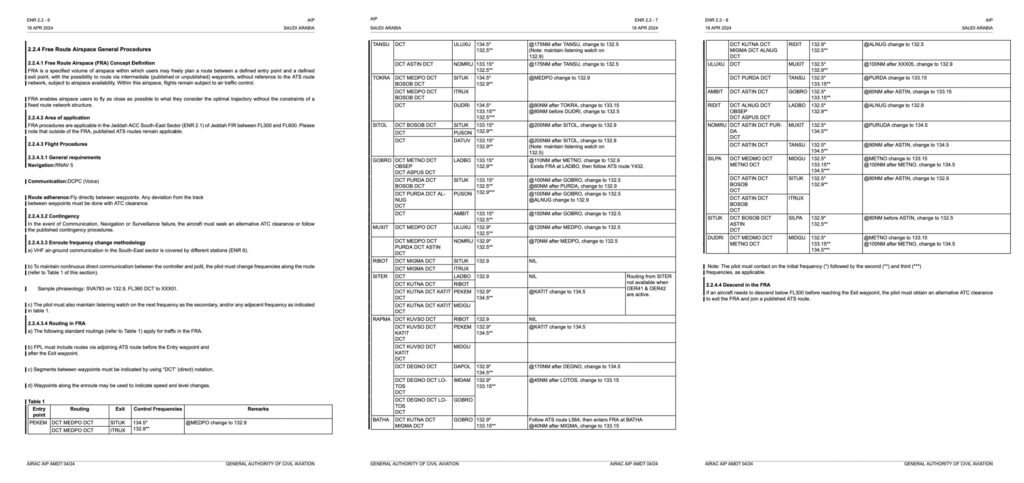
Better yet, share them with us on team@ops.group. We’d love to see them and show the rest of the group.

More Info

NASA has everything else you need to know about the eclipse on their website here.


Haiti Crisis: Airport Attacked, Aircraft Shot

Key Points
  • Worsening gang violence in Haiti. A state of emergency is now in place, and the US Embassy has issued a new warning for its citizens to leave immediately.
  • Aviation has also come under direct threat, with reports of several armed attacks at MTPP/Port-au-Prince in recent days. All flights have been cancelled until further notice and the airport is now effectively closed.
  • There are no official airspace warning for Haiti. However, conditions on the ground have been likened to an active war zone. For flights, normal services are unlikely to be available, and crew security cannot be guaranteed.

Airport Attacks

On March 4, several dozen heavily armed gang members attempted to take control of MTPP/Port-au-Prince airport.

They breached the airport perimeter and exchanged machine gun fire with police but ultimately failed. Airport staff were forced into hiding. Soldiers have since been stationed there for protection.

Since then, all flights have been cancelled.

This followed a separate attack last week where an A321 was damaged by a bullet after landing. Sustained gun fire was reported along the access road to the airport during this time.

A landing A321 at Port-au-Prince was apparently damaged by gunfire after landing on Feb 29.

Don’t look to the MTPP Notams for help – you won’t find anything. However, the media has reported several closures of the airport in recent days in light of these events.

Gangs are fighting fiercely for resources and revenue. This includes control over key transport routes hindering freedom of movement and further empowering the gangs – which is why the airport is being actively targeted. Gangs may also have the additional political motivation to interfere with ops at the airport in an attempt to stop the existing president from being able to re-enter the country.

State of Emergency

The Haitian Government declared a state of emergency on March 3, which will apply until further notice. On the same day, the US Embassy issued its own warning asking citizens to leave. 

The Embassy itself is periodically closing, and its staff are highly unlikely to be able to help anyone who finds themselves in trouble.

Machine gun fire has been reported near the US Embassy in Port-au-Prince

Impact on Overflights

The FAA does not currently have any active airspace warnings in place for Haiti.

The country operates its own small chunk of airspace – the MTEG/Port-au-Prince FIR. Adjacent sectors include Cuban, Dominican Republic and US airspace. Its Notams are also conspicuously quiet.

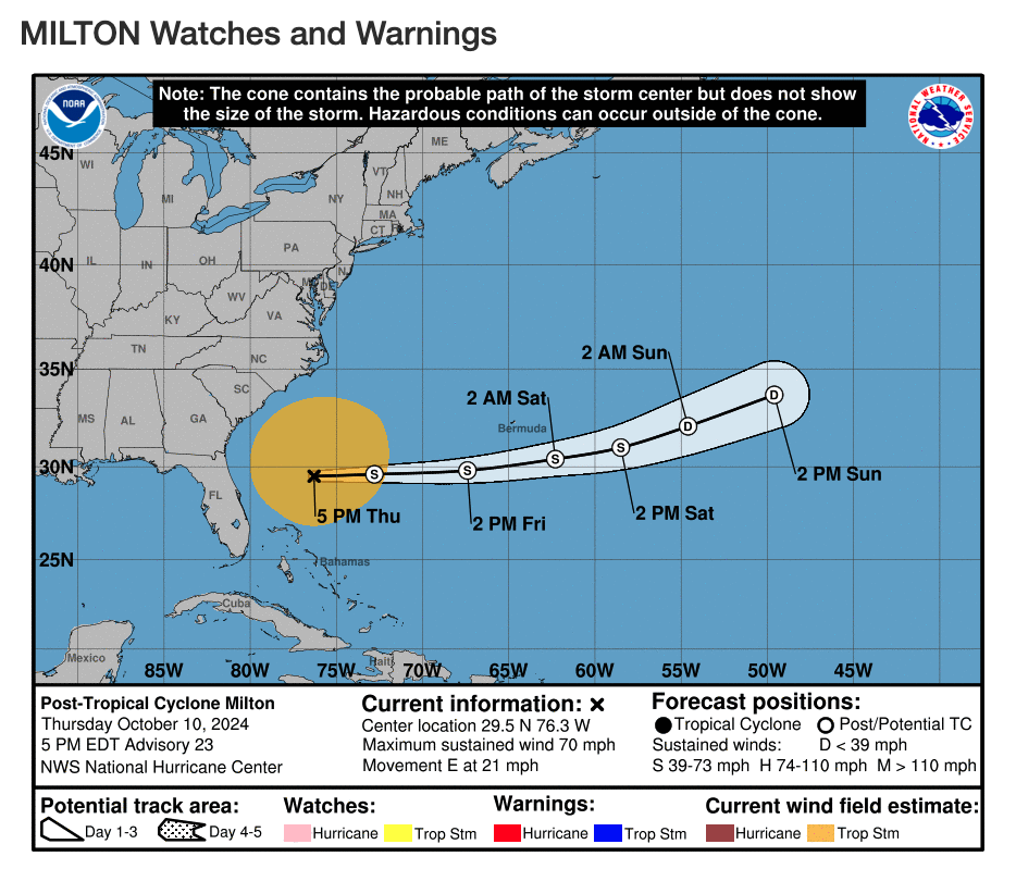
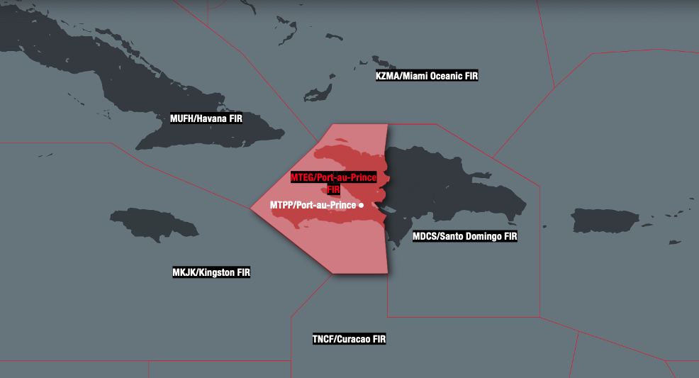
No restrictions on overflights have been published, with flight tracking still showing sporadic airline traffic overflying– although the bulk appear to be transiting further east over the Dominican Republic.

The Dominican Republic has banned all passenger and cargo flights to and from airports in Haiti (MDCS Notam A0111/24 refers), but this does not restrict overflights.

The gangs however have shown an active intent to target government infrastructure – its not clear yet what effect this may have on controllers’ ability to perform their duties at short notice.

At the very least, a solid contingency should be in place right now for a short notice reversion to Class G.

Special care also needs to be taken for the possibility of unplanned landings or diversions – especially to Port-au-Prince. Normal services are unlikely to be available, and crew security cannot be guaranteed.

As the situation evolves, keep an eye out for updated information from aviation authorities such as the FAA who may publish background information or additional flight restrictions.

We will report any we see on our conflict zone and risk database, safeairspace.net.

If you have any other information you’d like to share with us, don’t hesitate to get in touch via news@ops.group.


Delays and Diversions in Dubai

An OPSGROUP member reported that on Feb 21, several long-haul carriers were forced to divert due to extended airborne delays.

The problem stemmed from the following unassuming needle-in-a-haystack Notam…

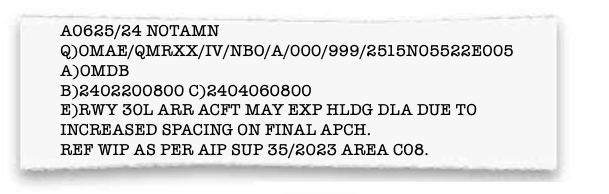
 It was later re-issued (after-the-fact), somewhat sheepishly with an actual holding advisory …

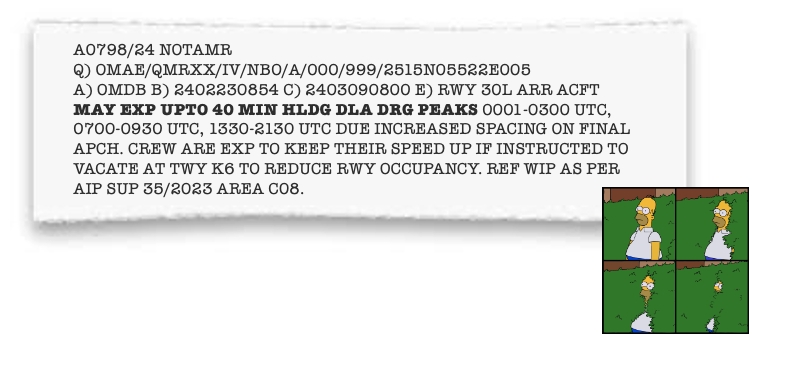
The good news is that you can easily access the referenced AIP SUP online – provided you provide scans of your passport, your contact details, favourite colour, hobbies and the name of your first-born.

OR

You can just read the following summary of what’s been going on.

The Trouble SUP

You can read it in full here (but it’s heavy).

Basically, what you need to know is that there are ongoing taxiway works happening at the airport.

These are divided into areas, and the one causing issues is ‘C08’.

For Runway 30L, this is causing a bottle neck for aircraft exiting on the rapids bound for terminals 2 and 3.

The preferred exit (K8) is partially blocked by the works, along with the next non-rapid exit (K7) which is completely closed.

The next option is K6, which is further up the runway. The extra time needed to allow aircraft to vacate means increased spacing for arrivals. Word on the street is that frequent A380 ops are also compounding the problem.

Here’s what that looks like on a chart.

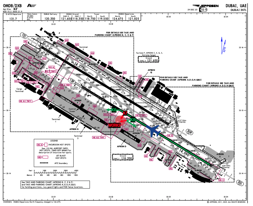
During peak times, arrivals are stacking up.

Those times are daily between:

  • 00:00 – 03:00z (04:00 – 07:00 LT)
  • 07:00 – 09:30z (11:00 – 13:30 LT)
  • 13:30 – 21:30z (17:30 – 01:30 LT)

If Runway 30L is in use, and you are arriving during one of these periods – carry at least an extra 40 minutes of holding fuel.

How long will this last?

The current Notam says until March 9, but may get extended. The SUP doesn’t provide an end date, and strangely the original Notam applied until April 6. In other words, your guess is as good as ours…

But wait, there’s more.

There are some other Notams hidden in the pile that include closures of the other runway (12L/30R) that infringe these times. That’s an average of seventy-five arrivals and departures per hour using the one problem runway – 40 minutes may still not be enough.

Please report back.

If you experience delays in Dubai related to works (or otherwise) we’d love to hear from you so we can share that info with the group. You can reach us on news@ops.group around the clock.