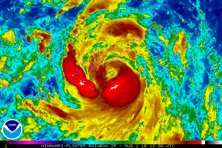
Typhoon Nida is enroute to Hong Kong, and will make landfall early on Tuesday morning. Now, we know that The Weather Channel and other mass media outlets enjoy exaggerating the picture somewhat, but the below NOAA graphic seems disproportionate as well.
With forecast average winds of around 40 knots (that’s a wet Wednesday in Ireland), and maximum maybe 70 knots – the impending doom depicted in the graphic below seems overstated. Has NOAA fallen victim to sensationalism? We wonder.
More on the topic:
- More: New APIS system coming to Hong Kong
- More: Seven things about Hong Kong
- More: Hong Kong: New Runway Opening
- More: Hong Kong: King of the Airports
- More: Hong Kong revised entry rules for flight crew
More reading:
- Latest: Gander’s Bringing Back CPDLC Oceanic Reroutes
- Latest: EU Temporary Admission of Aircraft – Busting Myths
- Latest: US Ops Update: Speeds, Squawks and Slippery Runways
- Safe Airspace: Risk Database
- Weekly Ops Bulletin: Subscribe
- Membership plans: Why join OPSGROUP?


The graphic posted below your paragraph is a loop image of IR satellite that illustrates cloud tops via means of temperature readings. It isn’t possible to sensationalize a satellite image unless using an errant scale. For NOAA, this would be criminal, obviously, as they are a free, government service.
This type graphic is very important to pilots to locate high cloud tops, which can redirect traffic and help identify worst regions of weather.
Please be careful with the wording of your briefings when it’s clear that the posted graphic is not well understood.