Tropical Storm Ian, which impacted Florida as a hurricane on Wednesday, is gaining new strength as it approaches South Carolina today. Forecasts say landfall could take place this afternoon.
The entire coast of South Carolina is under a hurricane warning. Once it makes landfall, Ian is expected to weaken back to a tropical storm as it makes its way across the southeastern US.
Meanwhile, Florida is still assessing the mass of damage from Ian, mostly from flooding.
National Hurricane Center’s Advisory, issued 1200z Sep 30:
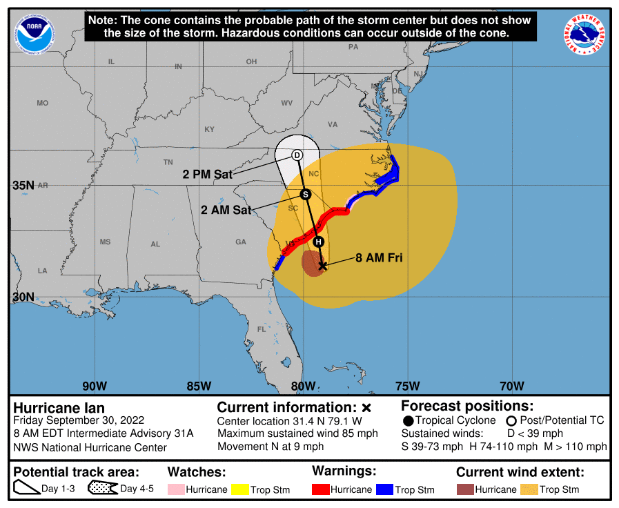
At 800 AM EDT (1200 UTC), the center of Hurricane Ian was located
near latitude 31.4 North, longitude 79.1 West. Ian is moving toward
the north near 9 mph (15 km/h). This general motion with an
increase in forward speed is expected this morning, followed by a
turn toward the north-northwest by tonight. On the forecast track,
the center of Ian will approach and reach the coast of South
Carolina today, and then move farther inland across eastern South
Carolina and central North Carolina tonight and Saturday.

Maximum sustained winds remain near 85 mph (140 km/h) with higher
gusts. Little change in strength is expected before Ian reaches the
coast later today. Rapid weakening is expected after landfall, and
Ian is forecast to become an extratropical low over North Carolina
tonight or on Saturday. The low is then expected to dissipate by
Saturday night.

Hurricane-force winds extend outward up to 70 miles (110 km) from
the center and tropical-storm-force winds extend outward up to 485
miles (780 km). A sustained wind of 40 mph (65 km/h) and a gust to
58 mph (93 km/h) were recently reported at a WeatherFlow
station on Fort Sumter Range Front Light in South Carolina.

The estimated minimum central pressure is 984 mb (29.06 inches).
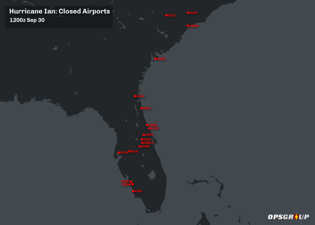
Airport Closures
Several airports across the region have closed for the passage of the storm. Here are the ones we know about as of 1200z on Sep 30:
 And here are the Notams that carry the announcements of the closures:
KAPF
09/097 – AD AP CLSD EXC 2HR PPR 239-564-1692. 30 SEP 12:00 2022 UNTIL 03 OCT 23:00 2022. CREATED: 29 SEP 22:04 2022
09/096 – AD AP CLSD DLY SS-SR. 30 SEP 23:00 2022 UNTIL 04 OCT 12:00 2022. CREATED: 29 SEP 21:56 2022
KRSW
09/112 (A0845/22) – AD AP CLSD EXC HUM 30MIN PPR 239-590-4460. 29 SEP 13:18 2022 UNTIL 07 OCT 16:00 2022. CREATED: 29 SEP 13:19 2022
KFMY
09/075 (A0470/22) – SVC TWR CLSD MNT CTAF 119.0. 29 SEP 17:08 2022 UNTIL 01 OCT 11:00 2022. CREATED: 29 SEP 17:08 2022
09/073 (A0466/22) – RWY 05/23 CLSD EXC HUM. 29 SEP 14:23 2022 UNTIL 01 OCT 16:00 2022. CREATED: 29 SEP 14:23 2022
KTPA
09/275 (A3155/22) – AD AP CLSD EXC EMERG ACFT AND CARGO. 29 SEP 23:01 2022 UNTIL 30 SEP 14:00 2022. CREATED: 29 SEP 16:19 2022
Plans on reopening at 10am on Sep 30: https://twitter.com/FlyTPA
KLAL
09/063 – APRON TERMINAL RAMP CLSD EXC EMERG ACFT AND SAR. 29 SEP 18:15 2022 UNTIL 07 OCT 21:00 2022. CREATED: 29 SEP 18:15 2022
KISM
09/041 (A0346/22) – AD AP CLSD EXC PPR 407-518-2537. 29 SEP 17:52 2022 UNTIL 01 OCT 10:59 2022. CREATED: 29 SEP 17:52 2022
More info: https://twitter.com/flyKissimmee
KMCO
09/200 (A2653/22) – AD AP CLSD EXC EMERG ACFT AND MIL OPS 2HR PPR 407-825-2036. 30 SEP 00:12 2022 UNTIL 30 SEP 14:00 2022. CREATED: 30 SEP 00:12 2022
KORL
09/040 (A2617/22) – ORL AD AP CLSD EXC EMERG ACFT AND MIL OPS 2HR PPR 407-825-1681. 28 SEP 14:30 2022 UNTIL 30 SEP 16:00 2022. CREATED: 27 SEP 19:43 2022
Although they say they will be reopening at 12pm on Sep 30: https://twitter.com/mco
KSFB
09/044 (A0904/22) – AD AP CLSD EXC SAR 1HR PPR 407-247-1212. 28 SEP 05:00 2022 UNTIL 30 SEP 21:00 2022. CREATED: 27 SEP 19:54 2022
More info: https://twitter.com/sfb_airport
KEVB
09/014 – AD AP NOT ATTENDED. 28 SEP 14:21 2022 UNTIL 01 OCT 16:00 2022. CREATED: 28 SEP 14:21 2022
09/013 – AD AP SFC COND NOT REP. 28 SEP 14:20 2022 UNTIL 01 OCT 16:00 2022. CREATED: 28 SEP 14:20 2022
09/012 – SVC TWR CLSD MNT CTAF 119.675. 28 SEP 14:00 2022 UNTIL 01 OCT 11:00 2022. CREATED: 28 SEP 13:39 2022
KDAB
09/166 (A1752/22) – AD AP CLSD EXC FOR MIL AND EMERG ACFT 1HR PPR 386-547-0298. 28 SEP 16:35 2022 UNTIL 05 OCT 22:00 2022. CREATED: 28 SEP 15:22 2022
KSGJ
09/019 – AD AP CLSD EXC EMERG ACFT. 28 SEP 21:30 2022 UNTIL 01 OCT 16:00 2022. CREATED: 28 SEP 21:30 2022
KJAX
09/058 (A0987/22) – SVC TWR CLSD TWR 118.3 NOW CTAF CLASS C VFR OPS NOT PERMITTED EXC MEDEVAC AND LAW ENFORCEMENT CTC JACKSONVILLE ARTCC FOR CLASS C ARR COM ON 124.67, FOR CLR DELIVERY AT 904.845.1592. 29 SEP 00:42 2022 UNTIL 01 OCT 00:42 2022. CREATED: 29 SEP 00:42 2022
Although they say they will be reopening at 12pm on Sep 30: https://twitter.com/JAXairport
KHXD
09/032 (A0615/22) – AD AP CLSD. 29 SEP 19:08 2022 UNTIL 01 OCT 14:00 2022. CREATED: 29 SEP 19:08 2022
KMYR
09/033 (A0448/22) – SVC TWR CLSD CLASS C SER NOT AVBL CTC JACKSONVILLE ATCSCC ON 134.37. 29 SEP 23:15 2022 UNTIL 01 OCT 12:30 2022. CREATED: 29 SEP 22:05 2022
KFLO
09/023 – SVC TWR CLSD TWR 125.1 NOW CTAF. 30 SEP 02:00 2022 UNTIL 01 OCT 10:30 2022. CREATED: 29 SEP 23:51 2022
KCPC
09/003 – AD AP CLSD. 30 SEP 05:00 2022 UNTIL 01 OCT 12:00 2022. CREATED: 30 SEP 00:35 2022
More info
- Cyclocane have a tracker page for the Hurricane here, which includes tracking map and source info from the National Hurricane Center.
- The FAA have a page on airport closures here.
- The NBAA have a page on the Hurricane here, which includes airport closures, equipment shutdowns, and route info.
If you have any additional info to add, please email us at news@ops.group
More on the topic:
- More: Hurricane Milton – Florida Under Warning
- More: Hurricane Idalia: Florida Airport Closures – 1200z Aug 30
- More: Hurricane Nicole: Florida Airport Closures – Nov 10 1000z
- More: The Central Florida Metroplex
- More: Matthew – Airports update 1400LT Wednesday
More reading:
- Latest: Maps of Misery: Europe Summer Parking Guide 2026
- Latest: Middle East Airspace – Current Operational Picture
- Latest: The LPV Issue: Why Europe Has Been Affected While the US Hasn’t
- Safe Airspace: Risk Database
- Weekly Ops Bulletin: Subscribe
- Membership plans: Why join OPSGROUP?