Update Sep 29:
- There are some changes to APIS procedures for private flights departing from the US.
- If you change any pax details or the ETD by more than 60mins, you now have to cancel the old APIS and file a new one – and the new one needs to be filed at least 60mins before departure.
- Also, CBP will reportedly be increasing spot checks and in-person clearances.
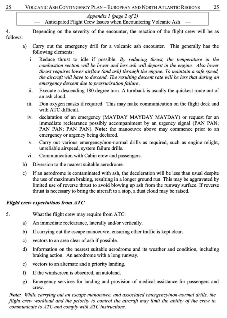
Article from March 2023:
This article is from Rick Gardner of CST Flight Services. We asked if he could talk to us about Private flights to the US – not the standard stuff, but some of the real tips and gotchas that international pilots might want to know about.
Private flights to the US… you probably know the basics already: maybe get a TSA Waiver, file your APIS, contact CBP to get your Permission to Land, and if you’re coming from the south make sure you land at one of the Designated Airports (or else get a Border Overflight Exemption).
But after many years of working with US Customs and Border Protection (CBP) to collaborate on General Aviation issues – here’s a bit of a deeper dive into some of the most common topics and gotchas that private aircraft operators to the US should be aware of…
Arriving from the South
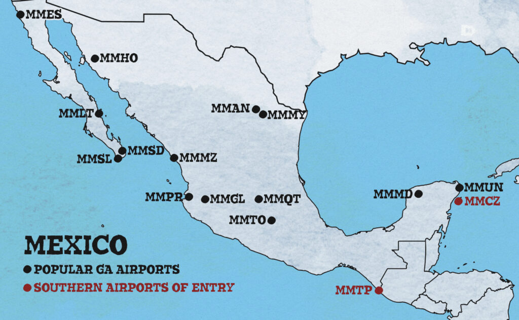
CBP differentiates between aircraft arriving from places “south” of the US versus other countries. Basically, every country in the Western Hemisphere, with the exception of Canada and Bermuda, is considered “south”!
When arriving from one of these countries “south” of the US we must make our first landing at a CBP “Designated” airport closest to our point of border or coastline crossing – unless we have obtained a Border Overflight Exemption (BOE). (More on BOEs in a moment.)
There is a specific list of 32 “Designated” southern airports of entry in the regulations (actually, there are only 31, because KNEW/New Orleans Lakefront is not longer a Designated airport), and that not all CBP airports in Florida or along the Gulf of Mexico coastline nor the US-Mexico border are “Designated” airports. Again, we must make our first landing at the Designated Airport closest to where we cross the US-Mexico border or the US coastline.
However, there are a few exceptions:
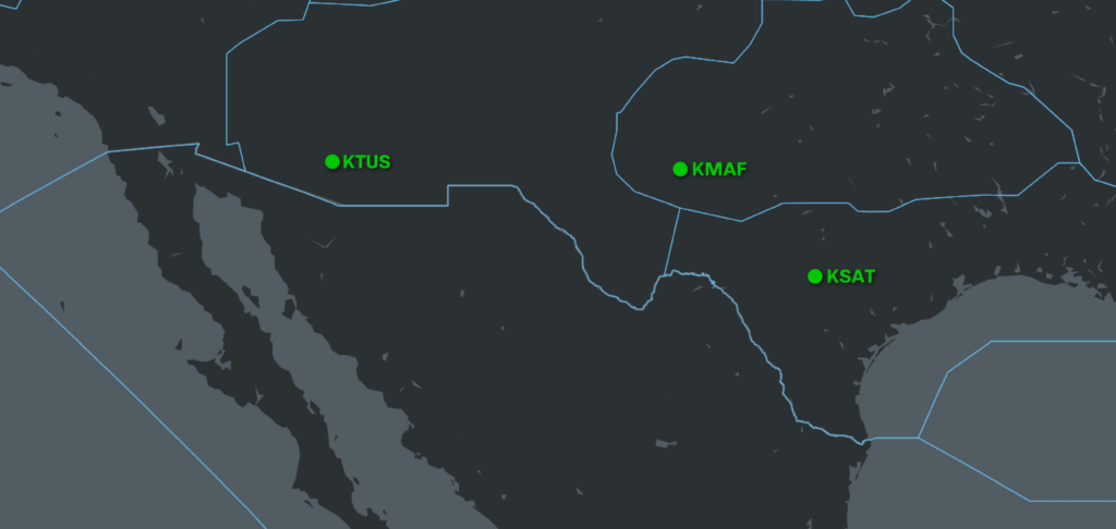
KTUS/Tucson, KSAT/San Antonio, KMAF/Midland
While these airports are Designated Airports, you cannot get to them without overflying another Designated airport. Nonetheless, if you are granted Permission to Land, you may use these airports as your closest airport to the border.
KMTH/Marathon
While not on the list of Designated Airports, KMTH/Marathon is a CBP port and can be used in lieu of a Designated Airport. Be sure to contact CBP at the airport to obtain Permission to Land. (More on Permission to Land in a moment.)
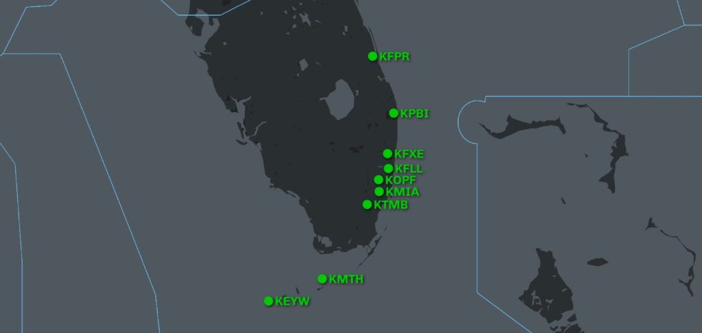
Miami Field Office Airports
So we’re talking about 8 airports here: KEYW/Key West, KTMB/Miami Executive, KMIA/Miami International, KOPF/Opa Locka, KFXE/Fort Lauderdale Executive, KFLL/Fort Lauderdale International, KPBI/Palm Beach, KFPR/Fort Pierce.
The CBP Miami Field Office (MFO) has established that “Flights which are required to land at a nearest designated airport to the border or coastline crossing point may proceed directly to any of the eight designated airports… without an overflight exemption, even if the airport of intended landing is not the one closest to the US coastline crossing point.”
So, if you were returning to the US from Cancun, Mexico, you could overfly Key West and continue up the east Florida coastline all the way to Fort Pierce and you would be in compliance. What you cannot do when returning from The Bahamas is to overfly any of these MFO airports and land in KTPA/Tampa even though Tampa is one of the 32 Designated airports!
Border Overflight Exemptions (BOE)
One way to avoid having to deal with Designated Airports is to obtain a BOE from CBP.
How it works
One of the great things that CBP Headquarters has accomplished is to get rid of the old Forms 442 and 442A and to centralize the BOE approval process. In addition, they have eliminated the previous requirements of having to list all aircraft, foreign ports, crew and passengers that would be authorized under the BOE. Today, all you have to do is identify the operator to whom the BOE will be issued and any aircraft, crew, passengers and foreign ports are all systematically vetted through APIS when the manifest is transmitted.
Per CBP regulations, BOE’s can take up to 30 days to process, so don’t waste time. For more information regarding the application process, contact GAsupport@cbp.dhs.gov.
Gotchas
A BOE holder has to ensure that the Operator specified in the APIS manifest MUST be the Operator to whom the BOE was issued. In addition, to legally use a BOE, the flight must be under IFR, fly above 12,500 feet and not make any intermediate stops.
A BOE is obtained by demonstrating a history of compliance. If you are subject to an enforcement action, the pilot can lose their BOE privileges for 6 months and repeated violations can result in the Operator losing their BOE privilege also.
Advanced Passenger Information System (APIS)
Since Nov 2008, operators of private flights have been required to file a DEPARTURE APIS manifest using the Electronic Advanced Passenger Information System (eAPIS) portal when departing the US for a foreign country, and an ARRIVAL APIS manifest when returning to the US from a foreign country.
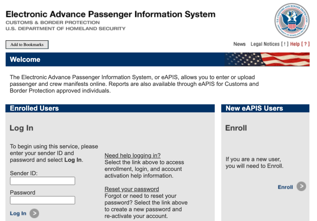
How it works
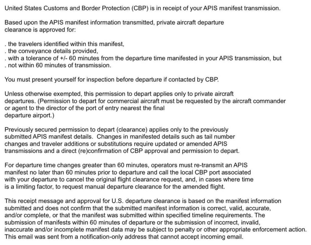
DEPARTURE and ARRIVAL APIS manifests must be filed and authorization from the Department of Homeland Security (DHS) must be received no later than 1 hour prior to departure from the US or foreign country. This DHS authorization comes in the form of a receipt email which contains a summary of the date, time, departure and arrival airports.
As there is no limitation on how early an APIS manifest may be submitted, I recommend that you submit it as soon as possible once your itinerary and crew/passenger information is established. CBP always advises, “Transmitting for next week is fine if your plans have firmed up but next Christmas is too far away.” Leaving things to the last minute just invites Murphy’s law.
You should never be asked to provide Personally Identifiable Information (PII) such as DOB, passport number, SSN, etc. via FAX or email. If you do get such a request, ask for the supervisor, contact CBP headquarters or contact us at +1 786 206 6147.
Gotchas
Double check that the information in the DHS receipt email is accurate! Failing to get the receipt email from DHS means you have not received authorization to depart so you definitely should not depart. Sometimes failing to receive a DHS receipt email may be due to issues with the CBP systems or typos in your email address. Check your SPAM folder to make sure that the email was not sent there. If you share the eAPIS account you are using with someone else, check to see if they changed the email address and ask them to forward the authorization to you. One last resort is to contact CBP at the port and ask if they can determine if the authorization was issued, write down the officer’s name or initials (they might only be willing to give you their badge number) in the event that there is ever a question about whether you received authorization.
The rules also require that if you add/remove/substitute crew and/or passengers or if you make a change to the travel calendar date in either a DEPARTURE or ARRIVAL manifest then you must resubmit a new manifest to CBP. Any authorizations related to the originally submitted manifest are no longer valid and you must wait for a new authorization from DHS. Changes to departure time, arrival time or arrival location may be made by phone.
Another gotcha is failing to make sure that the passenger names on the filed APIS exactly match the names on the passports.
Arriving in the US
In addition to submitting an ARRIVAL APIS manifest and getting the receipt email from DHS, the regulations specifically require us to also contact CBP at the arrival airport and obtain Permission to Land (sometimes referred to as, “Landing Rights”).
Recent changes to how it works!
Historically, different CBP ports have implemented varied procedures for requesting and granting Permission to Land, however that is now becoming more standardized through the efforts of CBP headquarters.
One significant change is that CBP will no longer grant Permission to Land unless you have successfully submitted your APIS ARRIVAL manifest first. When you are granted Permission to Land by CBP at the arrival port, you should receive an email from CBP (in addition to the one sent by DHS) confirming that Permission to Land has been granted and any specific instructions that CBP may have. If you are denied Permission to Land, you will also receive an email from the port confirming that Permission to Land was denied.
Failing to receive the email confirming Permission to Land is an indication that either the port has not yet adopted the new procedure or that Permission to Land was not properly issued by the CBP officer who responded to your request and a follow up request would be advisable. Be prepared to prove who gave you permission to land – the receipt email from DHS alone does not grant you Permission to Land.
Check those attachments!
The email granting Permission to Land will have several attachments. The first attachment is called “CBP Private Aircraft Arrival Information” which contains an overview of what the operator of a private aircraft is expected to do in order to comply with CBP regulations.
In addition, you may also find attached a “General Aviation Airport Fact Sheet” which contains detailed information on what you need to know about the CBP requirements for the specific airport you are landing at. Not only do these two documents clarify what is expected of you, they serve as proof to a CBP officer that you have followed procedures correctly.
Lastly, there is a third document called “Tip of the month” which is a review of important topics that pilots should be aware of and this document is updated monthly. Of the 392 airports where CBP is present, approximately 250 have published Airport Fact Sheets.
Changes to your schedule
The Permission to Land email messages grant permission based on what you have transmitted in APIS and also include port-specific time tolerances; a +/- time allowance based on port operations. If you need to ARRIVE in the US at a time significantly different from that submitted in your ARRIVAL manifest, you need to contact CBP to re-secure Permission to Land for your new arrival time. Many aircraft land at Designated Airports and CBP must ensure that they have the space and manpower to receive and process inbound aircraft.
When you arrive
When arriving in the US, CBP procedures may vary slightly, depending on where you land.
CBP at many airports expect you to keep the door closed until authorized to open it by the CBP Officer. At KTEB/Teterboro, for example, if you deplane before authorized you will be subject to a hefty fine. CBP officers at some airports may not come out to meet the aircraft and may wait inside the building until the crew/PAX come inside. Other airports may have signs with instructions – follow them.
In all cases, especially where health and safety concerns present or exist, CBP always emphasizes to exercise reasonable and responsible judgement. If your aircraft Auxiliary Power Unit (APU) exhaust is 8 feet or higher above the ground, you do not have to power it down. However, CBP can require you to shut down the APU, though, in cases of enforcement actions.
Departing the US
You do not need to depart the US from an airport where CBP is present – you can depart from any airport in the US.
How it works
In your APIS DEPARTURE manifest you should enter the airport code of the nearest CBP airport to the departure site and then in the “Actual Departure Location Description” field, describe the actual place from which the aircraft will depart. This is an optional field which should be used only when the location of actual departure differs from the airport listed in the “CBP Airport” field. The “City” field should be the actual city from which the aircraft is departing.
When you submit an APIS DEPARTURE manifest to CBP and you receive DHS authorization to depart, the authorization is based on the information that you have submitted, including the departure time.
Spot checks!
On occasion, CBP conducts random departure inspections on aircraft departing from the US (it has happened to me) and officers will be dispatched to your departure airport location. If they arrive and you have departed before the time you specified or if you are nowhere to be found and then depart after the time specified, you could be subject to enforcement action. Always update departure times with CBP!
Canceling or postponing a flight
You are required to advise CBP if you are going to cancel your flight or postpone it to another date (which will require that you file a new manifest). This is important because CBP plans their workload and staffing based on manifests that they can see in the system.
How it works
Under CBP’s updated procedures, when you cancel an APIS manifest, you will also receive an email confirming that your APIS manifest has been canceled. If you transmitted multiple APIS manifests for the same date, the CBP port may cancel the unnecessary manifests which can trigger an email saying that the “APIS was cancelled”. Remember that each submitted APIS manifest has a unique eAPIS number as does the DHS receipt email and CBP cancellation email so you can match them. If you are ever in doubt, you should contact the port to confirm.
Transporting currency
Another important point is that you must always report if you are taking into, or out of, a country more than $10,000 USD. It is not illegal to transport more than that amount, but failing to report it is illegal.
The nitty gritty
When you transport, attempt to transport, or cause to be transported (including by mail or other means) currency or other “monetary instruments” in an aggregate amount exceeding $10,000 or its foreign equivalent) at one time from the US to any foreign country, or into the US from any foreign country, you must file a report with US Customs and Border Protection. This report is called the Report of International Transportation of Currency or Monetary Instruments, FinCEN Form 105. This form can be obtained at all U.S. ports of entry and departure or on the Web at FinCEN Form 105 (Rev. 7-2003).
Alternatively, the report can be filed electronically, an eCMIR, at this website. Travelers will be able to enter information into an eCMIR up to three days prior to travel, creating a provisional document on the CBP.gov website. Foreign countries will also have their own documents and procedures. Failing to report can result in seizure of the monetary instruments, fines, or worse.
CBP officer says it’s OK
One topic that comes up repeatedly is that a CBP officer “Buddy” says its OK to land without a BOE or approves some other deviation from the rules.
Don’t do it!
CBP headquarters has made it very clear that no CBP officer has the authority to override US law. Doing so could get both you and the officer into trouble. Don’t succumb to the temptation of listening to what you want to hear versus what you need to know! Enforcement actions can cost you money, ruin your reputation with CBP and cause you to lose BOE privileges.
Visa Waiver / ESTA
Part of the joy of having a private aircraft is to share the experience with family and friends…
Visa Waiver gotcha
If any of those are citizens of Visa Waiver countries and they do not have a US Visa, then they cannot fly into the US on a private aircraft unless you are a signatory carrier or under some very isolated and specific circumstances. Contact CBP before you attempt to do so to avoid unpleasant surprises. If there is any chance that you may transport citizens from Visa Waiver countries, submit your request to become a signatory carrier now, while there is time.
PIC Responsibility
Yep, you know this already. As PIC you are ultimately responsible for compliance with all the regs. In the case of CBP, the PIC is responsible for ensuring that valid passports are brought aboard the aircraft that match the APIS manifest information submitted to CBP and that authorizations to depart are properly received.
Getting it wrong
If you ever do face an enforcement action, best to just be honest. CBP is not out to get us, what they want is compliance and have repeatedly demonstrated a willingness to work with General Aviation to achieve it. Work with them and they will work with you. This is not a guarantee that CBP will not take enforcement action, those determinations are made on a case-by-case basis and much depends on the nature and circumstances of the violation as well as the way you handle it. Violations are usually the result of either an oversight or wilful intent – you don’t want to give CBP the reason to believe that you are part of the latter if that isn’t the case!
Illegal Charters
Unless you have a burning desire to find out more about both the US and foreign legal systems, do not misrepresent yourself as a private aircraft flight when in fact you are operating as a commercial aircraft operator!
Understanding the Regs
CBP defines a “commercial aircraft” as “any aircraft transporting passengers and/or cargo for some payment or other consideration, including money or services rendered” as per 19 CFR 122.1 (d). Note that CBP’s definition of private and commercial are different from those used by the FAA.
Some US pilots believe that US regs apply to them when flying internationally, but 14 CFR 91.703 (a) (2) clearly states that they must abide by the laws of the foreign countries where they operate. Many of these countries also have much more basic definitions of commercial and non-commercial operations.
Bottom line – don’t try to walk a fine line with Part 91 definitions as this could land you in hot water with the CBP as well as with the civil aviation authorities of foreign countries.
Puerto Rico and US Virgin Islands
Time for some bulletpoints, all nicely colour-coded…
- Flights between the continental US and Puerto Rico are considered domestic flights as long as the flight is conducted under IFR, the flight is above 12,500 feet and there are no intermediate stops.
- Flights from Puerto Rico to the US require a US Department of Agriculture (USDA) inspection in Puerto Rico prior to departure.
- Flights from the US and Puerto Rico to the US Virgin Islands are considered domestic flights BUT flights from the US Virgin Islands to the US and Puerto Rico are treated as international flights.
- When departing the US Virgin Islands to the US, always go through the pre-clearance process with CBP in the US Virgin Islands before departing. APIS must be transmitted as an ARRIVAL into the US.
Other Gotchas!
Check those pesky passports again
The PIC should verify that the doc that were used for the submission of the APIS manifest are on board the aircraft. This can maybe be a bit awkward, but it is the PIC’s reputation with CBP and a possible enforcement action and loss of BOE privileges that are at stake. Some of the more common issues that arise are:
- Missing passport, the passenger forgot to bring it
- Bringing a different passport form the one use in the APIS manifest, passenger has 2 passports
- Bringing spouse’s or child’s passport by mistake
- Bringing a passport card instead of a passport, passport cards are not valid for use on an aircraft
Remember, an APIS manifest needs to contain verified and accurate information, the PIC must validate that what they have submitted is correct. CBP has told us repeatedly that transmitting bad data is always grounds for enforcement action.
Guns
Another common gotcha is trying to reenter the US with firearms after a hunting trip. You should present firearms to CBP along with CBP Form 4457 before leaving the US.
Diamonds are a girl’s CBP officer’s best friend
Same as above! Any high value item such as camera/video equipment, jewelery, etc need to be declared to CBP before leaving the US.
Q&A
1. General Aviation Airport Fact Sheets. These sound interesting! Are these fact sheets located anywhere on the CBP website? Or elsewhere on the internet?
CST Flight Services has all the CBP Fact Sheets. If you email us we can send you the latest for the airport you need: customersvc@cstflightservices.com. We plan to have a self-serve web page up and running shortly, where you can access the files 24/7.
2. Can operators start the BOE process before 45 days? Just to ensure they have this before it expires and they have to stop somewhere that’s inconvenient?
You can try but it will almost certainly be rejected. CBP does not want any renewal requests that are more than 30-45 days out with 45 days being the upper limt.
3. When arriving in the US, do all your FPL alternates also need to be airports with CBP on site? What would happen if you had to divert somewhere else?
Safety of flight always comes first, however you can expect some tough questions like “why didn’t you select a planned alternate where CBP is present?”
If the diversion is a true emergency (smoke in the cockpit, engine failure, medical emergency), I think CBP would work with you. An emergency due poor flight planning such pushing the aircraft’s range or something similar may not go so well.
In the 20 years of working with CBP headquarters the mantra has been “reasonable and responsible.” If you can demonstrate that your actions were reasonable and responsible then you should be OK, if you cannot, then it probably will not be OK!
4. The same question, but for a flight arriving from the south, without a BOE. Can they only list Designated Airports as their FPL alternates?
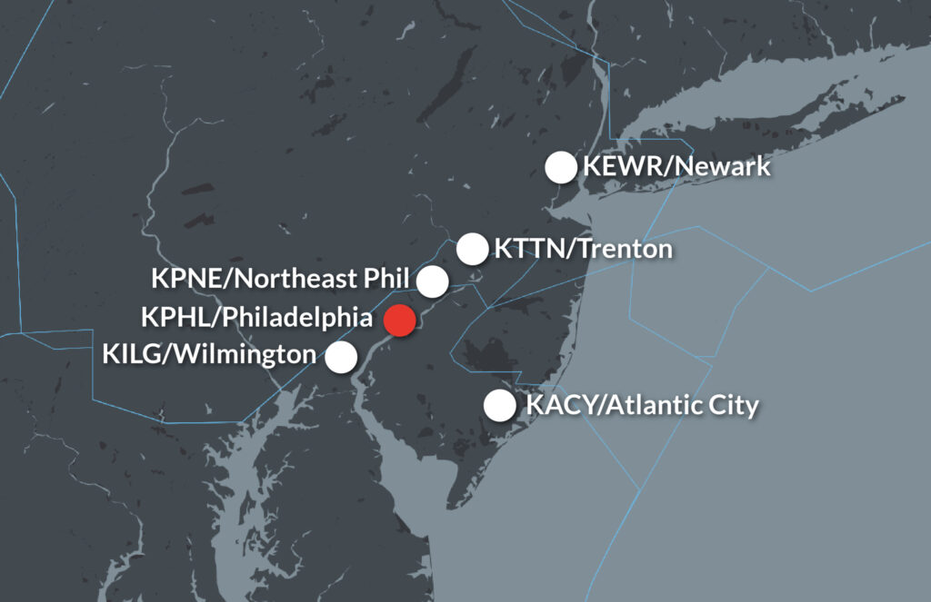
Same answer as above. The reality is that with the exception of KILM/Wilmington, the Designated Airprots are along the US-Mexico border, Gulf of Mexico shoreline and South Florida. There are a plethora of possible alternates that are Designated Airports, so you may have a hard time explaining why you didn’t choose one of those.
Anything we missed?
If you have questions about any of the above, or if you think there’s something we missed, let us know!
About the author:
Rick Gardner of CST Flight Services, a company which provides a wide range of international trip support services for both owner-pilots and professional pilots. Rick is also the representative for the Aircraft Owners and Pilots Association (AOPA) in Mexico, Central America, The Bahamas and the Caribbean as well as a Bahamas Flying Ambassador, member of The Bahamas Civil Aviation Council and has participated on aviation committees of other foreign countries.
www.cstflightservices.com / customersvc@cstflightservices.com / +1 786 206 6147
Are you someone with knowledge to share?
Know something worth knowing about something? Want to write about it? Let OPSGROUP know! Maybe we can work together and write an article on it.


 …although the last one is still recommended by the FAA.

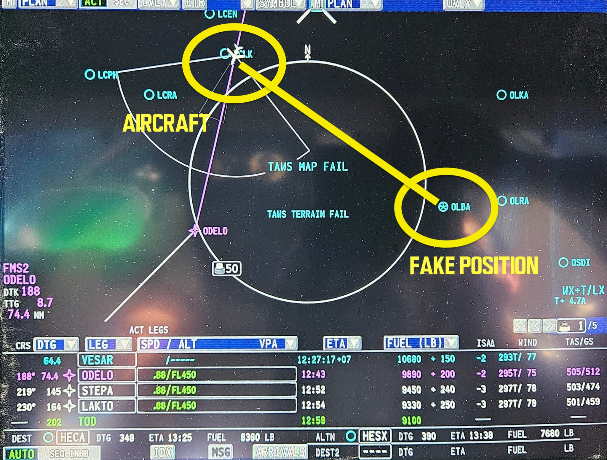


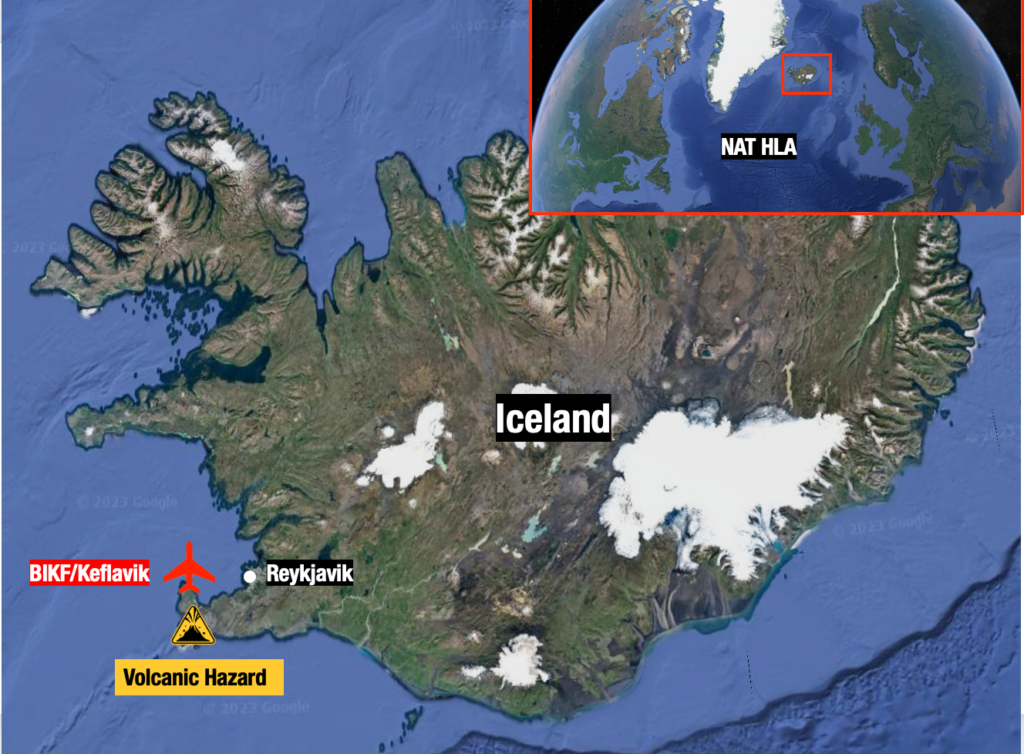
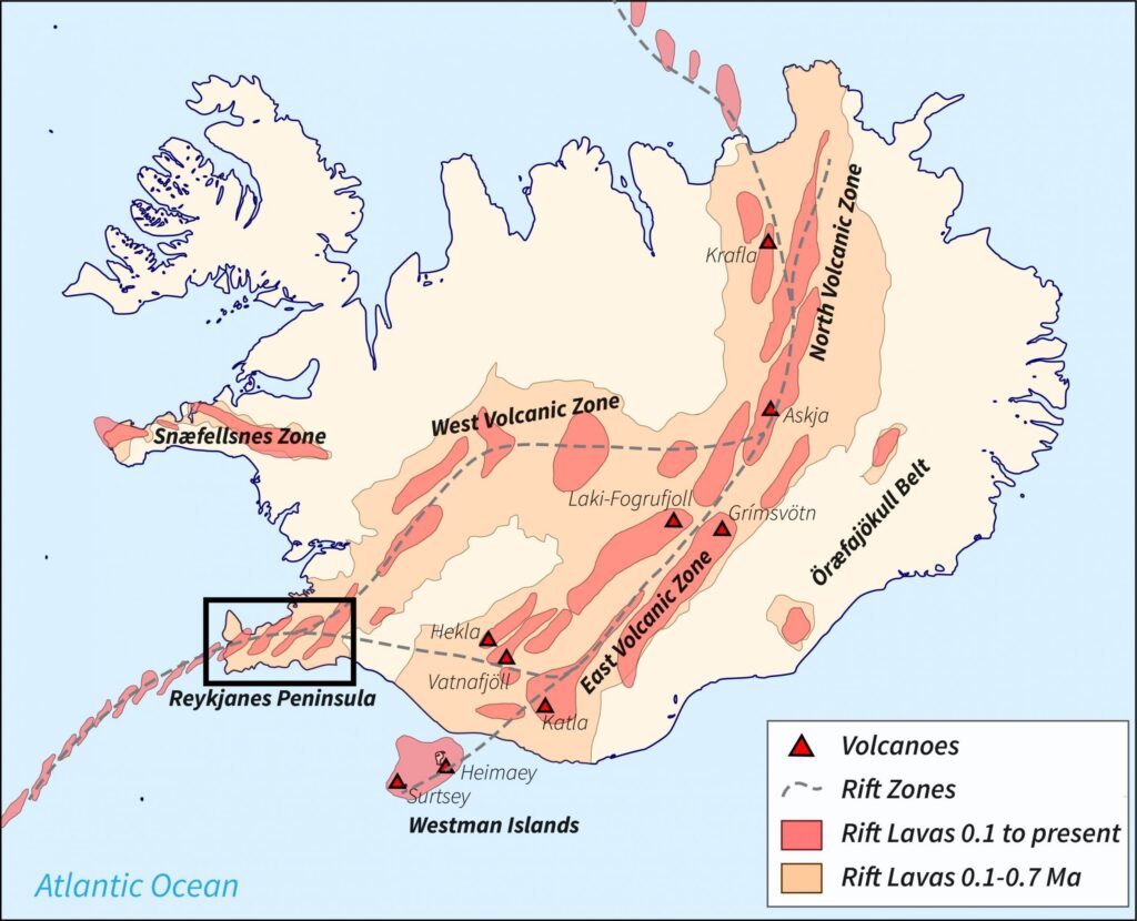
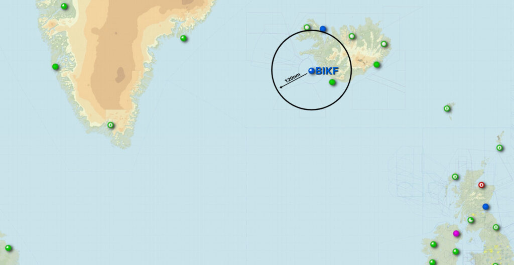


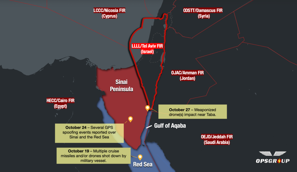
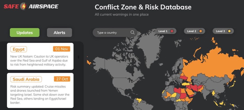
 All traffic crossing the NAT or operating over Western Europe right now should be keeping a close eye on this one.


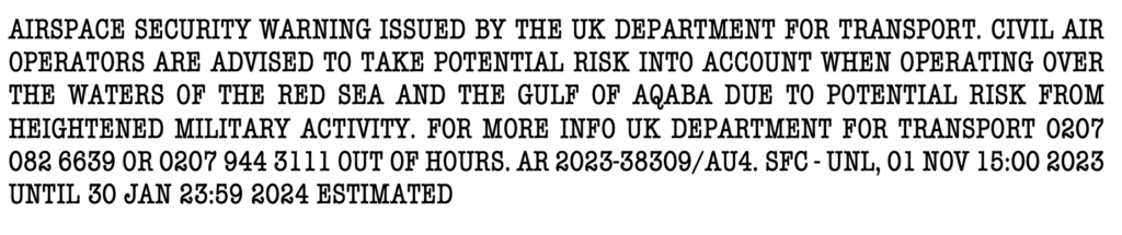 Airspace warnings aren’t new for the
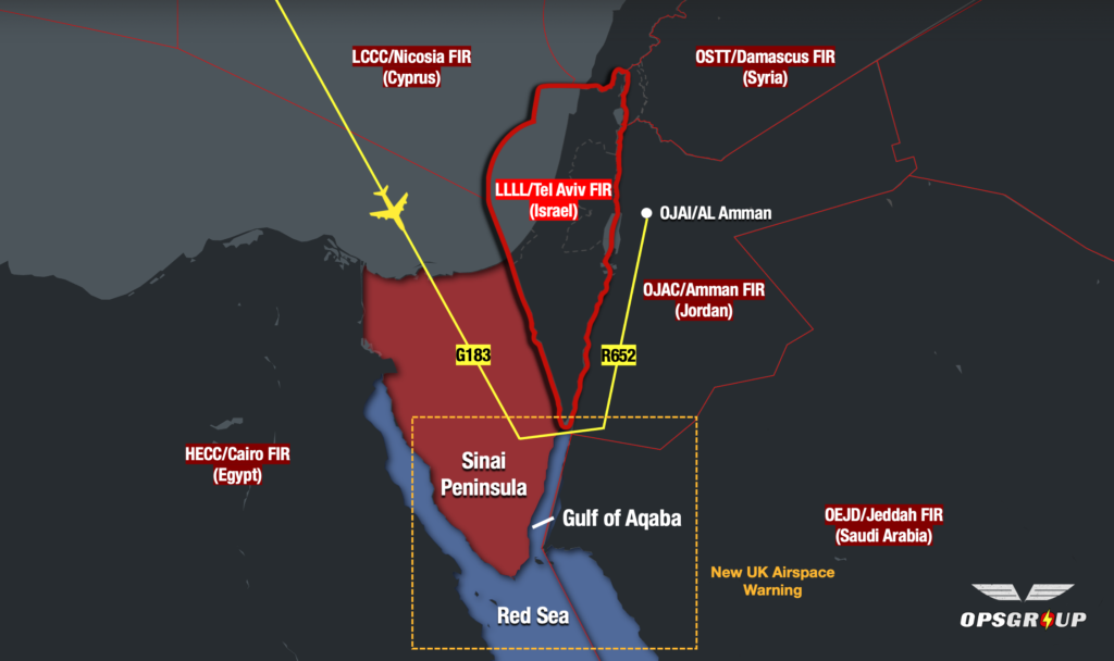


