Circling: Why Is It So Dangerous?

April 2026 Update:

It’s been three years since we originally published this article on the inherent dangers of circling approaches. New data from the Aviation Safety Information Analysis and Sharing program (ASIAS) – a big US aviation data-sharing system run by the FAA and industry partners – shows that we’re still getting these approaches dangerously wrong.

The report links circling to loss of control and CFIT accidents among Part 91 and 135 operators, with 17 fatalities between 2008 and 2023.

Here’s what they found, and why it still matters.

The ASIAS report.

The study used real-world accident data along with FOQA reports to analyse circling-to-land accidents and incidents, not just theory. The bottom line is that circling approaches are still catching crew out. They keep showing up in loss-of-control, CFIT, and unstable approach events. And the pattern is consistent.

What’s actually going wrong.

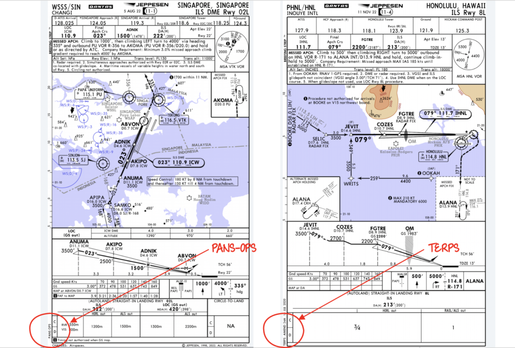
The big one – leaving circling area. Crews are ending up outside of the protected areas by either flying too wide, too far or too fast. Once you’re outside, there’s no more obstacle clearance. It’s safety critical that you know your approach category, and the circling area that applies i.e. PANS OPS or TERPS. If you’re not familiar with these terms, we cover them in detail in the original article below.

The unstable approach ‘chain’ rarely starts with just one mistake. A typical sequence might include being high or fast, leading to a rushed visual segment and unstable approach. From there, continuation bias can take the controls leading to attempt to salvage a landing, rather than go-around.

Ever heard of ‘the six P’s?’ Chances are we’ve all grappled with it at one stage or another in our careers: ‘Prior Preparation Prevents P*** Poor Performance.’ It’s crude way of saying we fly better when we are prepared. The ASIAS report identifies that poor set up before circling is leading to accidents. This includes inadequate briefing, no clear plan for the manoeuvre and no defined escape/go-around point. In other words, crew are ‘figuring it out’ while already low.

Our eyes play tricks on us. Circling at night or in reduced visibility, sloping terrain, black hole effect and even workload at low levels makes it easy for us to misjudge distance, height and turn radius.

Worryingly, this isn’t just about accidents. The data also shows numerous unstable circling events that didn’t end a crash. So the risk is bigger than accident stats suggest.

Practical Takeaways

Circling isn’t routine, treat it as high risk. If there’s a straight-in option, take it. If you do need to circle, it’s essential to plan it properly before you start, stay within the circling area and if’s not working, go around. At night or in marginal VMC the risk increases dramatically.

Original Article:

Here’s a startling statistic – according to the Flight Safety Foundation, straight-in approaches are twenty-five times safer than circling ones. Twenty-five times!

It’s no wonder then that the NTSB are concerned. In fact, they identified that there were ten major accidents involving Part 91 and 135 operators between 2008 and 2023 while flying a circling approach.

We smell risk, and so does the NTSB. Which is why in March 2023 they issued a new safety alert. Asides from the obvious risks of operating a high-performance aircraft at low speed and altitude in poor visibility, there appears to be another threat too – key differences between ICAO PANS-OPS and US TERPS.

Let’s take a closer look…

The NTSB Alert

The NTSB’s key takeaway seems to be this: you don’t need to circle. You can also request a runway aligned approach, or if that isn’t practical, a diversion.

Of course, if a straight-in approach isn’t available, a diversion for a commercial operator would likely be a tough sell when there is a legal and procedural approach to the runway in front you.

But if you do, it implores you to understand and thoroughly brief the risks.

The reality is that circling approaches are far riskier. They involve manoeuvring an aircraft low to ground, and low in energy in marginal conditions. This opens the door to two major dangers – loss of control, and collision with the hard stuff.

They’re also not particularly conducive to a stabilised approach, which typically involves being runway aligned by 500’ off the deck in VMC conditions, or higher in the soup.

Then there is the elephant in the room – our own limitations. As pilots we are responsible for setting our own personal limits. More often than not, these rest within the ones defined by law. Familiarity, experience and conditions all come into play when assessing our appetite for risk.

In other words, just because a procedure is legal doesn’t mean we should fly it.

The NTSB also identifies that training (or lack of) is an issue. When was the last time you circled in the simulator? To fly circling approaches safely, we need to be practicing them in our re-currents regularly and in different conditions.

This is where the NTSB alert ends, but there may also be more to it than that – the way circling procedures are designed may also be partially to blame…

The PANS-OPS versus TERPS Conundrum

It will likely be no surprise that instrument approach and departure procedures are designed to keep aircraft safely away from terrain and obstacles to internationally accepted standards.

To make this happen, there are two main sets of procedures:

  1. ICAO Procedures for Air Navigation Services (PANS-OPS) used throughout Europe and in many other parts of the world. You can these in ICAO Doc 8168.
  2. United States Standard for Terminal Instrument Procedures (TERPS) used throughout the US, Canada and in some other countries such as Korea and Taiwan. Those details are in FAA Order 8260.3D1.

When we circle, we need to understand how the procedure was designed (PANS-OPS or TERPS) and what the differences are, which can be significant.

The reality is that under TERPS, in some cases aircraft are required to fly slower, with higher angles of bank in more restrictive circling areas despite improvements made back in 2013. And all of this can happen in lower visibility than in PANS-OPS procedures.

Could this be one of the contributing factors to circling accidents in the US and Canada? Possibly.

What are the differences?

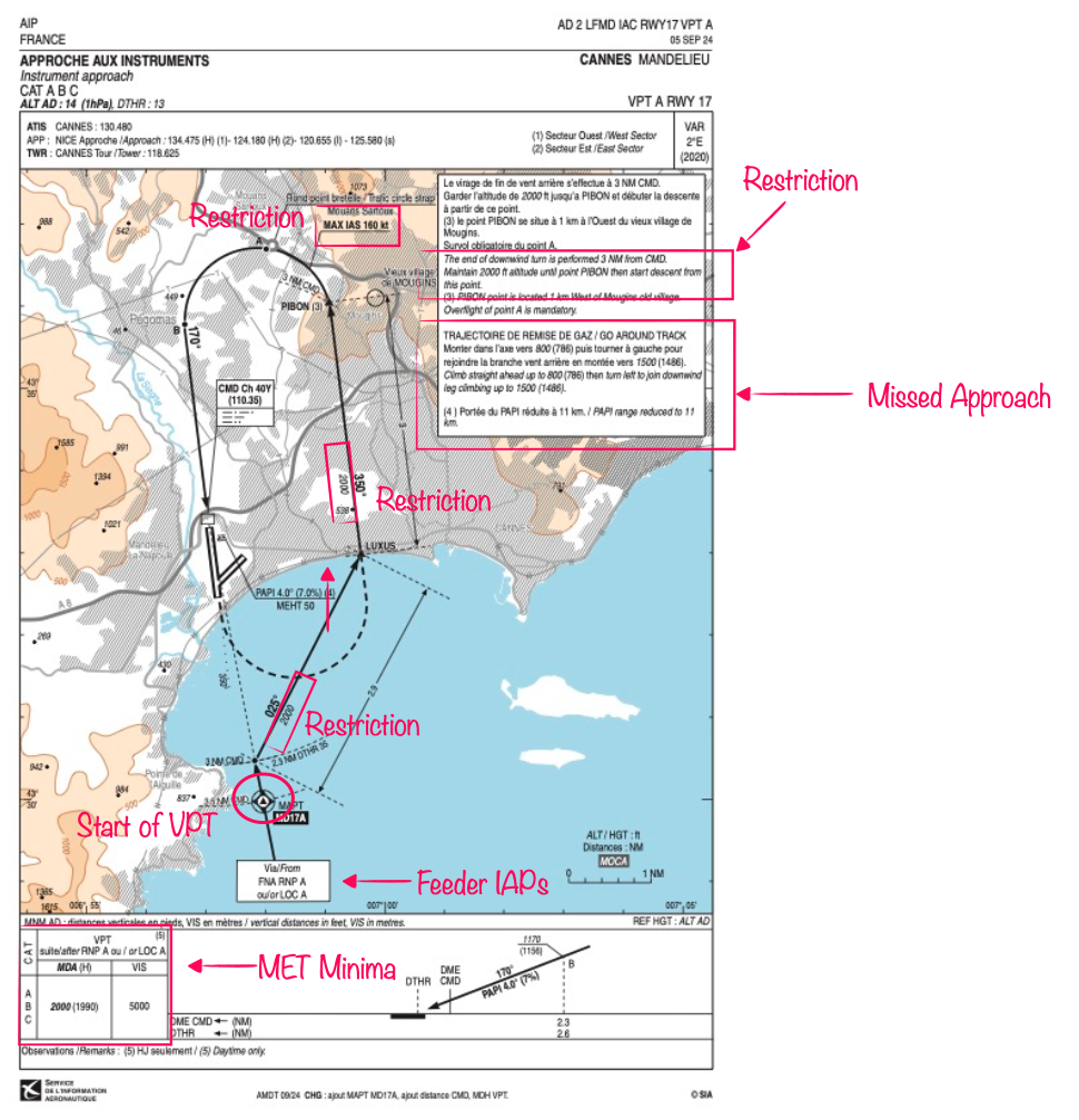
In both systems, a radius is drawn from the centre of the threshold for a particular runway inside of which obstacle clearance has been assessed. It’s known as a circling area, or domain.

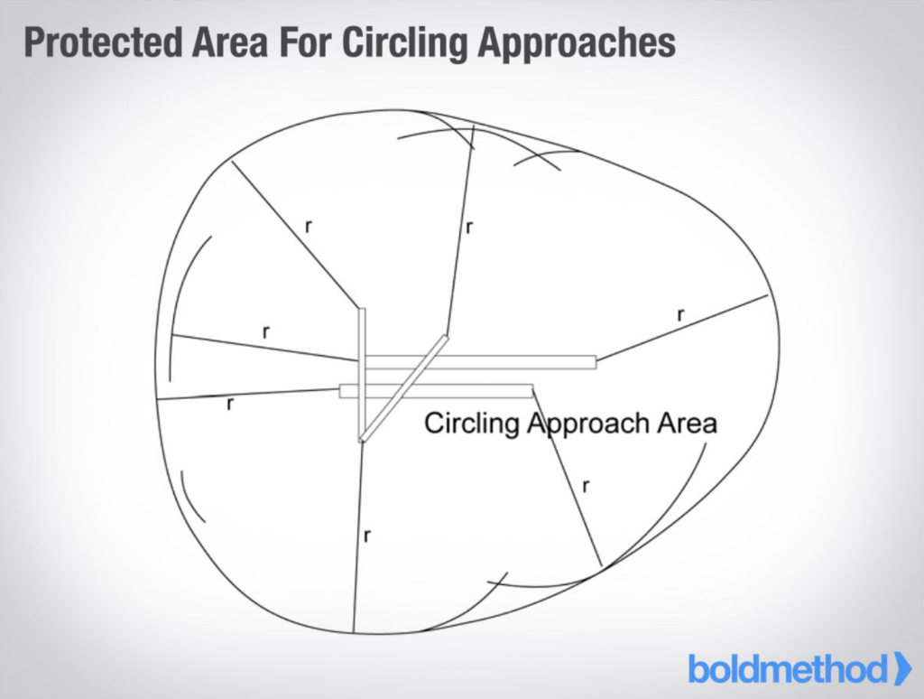
Protected areas are drawn from arcs from the center of each threshold. Courtesy: Boldmethod

The size of this area increases with aircraft category – essentially if you’re heavier, you need to fly faster which means your turn radius increases, and you need more room to circle. This is taken into account using TAS and bank angle when the procedure is designed – along with a healthy dose of mathematical wizardry.

But herein lies an essential difference.

PANS-OPS bases TAS on altitude and circling IAS. TERPS on the other hand bases this on altitude and IAS at threshold. The result is a much smaller circling area, and in some cases higher bank angles.

The maths behind circling approaches is complicated, but the key difference between PANS-OPS and TERPS is IAS.

Take a Category C aircraft for instance (threshold speed 121 – 141 kts). Under PANS-OPS the circling area for an approach would extend to 4.2nm, while under TERPS (with an MDA of less than 1000’) the same area would extend only as far as 2.7 nm. For lower category aircraft, this also increases minimum bank angle beyond 20 degrees. Things can start to get tight.

In a nutshell, because ICAO uses higher IAS for its TAS calculations, and assumes a lesser angle of bank, its circling areas are far roomier.

International operators in particular may be at risk of straying outside of the circling area if they are not familiar with the more restrictive TERPS procedures. To make matters worse, some countries may not be 100% one way or the other. A straight-in approach may be designed to PANS OPS, while the circling approach is designed to keep you within a TERPS assessed area – Mexico and Chile being examples.

And in some cases, all of this can happen down to a minimum visibility of just 1.5 miles (2.4km) under TERPS, versus 2.3 miles (3.7km) under PANS-OPS.

How do I know what kind of procedure I’m flying?

Get your magnifying glass out. It will be written in the margin of your chart. If you’re using Jeppesen, have a look at the bottom left-hand side, written vertically. It’s far from obvious.

Once you’ve established what type of approach you’ll be flying, you’ll need to think about speed, your circling area, and whether the visibility is appropriate. We’ve put together a little cheat sheet that may help…

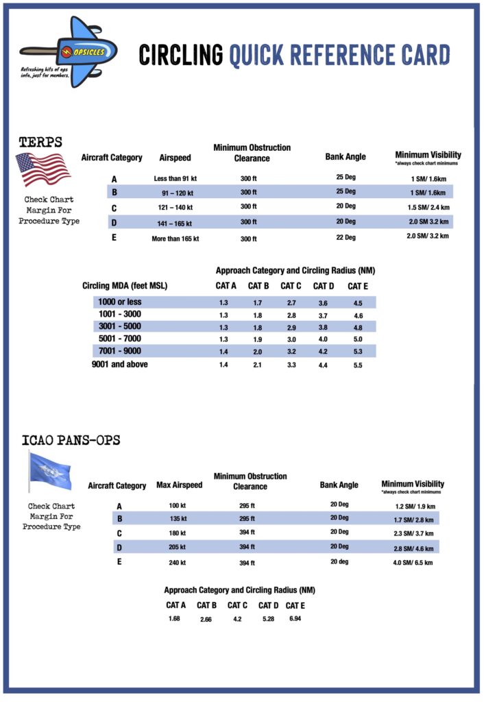
OPSGROUP members: Click to download PDF.

The Stats Don’t Lie

We’re getting circling approaches tragically wrong. What the industry is currently teaching pilots doesn’t seem to be cutting the mustard – and the Flight Safety Foundation agrees. Pilots need to be more aware of the design criteria used for circling approaches, and the limitations that places on their aircraft. This also needs to be made far clearer on approach charts if we’re to reduce risk on these challenging manoeuvres.


Middle East Airspace – Current Operational Picture

13 April Update:

The central Middle East corridor is still largely shut, but it’s no longer a simple “open vs closed” picture.

Iran and Kuwait remain the only FIRs that are clearly closed. Iran is closed to normal commercial traffic, with only limited categories of flights operating under prior approval. Kuwait is also issuing new Notams each day closing its airspace, so it’s not usable for planning.

Across the rest of the Gulf, several FIRs are technically open, but only in a very controlled way:

Qatar: Closed to overflights. Only approved arrivals and departures are allowed via specific entry and exit points, and everything is tightly managed. In practice, this means Qatar is not functioning as a normal hub – only selected traffic is getting in and out, and routings are fixed.

UAE: Partially open but running a strict corridor system. Traffic is being funnelled through specific routes depending on the airport, and overflights are limited to a single westbound flow. Airlines are using it, but in a very controlled way – this isn’t free-flowing airspace, and approvals and routing constraints are part of every flight.

Bahrain: Open again, but everything requires prior approval. It has also seen short-notice full closures over the past couple of weeks, so treat it as usable only with coordination, not something you can depend on tactically.

Iraq: Technically open again, with no current FIR-wide closure Notam in force, but not being used in practice. With Kuwait airspace closed and the wider Gulf system disrupted, there is no viable north-south transit through Iraq at the moment.

Elsewhere, airspace is open but working under pressure:

Saudi Arabia: Open and now a key part of the southern bypass. Traffic is being funnelled onto a reduced set of routes due to military activity. Airlines are using it heavily, but it’s not running at normal capacity – expect flow restrictions and plan extra fuel.

Oman: Also fully open and has become a major staging point and transit FIR for traffic avoiding the Gulf. It’s one of the more stable parts of the region right now, but GNSS interference has been reported, and routing is still influenced by how UAE and Saudi corridors are set up.

Jordan: Open and operating normally. In practice, it’s not a major transit route for Europe-Asia traffic. Most operators continue to route via Egypt and Saudi Arabia, as they did before the conflict.

Israel: Also open, but not in a normal sense. Access is tightly controlled, most flights require prior approval, and traffic levels are still very limited. Some local and approved flights are operating, but most international carriers are still staying away, and there is still the risk of short-notice disruption.

Armenia/Azerbaijan/Afghanistan: Armenia and Azerbaijan have become key parts of the northern bypass, with steady overflight demand. The main issue here is that you then have Afghanistan airspace to deal with – the OAKX/Kabul FIR is open and seeing heavy overflight demand as part of the north routing, but remember it’s Class G with no ATC service available, so you have to follow the published contingency routes.

So for Europe-Asia traffic or Gulf positioning, there are still only two real options – north via the Caucasus then Afghanistan, or south via Egypt then Saudi then Oman:

Recent developments

April 12-13 – Pakistan talks fail, ceasefire uncertain

High-level US-Iran talks in Islamabad ended without agreement. The talks were aimed at stabilising a temporary ceasefire announced on April 8, but both sides walked away without a deal. The ceasefire remains in place for now.

April 12 – Threat of Hormuz blockade

Following the collapse of talks, the US has announced plans for a naval blockade of Iranian ports and the Strait of Hormuz. Iran has warned this would be treated as an act of war. This significantly increases the risk of further escalation and sudden airspace closures across the Gulf.

April 9 – EASA CZIB update

EASA has updated its CZIB on Middle East airspace, now valid to April 24. The same advice stands to avoid airspace of Bahrain, Iran, Iraq, Israel, Jordan, Kuwait, Lebanon, Qatar, UAE, Oman and Saudi Arabia.

There’s one narrow exception: in Oman and Saudi, you can operate south of a line from OBSOT-DANOM-KEDON-VELOD, at FL320 or above only, and only with a current risk assessment.

April 8 – Temporary ceasefire announced

The US and Iran agreed to a two-week ceasefire in an effort to halt escalation and reopen the Strait of Hormuz. This has led to some limited reopening of airspace across the region, but has not restored normal operations.

April – Regional strikes continue

Despite ceasefire efforts, military activity continues across the region, including ongoing Israeli strikes in Lebanon. This shows the conflict is not contained to Iran alone, and the wider regional risk picture remains elevated.

April – Operators remain cautious

Even where airspace has reopened, most international operators are still avoiding the region or using only tightly controlled routings. Short-notice closures, missile and drone activity, and general unpredictability are still driving cautious decision-making.

March 30 – Missile intercepted over Turkey

Another Iranian ballistic missile was intercepted over southern Turkey, with debris reported near the Syrian border. Turkish airspace remains open with no operational impact, but the incident again shows how far west some of the missile activity is extending.

March 24-30 – UAE short-notice closures continue

The UAE has continued to briefly close its airspace during new missile and drone threats, reopening shortly afterwards. This reinforces the risk of sudden disruption even when the FIR is technically open.

March 24 – OKKK/Kuwait airport fuel tank hit

A drone strike hit a fuel storage tank at OKKK/Kuwait, causing a fire. No casualties reported, but this is another direct strike on airport infrastructure and highlights the ongoing risk to ATC and fuel systems.

March 20-23 – No improvement, escalation continues

There have been no airspace re-openings since our last update – the overall picture remains unchanged, with Iran, Iraq, Kuwait and Syria still closed and Gulf FIRs operating under strict restrictions.

Missile and drone activity across the Gulf has continued, with multiple intercepts reported daily in UAE and Saudi airspace.

There are also growing concerns around the Strait of Hormuz, with Iran threatening restrictions or closure – this raises the risk of further sudden airspace changes across the Gulf FIRs.

No new confirmed strikes on airports since March 18, but attacks on energy infrastructure across UAE, Qatar and Saudi highlight the continued risk.

March 17 – UAE airspace closure

The UAE briefly closed its entire airspace overnight on March 16-17 as an “exceptional precautionary measure” during new missile and drone threats.

It lasted about two hours before reopening, but caused fresh disruption to already limited ops into OMDB/Dubai and OMDW/Al Maktoum.

This comes just one day after the drone strike near OMDB, and shows how quickly the situation can change – even FIRs that are technically open can shut with little or no warning.

March 16 – LLBG/Tel Aviv BizAv ban appears to ease

Earlier this week we reported that BizAv flights were not being approved at LLBG/Tel Aviv, based on guidance from the Israeli CAA and multiple Opsgroup member reports. That restriction did not appear in the Notams at the time.

A local handler at QAS Executive Aviation (pvt@qasisrael.co.il) has now advised that BizAv operators can again apply for PPR approval through the airport ops center. The current Notam still reads: AD CLSD TO ALL FLT, EXC PPR FLT FM AD OPS CENTER and runs until March 23 at 1000z.

Slots remain extremely limited and priority is still being given to emergency and state flights, so approvals may be difficult to obtain. Check with your handler before planning any BizAv ops to LLBG.

March 16 – OMDB/Dubai drone strike halts flights

A drone strike hit a fuel storage tank near OMDB/Dubai, causing a large fire and forcing a temporary suspension of operations. At least 65 flights diverted to airports across the region, including OMDW/Al Maktoum, while others held or turned back as emergency services dealt with the blaze.

March 14 – Drones strike OKKK/Kuwait airport radar

Kuwait authorities reported that multiple drones targeted OKKK/Kuwait airport, damaging part of the airport’s radar system. No casualties were reported, but the incident highlights the potential for ATC capability to be degraded if radar infrastructure is damaged.

March 11 – Opsgroup member reports

OMDW/Al Maktoum turn: One member reported a recent turn at OMDW/Al Maktoum with generally smooth operations despite the regional situation. Arriving from the north, the only operational issue was GPS jamming beginning near Riyadh. The airport itself was quiet and well organised. Departure was delayed by about five minutes due to military activity. The permit process was more involved than usual, requiring a risk assessment before approval as part of the current UAE corridor procedures (see this section below for more info).

OERK/Riyadh rescue flight: Another member operating a Part 121 rescue flight reported smooth ops on a routing Germany-Riyadh-Germany. The permit process and UAE GCAA No Objection Certificate were issued without problems. Ground handling at OERK/Riyadh was efficient, with fuel uplift starting immediately on arrival and a two-hour ground time. The western routing via Saudi-Egypt-Greece worked without issues. They also reported that insurance applied a premium for the trip, and the flight required a Safety Risk Analysis including FAA considerations.

March 9-11 – Gulf missile and drone attacks

Iranian missile and drone attacks continued across the Gulf between March 9 and 11. Saudi Arabia, Kuwait and Qatar reported intercepting several missiles and drones, while the UAE activated air defences during alerts that briefly caused arrival holding at OMDB/Dubai. Authorities also reported drones falling near Dubai on March 11, injuring several people, though airport operations continued. No airport strikes or new airspace closures have been reported so far.

March 7 – OMDB/Dubai drone incident

OMDB/Dubai Airport briefly suspended operations on March 7 after a drone struck near Terminal 3, causing minor damage and smoke near the terminal area. Flights were halted while authorities checked the airport and several arrivals aborted or held. Operations resumed later the same day, though delays continued across the airport.

March 7 – OTHH/Doha limited reopening

Qatar has begun a very limited reopening after closing its airspace at the start of the missile and drone attacks. A small number of evacuation and cargo flights are now operating with specific approvals, but this is not a full reopening – regular passenger services remain suspended and capacity remains very limited.

March 6 – Israel

Ops at LLBG/Tel Aviv were briefly disrupted when an El Al repatriation flight had to abort its landing after missile sirens sounded across central Israel during an Iranian attack wave. The aircraft entered a holding pattern before returning for a second approach once the alert was lifted.

March 6 – OOMS/Muscat “scheduled flights only” Notam

Some media reports say Muscat is restricting BizAv flights due to congestion from evacuation traffic. A Notam appears to support this: OOMS airport accepts scheduled flights only, all diversion flights subject to prior approval. However, a local handler at Jetex OOMS has advised that normal BizAv operations are continuing, and operators should not expect any practical impact from this Notam for now. Contact them at: fbo-mct@jetex.com for more info.

March 6 – UAE airports operating limited flights

Airlines have started operating more flights from UAE airports using the restricted corridor system, though capacity remains well below normal levels.

A local handler has advised that to use the current repatriation corridors into UAE airports, you must first obtain a No Objection Certificate (NOC) from the GCAA Foreign Operators Affairs Department (FOA). Operators reportedly submit a short risk assessment to foa@gcaa.gov.ae, after which a NOC is issued. This must then be provided to your handler for the landing permit request. Response times are typically less than 60 mins, and a single NOC can cover multiple flights for the same aircraft during the recovery period. You can find an example of a completed risk assessment here.

March 6 – Oman becoming a staging point

Flightradar24 are reporting that OOMM/Muscat is becoming a staging point for evacuation and repositioning flights. Airline and private aircraft have been using the airport to position for repatriation flights, as it sits just outside the most restricted Gulf airspace while still providing access to the southern bypass route via Saudi Arabia and Egypt.

March 5 – Azerbaijan drone strike

Iranian drones crossed the Iran-Azerbaijan border early on March 5 and one struck the terminal building at UBBN/Nakhchivan airport. Damage appears limited to the terminal area with no confirmed runway impact. This is the first time the current Iran conflict has spilled into the Caucasus, close to the Armenia-Azerbaijan overflight corridor used by traffic avoiding the Middle East airspace closures. No impact has been reported to UBBB/Baku airport or the main overflight flows.

March 4 – Missile interception over Turkey

On March 4, a ballistic missile launched from Iran travelled west and was intercepted over southern Turkey by NATO air defence systems. Debris was reported to have fallen in the Hatay region near the Syrian border. Turkish airspace remains open and there has been no operational impact reported so far, but the incident highlights how far west some of the missile activity associated with the conflict is now extending.

March 3 – Riyadh, Saudi Arabia

Iranian drones struck the US Embassy area during overnight attacks on Saudi Arabia. Damage was reported in the area, though Saudi air defences intercepted several other drones targeting the city.

March 1-2 – Cyprus

A drone strike caused minor damage at RAF Akrotiri, a major UK airbase used for regional military operations. Nearby LCPH/Paphos airport was briefly evacuated after radar detected a potential aerial threat approaching the island.

Since Feb 28 – Israel and Iran

US and Israeli strikes on Iranian military targets triggered ongoing Iranian missile and drone retaliation across Israel and several Gulf states. Multiple waves of attacks have targeted military bases and infrastructure across the region, leading to widespread airspace closures and disruption to normal Middle East flight routes.


If you have operated in the region in the past couple of weeks and could share your experience, send us an anonymous Airport Spy report or email us at team@ops.group.


San Francisco: Side-by-side Parallel Visual Approaches Banned

On March 31, the FAA announced an important update for ops at KSFO/San Francisco.

The big news is that once work is complete on Runway 01R/19L, side-by-side parallel visual approaches will be permanently banned due to concerns over separation.

In fair weather conditions, this will effectively almost halve arrival rates. If you’re used to carrying a little less fuel to the Golden City when the sun is out, now is the time consider more.

Here is the background to this significant change to NORCAL ops.

FAA warning.

A new statement issued by the FAA warns operators of airborne delays.  The first reason is straight forward – Runway 01R/19L is currently closed until October due to repaving work.

But this isn’t temporary.

When re-opened, the FAA will introduce a new safety measure which will prohibit side-by-side approaches to the parallel east-west runways in clear weather. Even if pilots acknowledge having each other in sight.

From October, visual approaches to parallel runways will be staggered.

Instead, approaches will be staggered, with one aircraft offset from the aircraft on the parallel runway.

This will essentially reduce arrival rates in VMC conditions to those typically experienced in IMC – from approx. 54 to 36 per hour.  It’s an issue the FAA concedes will persist, at least until safer solutions are found.

But why the change?

A spokesman for the FAA confirmed that the change of rule came about from a regular quarterly quality-assurance review.

The core issue is that the runway spacing is too tight.

The parallel runways are only 750 ft apart. That’s too close for independent parallel approaches under current FAA/ICAO standards.

So that leaves three options – space the runways out more (not practical), run precision monitoring systems (such as PRM) or, in the case of SFO, employ a workaround – the ol’ visual pairing trickdependent visual approaches.

In other words, pilots maintain visual separation from the aircraft ahead and adjacent.

In good weather, ATC have historically run these side-by side. This boosts capacity but pushes separation responsibility onto pilots rather than ATC systems.

With its announcement, the FAA is finally saying that the workaround doesn’t meet modern safety standards anymore.

More broadly, the FAA’s safety philosophy is shifting away from ‘see-and-avoid’ in high-density terminal airspace towards more reliance on automatic ATC-based separation.

It seems that a human-dependent workaround to help mitigate struggling infrastructure is no longer an acceptable answer.

Under the new rule, VMC arrival rates will be akin to IMC rates.

What is the practical impact?

Essentially, this is the end of SFO’s visual ‘capacity boost.’

In good weather, expect things to slow down much more than you’re used to. This includes longer finals, lengthier vectors, speed control and a greater chance of holding.

These impacts won’t be evenly spread. Expect the biggest delays during peak arrival periods, late afternoons/evenings or adjacent to weather related disruptions as it will be harder for ATC to play catch up when the weather improves.

For planning purposes, the main takeaways are to carry more fuel in fair weather conditions, and not to underestimate potential for delays. This is especially relevant for BizAv ops that have historically relied on visual arrivals to ‘keep things tight.’

Where to from here?

In its statement, the FAA confirmed that it is actively seeking new ways to boost arrival flows safely – we’ll need to wait a little longer for those.


Flying BizAv to Tashkent? Use UZTP, not UZTT

Planning a BizAv flight to Tashkent? There’s a new rule to know about. BizAv operators are now required to use UZTP/Tashkent East instead of the main airport UZTT/Tashkent.

So if your flight plan still says UZTT for a bizjet, it’s probably time to change it. Uzbekistan has designated UZTP as the city’s dedicated BizAv airport, separating corporate and VIP traffic from the busy airline ops at the main field. The two airports are about 15 km apart, so ground transport shouldn’t change much.

What to expect at UZTP

UZTP is already up and running and can handle international BizAv flights, with customs and immigration available on site.

The airport has a single runway (08/26), 4000 m/13,123 ft, with ILS on both ends.

A few practical details:

  • Airport hours: 24/7
  • Customs and immigration: available 24/7
  • Fuel: TS-1 available (Standard jet fuel used across much of the former Soviet region. It’s broadly similar to Jet A-1 and widely used in Central Asia, so most aircraft operating in the region can use it without issues).
  • ICAO fire category: 9

Another nice surprise is that there are currently no slot or PPR requirements, which makes planning a lot simpler.

You will still need the usual Uzbekistan landing permit, the same as for any other airport in the country. These are typically issued within about 24 hours.

Occasionally the airport may ask you to adjust your schedule if a state or diplomatic flight is planned, so it’s worth keeping a little flexibility in your timing.

One small quirk for now: TAF and METAR may not yet appear in some flight planning systems. If you need weather info, the local handler can provide it on request.

Handling at UZTP

Handling can be arranged through Flight Consulting Group.

  • Email: uztp@fcg.aero
  • Phone: +7 727 357 4064
  • Payment options include credit cards, online payments, and credit facilities.

New ICAO codes and transition levels

One more Uzbekistan update worth keeping in mind. The country recently made some bigger airspace changes as well, including switching from the old UT ICAO prefix to UZ and introducing a new transition altitude of 13,000 ft and transition level of FL150 across the country. For more info, check our article.


London Night Ops: What’s Changing This Summer

Night ops around London are a bit of a nightmare for BizAv. Heathrow and Gatwick almost never issue night slots, and Stansted has tightened things this summer with no movements allowed between 2330-0600. Luton is making a small exception with a handful of night movements for quieter aircraft, but availability is extremely limited.

All times shown below are local time!

EGLL/Heathrow & EGKK/Gatwick

Slots for BizAv flights are almost never issued at night, as there is a noise quota system in place between 2300-0700. There might be a few daytime slots available – best bet is to contact a local handler and they will try to sort you out. There’s only one FBO at these airports, both Signature: lhr@signatureflight.co.uk and lgw@signatureflight.co.uk

EGGW/Luton

There’s a small change to night ops this summer. A very limited number of BizAv night movements will be allowed between 2300-0659 from 1 Jun to 30 Sep, but only for quieter aircraft (QC 0.5 or less). Signature Aviation has been given only six night movements per month, and these must be requested through them as they require manual approval from the airport/slot coordinator. A few different FBOs to choose from:

EGSS/Stansted

BizAv night ops are restricted during the summer period, with no slots available between 2330-0600. This is a change from last summer, when a limited number of night slots were available.

EGLC/London City

Open: 0630-2130 weekdays, 0630-1230 Sat and 1230-2130 Sun. There are slots available between these times. jetcentre@londoncityairport.com are who you need to speak to for handling and slot assistance there.

EGTK/London Oxford

Open: 0630-2230 and up to 2359 on request, seven days a week.

The thing you probably want to know about Oxford is while it takes just over an hour to drive to London, making it the furthest away of all the “London” airports, it also charges much less in handling fees. You can contact the FBO at ops@londonoxfordairport.com

EGLF/Farnborough

Open: 0700-2200 weekdays, 0800-2000 weekends – but no extensions possible. Farnborough is a dedicated business aviation airport and can be contacted at ops@farnboroughairport.com

EGKB/Biggin Hill

Open: 0630-2300 weekdays, 0800-2200 weekends. On UK bank holidays, weekend hours apply. Biggin Hill is one to consider for smaller charter ops. A dedicated BizAv airport, only 12 miles outside of central London, and no slots required. A couple of FBOs to choose from:

EGWU/Northolt

Normally open: Monday to Friday 0800-2000, weekends and public holidays 1000-1700. So not great for night flights, but pretty handy otherwise as Northolt is one of the closest BizAv-accessible airports to central London, as well as the closest airport to Heathrow (8 miles away).

Infrastructure repairs to the control tower are currently underway, but disruption is expected to be minimal. Unlike last summer, no specific summer restrictions are planned while the maintenance works continue.

Bear in mind it’s a dual-use military/civil airport, so you’ll need PPR, but they’re normally quite quick to approve this.

Universal is the FBO here: northolt@universalaviation.aero.

EGMC/Southend

Open daily from 0600-0130. Extensions may be possible until 0230 under special conditions, subject to coordination with the local handler. Operations outside these hours are not permitted.

You can contact London Southend Jet Centre FBO here: ops@londonsjc.com

EGBB/Birmingham

Correct, not a London airport! Just a bonus one for you, because outside of all those listed above, this is probably the next closest airport to London that is open at night. Two FBO options here, both open H24 – but night time ops are available on request and subject to additional out-of-hours fees:

Send us your spy reports!

Send us your Airport Spy reports for all these airports so we can share the gotchas, the things to know, contacts to contact and anything else useful.

What’s Airport Spy? Well, you write a quick little postcard with “what happened” when you went to some airport somewhere. Then you, and others (that’s the magic), can refer to your notes for future flights to the same place.


Paris Ramp Checks: Illegal Charters and Tax Avoidance

We recently received a report from an OPSGROUP member of a surprise ramp check at LFPB/Le Bourget.

Police attended the aircraft after boarding and requested fuel receipts and questioned if the passenger was also the aircraft owner.

This did not appear to be a routine SAFA check, so we reached out to the group for more info and it turns out this isn’t uncommon.

France has always been strict with its enforcement of charter rules, but subsequent reports from members indicate an uptick in active enforcement lately – not just a random one-off.

The responses we received confused us a little, until we realised there are two independent and distinct issues authorities are checking:

🔍 Illegal charter flights disguised as private flights.

🔍 False declarations to reduce fuel tax.

Here is a closer look at both of these issues, so you can have your paperwork in order when next les forces de l’ordre come a knockin at your jet.

Is this really a private flight?

This one has to do with the charter pax levy.

In France, if you are operating a charter, air taxi or any other commercial flight departing the country under Part 135, it is treated the same as an airline flight.

Three taxes are applied to these flights per passenger.

The first is the Civil Aviation Tax (TAC). This varies between €4-9 depending on whether you flight is short haul or long haul. Think of this like a standard departure tax.

The second is Airport Tax (Taxe d’Aéroport). The charge is between €10 – 18 depending on the airport class. Big Class 1 airports (like Le Bourget) are the most expensive. This is used to find things like RFF, security and airport infrastructure.

Lastly, there’s Solidarity Tax (the big one). This is what most people mean when they refer to ‘Charter Tax.’ This increased massively in 2025. A typical BizAv charter flight would incur a charge of €420 per passenger for flights within Europe, or up to €2100 per passenger for longer-haul flights.

No wonder authorities are checking you’ve paid it, and it’s the one causing all the noise.

Bottom line (and try saying this quickly three times over) – when departing France under Part 135, expect a per-pax tax stack.

On rare occasions, charter operators have declared their flights as private to avoid these charges. It seems authorities are clamping down on these ‘fake’ private flights.

For this issue, authorities are checking who actually owns or controls the aircraft. The red flags they’re looking for include passengers who are not registered owners or share holders, complex ownership structures (such as trusts) with no clear links, passengers who appear to be ‘clients,’ and empty legs that aren’t truly private repositioning.

Hence why the passenger in the report was asked if he was the owner of the aircraft.

VAT on Fuel

It’s an entirely separate issue.

In France, VAT is paid on fuel as you buy it – but whether you can re-claim it depends on your operation. Because of this, France is one of the more expensive countries to uplift.

Flights operated under an AOC (charter, airline etc) are exempt and can seek reimbursement later.

Private and non-commercial flights aren’t, meaning VAT becomes a real cost (typically around 20%).

The gap is significant, and so there is an incentive to mis-declare a private flight as commercial.

In France, flights operated under an AOC (charter, airline etc) are exempt from VAT.

When authorities board your aircraft, they want to check your fuel uplift receipts and other docs.

Red flags include using an AOC number that doesn’t match the actual flight, inconsistencies in your flight plan (G vs N), AOC status or a paper trail that leads to an invalid AOC.

Penalties can include back payment of VAT and fines.

So why are they sniffing around so much at Le Bourget?

These issues aren’t new, but it appears the frequency of enforcement is.

LFPB/Le Bourget is Europe’s busiest business aviation airport. It receives a huge volume of private aircraft, with very little airline traffic to dilute the numbers.

Recent tax increases (especially the solidarity tax) have unashamedly targeted premium travel, private jets and high-emission-per-passenger ops.

Le Bourget fits the profile perfectly for active enforcement. It isn’t being singled out by name in the rules, it’s just the biggest, most concentrated, and most unavoidable BizAv hub in the country.

If you operate there, the safest approach is to assume you will be checked.


Greenland NAT Alternates: March 2026 Update

It has been a busy year of change for Greenland’s airports. Here is the current operational picture for the main NAT alternates as of March 2026.

BGQO/Qaqortoq

This is the big change. BGQO/Qaqortoq is planned to open on Apr 16, 2026, replacing BGBW/Narsarsuaq as the main southern airport option, but with a more controlled rollout than we saw at Nuuk.

Foreign traffic will not be allowed before Apr 17. The official opening on Apr 16 is limited to CAA and inaugural flights only, so don’t plan to use BGQO before Apr 17.

Operationally, BGQO opens with:

  • Runway: 1501 x 30m (asphalt, Code 3C)
  • Approaches: RNP LNAV/VNAV only (no precision)
  • Airspace: AFIS, Class G with 20NM RMZ
  • Fire cover: up to CAT 7 (with prior notice for larger aircraft)
  • Fuel: Jet A1 and Avgas available

You can find full info on BGQO in the AIP here.

The big operational point is that PPR will be mandatory – and enforced. This is deliberate. The airport wants to avoid the congestion and confusion seen at BGGH/Nuuk, and show the CAA that traffic can be managed properly from day one.

So this is not the usual Greenland “quick call for fuel and go” type of PPR. Expect to coordinate your ETA properly, not just give a rough heads-up. Some flexibility for GA is expected, but don’t assume you can just show up.

BGQO’s published operating hours are Mon-Sat 0900-1800Z, closed Sundays and holidays. PPR is also required outside hours, including if you want to use the airport as an alternate or ETOPS airport outside service hours.

Look out for the related Notams currently issued under BGXX (A0300/26, A0301/26, A0302/26). These will be reissued under the BGQO designator once the airport officially opens.

Bottom line: BGQO looks like a solid replacement for BGBW, but at least initially it will be tightly controlled – not a drop-in alternate yet.

BGBW/Narsarsuaq

Narsarsuaq will close to fixed-wing traffic from Apr 17 when Qaqortoq becomes operational. From that point, arrivals and departures will no longer be accepted and the airport will transition to heliport-only ops for the local community.

Operationally, nothing has changed:

  • Runway: 1800m
  • Approaches: non-precision only
  • Frequent poor weather and terrain constraints

BGSF/Sondrestrom

Plans to downgrade Sondrestrom from ATC to AFIS have been cancelled. In one of the shortest AICs we’ve ever seen, Naviair confirmed that BGSF would remain fully controlled until further notice.

Word from behind the scenes is that it was recently evaluated that ongoing demand for BGSF was solid enough to warrant full ATC.

Operationally, this is still the most reliable Greenland alternate:

  • Runway: 2800m
  • Fewer terrain issues than coastal airports
  • Generally more stable weather

If you want something predictable in Greenland, this is still the go-to.

BGGH/Nuuk

Nuuk is now fully established as a jet-capable airport with a 2200m runway, ILS approaches at both ends, and regular airline traffic. On paper, it is now a very capable NAT alternate.

The only current Notam limitation is that parking on all aprons is limited to a maximum of 72 hours.

The bigger thing to watch now is a coming airspace change, from 14 May 2026:

  • A TMA (Class C) when Nuuk Approach is active (roughly 08-23 local)
  • ADS-B required for all flights in the TMA up to FL195 during those hours
  • Outside those hours, airspace reverts to Class G
  • At night, ADS-B not required, but prior coordination with Nuuk ATC is required

See AIC 1-26 for full details of all that.

So the picture at Nuuk is much better than it was a few months ago – but it’s still not totally friction-free. It is usable again, but with tighter airspace rules and some practical limits like the 72-hour parking cap.

Nuuk has been significantly expanded to accommodate large jet aircraft.

BGJN/Ilulissat

The new 2200m runway at BGJN/Ilulissat is still due to open in Fall 2026. Once open, this will give Greenland another serious jet-capable airport, broadly similar to Nuuk.

A reminder about after-hours fees

Look out for surprise fees if you use BGBW/Narsarsuaq or BGSF/Sondrestrom as alternates after hours (overnight 20-11z or anytime on Sundays). You will be charged the better part of $3000 USD to keep standby equipment on watch, and runways clear of snow.

Some insider advice – advance notice reduces the cost. If you need one of these cheaper outside of normal operating hours, provide at least 24 hours’ notice.

Bottom line

Greenland is mid-transition right now:

  • BGQO is opening – but tightly controlled
  • BGBW closes to fixed-wing traffic on Apr 17 when BGQO becomes operational
  • BGGH is usable again, with new airspace rules coming in May
  • BGSF remains the most reliable/predictable option

A special thanks to our agent in the field

Spare a thought for the unsung hero of this article. It might be March, but it’s still seriously cold out there – well below freezing most days, and worse with wind chill.

Apparently, high quality jackets are no joke – as evidenced below. Thank you for your help assembling this article!


Every flight leaving Singapore will pay a SAF fee

Singapore plans to introduce a mandatory Sustainable Aviation Fuel (SAF) on all departing flights from WSSS/Changi and WSSL/Seletar, but the start date has slipped from Oct 2026 to Jan 2027 after authorities delayed it due to higher fuel costs and disruption linked to the Middle East conflict.

This applies to airlines, cargo, and business aviation – effectively every departure from Singapore.

This isn’t a fuel mandate in the traditional sense. Operators are not required to physically uplift SAF. Instead, the government will buy SAF centrally and recover the cost through a levy applied to every flight.

Airlines will pass this on per passenger (based on distance and cabin), while BizAv operators will be charged per aircraft per departure.

The key difference: you’re paying for SAF whether you uplift it or not.

How the levy works for BizAv

For business aviation, the charge is simple on paper but has a few operational gotchas.

The levy is:

  • Charged per aircraft, per departure
  • Based on aircraft size (ICAO A-F)
  • Based on the next destination, not the final destination

That last bit matters. If you’re flying Singapore-Japan-US, you pay Band II (Japan), not Band IV (US).

The bands are as follows:

And the way they charge for BizAv flights works like this:

So costs scale quickly with size and distance. The table above shows everything in Singapore dollars. Converting into USD, a G650 (Code C) would pay the following:

  • Band I (S$190) = $140 USD
  • Band II (S$530) = $390 USD
  • Band III (S$1,200) = $890 USD
  • Band IV (S$1,950) = $1,440 USD

So long-haul departures are where you’ll feel it most.

A few practical points:

  • This will likely show up buried in handling or fuel invoices
  • It’s predictable, so you can plan for it
  • Technical stops, diversions, and some non-revenue flights are exempt

Bottom line: not huge money, but another fixed cost to factor into every Singapore departure.

How this compares to the rest of the world

Singapore’s approach is unusual. Most countries are doing this a different way.

Across Europe and the UK, governments have introduced SAF blending mandates. Fuel suppliers are required to mix a minimum percentage of SAF into jet fuel at airports – starting around 2% today and rising over time.

That means:

  • You physically uplift a blended fuel
  • The SAF cost is built into the fuel price
  • You pay more per ton of Jet A1, rather than a separate fee

Same end result (ie. you pay!) just packaged differently.

And the cost impact is real. Airlines have warned that SAF-related compliance costs in Europe have already pushed fuel prices higher due to limited supply.

This model is spreading globally. More regions are introducing mandates or targets, with governments pushing for increasing SAF percentages over time.

What’s driving all this

The push is simple: aviation is hard to decarbonise, and SAF is currently the only drop-in solution that works with today’s aircraft.

Governments see SAF as one of the main ways to cut aviation emissions in the near term, and are using mandates and levies to force uptake and scale production. In Europe, that means minimum SAF blending targets starting at 2% in 2025 and rising steeply over time.

In reality, it works like this:

  • SAF is much more expensive than conventional jet fuel
  • There isn’t enough supply yet
  • So governments step in and mandate usage or recover the cost through schemes like this
  • Operators end up paying, either through higher fuel prices or direct charges

Singapore has just chosen the most transparent version of that model – a visible line item instead of hidden fuel pricing.

Either way, the direction of travel is clear – more SAF, more cost, and more of this coming globally.


Timeline of North Atlantic Changes

This page has a timeline of big NAT changes, for the six Oceanic Area Control Centres (OACC’s): EGGX/Shanwick, CZQX/Gander, BIRD/Iceland, ENOB/Bodø, LPPO/Santa Maria, and KZWY/New York Oceanic.

2026

  • OCR still not fully implemented. Most NAT FIRs now operate “No Oceanic Clearance Required”, but Shanwick still requires a clearance and is not expected to implement OCR until after summer 2026. More info.
  • No RCL for Reykjavik. Reykjavik no longer requires an RCL. If you send one, they’ll tell you it’s not needed. Flights exiting Reykjavik into Gander or Shanwick are coordinated automatically – no extra RCL required. More info.
  • ETO replaces ETA. RCL timing now uses ETO (Estimated Time Over the OEP) instead of ETA – more precise and aligned with how ATC separates traffic. More info.
  • FLAS removed. There is no longer a published Flight Level Allocation Scheme. You can plan any level, but expect less predictability and more tactical level changes. More info.
  • GNSS interference now a normal NAT risk. Jamming and spoofing are treated as routine. Even if position recovers, timing and surveillance may not – tell ATC early (usually in the RCL). More info.

2025

  • Shanwick OCR delayed. Transition to Oceanic Clearance Removal pushed to after summer 2026 following issues seen during Gander’s rollout. More info.
  • ADS-B required in Reykjavik FIR. ADS-B is now mandatory across the entire BIRD FIR for IFR flights. More info.
  • Greenland alternates changing. BGGH/Nuuk is now open to regular jet traffic. BGBW/Narsarsuaq is expected to close in 2026. More info.
  • Gander back to voice for pre-oceanic changes. CPDLC removed for pre-entry route changes – expect VHF voice instead. More info.
  • Blue Spruce concept removed. The formal Blue Spruce Routes were removed from NAT Doc 007, although VHF routings still exist in practice. More info.
  • GNSS interference procedures introduced. NAT Ops Bulletin 01/2025 sets out what to do if affected by spoofing or jamming – advise ATC early to avoid reroutes or level restrictions. More info.

2024

  • OCR rollout began. Transition to “No Oceanic Clearance Required” started across the NAT – but not all FIRs implemented it fully. More info.
  • Shanwick OCR postponed. Shanwick delayed implementation and remains the main FIR still issuing oceanic clearances. More info.
  • Comms failure simplified. Updated procedures made RCF handling more straightforward. More info.
  • Squawk 2000 standardised. Squawk 2000 ten minutes after the OEP across the NAT. Exceptions: Reykjavik CTA and Bermuda radar – retain assigned code while under surveillance. More info.

2023

  • WATRS renamed WAT. FAA updated terminology for North Atlantic airspace. More info.
  • Datalink exempt area reduced. The northern exemption no longer extends as far south – previously down to SAVRY, now only to EMBOK. This means more of the Greenland sector controlled by Gander requires datalink. More info.

2022

  • Tracks start at FL340. NAT Tracks are no longer published at FL330 and below, giving more flexibility for random routing at lower levels. More info.
  • HF datalink no longer counts as Satcom. You must use Inmarsat or Iridium for NAT DLM compliance – HF ACARS alone is not sufficient. More info.

2021

  • Max uplink delay standardised. Expect “SET MAX UPLINK DELAY VALUE TO 300 SECONDS” on each CPDLC logon to a new OACC. More info.

2020

  • Datalink mandate introduced. CPDLC and ADS-C are required between FL290-410 across most of the NAT, with exemptions including north of 80N, surveillance airspace, and New York Oceanic East. More info.

2019

  • Micro-SLOP introduced. Aircraft can now offset up to 2.0NM right of track in 0.1NM increments. More info.
  • ASEPS separation reduced. Lateral separation reduced to 19NM for fully PBCS-compliant aircraft with ADS-B, RNP4, RCP240, and RSP180. Read the ICAO Bulletin.
  • Free speed (OWAFS). “Resume Normal Speed” allows variable Mach within limits – advise ATC if it changes by 0.02 or more. Read the ICAO Bulletin and check out our article.
  • PBCS tracks expanded. More daily PBCS tracks were introduced. Initially these were FL350-390, though current procedures now allow tactical expansion higher or lower. More info.
  • Contingency procedures updated. New contingency and weather deviation procedures introduced. For contingencies, you now turn at least 30 degrees and offset by 5 NM. For weather deviations, you now do your 300ft up/down offset when 5 NM away from track. More info.

2018

  • PBCS introduced. From March 2018, PBCS became a requirement for the daily mandated PBCS NAT Tracks. For the NAT, this means having both RCP240 and RSP180, along with RNP4. More info.
  • RLAT expanded. From Jan 2018, Shanwick and Gander expanded half-degree spacing on more tracks before RLAT was replaced by PBCS terminology. More info.

2017

  • SLOP mandatory. Offsetting right of track became standard NAT practice. Why it matters.
  • TCAS 7.1 required. From Jan 2017, TCAS 7.1 became mandatory throughout the entire NAT region.
  • No fixed cruising levels required. ICAO hemispheric cruising levels no longer need to be followed in NAT airspace.
  • Gross Nav Error tightened. This is now defined as greater than 10NM, instead of 25NM elsewhere.
  • Initial datalink mandate. Since Dec 2017, datalink became mandatory at FL350-390, with exemptions including Tango Routes, airspace north of 80N, surveillance airspace, Blue Spruce routes, and New York Oceanic.

2016

  • Confirm Assigned Route message introduced. Introduced in Aug 2016, this CPDLC message requires crews to confirm the planned NAT route and helps catch routing errors early.
  • NAT HLA introduced. MNPS was renamed NAT HLA in Feb 2016. Aircraft must be RNP4 or RNP10, and previous MNPS approvals remained valid through 2020.

2015

  • RLAT introduced. Starting in Dec 2015, spacing on core NAT Tracks was reduced to half-track spacing (30NM). More info.
  • SLOP becomes mandatory. Routine right offsets of 1NM or 2NM were introduced to reduce collision risk.


European VPT Approaches: Not Your Usual Visual

Honeywell shared an interesting stat with us from the NBAA IOC held in San Diego the other week.

Most operators know about Guided Visual Approaches in the US. But when Honeywell asked crew about the European equivalent, more than 80% said they had never heard of them.

They’re called VPT approaches – Visual Manoeuvring with Prescribed Track.

You’ll find them at several European airports where terrain, noise restrictions or complex airspace make a straight-in approach impractical. Instead of flying a normal visual circuit, you follow a published visual track with defined waypoints and altitudes.

They’re relatively straightforward once you understand them, but can catch crew out if they show up un-prepared.

Let’s take a closer look.

What a VPT actually is

Traditional visual manoeuvring (especially circling) relies heavily on what we can see. That becomes challenging near hills, in poor weather or when unfamiliar with the airport.

VPT procedures aim to make this more structured.

Typically (but not always), you fly an instrument approach first. At a defined point, ATC will then clear you for VPT and you continue visually along a published track to the runway. The track can include visual reporting points, RNAV fixes or both.

If visual reference is lost at any point, you must go-around.

Because the track is defined, many operators load the waypoints into the FMS for extra guidance during the visual segment.

How are these different to guided visual approaches in the US?

At first glance they look similar. But operationally, they’re quite different.

In the US, visual approaches are usually flown from radar vectors. For a standard FAA visual approach, there’s no published procedure and no protected track. ATC simply vectors you into position, and clears you for a visual approach.

To help reduce workload, avionics providers like Honeywell and Garmin offer proprietary ‘Guided Visual’ procedures that can be selected and flown using FMS guidance.

But they are still just visual aids. Guided visuals are not published procedures, not part of the AIP, and ATC will usually not refer to them. Terrain and obstacles remain entirely the crew’s responsibility. More on this in our recent article.

But in Europe, VPT procedures are published in the AIP alongside instrument approaches.

More importantly, they are designed under ICAO PANS-OPS criteria. That means the procedure includes obstacle protection – but only if you follow the prescribed track accurately.

This leads into one of the most important differences:

VPT is not circling

Many pilots assume VPT works like circling, but it doesn’t.

Obstacle protection only exists along the defined visual track (as opposed to a circling area). If you drift away from that track, terrain clearance may no longer be guaranteed.

Therefore accuracy becomes more important than normal circling. Hence why many operators prefer to fly the VPT using FMS guidance where possible.

Beware the missed approach!

One detail that often catches foreign crews out is the missed approach.

Even though final segment is visual and may leave you offset from the runway, the missed approach normally follows the instrument procedure you were cleared for earlier.

This can mean an immediate turn or climb away from your visual track. It’s worth briefing this carefully before starting a VPT manoeuvre.

VPT vs RNP Visual – what’s the difference?

They can look similar on the chart, but they’re not the same thing. A VPT is a visual manoeuvre – you fly an instrument approach first, then continue visually along a prescribed track. You must remain visual throughout, and if you lose it, you go around.

An RNP Visual (like at LPMA/Madeira) is actually an instrument approach. Despite the name, you can fly it in IMC using FMS guidance all the way down to minima, with full obstacle protection. The visual part only comes at the very end for landing.

So although both involve curved paths and can feel similar, VPT relies on visual reference, while RNP Visual relies on navigation performance.

Some guidance on how to brief a VPT approach

If you’re not familiar with VPT approaches, here are the main things you want to talk about:

✅ Where does the VPT actually start? Some kick-off at a specific fix on the instrument procedure, others after a visual reporting point. Either way, clearly define when you are going head’s up.

✅ Is the path coded? Some VPTs include RNAV fixes that can be loaded into the FMS. Others rely purely on visual reporting points. If you can, use your FMS for guidance.

✅ Are there any altitude constraints along the visual segment? These are often included for terrain or noise abatement.

✅ What do we do if we miss? You might be following the instrument missed approach procedure, or there may be a special one. Check the chart for notes!

Want to see the approach in action?

Check out the handy video below:


EES & ETIAS: The BizAv Guide

Update March 2026

Before we get into the basics, here’s a quick update for those of you who’ve been on the long, boring, confusing EES/ETIAS rollercoaster over the past few years. Two useful new things worth flagging:

Operator Guide PDF: If you’re trying to get your head around how all this actually works in practice, PNRGO have put together a solid step-by-step operator guide you can download here. It walks through the carrier interface, how the queries work, and some of the edge cases you’re likely to run into.

Webinar this week: They’re also running a free webinar on Thursday 19 March at 1600 UTC that’s worth a join if you’ve got questions. They’ll run through EES, what’s coming with ETIAS, and share some early lessons from operators already using the system, plus a live Q&A. You can register here.

And now for the basics…

Key Points
  • The EU is rolling out two new border systems that affect passenger flights into the Schengen Area: EES and ETIAS. These change how certain travellers are checked before departure.
  • EES and ETIAS are run by eu-LISA, the EU agency responsible for large-scale border IT systems.
  • The most important upcoming date is 10 April 2026. From then, operators must check short-stay Schengen visas (single or double-entry) holders via the eu-LISA carrier interface before departure, confirming they have unused entries.
  • Visa-free travellers are not affected yet. Checks for them will come later under ETIAS, expected in late 2026.
  • EES is also being rolled out at borders. Airports across Europe are gradually switching to the new digital entry system. During the transition period, passports may still be stamped in some places.
EES

Think of EES as the EU’s digital replacement for passport stamping.

Instead of relying only on stamps, border authorities will now record entries and exits electronically when travellers cross the external Schengen border.

For operators, the main operational change is the pre-departure visa check.

If you are bringing passengers into the Schengen Area from outside Europe, you must query the eu-LISA carrier interface before departure to confirm that travellers holding short-stay Schengen visas (single or double-entry) still have valid entries remaining.

If a passenger without valid authorisation is transported, the operator may face penalties and could be required to return the passenger.

These checks become mandatory from 10 April 2026.

They only apply to travellers holding short-stay visas. Visa-exempt travellers (like US passengers) are not included in this step.

The query can be made any time within 48 hours before departure.

The system currently covers 29 European countries participating in the EES programme:

ETIAS

ETIAS is a separate system that will apply to visa-exempt travellers.

It will apply to 30 European countries (the 29 EES countries plus Cyprus).

It is essentially the EU’s version of the US ESTA: a short online travel authorisation required before travelling.

When ETIAS launches (currently expected late 2026), operators bringing passengers into the Schengen Area will need to verify that travellers who require ETIAS have a valid approval before boarding.

Operators will perform this check through the same eu-LISA carrier interface used for EES.

As with EES, the verification query can be made within 48 hours before departure.

ETIAS is expected to include a transition period followed by a grace period, meaning enforcement will ramp up gradually after launch.

The ETIAS fee will be €20, waived for travellers under 18 or over 70.

For more info on all the basic stuff of EES and ETIAS, check out the homepage here.

Are private flights exempt?

Since 2024 we have asked eu-LISA this question many times, in different ways. Their position had always been the same. They told us that EES and ETIAS apply to commercial flights, not private flights.

They confirmed that:

  • Private flights with non fee paying passengers are out of scope for EES and ETIAS.
  • This remains the case even if the pilots are paid to operate the aircraft.
  • Operators using privately owned aircraft for private purposes are not considered “carriers” and do not need to connect to the carrier interface.
  • Company owned and operated aircraft flying to the EU for private purposes also fall under the private flight definition.

Based on this, the industry understanding was simple: private flights did not need to do EES or ETIAS.

However!

In Jan 2026, eu-LISA refined this position, with a new and much narrower distinction. They told us the following:

Privately operated flights that are not open for public use, with a crew hired directly by the aircraft owner, do not need to comply with EES and ETIAS obligations, therefore, no need to register with eu-LISA and query the travellers in scope of EES and ETIAS.

Flights of private aircrafts managed by a professional operator (crew, maintenance, handling, etc.), or managed by a commercial charter operator, even if the flights are not open for public use, need to comply with EES and ETIAS obligations, therefore, the operator needs to register with eu-LISA and query the carrier interface.

Therefore, if you transport solely the owners of the plane and their guests, you will not need to register with eu-LISA.

In other words:

Owner-operated private flights with owner-hired crew = no EES / ETIAS.
Professionally managed or charter-operated private flights = EES / ETIAS required.

This explains why two aircraft that both look like “single owner private flights” can now fall on opposite sides of the rule, depending on how the aircraft and crew are managed.

Why some private flights are registering anyway

Several OPSGROUP members who do purely owner-operated private flights have told us that they have registered for the system anyway. The benefit of doing this is that you will be able to confirm prior to the flight that your pax have all the proper documentation they need – potentially avoiding any nasty surprises on arrival.

With the EES system, passports will eventually no longer be stamped. For visas that allow only a limited number of entries, operators will otherwise have no easy way to confirm whether those entries have already been used unless they query the system.

Also, similar story when ETIAS starts. Though there will be a website to confirm a passenger has an approved ETIAS, eu-LISA says there are a lot of reasons for an ETIAS to be revoked, so checking the system prior to the flight will help make sure the ETIAS is still valid.

More info for operators

For more info, you can check the eu-LISA homepage for operators here.

For answers to pretty much all the questions we can think of, including how to actually use the system as an operator, check this FAQ document provided by eu-LISA.


Middle East Crisis: Impact on Jet Fuel Prices

Jet fuel is becoming more expensive across the US as the crisis in the Middle East continues to push up global oil prices.

On March 6 we reported that retail prices at some FBOs had reached $10 per gallon, particularly in the Northeast.

The good news is that this isn’t being driven by shortages. But if supply isn’t the problem, what is pushing prices higher, and what can operators expect moving forward?

Why prices are rising

The main driver is crude oil.

Whenever tensions increase in the Middle East, global oil markets react quickly because a large proportion of the world’s energy supply moves through that region.

In recent days the situation has been amplified by political rhetoric around the Strait of Hormuz, the world’s most important oil chokepoint.

Roughly 20% of global oil supply moves through the Strait every day. Even the threat of disruption can push prices higher, because traders immediately start pricing in the possibility that shipments may be affected.

That risk premium is now showing up in jet fuel.

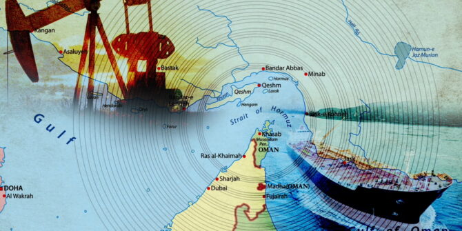
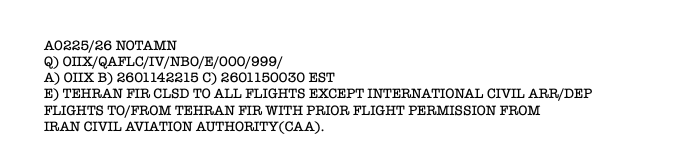
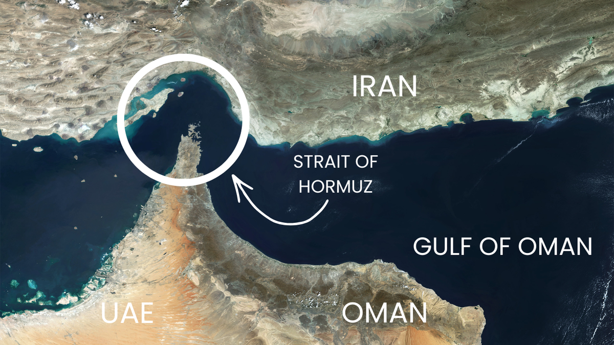
Roughly twenty percent of the world’s supply moves through the Strait of Hormuz every day. Even the threat of the route being disrupted will have a direct impact on oil prices. This is because traders immediately start pricing in the possibility that shipments may be disrupted.

That risk premium is now showing up in jet fuel.

Shortages not expected

Despite the sudden surge in prices, actual fuel shortages in the US are unlikely.

Domestic refinery capacity remains strong and the US produces large amounts of crude oil. What we’re seeing is price volatility rather than a lack of supply.

Unfortunately, this doesn’t help with our smouldering wallets. Operators will likely continue to see wide price differences between airports as FBOs adjust their inventory and contract pricing.

How to compare prices

In the current environment, it has become more important than usual to check fuel prices when filing a flight plan.

There are a few ways to make this easier:

AirNav is a useful free resource that shows posted retail fuel prices at many US airports. It pulls data from a database of more than 3,000 FBOs nationwide.

Courtesy of AirNav

If you have contract fuel through the likes of Shell, World Fuel or Colt check whether they have an app. These often show contract prices at nearby airports.

Lastly, call ahead to the FBO and avoid nasty surprises. The posted prices don’t always reflect discounts or contract rates.

How long will this all last?

Like the rest of the world, we simply don’t know.

Oil prices can rise quickly, but they can also fall just as fast. Fuel markets react rapidly to geopolitical risk and often normalise once the situation stabilises.

If tensions in the Middle East ease, prices could settle within days, weeks or months. If the conflict escalates and disrupts major oil infrastructure or shipping routes, higher prices may persist for longer.


Belgium airports impacted by another nationwide strike

Another nationwide strike is taking place in Belgium on Thursday, 12 March, and it is going to cause significant disruption at the country’s main airports EBBR/Brussels and EBCI/Charleroi.

The last major strike on 26 November did not involve ATC, but airport operations were still severely disrupted. Airlines had to cancel all departures and in some cases arrivals at both EBBR and EBCI. BizAv at Brussels saw only minor delays to services, while at Charleroi availability was still being evaluated on the day.

For the upcoming strike on 12 March, the situation is similar in terms of airport staffing. ATC involvement has not been reported, so BizAv services should remain largely unaffected despite the wider airport disruptions.

In addition to flight disruptions, significant delays to public ground transport are expected across Belgium, affecting trains and local services. Plan for potential delays getting to the airport.

Here’s what we currently know about the impact of the strike at the main airports:

EBBR/Brussels

Notam issued restricting departing flights with local passengers:

A0652/26 - AD LTD DUE TO INDUSTRIAL ACTION. FORCE MAJEURE. 
NO DEP PASSENGER FLT POSSIBLE WITH LOCAL DEPARTING PAX. 
EXC GENERAL AVIATION AND CARGO FLT

The airport has announced that no departing flights with local passengers will be possible, as severely reduced staffing levels including security personnel participating in the strike will limit passenger processing. Only cargo flights, ferry flights without crew requiring screening, and transfer-only departures where passengers remain airside are expected to operate. Arrivals may still be possible, but airlines are advised to avoid overnight transits or passengers needing re-screening.

For BizAv, the outlook is better. Local handlers report no expected disruption, as ATC is not expected to be affected by the strike.

Contact: hostess.belgium@execujet.com.

EBCI/Charleroi

The airport has confirmed a full cancellation of both arrivals and departures for airline traffic on March 12 due to strike-related staffing shortages:

A0653/26 - AD LTD DUE TO A NATIONAL INDUSTRIAL ACTION - FORCE MAJEURE, 
STAFFING LEVEL OF MANY OPR PARTNERS WILL BE SEVERELY IMPACTED. 100 PERCENT 
REDUCTION FOR ARRIVING AND DEPARTING FLIGHTS IS REQUIRED. AIRLINES 
ARE REQUIRED TO CANCEL THEIR ARRIVING AND DEPARTING FLIGHTS IN THIS TIMEFRAME.

All commercial flights will be cancelled for the day. However, based on previous similar strikes, BizAv movements may still be able to operate through the executive terminal, provided ATC remains operational.

Contact: general.aviation@charleroi-airport.com


March 2026: Afghanistan Overflight Update

Key Points
  • Read to the end for an OPSGROUP Team report from a recent flight over Afghanistan.
  • With the central Middle East corridor currently closed, a lot of Europe-Asia traffic is rerouting north via the Caucasus and Afghanistan. As a result, the OAKX/Kabul FIR is seeing significantly more overflight traffic than usual.
  • Afghanistan has recently re-issued several procedural Notams for overflights. These confirm that the entire FIR remains uncontrolled (Class G) with no ATS service available.
  • Aircraft are responsible for separation using TIBA procedures, on fixed high-level overflight contingency routes.
  • The US FAA warning still allows US operators to overfly OAKX at FL320 or above, and to use P500/G500 in the far east as low as FL300.
  • Given the current increase in traffic through the FIR, here’s a refresher on how Afghanistan overflights work and what risks you’re taking if you use it.

A Little Background

Afghanistan has been used as a transit corridor for several years now, but it’s suddenly become much busier as aircraft avoid the closed airspace between Israel and Iran. Many Europe-Asia flights are currently routing north via the Caucasus and then across Afghanistan before rejoining the normal routes toward South Asia.

The basic situation inside the Kabul FIR has not changed. The entire airspace is uncontrolled Class G with no ATC service available. Aircraft are responsible for their own separation and must follow procedural traffic broadcasts.

Afghanistan has recently re-issued several procedural Notams confirming these arrangements. They include requirements for aircraft to maintain 15-minute longitudinal spacing from preceding traffic at the same flight level and to make regular TIBA broadcasts while inside the FIR.

Separately, there has been renewed fighting between Pakistan and Afghanistan along their shared border. Cross-border strikes and increased military activity have been reported since late February.

There is no indication that civil aircraft are being targeted and airlines are continuing to operate over central Afghan airspace, but the border region with Pakistan should currently be treated as a higher-risk area.

On March 2 the UK issued an airspace warning for the OAKX/Kabul FIR related to these clashes. This appears unrelated to the Iran crisis but reinforces the long-standing point: while Afghanistan can be a useful transit corridor, it is not risk-free.

Before You Go

Before planning an Afghanistan overflight, check a few things:

  • PPR: All operators must obtain prior permission to enter the Kabul FIR. Plan for at least 72 hours. Requests are submitted to flightpermissions.acaa@gmail.com.
  • State guidance: Check airspace warnings at safeairspace.net.
  • Insurance: Confirm that your policy covers operations in uncontrolled or conflict-adjacent airspace.
  • Routing awareness: If you’re planning to use the eastern corridor near the Pakistan border (including P500/G500), note that recent clashes between Pakistan and Afghanistan mean this area carries slightly higher risk at the moment.

Overflights

The procedures to overfly the Kabul FIR have not changed – they’re found in a series of Notams recently republished and extended.

For the purposes of this article, these are the basics:

  • File only via one of the published high-level contingency routes as per the map above.
  • Expect entry spacing. Adjacent FIRs may delay entry to maintain 15-minute separation from preceding traffic at the same level.
  • Use TIBA procedures. Broadcast position and intentions on 125.2 MHz.
  • Make broadcasts regularly (including before entering the FIR and periodically while inside it).
  • Maintain your filed flight level and speed unless required for traffic avoidance or an emergency.
  • Contact the next FIR at least 15 minutes before the boundary point.
  • Keep lights and transponder on at all times.

Unplanned Landings

If you plan to overfly Afghanistan, treat a diversion there as an absolute last resort! According to all the state airspace warnings there’s a seemingly endless list of surface-to-air weaponry they might start shooting at you if you fly too low, and if you have to divert then good luck with the Taliban.

Plan fuel and ETPs so you can remain airborne and exit Afghan airspace before landing wherever possible.

If a diversion becomes unavoidable, OAKB/Kabul is the most likely option, but don’t expect much help when you get there – security and services are uncertain, and most governments advise their citizens not to travel to Afghanistan. For most operators, landing at an Afghan airport would be akin to ditching in oceanic airspace.

Our Pilot Report – here’s what we did …

There is a hefty dose of ‘at your own risk’ about all of this. The choice to overfly is not an easy one. To give you a much better idea of what to expect, here’s an OPSGROUP Team report from a recent flight over Afghanistan:

We operated through OAKX FIR on a EHAM/Amsterdam-WMSA/Kuala Lumpur flight

Overflight Permit: Getting the permit was relatively easy. We emailed flightpermissions.acaa@gmail.com (cc to flightpermission.atm@mota.gov.af) and received a response within 24 hours. They replied to us saying that to cross the airspace is charged a flat fee of $700 USD. You will need to fill out the form provided (this Excel document) and then forward that, plus copies of your Insurance, Airworthiness Certificate, and Aircraft Reg. If you are operating commercially, they also want your AOC. They ask for a minimum of 48 hours’ notice, although we put our application in a week in advance.

Insurance: Our insurance (like most) doesn’t allow operations within certain countries; however, they permit overflights on ATC-approved airways, and if you end up diverting due to an emergency, you are covered. We checked, and L750 was considered OK. Several air routes are “open.”

Routing: We had planned on L750, which runs from UTAV (Turkmenabat) to OPLR (Lahore). They also sent us the Kabul FIR Contingency Procedure document. The most important thing to read is the broadcast procedures since there is NO ATC service. The flight was very straightforward, and this route saved us a fair chunk of time and fuel.

ATC Comms: About 5 minutes before Kabul’s boundary, the UTAV controller asked us to “report ATC established with Kabul.” We tried calling Kabul on 125.2, knowing full well there was no ATC service. We told UTAV that we were going to continue TIBA procedures in Kabul FIR, and they told us, “Radar services terminated, frequency change approved. Good night.” All our external lights were switched on. We used Comm 2 as our TIBA box (125.2), Comm 1 stayed with the UTAV frequency, and Comm 3 (our data link was set to SAT) to monitor 121.5. Revise your TIBA calls; they suggest you broadcast them every 5 minutes. We used each fix, and it worked at about the right time.

Over Afghanistan: There was one aircraft departing OAKB/Kabul airport, a commercial jet on its way to Dubai, and aside from that, there was no one else. Up at FL450, we had a great view of the terrain – the word is “inhospitable.”

We could continue to hear UTAV on Comm 1 until about 15 minutes into Kabul when we switched to 124.1, the OPLR (Lahore) FIR frequency; about 15 minutes before we got to the boundary, we could hear calls from other aircraft. We had about 10 minutes of “dead” time on Comm 1.

I had an ETP using UTAV/Turkmenabat and OPIS/Islamabad and did not consider using any of the airports within Kabul FIR as available airports. This was treated just like a NOPAC or NAT crossing. There is nowhere to go, so if something eventful happens, you can keep going or turn back based on your ETP.

We checked in with Lahore about 10 minutes before reaching BIROS, and they told us to call overhead BIROS.

Key Points: It is relatively straightforward; brush up on the TIBA calls. There is more traffic nowadays as several airlines are using the routes for daytime flights, so it was a bit busier the last time I used it. However, at best, you will have a couple of airliners in the mid to high FL300s. There was no GPS Spoofing / Jamming or bad ATC, so I would use this route again, considering the other options in that region.

You experience is invaluable – if you are overflying Afghanistan and have some operational advice, please share it with the group. You can reach us on team@ops.group, or file an Airport Spy report anonymously here.


NAT CPDLC Route Uplinks: Crew Confusion and Errors

On Jan 27, the FAA published an Information Note for Operators (InFO) warning that crews have been responding to CPDLC route uplinks late or incorrectly when entering or while inside Gander’s oceanic airspace.

Aside from confusion, this has led to increased frequency congestion, controller workload, and interventions to prevent route deviations.

The InFO isn’t regulatory, but it highlights a persistent NAT issue that the FAA wants operators and training departments to address.

Here’s what’s going on.

The Backstory

It’s no surprise there’s confusion. Over the past few years, NAT oceanic procedures have changed significantly.

In 2023, the NAT began transitioning toward Oceanic Clearance Removal (OCR). Gander implemented this change, meaning crews submit a Request for Clearance (RCL) prior to the Oceanic Entry Point. If no change is required, they are considered cleared as filed. If a change is required, ATC issues a specific amended route or level.

In December 2024, Gander began issuing amended oceanic routes and levels via CPDLC following the RCL process. The goal was to standardise amendments via datalink rather than voice, and reduce readback/hearback error opportunities.

It didn’t go smoothly. Reports of confusion followed – especially around how amended routes were being issued and how they were being integrated into the FMS.

In May 2025, NAV CANADA temporarily reverted to issuing pre-oceanic entry amendments by VHF instead. However, Gander has indicated it intends to resume CPDLC route uplinks, potentially before summer 2026.

So this issue isn’t historical. It’s current – and likely to become more relevant again soon.

Crew Error

Gander has reported a significant number of uplinks that are not promptly or correctly actioned.

The typical sequence looks like this:

CPDLC route uplink sent → crew responds “WILCO” → about 5 minutes later ATC sends “CONFIRM ASSIGNED ROUTE” → crew replies with the route string (e.g. N47A RESNO 47N050W 48N040W 49N030W 49N020W MALOT GISTI).

ATC is verifying three things:

  • You received the correct clearance.
  • You loaded the correct route.
  • Your FMS matches what they issued.

The problem arises when crews respond to “CONFIRM ASSIGNED ROUTE” before the new route has actually been loaded and verified in the FMS.

In that case, the system transmits the currently active route – not the newly assigned one. That mismatch generates an alert on the controller’s side.

There’s a second issue as well: misinterpreting certain CPDLC uplinks.

UM79 “CLEARED TO [point] VIA ROUTE CLEARANCE” is not a direct-to clearance. It is a new route to that point.

UM80 “CLEARED ROUTE CLEARANCE” is not “cleared as filed.” It is a new route that must be loaded and executed.

In either case, these errors trigger something called an ‘out-of-conformance alert’ to controllers. This is when small CPDLC errors turn into big ATC workload.

The scale of the issue is not trivial. The North Atlantic Central Monitoring Agency reported 475 lateral errors in 2025 – a 71% increase over the previous year. Total errors across all categories rose 29%, to 600.

Out-Of-Conformance Alerts

Behind the scenes, Gander’s system compares what you are expected to fly with what you are actually flying.

When ATC issues an amended oceanic route or level, this info is entered into their system as a ‘reference trajectory’. Your aircraft reports its actual position and intent via ADS-C, and the system continuously compares the two.

If there is a mismatch – whether because the wrong route was loaded or the wrong route was confirmed – an out-of-conformance alert is generated.

These take time for controllers to clear, cause distraction and add to frequency congestion. These aren’t necessarily a loss of sep, but they are a big deal in busy NAT airspace to prevent potential for traffic situations.

In other words, if you reply to “CONFIRM ASSIGNED ROUTE” before loading it, you’re sending ATC your old one.

So, what does the FAA suggest?

The key takeaway is simple: load the new route, verify it matches the clearance, then confirm it.

The info note lists a bunch of useful resources to help with this, that we have re-produced below:

  • NAT Oceanic Clearance Removal Bulletin, 2023_001.
  • NAT Oceanic Errors Safety Bulletin (OESB), 2017_002, CPDLC section.
  • Advisory Circular (AC) 91-70D, Oceanic and Remote Continental Airspace Operations, paragraph 4.4.3 and Figure 4-1.
  • AIP Canada, ENR 7 North Atlantic (NAT) Operations.
  • ICAO Global Operational Data Link Document (GOLD) Reroute Procedures.

More Questions?

We’ll try and answer them. If we can’t, we’ll put you in touch with who can. You can reach us on blog@ops.group.


Delays and Diversions at TNCM/St Maarten

Several Opsgroup members have recently reported arrival holding and diversion risk at TNCM/St Maarten due to ramp congestion, despite having confirmed FBO reservations.

On Feb 18, a member reported being advised of likely holding and possible diversion while enroute. Additional reports followed from crews who operate there regularly.

Here’s what OPSGROUP members had to say:

‘On Feb 16, about two hours out were were advised by Miami that holding and possible diversion was likely due to ramp congestion. Then about 10 minutes later they changed their mind. We heard this happen to multiple aircraft on frequency with us…’

‘I flew in last week – absolutely true. There were five planes in a holding pattern when we arrived. We did four turns in a hold at GAB before being allowed to proceed to the airport. Multiple planes hit minimum fuel and had to divert to other airports. The problem is compounded when the winds shift to runway 10 and the commercial planes require runway 28. You have planes departing from both ends…’

‘We held for 45 minutes waiting for the airport to let GA aircraft land. We had everything booked for some time prior. We heard a couple GA aircraft divert to San Juan. I would strongly advise looking at the 121 schedule when planning an arrival time. There was simply no concrete left…’

‘For GA, it has been more difficult to arrive than during the Xmas/high season. We fly 2-3 times per week and have been told to land after 5pm…’

“This is common, even for airline ops. Single runway with backtracking, in addition to the limited ramp space that can seize up with a missed call or mistake, only exacerbates the compression on the field.  ATC is competent and familiar but extremely busy in these situations, so it’s advised to bring extra gas…”

“On arrival 50 miles out we were told no there was no ramp space…parking had been reserved for months. There was an AOG aircraft in our spot. We were told to divert to Anguilla, no parking after call to FBO .  Landed St.Kitts and waited until space opened in TNCM at 6 pm…”

Restriction on GA movements

A Notam issued Feb 14 may be contributing to the situation:

A0094/26 NOTAMN
Q) TJZS/QSLXX/IV/NBO//000/150/1802N06307W040
A) TNCM
B) 2602141100 C) 2603300359
E) GA IFR TFC RESTRICTED DLY TO
4 ACFT PER HOUR BTN 11:00 UTC AND 15:59 UTC
2 ACFT PER HOUR BTN 16:00 UTC AND 21:00 UTC
4 ACFT PER HOUR BTN 21:01 UTC AND 03:59 UTC
PRIOR APPROVAL REQUIRED FROM THE RESPECTIVE FIXED BASED
OPERATOR. FLIGHTS NOT APPROVED SHALL NOT BE ACCEPTED

But member reports suggest that even with PPR, arrival delays may still occur during peak periods.

Planning around peak traffic

Currently, the practical advice is simple: check the airline schedule and avoid arriving or departing when the airport is busy with Part 121 traffic.

This can be compounded when winds favour Runway 10 but heavier jets continue using Runway 28 for performance reasons.

As a starting point, there are typically two airline peaks each day at TNCM:

Peak 1 (main wave): Late morning through early evening. Arrivals surge roughly 1130-1500 LT, with departures from about 1430-1830 LT.

Peak 2 (smaller wave): A second departure push between approximately 1930-2100 LT.

So the best bet is to plan for an early morning arrival, or after about 1830 local.

Please keep reporting

Your reports are invaluable to the group – you can submit those (anonymously) via Airport Spy, or directly with the team on blog@ops.group.


World Cup 2026 Ops Guide – USA, Mexico and Canada

If you have ever planned ops around the Super Bowl, F1, or the Olympics, you already know what to expect. Hotels sell out fast, ramps fill up, and slots become critical.

Now spread that across three countries, six weeks, and 16 host cities.

The 2026 FIFA World Cup runs June 11 to July 19. With 48 teams and 104 matches, it will be one of the busiest BizAv periods North America has seen. Traffic will surge across Mexico, the US, and Canada.

Check the official FIFA match schedule below. Arrivals typically peak the day before and on match morning. Departures spike immediately after. Things ramp up fast from the Round of 32 onward.

Official FIFA schedule times are published in Eastern Time (ET). Local time at some host cities is different!

Or hover over the cities on the map below to quickly check which dates matches are happening:

Mexico

If there is one country that can break a World Cup mission before you even leave the ground, it is Mexico. AFAC permits, possible slot controls, special event fees, and chronic Mexico City congestion will make this the main access bottleneck.

If you need support with Mexico planning or permits, contact CST Flight Services at: info@cstflightservices.com.

Permits

Mexico permits are handled by AFAC. Applications are detailed, documentation must be complete, and approval timelines remain unpredictable. During the tournament, permits will be one of the main reasons flights slip.

Private flights now operate under the AIU (Single Entry Authorisation) introduced in Jan 2024. Despite the name, it is valid for 180 days and allows multiple entries and domestic legs. Processing has improved, but issuance still depends on the destination airport receiving an authorisation number from AFAC HQ in Mexico City. That can take minutes or a couple of days.

Charter permits are typically issued on a one-shot basis. Do not expect new Blanket Permits before the tournament. If you do not already have one, plan for a one-shot authorisation and start early.

For full background, see the OPSGROUP article on Mexico permits.

Slots and fees

Slot controls may tighten for the World Cup period, potentially with priority given to sponsors and VIP traffic. Special event fees are also likely, although details have not yet been published.

Match day pressure

Mexico City airspace is saturated even on a normal weekday. Expect sequencing delays, tight parking, and heavier security on match days. Host cities are Mexico City, Guadalajara, and Monterrey, with match activity starting June 11.

Mexico City (MMMX/Mexico City, Estadio Azteca) will see the biggest spikes around:

  • June 11 Kickoff match
  • June 17 Group stage
  • June 24 Group stage
  • June 30 Knockouts
  • July 5 Knockouts

Guadalajara (MMGL/Guadalajara, Estadio Akron) is busiest during the group stage:

  • June 11-26 Group stage

Monterrey (MMMY/Monterrey, Estadio BBVA) runs heavy activity through the group stage, followed by a key knockout match:

  • June 14-24 Group stage
  • June 29 Knockouts

Mexico airports: BizAv practicality

For most BizAv ops, the strategy is simple: avoid MMMX unless absolutely unavoidable and build plans around airports that can realistically support volume.

  • MMMX/Mexico City: Not an option for BizAv. Only commercial, military, and government flights are permitted.
  • MMSM/Felipe Angeles: Set to play an important role for large-body ops, with approved overnight parking available for wide-body aircraft.
  • MMTO/Toluca: The go-to BizAv airport for Mexico City positioning, open H24.
  • MMGL/Guadalajara: Capacity is improving. Universal plans to open a new FBO on April 1, with expanded ramp space and private CIQ.
  • MMMY/Monterrey: The main BizAv airport for Monterrey ops.
  • MMAN/Del Norte: Closer to the Monterrey venue than Saltillo, but more operationally complex under military control. You’ll need to balance operational complexity against drive time.
  • MMIO/Saltillo: Around one hour from Monterrey and the best geographic BizAv alternate after MMMY and MMAN. The longer ground transfer may be a limiting factor.
USA

The US will handle most of the tournament traffic, with matches across 11 host cities.

CBP and eAPIS submissions need to be accurate. Double-check passenger data and documents before filing. At busy airports, expect tighter CBP availability, especially on match days and during knockout rounds. Once traffic builds, last-minute changes will be difficult.

Security will be more visible than usual. Expect increased TSA ramp presence, credential checks, and stronger local law enforcement around stadium areas.

Slot controls are likely at major airports including KJFK/John F Kennedy, KEWR/Newark, KLAX/Los Angeles, KATL/Atlanta, and KMIA/Miami, particularly around key match days.

Tournament timeline

New York/New Jersey (KEWR/Newark, KJFK/John F. Kennedy – MetLife Stadium) will be the toughest place to operate during the tournament, especially around the Final on July 19. Expect the biggest spikes around:

  • June 13-27 Group stage
  • June 30 Knockouts
  • July 5 Knockouts
  • July 19 Final

Strong alternates include KTEB/Teterboro and KHPN/White Plains.

Around the Final, assume KEWR and KJFK will be at capacity unless parking is confirmed well in advance. If you are flexible, position early to alternates.

Slot and parking pressure will build in the days leading up to July 19.

Demand will stay high across all US host cities once the knockout rounds begin. The US has significant infrastructure and capacity, but flexibility will tighten during peak periods.

Below is a simplified operational view by city:

Atlanta (KATL/Atlanta – Mercedes-Benz Stadium)

  • June 15-27 Group stage
  • July 1, 7, 15 Knockouts

Boston (KBOS/ Boston Logan – Gillette Stadium)

  • June 13-26 Group stage
  • June 29 Knockouts
  • July 9 Quarterfinal

Dallas (KDFW/Dallas Fort Worth, KDAL/Dallas Love Field – AT&T Stadium)

  • June 14-27 Group stage
  • June 30 – July 14 Knockouts including a semifinal

Houston (KIAH/Houston George Bush, KHOU/Houston Hobby – NRG Stadium)

  • June 14-26 Group stage
  • June 29, July 4 Knockouts

Kansas City (KMCI/Kansas City – GEHA Field at Arrowhead Stadium)

  • June 16-27 Group stage
  • July 3 Knockouts
  • July 11 Quarterfinal

Los Angeles (KLAX/Los Angeles – SoFi Stadium)

  • June 12-25 Group stage
  • June 28, July 2, 10 Knockouts

Miami (KMIA/Miami – Hard Rock Stadium)

  • June 15-27 Group stage
  • July 3, 11 Knockouts
  • July 18 Third-place match

Philadelphia (KPHL/Philadelphia – Lincoln Financial Field)

  • June 14-27 Group stage
  • July 4 Knockouts

San Francisco Bay Area (KSFO/San Francisco – Levi’s Stadium)

  • June 13-25 Group stage
  • July 1 Knockouts

Seattle (KSEA/Seattle – Lumen Field)

  • June 15-26 Group stage
  • July 1, 6 Knockouts

FIFA PASS: helpful, but not a free pass

The US government and FIFA have rolled out FIFA PASS, a priority visa appointment system for World Cup 2026 ticket holders travelling to US host cities. In simple terms, it gives eligible passengers a faster way to secure their visa interview ahead of the tournament.

For BizAv operators, this may help reduce visa lead times during peak travel periods. It does not replace standard US entry requirements, so visa status should still be verified carefully. Think of it as helpful, but not guaranteed.

Special event fees

Special event fees are very likely at a number of US airports during the tournament, especially in cities hosting knockout matches and the Final. Some airports may publish details early, while others could confirm charges closer to the event, so it is worth keeping an eye on developments.

We update our US Special Event Fees overview throughout the year as new info comes in. If you hear about confirmed fees or local restrictions that are not yet on the list, let us know so we can share the update with everyone.

Canada

Canada hosts fewer matches than the US, but it can be a useful pressure valve.

If you’re arriving from Europe or repositioning between venues, Toronto and Vancouver offer a practical place to park without jumping straight into the busiest US airspace. It can work well as a staging point while you wait for a better slot window south of the border.

Factor in customs. Most BizAv arrivals require CANPASS coordination, so passenger data and timing need to be accurate.

Tournament timeline

Canada’s host cities are Toronto and Vancouver. Match activity begins early in the tournament, so expect demand from mid-June onward, even if overall traffic levels remain lower than the busiest US venues.

Toronto (CYYZ/Toronto Pearson – BMO Field) will see activity around:

  • June 12, 17, 20, 23, 26 Group stage
  • July 2 Knockouts

Vancouver (CYVR/Vancouver – BC Place) will see activity around:

  • June 13, 18, 21, 24, 26 Group stage
  • July 2 Knockouts
  • July 7 Quarterfinal

Share your experience

Are you already arranging services at any World Cup host airport? Have you run into anything unusual, unexpected, or worth flagging to other operators?

We would love to hear from you! Drop us a note at team@ops.group and let us know what you are seeing on the ground.


FAA Warns on Runway Length Data and Overrun Risk

On Jan 21, the FAA issued a new Information Note for Operators after identifying cases where incorrect runway length data was being used for performance planning.

The concern is straightforward. Using the wrong numbers can skew takeoff or landing calculations, which is why the FAA says performance planning should be based on declared distances from the Chart Supplement.

What exactly is the issue?

The FAA notes that many crews default to runway lengths taken from airport diagrams, charts, FMS databases or commercial planning tools.

The issue is that these sources may not include declared distances (TORA, TODA, ASDA and LDA) which are the figures used to meet regulatory performance requirements and can differ significantly from the physical runway length.

The FAA’s concern is that crews may misunderstand declared distances, omit them entirely, or rely on FMS or third-party data that has not been updated after changes.

So a quick clarification on how runway lengths are defined helps…

About runways

When we talk about default runway length, we are talking about the physical length of the runway surface. It’s what you see on charts, airport diagrams and other sources of info.

It represents exactly that – pavement from end to end. It may include unusable bits (such as displaced thresholds, closed portions etc) and is often a single number with no context.

It doesn’t tell you how much runway is legally available for takeoff or landing and can significantly overstate what you can actually use (more on that later).

Declared distances, on the other hand, are the official, performance-relevant runway lengths published by the airport authority via the FAA Chart Supplement and other validated sources.

A brief reminder of what these distances include (and critically, don’t):

Takeoff Run Available (TORA). Think of this as how much runway you can accelerate on. It includes useable pavement only, starting at the take-off threshold. It doesn’t include clearways or stopways.

Takeoff Distance Available (TODA). How much distance you have to get airborne (i.e. TORA) plus the distance required to clear obstacles in the initial climb segment (clearways). Crucially, it doesn’t include stopways (usable in a rejected takeoff).

Accelerate-Stop Distance Available (ASDA). Think of this of how much distance you have if you reject the takeoff. It includes TORA and stopways. It doesn’t include clearways.

Landing Distance Available (LDA). How much runway you actually have to stop after touchdown. This includes usable pavement from the landing threshold to the end of the runway. It doesn’t include pavement before a displaced threshold, stopways or clearways.

Here’s what this all looks like:

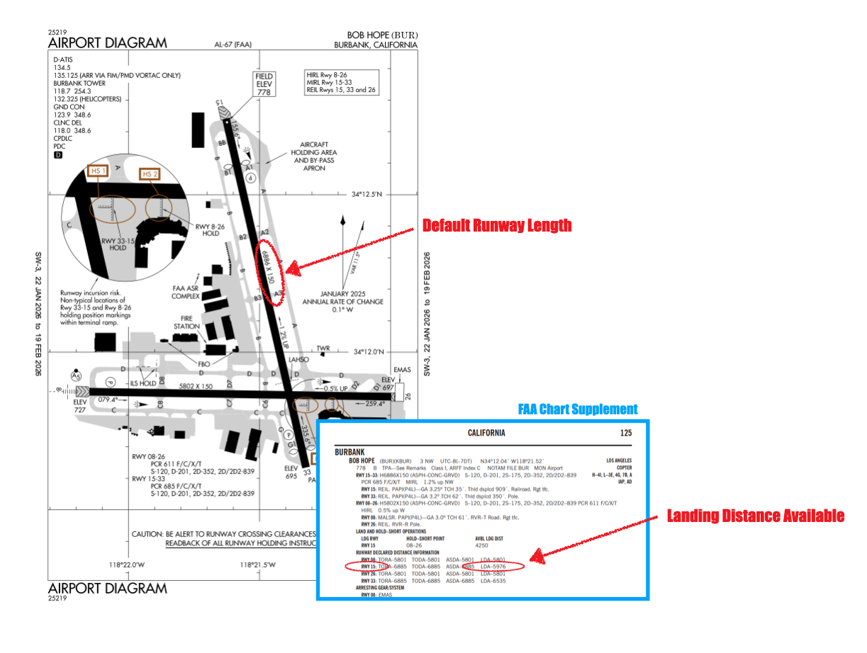
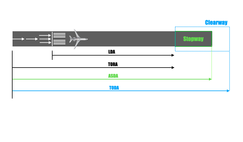
Under the FAA regs, these distances are the authoritative performance numbers. They override any single runway length shown elsewhere. That’s the key point.

Real world example

But that’s enough theory. A good real-world example is KBUR/Burbank Runway 15, where the published runway length and the declared landing distance are not the same.

Many charts and planning tools show a runway length of 6,886 ft. But the FAA Chart Supplement lists an LDA of 5,976 ft due to a displaced threshold for obstacle clearance.

If crews plan landing performance using the longer figure, they may be overestimating available runway by about 900 ft. Add tailwind, a wet surface, or a performance-limiting MEL, and that margin can disappear quickly.

That’s exactly the scenario the FAA is trying to prevent.

So what’s the FAA’s advice?

For performance calcs, the FAA says crews should use published declared distances, not the physical runway length. Just because pavement exists doesn’t mean it’s legally usable.

That expectation needs to be reflected in procedures, training and day-to-day practice.

Crews also need to be clear on which runway lengths their performance tools are actually using.

Be aware that the FMS runway length is not LDA, ASDA or TODA.

Operators should also review FMS databases and third-party performance tools, understand their limitations, and check that the data is current.

Have you spotted something risky out there?

Share it (anonymously) with the group! You can reach us via blog@ops.group, Airport Spy or Report-A-Thing.


EASA’s New Cyber and Data Risk Rule for Operators in Europe

On 22 Feb 2026, EASA brings the Part-IS Information Security regulation into force.

This is not a new avionics requirement, and not a connectivity upgrade mandate. It’s a management system rule. EASA wants certain aviation organisations to show they understand and manage cyber and data risks that could affect aviation safety.

That includes things like aircraft networks, satcom and cabin connectivity, data flows, access to systems, and how cyber incidents are handled. EASA’s view is simple: if a digital failure or attack could impact safety, it needs to be treated like any other operational risk.

The most important point up front: Part-IS only applies to organisations EASA regulates. Flying into Europe alone does not put you in scope.

What affected operators actually have to do

If you’re in scope, EASA expects a working information security management system that fits the size and complexity of your operation. Not theory, and not a one-off document exercise.

In practical terms, inspectors will expect to see that:

  • You’ve assigned responsibility: Information security sits at management level. It’s owned, not outsourced to “IT”.
  • You know what matters operationally: You’ve identified systems and data that would hurt safety or operations if compromised. That usually includes connectivity, EFB links, maintenance and planning systems, and interfaces with third parties.
  • You actively manage risk: There’s a repeatable process to identify, assess, mitigate, and review cyber and data risks. This updates when things change – new aircraft, new satcom, new apps, new vendors.
  • Basic controls are in place: Access control, configuration management, patching, backups, logging, and secure remote access. Nothing exotic, but it must exist and be used.
  • You can deal with incidents: You can detect issues, respond, recover, and learn. If an information security event could affect safety, EASA expects it to be managed properly.
  • You manage suppliers: Part-IS pushes hard on supply chain risk. Operators are expected to understand and manage information security risks across connectivity and data providers, not just internally.

Do operators have to submit anything before Feb 22?

Short answer: no. There is no blanket requirement to submit a declaration, form, or compliance statement to EASA by 22 Feb 2026.

Instead, EASA expects that from that date, your Part-IS setup exists and is actually working.

Compliance is checked through normal oversight. That means Part-IS will typically be reviewed at your next audit or inspection, during approval changes or renewals, or earlier if there’s any kind of incident or trigger event.

Bottom line: no paperwork deadline, but also no grace period. From 22 Feb, you need to be audit-ready.

Who is definitely not directly impacted

This is where most of the confusion sits.

Part-IS does not automatically apply to:

  • US Part 91 operators.
  • US Part 135 operators.
  • Privately owned foreign registered aircraft.
  • Operators with no EASA approval or certificate.
  • EASA Third Country Operator (TCO) authorisation holders.

If you don’t hold an EASA AOC, EASA has no legal way to enforce Part-IS on you.

So the common scenarios we’re hearing about:

  • A US owner flying a jet into Europe under Part 91, with no EASA approvals – no direct Part-IS compliance requirement.
  • A US charter operator flying into Europe under Part 135 and holding an EASA TCO only – again, no direct Part-IS compliance requirement.

Flying into Europe, or holding a TCO, does not by itself make an operator subject to Part-IS.

Why you might be getting emails from your connectivity provider about this

So why are operators being told “this affects you” and “you must be ready by 22 Feb”?

Because connectivity providers sit inside the compliance chain.

Their EASA-regulated customers will be audited. Auditors will ask how information security is handled end to end, including customer configurations, access rights, data routing, and system interfaces.

Providers likely don’t want two security standards, weak links in customer setups, or any awkward audit questions they can’t answer!

So they might be pushing requirements downstream via contract changes or software upgrades.

For operators outside scope, this can feel like a regulatory mandate. It isn’t. It’s commercial and risk-driven pressure, not a new EASA legal obligation.

Bottom line

Part-IS is real and it matters – for EASA-regulated organisations. For non-EASA operators, the impact is indirect, driven by vendors and contracts, not regulation.

If you don’t hold an EASA approval, Part-IS is not suddenly your problem on Feb 22. But expect more security questions from the companies you connect to.


Airport Spy: Real World Reports from Crews

Imagine having a TripAdvisor for pilots. Real-world reports from people who’ve actually been there, flown the approach, dealt with the handler, and figured out the local quirks the hard way.

That’s exactly what Airport Spy is.

Airport Spy is a shared pool of short, practical reports on airports, ATC, and ground handling around the world. It’s built from first-hand experience and written for crews who just want to know what to expect.

And it’s getting busy lately! Thanks to everyone who’s been filing reports and helping make it more useful for the next crew.

Some recent reports!

OPSGROUP members can read all reports in Airport Spy via the members Dashboard here.

Spy Reports by Pilots and Operators

You can help too!

When you’re back from a trip, or stuck in a hotel downroute with time to kill, take a couple of minutes to file an Airport Spy report. What you write might save the next crew a lot of hassle.

These reports are useful when you go back, but they’re even more useful for crews heading somewhere for the first time.

Good reports don’t need to be long. Think about what you’d want to know before turning final or shutting down on stand. For example:

  • How was ATC to work with?
  • Anything unusual about the airspace, terrain, or procedures?
  • Local quirks or gotchas?
  • Handling quality and coordination?
  • Anything better or worse than expected?

If it stood out to you, it’ll probably matter to someone else.

Pilots and Operators can file a report here!

Spy Reports by FBOs and Handlers

Airport Spy isn’t just for crews – FBOs and handlers can file reports too. Before we launch your way, we want to know what’s really going on.

Are you open? Ops normal? Any new rules, restrictions, or changes crews should know about before they arrive?

Just imagine a crew is thinking of heading your way. They’ll have some basic data, but a report with the latest situation is really helpful. Useful topics include:

  • Airport and ATC hours
  • New rules or restrictions
  • Entry or permit issues
  • Any recent changes
  • Local tips, quirks, or common traps for first-timers

Once filed, your report goes straight to the OPSGROUP community of thousands of pilots, dispatchers, and operators.

FBOs and Handlers can file a report here!

Why bother?

Because this is what OPSGROUP has always been about. Sharing real information. Speaking plainly. Helping each other out. Keeping each other safe.

If we share, we keep each other safe. That means that if you come across a new risk, a new danger, a new procedure, something weird, something unusual – tell us, and we’ll tell everyone in the group.


New NAT Doc 007: North Atlantic Changes from March 2026

A new NAT Doc has landed, effective 19 March 2026. As ever, it’s a meaty sucker, and probably not something you’ll want to read cover to cover. So we’ve done that part for you. We’ve gone through it and pulled out the changes that actually matter operationally, plus a few important “this hasn’t changed” reminders. If you’re crossing the North Atlantic, this is the stuff worth knowing.

You can access the new 2026 version of the doc here, and the old 2025 version here, if you want to compare the two.

Shanwick OCR delay

The new NAT Doc now clearly states what operators have known for a while: Shanwick has not implemented Oceanic Clearance Removal. A specific note states that, due to delayed OCR implementation, Shanwick will continue issuing oceanic clearances following submission of an RCL, until further notice.

The document itself does not give a timeline. However, Shanwick has separately confirmed that OCR is not expected to go live before summer 2026. Operationally, nothing changes at Shanwick for now – crews must still request and fly an oceanic clearance. The key point is that, despite much of Chapter 6 reading like an OCR-style environment, Shanwick is explicitly not there yet.

Ref: Chapter 6, Section 6.3.

RCL timing switches from ETA to ETO – new terminology

The new 2026 edition introduces ETO – Estimated Time Over Significant Point for the Oceanic Entry Point in RCLs, replacing the way ETA was used in previous editions.

Doc 007 doesn’t explicitly explain the change, but the logic is pretty clear. ETA can be vague and is often taken as a general arrival estimate. ETO is much more precise – it’s the FMS-predicted time over a specific waypoint. That’s what ATC actually uses for longitudinal separation in procedural airspace.

The shift also lines up with two big themes in the new doc: the move toward OCR-style operations, and growing concern about time accuracy after GNSS jamming and spoofing.

Ref: Chapter 6, Sections 6.3.23-6.3.25

Reykjavik no longer requires an RCL

Reykjavik effectively steps away from the RCL process altogether in the 2026 edition. Doc 007 now says that an RCL is not required for Reykjavik, and that if one is sent anyway, crews will be told it wasn’t needed.

The main issue with RCL was confusion with some crews about what it actually meant. In some cases, crews assumed that once they’d sent it, they could climb or descend to the level in the message without first receiving an ATC clearance. So Reykjavik have decided to discontinue RCL altogether for safety reasons.

Other NAT OCAs still require RCLs, so this doesn’t simplify things overall. It just means procedures are even more mixed than before. The main risk for operators is assuming the same process applies everywhere across the NAT, when it very much doesn’t!

Ref: Chapter 6, Section 6.3.24

Bigger push on FMS waypoint and route verification

The 2026 doc puts much more weight on careful FMS programming and verification. It highlights known traps with half-degree waypoints, ARINC 424 coding, and CPDLC route amendments that arrive in full LAT/LONG and don’t visually match stored waypoint names.

There’s a strong emphasis on independent PF/PM crosschecks and verifying expanded coordinates, courses, and distances. This isn’t theoretical – it’s a direct response to navigation errors seen since OCR and more frequent CPDLC route changes.

Ref: Chapter 6, Sections 6.3.18-6.3.32

GNSS interference treated as a routine NAT problem

GNSS jamming and spoofing are no longer treated as rare edge cases. In the 2026 doc, they’re framed as a normal operational hazard. The guidance highlights how GNSS interference can quietly degrade aircraft time, with knock-on effects to ADS-C, ADS-B, CPDLC, and longitudinal separation – even after position accuracy appears to have recovered.

The practical takeaway is simple: “it recovered” doesn’t mean “it’s fine”. So operators need to think about downstream impacts before entering the NAT. More detailed guidance is in NAT Ops Bulletin 2025-001, which sets out what to watch for and what to do if you’re entering the NAT with GPS problems. This mainly affects westbound flights coming out of spoofing or jamming areas. Bottom line – tell ATC early in your RCL if there are any issues. Doing so can help avoid off-track reroutes, step-downs, and delays.

Ref: Chapter 1 and Chapter 6 (Plus referenced NAT Ops Bulletin as above)

Flight Level Allocation Scheme (FLAS) – now gone

Until now, NAT Doc 007 included a Flight Level Allocation Scheme (FLAS). It was a simple table that gave crews and dispatchers a sensible planning starting point for random routes outside the OTS, mainly by biasing eastbound and westbound traffic onto different flight levels. It wasn’t mandatory, but if you planned within FLAS, you were usually aligned with what ATC expected.

In the March 2026 edition, FLAS has quietly disappeared. The attachment has been removed and there’s no replacement scheme. Instead, the new wording says that random-route flights can plan any flight level, as long as it works with traffic flows and ATC can make it fit. 🤔

So there’s nothing in the new Doc to say that the old FLAS separation logic has disappeared – it’s just no longer explicitly written down! We’re guessing the practical impact will be less predictability up front and more tactical level changes, especially if you’re flying counter-flow or close to track changeover times.

What didn’t change

Despite all the discussion around NAT procedures lately, the new NAT Doc does not introduce new requirements in several key areas:

  • NAT HLA approval is still required (though there was some chatter about this last year)
  • CPDLC and ADS-C mandates are unchanged
  • No new equipage requirements
  • No new separation standards

So the real changes here are about clarity, procedures, and reducing error, not new boxes to tick.

Ref: Chapters 1, 5, and 6

So what do crews actually do now? (RCLs and oceanic clearances, made simple)

Even when the 2026 version takes effect in March, OCR will still be uneven across the NAT, so procedures depend on which OCA you’re entering. Here’s what crews will need to do at Gander, Shanwick, and Reykjavik:

Eastbound via Gander (no change)

Gander is fully in OCR mode. You still send an RCL 90-60 minutes before the OEP, but it’s for planning only. You are not asking for an oceanic clearance, and none will be issued. Fly your last domestic clearance unless ATC gives you a change before the OEP. Once oceanic, expect any further changes via CPDLC or HF. This is the area that caused most of the early confusion, but the rule is simple: RCL yes, oceanic clearance no.

Westbound via Shanwick (no change… yet)

Shanwick is not on OCR yet. You must send an RCL or make a voice clearance request 90-30 minutes before the OEP, and you will receive an oceanic clearance by ACARS or voice. Fly that clearance. NAT Doc 007 confirms this will continue until further notice. Shanwick has separately said OCR is not expected until sometime after summer 2026.

Departing Iceland (changes from March 2026)

From 19 March 2026, Reykjavik will not require an RCL. If you send one anyway, they’ll tell you it wasn’t needed. Departing from BIKF/BIRK, you’ll enter the Reykjavik OCA on your existing ATC clearance unless instructed otherwise.

What the NAT Doc does not spell out is what happens next for flights leaving Reykjavik and entering either Gander or Shanwick!

We’ve asked Gander and Shanwick directly to confirm what the deal will be, and here’s what they’ve said:

  • Eastbound flights entering Shanwick: No additional RCL or oceanic clearance is required. Iceland will coordinate electronically with Shanwick, so crews should not expect to request a clearance or submit an RCL when exiting Reykjavik into Shanwick. This is similar to how flights entering Gander from New York FIR are handled today.
  • Westbound flights entering Gander: The same applies. Flights transitioning from Reykjavik into Gander will do so via electronic coordination between Iceland and Gander. An RCL is not required in this case. Gander RCLs are only required for flights transitioning directly from a Canadian domestic agency into Gander Oceanic.

In short: if you’re coming out of Reykjavik, don’t add an extra step. The handoff to both Shanwick and Gander will be coordinated automatically.

Other NAT Doc changes spotted by OPSGROUP members!

Thanks to everyone who wrote in with extra details they’d spotted in the new NAT Doc! A few of these aren’t brand-new changes, but they’re easy to miss and worth flagging. Here’s a round-up of the most useful bits members sent in.

  • WATRS terminology unchanged: The NAT Doc still uses the term WATRS and continues to defer the details to the US AIP. This hasn’t been updated, despite the FAA having moved to “WAT” terminology in its own AIP.
  • Squawk 2000 timing (10 minutes after OEP): This wasn’t new in the 2026 NAT Doc, but we missed it in our write-up back in 2025 so it’s worth flagging here! The NAT Doc says aircraft should retain the last assigned SSR code and squawk 2000 10 minutes after passing the oceanic entry point, everywhere in the NAT except when operating in the Reykjavik CTA or when transitioning Bermuda radar, where assigned codes are retained due to radar coverage. (Some older guidance and legacy SOPs often referred to squawking 2000 after 30 minutes, particularly in New York OCA.)
  • WAH reports no longer treated as mandatory: The updated Doc removes earlier ambiguity around “When Able Higher” reports. WAH is now clearly optional unless ATC specifically requests it, aligning with how several FIRs have already been operating.
  • SLOP still treated as a blanket NAT procedure: The NAT Doc continues to describe SLOP as standard NAT practice and does not list route-specific or FIR-specific limitations. In practice, some published ATS routes and oceanic areas have local procedures that restrict the routine use of automatic offsets. Examples include T9 and T290, which are treated as RNP 2 continental offshore routes in the UK AIP, and parts of the WAT structure in New York OCA, where procedures expect aircraft to remain on the cleared route unless otherwise instructed. These nuances come from State AIPs rather than the NAT Doc, so crews still need to check local rules before applying SLOP.
  • Magnetic variation tolerance still inconsistent: A new note highlights that magnetic variation tables and track reference points can shift displayed tracks by up to ±3 degrees. However, nearby guidance still refers to ±2 degree tolerances, and earlier numeric tolerances have been removed from the sample checklist, leaving some internal inconsistency.
  • Oceanic checklist partly modernised: The sample oceanic checklist removes the old taxi groundspeed check, which no longer makes sense for modern navigation systems. However, the present-position check remains, even though its operational value is limited on newer aircraft.
  • RCL maximum level wording updated: The recommended RCL format for requesting a maximum flight level is now “MAX FL380”, replacing the older “MAX F380” wording. Some State AIPs still show legacy formats, so crews may see differences.
  • Azores departures – no RCL to Santa Maria: If you’re departing from the Azores, you don’t need to send an RCL to Santa Maria. This exemption has been in place since 201, but it isn’t clearly reflected in NAT Doc 007. It’s published in Portugal AIP ENR 1.1.15.1.
  • Some Santa Maria local procedures still sit outside the NAT Doc: The NAT Doc applies a generic NAT baseline to Santa Maria, but several Santa Maria-specific procedures only live in the Portugal AIP. These include squawk handling in the surveillance area, limits on routine offsets in some sectors, exemptions from voice position reports when space-based surveillance is in use, and CPDLC-related SELCAL and RCL differences. None of this is new, but it still isn’t captured in Doc 007. Bottom line – don’t rely on the NAT Doc alone for Santa Maria.
Anything we missed?

Spotted any other big changes in the new NAT Doc that we missed? Please let us know, and we will update this article! Email: news@ops.group


Guided Visuals: What They Are and Why They’re So Useful

I remember the first time I tipped over on a visual approach to Runway 34 at the waypoint SHEED at YMML/Melbourne. The northerly was howling, we were heavy, and in continuous moderate turbulence. Things were busy, but under control.

At the commencement of the visual segment, we were level at 2500’ and partially configured to fly a normal decelerated, 3-degree approach. Local operators know you need closer to 4 to find ‘the groove’ by the stable call at 1000 feet. The trouble was, we weren’t local.

Instantly it became apparent 3 degrees would not be enough. The ‘bouncy ball’ (an Airbus acronym for vertical path indicator) immediately showed we were high.

And just like that, we were chasing.

Jet operators are accustomed to this ol’ chestnut: you can’t slow down and go down. Generally speaking, it’s one or the other. We were now trying to do both.

And then came the turn to final.

We disregarded Melbourne’s secondary airport to our right, with its name emblazoned brightly in white next to the runway so as to avoid any potential confusion (it has happened). As we struggled to configure and complete our landing checklist, workload soared. The final turn came late and required the maximum angle of bank our stabilised approach criteria allowed.

As we turned into 40kts of wind on the nose, our fate was sealed – the auto thrust (by design) applied a fist full of power to compensate for our falling groundspeed, and three whites on the PAPI quickly became four.

We were done. Out of altitude and out of time, we called unstable and commenced the go-around wandering how two competent pilots had let this get the best of us.

Moral of the story – visual approaches (when unfamiliar) aren’t easy. They’re supposed to be, but they’re not.

And business jet operators are the leaders in operating high-performance aircraft to unfamiliar airports.

Enter the guided visual.

Guided visuals make use of the FMS to provide guidance that keeps you on profile and track, reducing pilot workload and allowing you spare capacity to watch for other traffic, configure and all the other pilot-y things we need to do.

But it’s important you’re familiar with their limitations – and what responsibilities still lie with you.

Let’s take a closer look…

Guided Visual 101

It helps to frame what we’re talking about here.

Guided visual approaches are visual approaches flown with lateral and vertical guidance generated by the FMS. Think of it as an assisted visual approach, backed up by RNP-AR style vertical and lateral guidance.

Important point: you’re still flying a visual approach, in VMC, to a runway that’s in sight. But instead of eyeballing things, the box builds you a stabilised path to the threshold.

You can fly it like any other automated approach with full situational awareness. It’s computerised magic, but with some fairly strong caveats (more on that in a bit).

Why they’re so useful

Firstly because they’re so stable. Guided visuals reduce the need for ‘dive and drive’ visuals. You get a proper descent profile early, which enables you to manage energy with far fewer last minute flight path adjustments. They are smart and can take into account the various vertical profiles for different segments of the approach.

Take WSSL/Seletar Runway 03: the initial descent path from SETHI starts at 4.4 degrees until turning final at 410′ where the descent shallows out to match the PAPI at 3.2 degrees, and since there is a runway point in the FMS, the aircraft can remain coupled until it reaches its autopilot limitation altitude (200′ in a Gulfstream for instance).

Then there’s workload – the FMS empties your capacity bucket by managing your geometric flight path, leaving room to focus on things like spacing, configuration, checklists and monitoring. This is especially pertinent when cleared via a visual approach while still high, fast or under (shall we say) ‘less than optimal’ radar vectors.

Then there are visual illusions caused by flat light, water, sloping terrain or black hole effect. Our eyes are known to play tricks on us.

Finally, the elphant in the room – automation. Modern, complex aircraft are designed to be flown with high levels of automation. Whether or not this is a good thing is a can of worms that falls beyond the scope of this article. But automation is well and truly engrained in how we operate modern, complex aircraft.

It’s hard to argue that when managed well (and not used as a replacement for core piloting skills), autopilot and flight director coupling provides significant safety margins compared to simply flying by the seat our pants.

But, beware…

Rubbish in, rubbish out. The guidance an FMS provides is only as good as the data it uses, and so database accuracy matters. A displaced threshold for instance may not be captured. Always, always cross-check your approach against visual cues such as PAPI.

It’s also important to remember that obstacle clearance is on you. It’s still a visual approach. Your FMS doesn’t know about obstacles, cranes or even the ‘steel structures and silos’ that you must spot on approach to WSSL/Seletar, for instance.

Singapore’s Seletar Runway 03 RNAV-H

What’s the bottom line? Guided visual approaches do not replace good visual flying. But they do help make it safer, more stable and more consistent. For BizAv operators flying to diverse airports, they can be one of the most useful tools in the box – provided they are understood.

What about legalities?

In the US, a guided visual approach is still a visual approach under FAA rules. The FAA previously issued this Information for Operators (InFO) to that effect, and is an important read before flying any guided visual.

Don’t confuse them with instrument approaches – even if the charts appear similar. “Looks like an approach” doesn’t equal “is an approach.”

In other words, the presence of flight director and autopilot guidance does not change anything.

There is no such thing as an ‘instrument visual approach.’

Visual approaches have no published minima. There is no FAA obstacle clearance protection, no TERPS validation or any other underlying regulatory protections. The same applies in the ICAO world, whilst you might have access to the visual guided approach, it is still legally a visual approach, don’t let the chart fool you into thinking otherwise.

You must:

  • Maintain continuous visual reference with the runway or traffic.
  • Be able to land using normal manoeuvres.

The FAA doesn’t specify whether you need to be head’s up or down – just as long as you remember that these remain your responsibility.

Another important clarification is that most guided visual approaches are proprietary, in other words not published via AIP. Avoid potential confusion by not using using weird naming conventions (such as “RNP-H”) that might not be immediately evident to the controller that has cleared you for a visual approach.

If you are specifically asked by ATC if you will be tracking via a procedure however, it is okay to say so. At several US airports ATC have been actively involved in procedural design. This highlights the benefits of these types of approaches, not just for pilots but for controllers too. They can help remove the “some fly wide, some fly close” factor which is common in a visual approaches.

And finally there is this important caveat. Flying one of these RNAV H or RNAV G procedures does not relieve the pilot of their responsibilities of right-of-rule rules – especially at uncontrolled airports where pattern rules still apply (see CFR § 91.113). The NBAA report that they are receiving increasing reports of turbine aircraft using instrument approaches to complete visual arrivals and (either intentionally or unintentionally) disregarding right-of-way rules with other aircraft. It’s important to understand that using these procedures does not grant any extra priority. 

Where do you find them?

In the US, guided visual approaches are not usually published procedures.

Instead third party vendors produce ARINC-424 coded procedures that can be used in your jet’s FMS. Just like an RNP-AR, you should not modify waypoints on the approach, since this could affect the jets trajectory.

When loaded, they usually appear in your FMS as ‘RNAV-H RWY XX’  or ‘RNAV-G RWY XX’ depending on which avionics package you are flying with.

Honeywell appears to be leading the charge. They have designed a number of them which, at the moment, are only available to aircraft with Honeywell avionics. Although we have been told that the data may soon be licensed to other avionic manufacturers the likes of Collins etc. Watch this space.

Garmin has also recently started to add some Visual Guided procedures to their products as well. While the number of airports served is less than the Honeywell offering, their offering is growing quickly

Have more to add?

Let us know! You can reach the team via blog@ops.group.


Singapore Ops Update: Two New Rules to Know Before You Go

If you’re planning ops to Singapore this year, expect it to be busier than ever. Traffic into Singapore exceeded previous records last year, and slots and parking are already harder to secure than they used to be.

In addition to the capacity challenges, there have also been changes to immigration and operator procedures that can catch you out if they’re not on your radar. They’re not complicated, but they do mean doing things earlier than before. These include the new No-Boarding Directive (NBD) for passengers and updated requirements around the Singapore Foreign Air Operator Certificate (FAOC).

NBD – No-Boarding Directive

Effective 30 Jan 2026, all operators (private or commercial) must check passengers in advance for a clearance (or refusal) to enter Singapore.

You can check the official announcement on this here. The process sounds more complicated than it really is. In the past, passengers who were denied entry would only be identified after arrival, once immigration determined they were ineligible to enter Singapore. This could be due to a lack of visa, being assessed as an undesirable or prohibited traveller, or a red flag arising from their SG Arrival Card submission.

Previously, the system waited until the passenger was already on Singapore soil, which was always somewhat counter-intuitive. From 30 January, however, an operator must receive confirmation that a passenger is cleared to enter (effectively a green light). If you carry a passenger into Singapore without this clearance (even if that passenger ultimately would have been approved) the operator is liable for significant penalties under the Immigration Act.

So what do you need to do?

As the operator, your role is actually very simple. You must submit your general declaration / passenger manifest to your agent or handler ahead of departure. Current guidance is no later than two hours before departure. This allows the handler to submit the passenger details via a dedicated ICA portal.

That portal will return one of two responses: “OK to Board” or “Do Not Board.”

The key takeaway is this: you must receive one of these two responses before departure. In this case, no news does not mean good news.

The upside is that operators do not need access to the portal themselves (and cannot access it anyway). Everything is handled by your agent. Your only responsibility is to ensure the passenger manifest is submitted in good time before departure.

FAOC – Singapore Foreign Air Operators Certificate

In Singapore, any foreign AOC holder (Part 121 or Part 135) must apply for a FAOC – a local validation of your AOC – via the Flight SG portal.

Allow at least several weeks for approval. Initial FAOCs are typically issued with a relatively short validity period (often around 3-6 months), with longer validity possible on renewal. In practice, first-time applications can take longer than expected, so plan well ahead.

The FAOC itself is not new. What has changed is the introduction of ANR-129, now in force, which replaces the previous FOSP (Foreign Operator Surveillance Programme) and associated permit rules.

So what does ANR-129 change?

Any aircraft listed on an AOC must now hold both a valid FAOC and a permit to operate into Singapore. CAAS no longer exempts ferry, positioning, or “private” flights if the aircraft is on an AOC.

The only operations exempt from the FAOC requirement are true private aircraft (Part 91 / CAT 2) and certain emergency situations. Overflights are also exempt. This means that any AOC aircraft (even on a maintenance visit or owner-only flight) must still hold a FAOC.

CAAS is actively enforcing this. Ramp checks are routine, and operators may see increased scrutiny around FAOC issuance and renewal. Ground handlers are also checking FAOC status before confirming slots.

The FAOC application process is well documented on the CAAS website, so the key takeaway is simple: apply early and expect admin overhead.

For a real-world example of how this works in practice, see this report from an OPSGROUP member.

More info on Singapore ops

If you’re flying a bizjet into Singapore, WSSL/Seletar is your only option. Our recent guide covers the key survival tips – from managing the visual-only arrivals to dealing with limited parking and other quirks that can catch you out. OPSGROUP members can access the guide via your members dashboard here.


Crisis in Iran: Elevated Airspace Risk

Key Points:
  • Iran remains highly unstable, with elevated risk to civil aviation.
  • Severe internet disruption has been in place since Jan 8, with broader communications affected.
  • The OIIX/Tehran FIR was closed at short notice for several hours on Jan 14, with no public explanation.
  • EASA recommends avoiding Iranian airspace at all levels due to misidentification risk.

Situation in Iran

Beginning in late December, large-scale political protests spread across major cities due to a worsening economic crisis.

These escalated in recent weeks, with many demanding a change of political leadership. The Government has responded with a violent crack-down. Large numbers of casualties have been reported amid arbitrary arrests and severe internet disruption since Jan 8, with wider communications also affected.

Several countries (including the US) have urged their citizens to leave the country immediately.

Potential for US Military Intervention

In response to humanitarian concerns, the US Government has implied military intervention remains a possibility should violence against protesters continues.

If this were to occur, Iran has repeatedly warned it will retaliate by targeting US military bases and other assets throughout the region.

Some effects of this threat have already been felt, including the partial removal of personnel as a precautionary measure at Al-Udeid Air Base in Qatar – the largest US military base in the Middle East. Although the threat level has reportedly been downgraded in the past few days.

Airspace Risk

The current crisis has further increased risk to aircraft operating in or near Iranian airspace (the OIIX/Tehran FIR).

On Jan 14, the following Notam was issued unexpectedly closing the OIIX/Tehran FIR for several hours overnight, with no public explanation from Iranian authorities:

Previous events have shown that these types of closures can occur when security or military activity is taking place including a risk of missile launches or air defence operations.

Then on Jan 16, EASA upgraded its warning for Iranian airspace by publishing a new Conflict Zone Information Bulletin (CZIB) for Iran and neighbouring airspace. It suggests that recent events (including the possibility of foreign intervention) have likely placed air defence systems at a heightened sense of alert. Civil aircraft are at increased risk of misidentification.

It’s worth noting that most operators already avoid Iranian airspace. Several states (including the US, UK, France, Canada and Germany) either actively prohibit or at least strongly advise against entering. At safeairspace.net, we maintain a ‘Level 1 – Do Not Fly’ warning.

However, when referencing adjacent airspace, things become a little more ambiguous. EASA’s CZIB advises caution when overflying neighbouring countries where US military assets are present. This notably includes Qatar, Bahrain, Kuwait, the UAE, Saudi Arabia, Jordan, Iraq, Syria and Turkey.

Special care should be used on the major air corridor that skirts the western boundary of Iran via Iraqi airspace (airways UL602, UM860 and UM688) where GPS interference (including the more insidious spoofing) is prevalent.

We know of at least one incident in the past where an aircraft almost inadvertently strayed into Iranian airspace without a clearance while suffering from navigation error.

From a broader perspective, EASA are also alluding to the possibility of regional escalation should the situation deteriorate – especially in the event of retaliatory strikes against military targets.

Continue to monitor the situation

Iran sits alongside the main Europe-Middle East transit corridor via Iraq/Kuwait/Bahrain, and the June 2025 Israel-Iran missile exchange showed how quickly events inside Iran can trigger widespread airspace closures and warnings across the region.

If further military activity involving Iran escalates, expect little warning – for Europe-Middle East flights, the longer routing via Egypt/Saudi has been the more stable option and keeps you further clear of Iranian airspace.

We’ll continue to issue any updates via Opsgroup and Safeairspace.net. You can also reach us at blog@ops.group if you have any info to share.


Greece Winter Runway Closures

Key Points
  • Several airports in Greece will be affected by winter runway works through to the end of March.
  • These include: LGZA/Zakynthos, LGKF/Kefalonia, LGKR/Corfu, LGMK/Mykonos, LGSR/Santorini, LGRP/Rhodes, LGSK/Skiathos, LGTS/Thessaloniki, LGSA/Chania, LGIR/Heraklion and LGMT/Mytilene.
  • Expect a mix of recurring weekly closures and day to day restrictions, and in many cases reduced runway distances. At some airports, declared distances are down to around 1400m, which will rule out certain aircraft types altogether.

Greek Airports with winter closures.

You can find all the details on the Notams, but here’s a quick rundown of the planned closures and reductions in runway lengths:

LGZA/Zakynthos
Full Runway Closure: RWY 16/34 closed from Feb 2-17.

LGKF/Kefalonia
Full Runway Closure: RWY 14/32 closed at various times on different days until Jan 30. Times vary daily but mostly around midday, up to 4 hrs.

LGKR/Corfu
Full Runway Closure: RWY 16/34 closed from Jan 12-27.

LGMK/Mykonos
Shortened Runway: RWY 16 reduced to 1400m, RWY 34 reduced to 1400m until Mar 25.
Full Runway Closure: RWY 16/34 closed Tuesday through Wednesday nights on a recurring weekly basis until Mar 19.

LGSR/Santorini
Shortened Runway: RWY 15 reduced to 1802m, RWY 33 reduced to 1874m until Feb 25.
Full Runway Closure: RWY 15/33 closed from Jan 12 to Jan 20.

LGMT/Mytilene
Full Runway Closure: RWY 14/32 closed every Tuesday all day until Mar 25.

LGRP/Rhodes
Shortened Runway: RWY 06 reduced to 1900m, RWY 24 reduced to 1900m until Mar 25.
Full Runway Closure: RWY 06/24 closed on a recurring weekly basis, typically from Tuesday evening until late Wednesday evening until Mar 25.

LGSK/Skiathos
Full Runway Closure: RWY 01/19 closed for most of January, with only short morning or afternoon reopening windows on certain days, until Feb 1.

LGTS/Thessaloniki
Full Runway Closure: RWY 16/34 closed from Jan 19 to Mar 6. RWY 10/28 remains in use.

LGSA/Chania
Shortened Runway: RWY 11L/29R reduced to 1900m until Mar 27, with RWY 29R threshold displaced. Straight-in minima are not authorised (circling only). RWY 29R approach lights are out of service.

LGIR/Heraklion
Full Runway Closure: RWY 09/27 closed from Jan 19-26 due to resurfacing works. Operations are on RWY 12/30 for day ops only, limited to Code letter B aircraft (incl. ATR42/72). IFR arrivals are suggested via RNP RWY 27, then visual or circling. If visibility drops below 10 km or ceiling below 2000 ft, arriving aircraft must fly VFR.


Further closures may be announced beyond the end of March – check on Fraport’s homepage for updates.

Have you operated into Greece during the winter recently? How was it on the ground, and did anything catch you by surprise?
If you have tips, experiences, or useful local insight to share, we would love to hear from you. Drop us a note at team@ops.group!