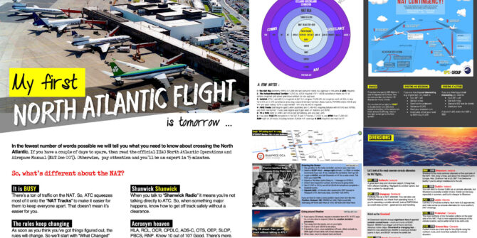
New NAT Doc 007: North Atlantic Changes from March 2026

A new NAT Doc has landed, effective March 2026. As ever, it’s a meaty sucker, and probably not something you’ll want to read cover to cover. So we’ve done that part for you. We’ve gone through it and pulled out the changes that actually matter operationally, plus a few important “this hasn’t changed” reminders. If you’re crossing the North Atlantic, this is the stuff worth knowing.

You can access the new 2026 version of the doc here, and the old 2025 version here, if you want to compare the two.

Shanwick OCR delay

The new NAT Doc now clearly states what operators have known for a while: Shanwick has not implemented Oceanic Clearance Removal. A specific note states that, due to delayed OCR implementation, Shanwick will continue issuing oceanic clearances following submission of an RCL, until further notice.

The document itself does not give a timeline. However, Shanwick has separately confirmed that OCR is not expected to go live before summer 2026. Operationally, nothing changes at Shanwick for now – crews must still request and fly an oceanic clearance. The key point is that, despite much of Chapter 6 reading like an OCR-style environment, Shanwick is explicitly not there yet.

Ref: Chapter 6, Section 6.3.

RCL timing switches from ETA to ETO – new terminology

The new 2026 edition introduces ETO – Estimated Time Over Significant Point for the Oceanic Entry Point in RCLs, replacing the way ETA was used in previous editions.

Doc 007 doesn’t explicitly explain the change, but the logic is pretty clear. ETA can be vague and is often taken as a general arrival estimate. ETO is much more precise – it’s the FMS-predicted time over a specific waypoint. That’s what ATC actually uses for longitudinal separation in procedural airspace.

The shift also lines up with two big themes in the new doc: the move toward OCR-style operations, and growing concern about time accuracy after GNSS jamming and spoofing.

Ref: Chapter 6, Sections 6.3.23-6.3.25

Reykjavik no longer requires an RCL

Reykjavik effectively steps away from the RCL process altogether in the 2026 edition. Doc 007 now says that an RCL is not required for Reykjavik, and that if one is sent anyway, crews will be told it wasn’t needed.

Other NAT OCAs still require RCLs, so this doesn’t simplify things overall. It just means procedures are even more mixed than before. The main risk for operators is assuming the same process applies everywhere across the NAT, when it very much doesn’t!

Ref: Chapter 6, Section 6.3.24

Bigger push on FMS waypoint and route verification

The 2026 doc puts much more weight on careful FMS programming and verification. It highlights known traps with half-degree waypoints, ARINC 424 coding, and CPDLC route amendments that arrive in full LAT/LONG and don’t visually match stored waypoint names.

There’s a strong emphasis on independent PF/PM crosschecks and verifying expanded coordinates, courses, and distances. This isn’t theoretical – it’s a direct response to navigation errors seen since OCR and more frequent CPDLC route changes.

Ref: Chapter 6, Sections 6.3.18-6.3.32

GNSS interference treated as a routine NAT problem

GNSS jamming and spoofing are no longer treated as rare edge cases. In the 2026 doc, they’re framed as a normal operational hazard. The guidance highlights how GNSS interference can quietly degrade aircraft time, with knock-on effects to ADS-C, ADS-B, CPDLC, and longitudinal separation – even after position accuracy appears to have recovered.

The practical takeaway is simple: “it recovered” doesn’t mean “it’s fine”. So operators need to think about downstream impacts before entering the NAT. More detailed guidance is in NAT Ops Bulletin 2025-001, which sets out what to watch for and what to do if you’re entering the NAT with GPS problems. This mainly affects westbound flights coming out of spoofing or jamming areas. Bottom line – tell ATC early in your RCL if there are any issues. Doing so can help avoid off-track reroutes, step-downs, and delays.

Ref: Chapter 1 and Chapter 6 (Plus referenced NAT Ops Bulletin as above)

Flight Level Allocation Scheme (FLAS) – now gone

Until now, NAT Doc 007 included a Flight Level Allocation Scheme (FLAS). It was a simple table that gave crews and dispatchers a sensible planning starting point for random routes outside the OTS, mainly by biasing eastbound and westbound traffic onto different flight levels. It wasn’t mandatory, but if you planned within FLAS, you were usually aligned with what ATC expected.

In the March 2026 edition, FLAS has quietly disappeared. The attachment has been removed and there’s no replacement scheme. Instead, the new wording says that random-route flights can plan any flight level, as long as it works with traffic flows and ATC can make it fit. 🤔

So there’s nothing in the new Doc to say that the old FLAS separation logic has disappeared – it’s just no longer explicitly written down! We’re guessing the practical impact will be less predictability up front and more tactical level changes, especially if you’re flying counter-flow or close to track changeover times.

What didn’t change

Despite all the discussion around NAT procedures lately, the new NAT Doc does not introduce new requirements in several key areas:

  • NAT HLA approval is still required (though there was some chatter about this last year)
  • CPDLC and ADS-C mandates are unchanged
  • No new equipage requirements
  • No new separation standards

So the real changes here are about clarity, procedures, and reducing error, not new boxes to tick.

Ref: Chapters 1, 5, and 6

So what do crews actually do now? (RCLs and oceanic clearances, made simple)

Even when the 2026 version takes effect in March, OCR will still be uneven across the NAT, so procedures depend on which OCA you’re entering. Here’s what crews will need to do at Gander, Shanwick, and Reykjavik:

Eastbound via Gander (no change)

Gander is fully in OCR mode. You still send an RCL 90-60 minutes before the OEP, but it’s for planning only. You are not asking for an oceanic clearance, and none will be issued. Fly your last domestic clearance unless ATC gives you a change before the OEP. Once oceanic, expect any further changes via CPDLC or HF. This is the area that caused most of the early confusion, but the rule is simple: RCL yes, oceanic clearance no.

Westbound via Shanwick (no change… yet)

Shanwick is not on OCR yet. You must send an RCL or make a voice clearance request 90-30 minutes before the OEP, and you will receive an oceanic clearance by ACARS or voice. Fly that clearance. NAT Doc 007 confirms this will continue until further notice. Shanwick has separately said OCR is not expected until sometime after summer 2026.

Departing Iceland (changes from March 2026)

From March 2026, Reykjavik will not require an RCL. If you send one anyway, they’ll tell you it wasn’t needed. You’ll enter the Reykjavik OCA on your existing ATC clearance unless instructed otherwise.

What the NAT Doc does not spell out is what happens next for flights leaving Reykjavik and entering either Gander or Shanwick!

We’ve asked Gander and Shanwick directly to confirm what the deal will be, and here’s what they’ve said:

  • Eastbound flights entering Shanwick: No additional RCL or oceanic clearance is required. Iceland will coordinate electronically with Shanwick, so crews should not expect to request a clearance or submit an RCL when exiting Reykjavik into Shanwick. This is similar to how flights entering Gander from New York FIR are handled today.
  • Westbound flights entering Gander: The same applies. Flights transitioning from Reykjavik into Gander will do so via electronic coordination between Iceland and Gander. An RCL is not required in this case. Gander RCLs are only required for flights transitioning directly from a Canadian domestic agency into Gander Oceanic.

In short: if you’re coming out of Reykjavik, don’t add an extra step. The handoff to both Shanwick and Gander will be coordinated automatically.

Other NAT Doc changes spotted by OPSGROUP members!

Thanks to everyone who wrote in with extra details they’d spotted in the new NAT Doc! A few of these aren’t brand-new changes, but they’re easy to miss and worth flagging. Here’s a round-up of the most useful bits members sent in.

  • WATRS terminology unchanged: The NAT Doc still uses the term WATRS and continues to defer the details to the US AIP. This hasn’t been updated, despite the FAA having moved to “WAT” terminology in its own AIP.
  • Squawk 2000 timing (10 minutes after OEP): This wasn’t new in the 2026 NAT Doc, but we missed it in our write-up back in 2025 so it’s worth flagging here! The NAT Doc says aircraft should retain the last assigned SSR code and squawk 2000 10 minutes after passing the oceanic entry point, everywhere in the NAT except when operating in the Reykjavik CTA or when transitioning Bermuda radar, where assigned codes are retained due to radar coverage. (Some older guidance and legacy SOPs often referred to squawking 2000 after 30 minutes, particularly in New York OCA.)
  • WAH reports no longer treated as mandatory: The updated Doc removes earlier ambiguity around “When Able Higher” reports. WAH is now clearly optional unless ATC specifically requests it, aligning with how several FIRs have already been operating.
  • SLOP still treated as a blanket NAT procedure: The NAT Doc continues to describe SLOP as standard NAT practice and does not list route-specific or FIR-specific limitations. In practice, some published ATS routes and oceanic areas have local procedures that restrict the routine use of automatic offsets. Examples include T9 and T290, which are treated as RNP 2 continental offshore routes in the UK AIP, and parts of the WAT structure in New York OCA, where procedures expect aircraft to remain on the cleared route unless otherwise instructed. These nuances come from State AIPs rather than the NAT Doc, so crews still need to check local rules before applying SLOP.
  • Magnetic variation tolerance still inconsistent: A new note highlights that magnetic variation tables and track reference points can shift displayed tracks by up to ±3 degrees. However, nearby guidance still refers to ±2 degree tolerances, and earlier numeric tolerances have been removed from the sample checklist, leaving some internal inconsistency.
  • Oceanic checklist partly modernised: The sample oceanic checklist removes the old taxi groundspeed check, which no longer makes sense for modern navigation systems. However, the present-position check remains, even though its operational value is limited on newer aircraft.
  • RCL maximum level wording updated: The recommended RCL format for requesting a maximum flight level is now “MAX FL380”, replacing the older “MAX F380” wording. Some State AIPs still show legacy formats, so crews may see differences.
  • Azores departures – no RCL to Santa Maria: If you’re departing from the Azores, you don’t need to send an RCL to Santa Maria. This exemption has been in place since 201, but it isn’t clearly reflected in NAT Doc 007. It’s published in Portugal AIP ENR 1.1.15.1.
  • Some Santa Maria local procedures still sit outside the NAT Doc: The NAT Doc applies a generic NAT baseline to Santa Maria, but several Santa Maria-specific procedures only live in the Portugal AIP. These include squawk handling in the surveillance area, limits on routine offsets in some sectors, exemptions from voice position reports when space-based surveillance is in use, and CPDLC-related SELCAL and RCL differences. None of this is new, but it still isn’t captured in Doc 007. Bottom line – don’t rely on the NAT Doc alone for Santa Maria.
Anything we missed?

Spotted any other big changes in the new NAT Doc that we missed? Please let us know, and we will update this article! Email: news@ops.group


What’s Changing on the North Atlantic?

Update Jan 2026

If you’re crossing the NAT in mid-January, expect a temporary change to how OTS tracks are built.

From Jan 12-25, Gander and Shanwick will include half-degree coordinates in some daily tracks to test whether operators can reliably file and fly them.

Nothing else changes: you still plan the NAT the same way and PBCS tracks stay labelled as normal. The goal is to see if wider use of half-degree points can give more flexibility in OTS design and free up more random-route airspace. Make sure your flight planning system and FMS handle half-degree coordinates properly, and check this doc for more info.

Update Nov 2025

There’s a special ICAO group called the NAT SPG – the North Atlantic Systems Planning Group. They meet once a year to decide what’s next for the North Atlantic, and then publish a big summary of what was agreed. It’s one of the few places you can actually see what changes are being planned before they hit the real world.

Their latest meeting was in Paris in June 2025, and here’s what’s coming that will actually matter to operators crossing the NAT…

RCL messages are on the way out

Iceland and Gander both intend to discontinue the RCL (Request Clearance) message as soon as possible.

The NAT SPG report mentioned possible timelines from late 2025, but when we contacted both ANSPs they said no firm dates have been set yet. Other NAT centres haven’t announced plans to follow, so expect mixed procedures for some time.

This is the next big step in the ongoing Oceanic Clearance Removal rollout, aimed at simplifying procedures and cutting down on confusion.

OCR still needs work

The Oceanic Clearance Removal (OCR) rollout in 2024 caused more trouble than expected. Crews struggled with CPDLC message formats, leading to route errors, incorrect clearances, and heavy ATC workload.

The NAT SPG wants ICAO to remind States to tighten up crew training and operator procedures for OCR. Iceland and Gander are taking the next step by planning to drop the RCL message altogether, which should help simplify things once everyone is ready!

For the absolute latest on where we are right now with the whole OCR/RCL thing, and what crews need to do, check here ⬇️

GNSS interference now a serious NAT issue

Reports of GNSS jamming and spoofing keep rising, and some aircraft still can’t recover once affected.

The NAT SPG wants more crew training and better tools for ATC to spot and manage affected flights. We’ve already had a NAT Ops Bulletin from ICAO on this – if you missed it, we covered what to do if spoofed before the NAT.

Key takeaway: if your aircraft experiences any kind of GPS interference, you must tell the first NAT ANSP in your RCL, even if everything seems to have recovered.

For our full article on what to do if spoofed/jammed before entering the NAT, check here ⬇️

Possible end of HLA approval requirement

Iceland has reviewed the old MNPS/HLA approval system and says it may no longer be needed.

The reason: the navigation performance standards that used to be covered by an HLA approval are now built into other rules (mainly the modern PBN requirements for RNP 10 or RNP 4 operations). In other words, if an aircraft already meets current NAT HLA standards, the separate “HLA approval” adds little value.

Iceland plans to complete a safety assessment on removing the HLA approval requirement and present it to the NAT Safety Oversight Group (SOG) in Dec 2025 (that’s the NAT team that reviews safety cases before any major change goes live). The UK, US, and Spain have said they’d prefer to keep the approval requirement for now, so this is still very much under discussion rather than a confirmed change.

Safety models might be getting an upgrade

A semi-interesting one. So the NAT’s current collision risk figures look worse than reality because they use 1960s-era maths. New modelling is coming that reflects today’s surveillance environment, which should better represent actual safety levels.

It won’t change anything for crews right now, but it sets the stage for the future – once the numbers catch up with reality, we could possibly see tighter spacing or more flexible routing across the ocean.

Commercial space launches are still disrupting routes

Rocket launches are becoming a regular headache, forcing reroutes and last-minute airspace closures.

The NAT SPG is planning a workshop in late 2025 or early 2026 to develop a common approach, since there’s still no global standard on coordination or cost recovery.

Document updates inbound…

Hooray! Everyone loves document updates!

NAT Doc 007 (Operations and Airspace Manual) and NAT Doc 003 (HF Management Guidance) will both be updated soon to reflect current procedures and OCR changes – plus probably a bunch of other stuff, who knows…

In previous years this has normally happened every March, but sometimes we get a cheeky update in Jan or Feb – so stay tuned!

ADS-B now mandatory everywhere in Iceland

Here’s one that’s not actually in the NAT SPG report, but still worth mentioning! As of 1 July 2025, Iceland made ADS-B mandatory for all IFR flights in the BIRD/Reykjavik FIR. 

So now the NAT datalink/ADS-B rules look something like this:

The rule applies to every aircraft flying IFR, at any altitude. Exemptions include flights to maintenance, export deliveries, or aircraft that will retire by 31 Oct 2025. If your ADS-B system fails, you can still operate for up to three days while it’s being repaired. You can check AIC 1-2025 for more info.

Give me ALL the NAT updates in one place!

Sure thing, friendo. For a nice/concise timeline of NAT changes stretching back to the dawn of time, check here ⬇️

And barring any more North Atlantic related changes in the next couple of months, we’ll see all you NAT addicts again in 2026!


Timeline of North Atlantic Changes

This page has a timeline of big NAT changes, for the six Oceanic Area Control Centres (OACC’s): EGGX/Shanwick, CZQX/Gander, BIRD/Iceland, ENOB/Bodø, LPPO/Santa Maria, and KZWY/New York Oceanic.

2025

  • Sep 2025: Shanwick’s move to Oceanic Clearance Removal is now delayed until after summer 2026, following challenges seen during Gander’s rollout. More info.
  • July 2025: ADS-B is now mandatory in the entire BIRD/Reykjavik FIR. More info.
  • June 2025: The extensively expanded BGGH/Nuuk airport in Greenland is now open, and receiving regular jet traffic. BGSF/Sondrestrom will soon downgrade ATC to AFIS. BGBW/Narsarsuaq will likely close in Spring 2026. More info.
  • May 2025: Since Canada removed Oceanic Clearances in Dec 2024, things haven’t exactly gone smoothly. Crews are confused. Controllers are overloaded. Frequencies are clogged. So from May 5, Gander will stop sending pre-Oceanic route changes via CPDLC and switch to VHF voice only. More info.
  • March 2025: Reykjavik OCA updated procedures with NAT Doc 007. Crews must now send their RCL no earlier than 15 minutes prior to the OEP (previously 20). Squawk 2000 ten minutes after the OEP is now standard everywhere except in Reykjavik CTA and Bermuda radar coverage. More info.
  • March 2025: Updated NAT Doc 007 published. Main changes: the Blue Spruce Routes were removed, new chapters on Space Weather Contingencies and GNSS Interference Events. More info.
  • January 2025: NAT Ops Bulletin #1/2025 published with procedures for flights affected by GPS jamming or spoofing. Crews should advise ATC early in the RCL message to avoid being excluded from the NAT HLA. More info.

2024

  • December 2024: Shanwick postponed its transition to Oceanic Clearance Removal (OCR), originally planned for Dec 4, 2024. By this point, Santa Maria and Iceland had already implemented OCR in March 2024, and Bodo and Gander followed in December – leaving Shanwick as the only NAT ANSP still requiring oceanic clearances to westbound flights entering from domestic airspace. More info.
  • March 2024: Beginning of the process of Oceanic Clearance Removal (OCR) for all NAT FIR’s. More info.
  • March 2024: Comms Failure Procedures simplified. More info.
  • March 2024: Squawk 2000 10 minutes after OEP is now standard in all NAT FIR’s, except Reykjavik. More info.

2023

  • Sep 2023: The US FAA officially renamed WATRS airspace to WAT. Existing B050 authorizations will be re-issued within 24 months. More info.
  • Jan 2023: There were some changes to the boundaries of the datalink exempt airspace in the northern bit of the North Atlantic. This used to extend down south to SAVRY, but now only goes as far as EMBOK. So now you need datalink in the NAT oceanic airspace over Greenland controlled by Gander. More info.

2022

  • June 2022: HF data link (ACARS) does not meet the satcom part of the NAT DLM requirement – you need Inmarsat or Iridium for that. So if you want to fly in NAT DLM airspace (FL290-410 in the NAT region) “J2” in field 10a of your FPL won’t work anymore – you need “J5” for Inmarsat or “J7” for Iridium. More info.
  • March 2022: All NAT Tracks at FL330 and below were abolished. It means operators will have the flexibility to file random routes at FL330 and below when flying between Europe and North America. Particularly for operators unable to file routes across NAT Tracks with active flight levels, this means much greater flexibility in choosing their own trajectory. More info.

2021

  • July 2021: The “MAX UPLINK DELAY VALUE TO 300 SECONDS” message will now be sent to all aircraft – and each time you logon to a new OACC. More info.

2020

  • Jan 2020: Update on the Datalink Mandate. Effective Jan 20, 2020, datalink (CPDLC and ADS-C) is now required between FL290-410 in the NAT region. There are exempted areas: North of 80N, Surveillance airspace over a section of Greenland and Iceland (where ATC can see you on radar or ADS-B), and New York Oceanic East. Aircraft without datalink can request to climb/descend through datalink mandated airspace, but will only be considered on a tactical basis – most likely you’ll get stuck under FL290. More info.

2019

  • Micro-SLOP. ATC don’t seem to like the term, but that’s basically what it is. Before, you could only SLOP centreline, 1NM or 2NM to the right. But since 2019, all NAT OACCs started allowing offsets right of centreline in tenths of a nautical mile up to a maximum of 2NM. More info.
  • ASEPS. Reduced longitudinal separation (down to as close as 14NM) has been happening since April 2019 in Gander, Shanwick, and Santa Maria. But from Oct 2019, lateral separation will be reduced to 19NM from the previous PBCS limit of 25NM for compliant aircraft. To be able to get this reduced separation, you’ll need ADS-B and to be fully PBCS compliant (i.e. meet the specs of RNP4, RCP240 and RSP180). Read the ICAO Bulletin for more info.
  • OWAFS Operations Without a Fixed Speed. In other words, you get to decide how fast you fly. It’s been happening in the Shanwick, Santa Maria, and New York Oceanic FIRs since Apr 2019. Iceland say they will start doing this some time around Oct-Nov 2019. You get a normal oceanic clearance, with a fixed Mach Number, like you always did. But then somewhere after the Oceanic Entry Point, you may get a CPDLC message saying RESUME NORMAL SPEED. You should reply with WILCO. What that means is: Fly ECON, or a Cost Index with Variable Mach. You can fly within 0.01 up or down of your cleared Mach, but if it varies by 0.02 or more you must advise ATC. Read the ICAO Bulletin and check out our article for more info.
  • PBCS From March 29th 2019, there may be more than just three daily PBCS tracks. They will continue to be only FL350 to FL390 inclusive and only on the designated tracks during the period the tracks are in effect. There may be days where there are no PBCS tracks, 3 PBCS tracks, 5 PBCS tracks, potentially even all the tracks.
  • Contingency Procedures From March 29th 2019, new contingency and weather deviation procedures were introduced. For contingencies, you now turn at least 30 degrees and offset by 5 NM. For weather deviations, you now do your 300ft up/down offset when 5 NM away from track. More info.

2018

  • PBCS From March 29th 2018, PBCS is a requirement for the daily mandated PBCS NAT Tracks (right now, that the 3 core tracks each day) between FL350-390.  PBCS for the NAT means having both RCP240 (4 minute comms loop) and RSP180 (3 minute position reporting). If you’re missing approval for either, then you can fly anywhere other than along the core NAT tracks FL350-390. Read more about PBCS in our article, and check out the NAT Circle of Change for an easier graphical representation.
  • RLAT  From January 4th 2018, Shanwick and Gander increase the number of RLAT tracks – most tracks between FL350-390 will now be RLAT – 25nm separation between them. RLAT replaced by the term PBCS.

2017

  • SLOP – Offsetting is now mandatory. Choose 0, 1, or 2nm right of track. We think 1 or 2 is best. Consider the recent A380 story.
  • TCAS 7.1: From January 1st, 2017, TCAS 7.1 is required throughout the entire NAT region.
  • Cruising Level: Effective 2017, you no longer need to file an ICAO standard cruising level in NAT airspace.
  • Gross Nav Error: This is now defined as greater than 10nm. Everywhere else in the world, it’s 25nm.
  • Datalink Mandate: Since Dec 2017, datalink now required throughout the NAT Region from FL350-390. Exempt areas: Tango Routes, airspace north of 80N, Surveillance airspace, Blue Spruce routes, and New York OCA.

2016

  • Confirm Assigned Route Introduced August 2016, you will see this message when you enter NAT airspace with datalink, and you should reply with the planned route in NAT airspace. Designed to catch errors.
  • NAT HLA The airspace formerly known as MNPS. Changed February 2016. NAT HLA = NAT High Level Airspace. Now includes Bodo Oceanic, and aircraft must be RNP 4 or RNP10. Previous MNPS approvals good through 2020.

2015

  • RLAT Started December 2015, spacing on the NAT Tracks reduced to “Half Track” (30nm) for 3 core tracks. RLAT=Reduced Lateral Separation Minima. Next phase of this (ie. all NAT Tracks 350-390) was introduced in Dec 2017.
  • SLOP Offsetting right of track by 1nm or 2nm became Mandatory.


Blue Spruce Routes Are Gone (But You Can Still Fly Them)

The Short Story

The Blue Spruce Routes are gone — but if you don’t have all the equipment, there are still ways to get across the Atlantic. What you can do depends on what’s on board:

Fully equipped? (2 LRNS, CPDLC RCP240, ADS-C RSP180, HF, LOAs)
➤ You can go anywhere in the NAT HLA.

No datalink?
➤ Avoid FL290–410 unless you’re in the DLM Exemption Area (e.g. Iceland–Greenland Corridor) and have ADS-B.

No HF radios?
➤ You can only cross via specific VHF-only routes:
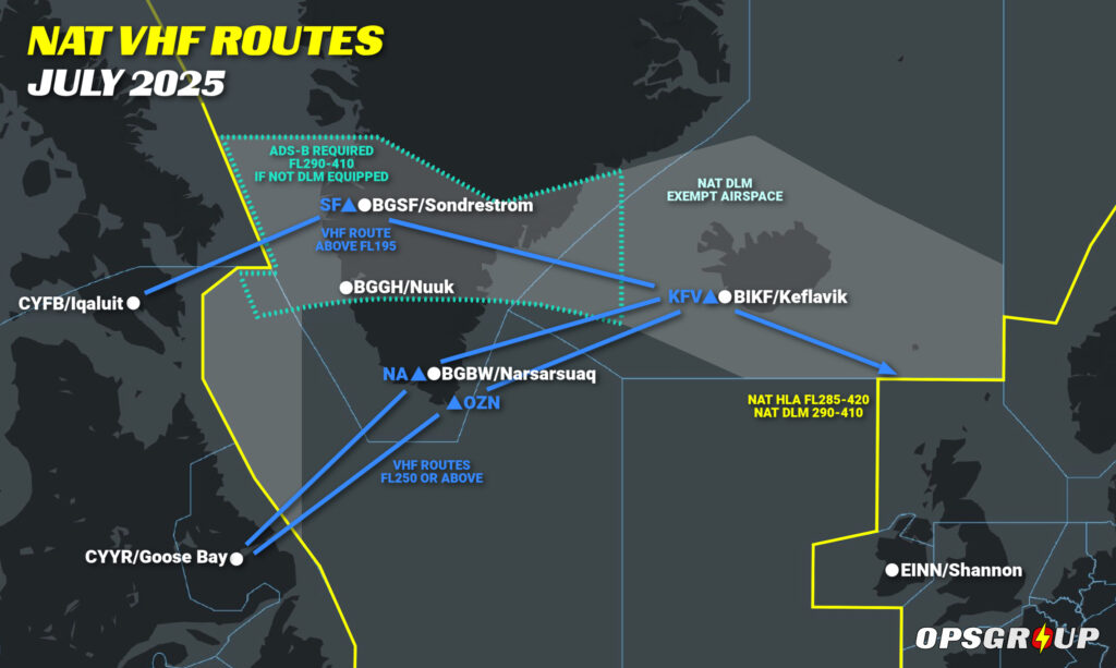
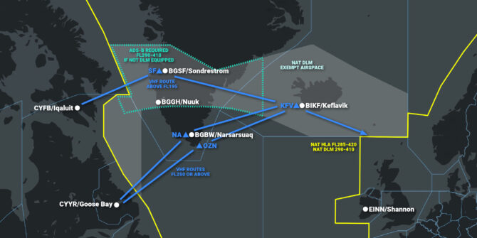
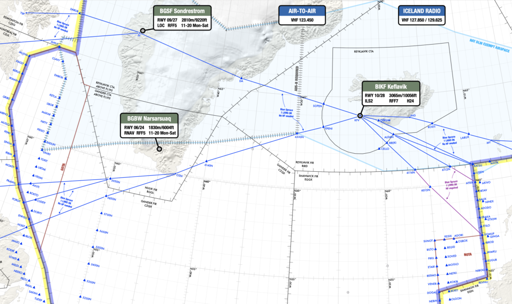
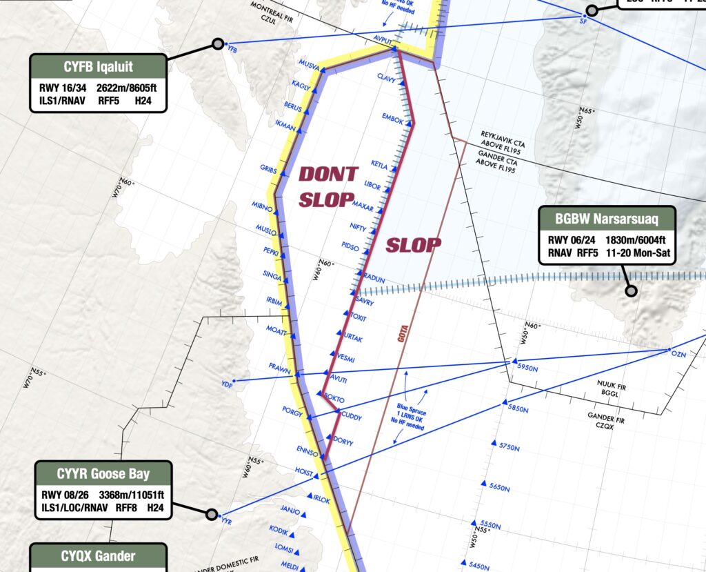
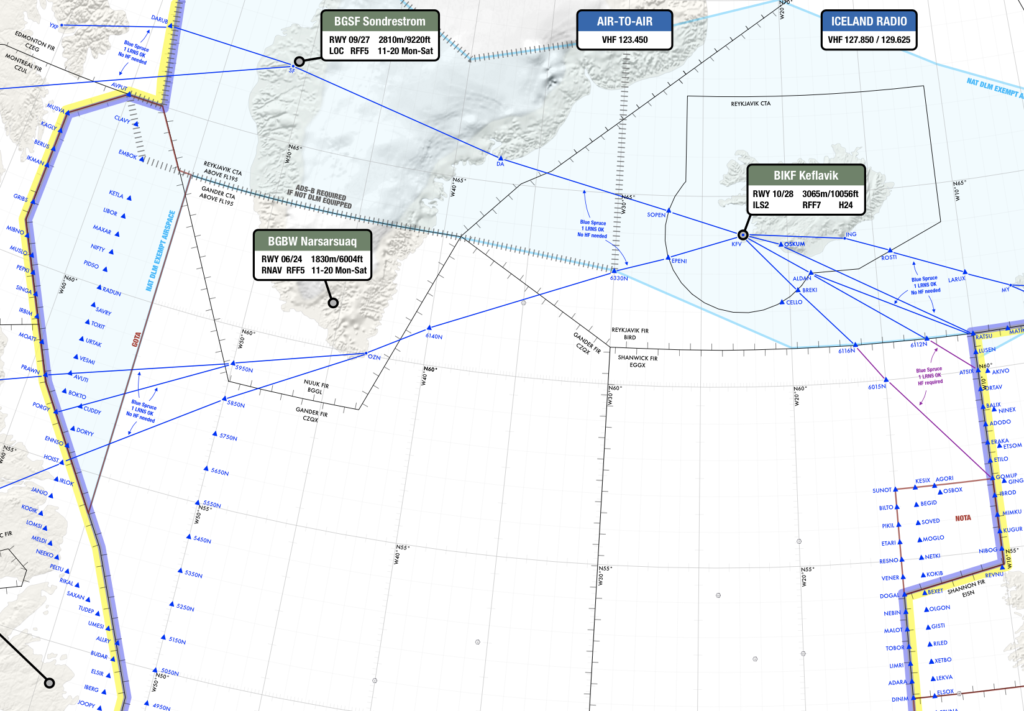
– Above FL195: YFB–SF–KFV
– FL250 and above: YYR–OZN–KFV

Only one LRNS?
➤ Stay below FL285 to avoid HLA nav and datalink rules – but unless you’re on a Gander-approved VHF route (e.g. via OZN or SF), you’ll still need two long-range comms systems.
➤ Want to climb into HLA airspace? You’ll need VHF coverage, ATS surveillance, State approval, and a compliant routing like the Iceland-Greenland corridor.


The Longer Story

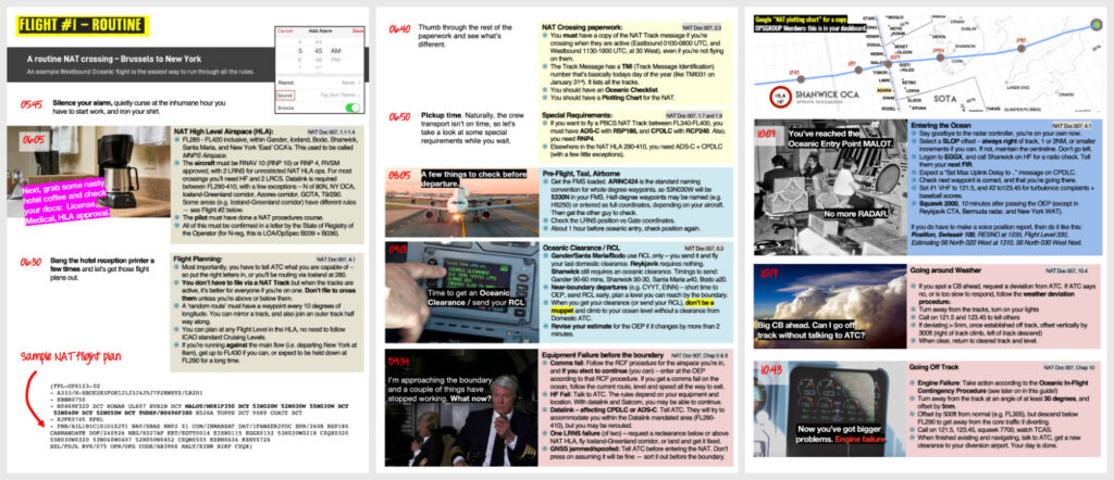
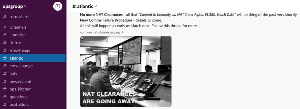
As of March 20, 2025, the Blue Spruce Routes have been officially removed from the North Atlantic. These routes—once the lifeline for aircraft with limited navigation or communication capability—are now a thing of the past. The change is part of the latest update to NAT Doc 007, which you can read more about here.

Technically established in 1976, the Blue Spruce Routes allowed aircraft with only one Long Range Navigation System (LRNS) to transit the NAT High Level Airspace (HLA) under special routing and coverage provisions. Over time, however, the need for them faded. The reasons:

  • Almost no aircraft that have the mandated CPDLC equipment have only one LRNS. Or put another way, if you have CPDLC, you have dual LRNSs unless broken. With the addition of CPDLC requirement, relief for a single LRNS became outdated.
  • Ground-based nav aids along the routes have largely disappeared.
  • Datalink Mandated Airspace now covers most of NAT HLA.
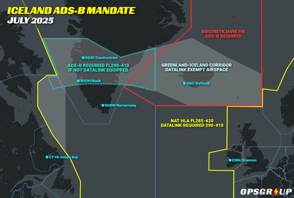
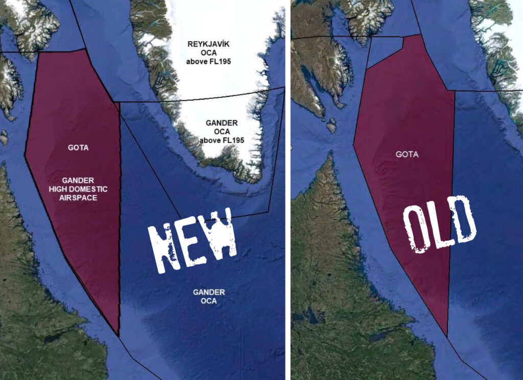
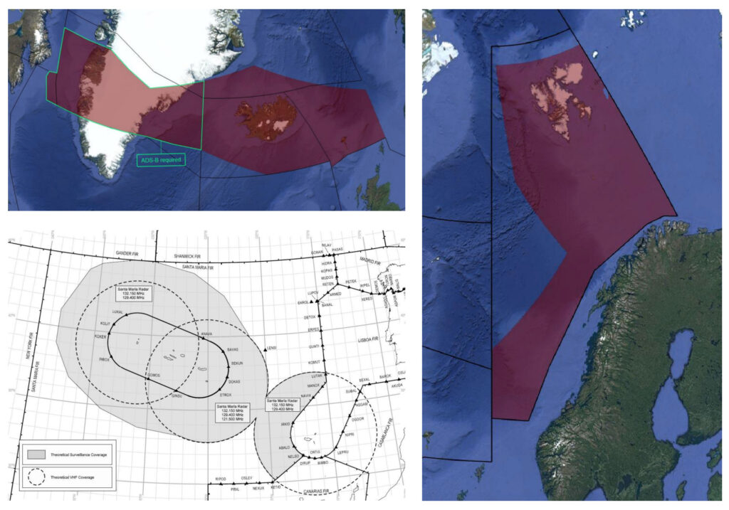
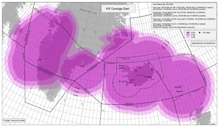
  • The Iceland–Greenland Corridor, with reliable VHF and ATS surveillance, provides a more flexible and better-supported fallback option.

While the Blue Spruce name may still pop up informally (especially among ferry operators), it no longer refers to any officially recognized ICAO routes. But crucially, some of the old routings remain usable—just under new conditions.

For example, Canada now allows aircraft operating with only VHF to cross via specific routes:

  • Above FL195 via YFB–SF–KFV (this one currently says “below” FL195 in the Canada AIP, but that’s been confirmed as a typo, and will be getting updated shortly!)
  • FL250 or above via YYR–OZN (or NA)–KFV

These are the only routes where VHF coverage is considered sufficient for oceanic ops without HF radios. Everywhere else, HF is still required outside VHF range.

So while the Blue Spruce Routes are gone in name and publication, practical exemptions remain—especially for aircraft with partial equipage. What’s changed is how you plan and justify the crossing.

Let’s walk through what you can still do today, based on what your aircraft has (or doesn’t).

Standard Ops

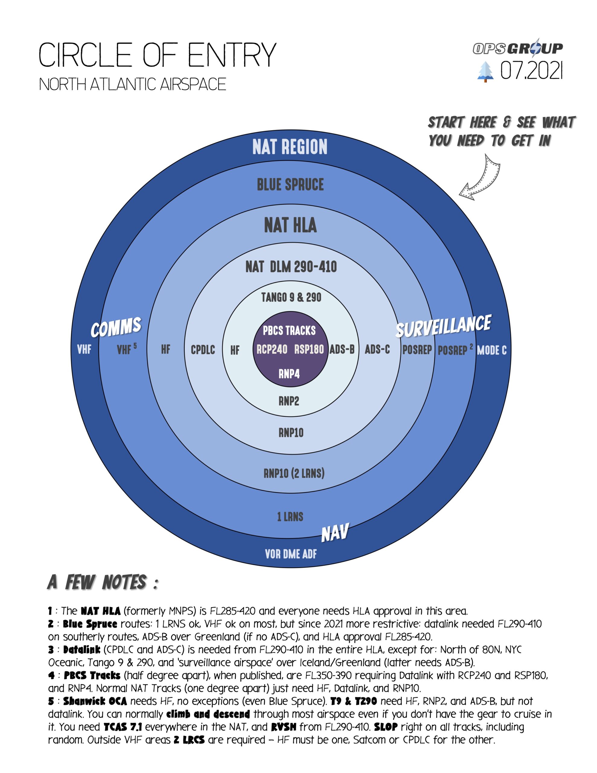
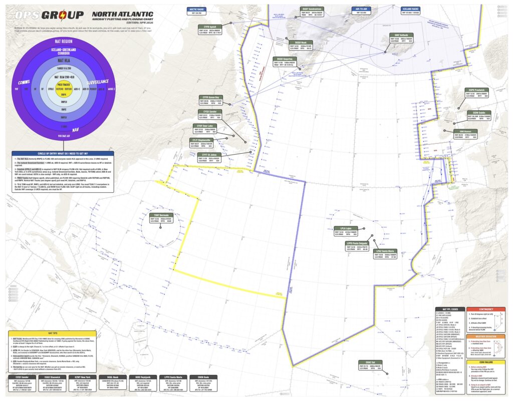
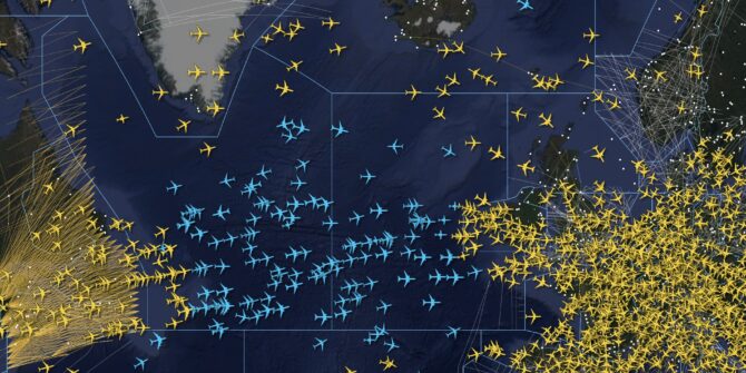
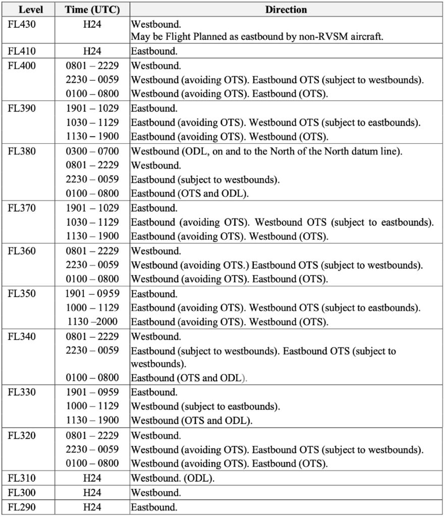
Most traffic crossing the North Atlantic Airspace (NAT) occurs from FL290-410 through the North Atlantic High Level Airspace (NAT HLA). Over the years, advances in navigation, communication, and surveillance equipment have led to additional requirements for operators so ATC can safely reduce aircraft spacing and pack more aircraft through the airspace.

For unrestricted access to the NAT HLA, operators need:

  • 2 Long Range Navigation Systems (LRNSs)
  • Outside VHF areas 2 LRCS are required – either 2x HF, or HF & Satcom/or CPDLC, for the other.
  • FANS 1/A equipment for the NAT Datalink Mandated airspace
  • Super-duper datalink for the coveted PBCS Tracks (i.e. CPDLC capable of RCP240 + ADS-C capable of RSP180)

And for US operators, that equipment list is a prerequisite for several required LOAs:

  • A056 CPDLC Enroute, and Oceanic and Remote (PBCS)
  • B036 Oceanic and Remote Continental Navigation Using Multiple Long-Range Navigation Systems (M-LRNS), Aka. RNP 4 (and RNP 10)
  • B039 NAT HLA
  • B046 RVSM
  • D195 MEL (not technically required for a crossing, but might as well throw this one in)

The above is the ideal setup. But what if I fly old stuff, or new stuff, or broken stuff, or little stuff?

Old Stuff

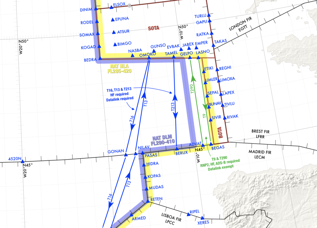
To the formerly early adopters without the benefit of factory standard state-of-the-art equipment: let’s say your aircraft has LRNSs that are only capable of RNP 10, or your FANS equipment is RCP400 and RSP400. All else being equal, the only limitation would be no PBCS tracks. And no T9/T290 either. All other tracks or random routes through the HLA are approved.

Is your equipment so old it doesn’t even have the above equipment? Consider yourself the same as broken, and keep reading…

New Stuff

You just closed on a shiny, new, well-equipped jet and have to ferry it across the pond, but you have no LOAs. In this case, you are altitude and route are limited. No RVSM or NAT HLA LOAs means the airspace from FL290-410 is off limits for you. If traffic permits, ATC may let you climb through the HLA above FL410, but you might want to plan fuel and route at FL280. Route-wise, without B036, you’re flying the Iceland-Greenland Corridor.

If you only have some of the above-listed LOAs, also consider yourself broken.

Now, it gets a little more nuanced…
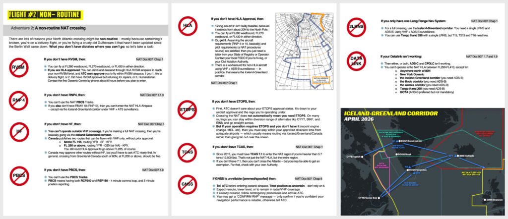
Broken Stuff

You’ve been spoofed, but only one GPS came back? When down to one LRNS (or you don’t have B036), fly the Iceland-Greenland Corridor. With only one LRNS, you could fly through the NAT HLA along the corridor with approval if you stay within surveillance and VHF coverage and have the equipment to fly the assigned route. Otherwise, fly above or below the NAT HLA.

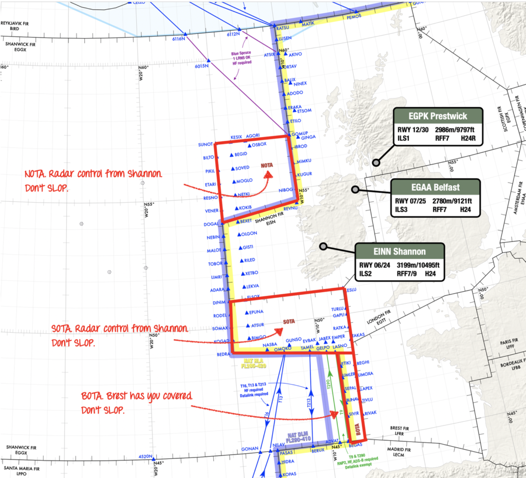
You’re down to one HF or lost both? You can still cross via the Iceland–Greenland Corridor or the old southern Blue Spruce routing via OZN – but only between FL250-280, where VHF coverage is sufficient and you’re still below DLM airspace. Just make sure to stay clear of Shanwick OCA, which still requires HF.

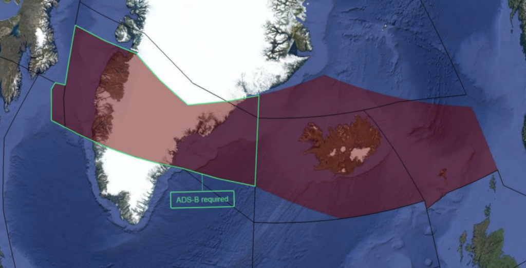
HFs are back, but your Datalink konks out (CPDLC or ADS-C), or you don’t have A056. There are two options: stay within the Data Link Mandate (DLM) exemption area (the corridor) and fly any altitude. The DLM exemption area exists because you don’t need CPDLC in that area if you have ADS-B. Radio reception is pretty good throughout there! The second option is to fly above or below the NAT HLA.
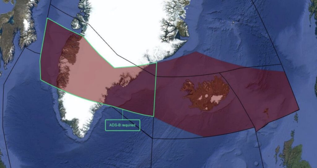
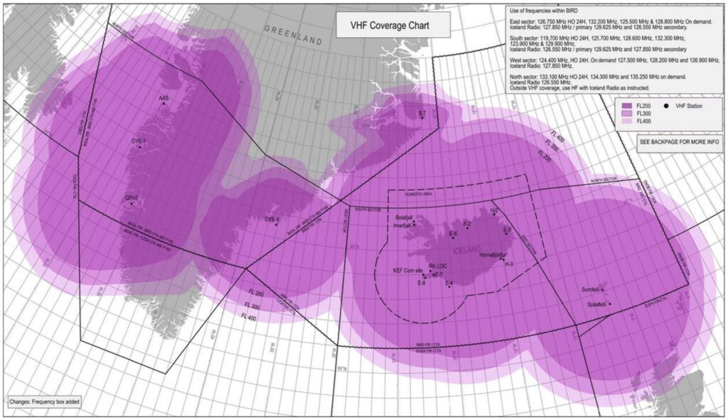
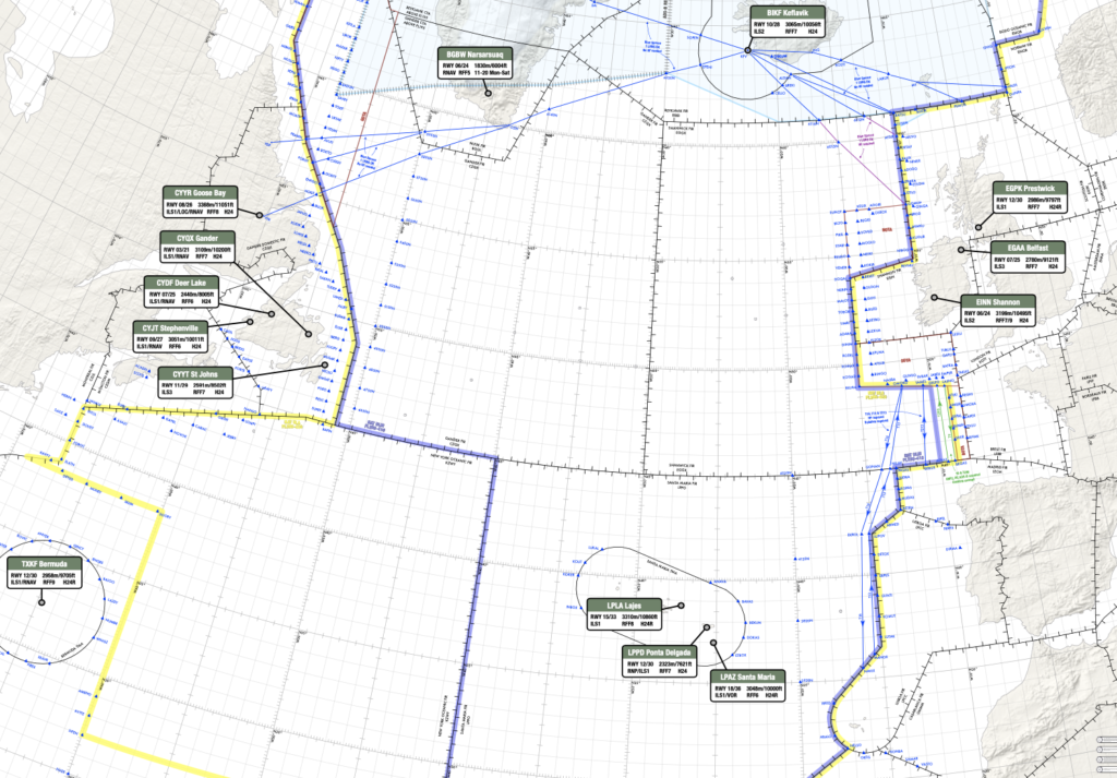
Little Stuff

And if you get a wild hair to cross the Atlantic in an aircraft with only one LRNS, no HF radios, no Datalink, no LOAs, without the range to fly non-stop (like me), you still have options. You’ll need to stick to the Iceland–Greenland Corridor, or the specific VHF-approved routes via OZN or SF.

What’s a Blue Spruce?

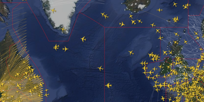
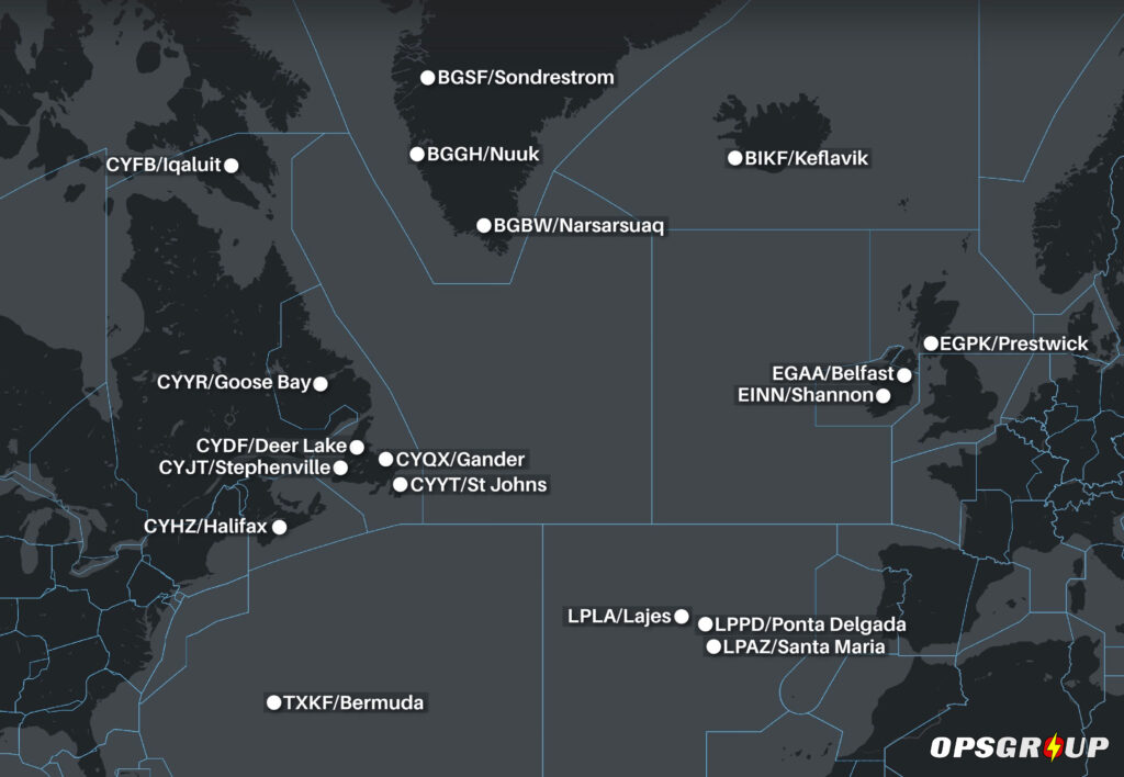
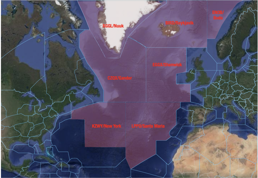
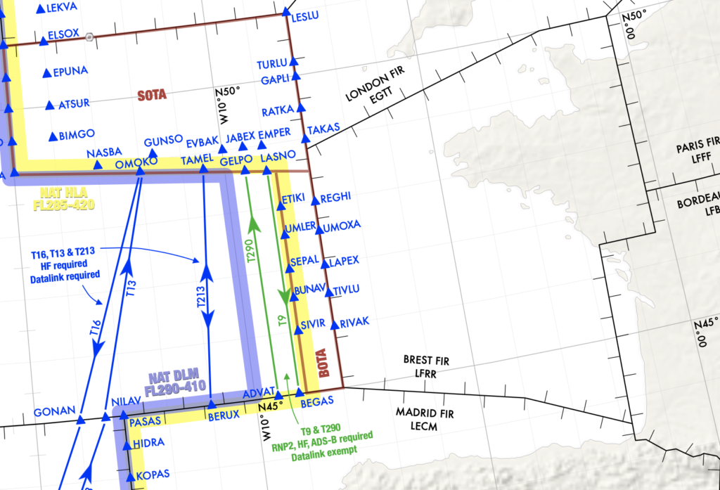
It’s a Christmas tree native to the Rocky Mountains that you won’t see across the Atlantic on any of your stops. However, the Blue Spruce Routes are routes in and around the Atlantic connecting Canada, Greenland, Iceland, and the UK.

Why were they called the Blue Spruce Routes? Back when military aircraft had wooden propellers (sometimes made of spruce), they painted the tips blue. These aircraft had to make the trans-Atlantic journey along the now-known Blue Spruce Routes.
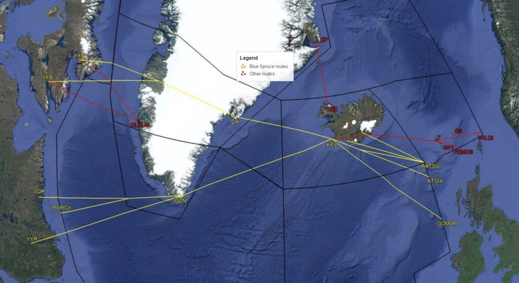
Gray Areas

The Iceland-Greenland Corridor provides exemptions from equipment and operational requirements because land-based radio transmitters along the route provide decent coverage, and route legs are short enough to complete a crossing without necessitating equipment redundancy.

Now, there are exemptions from the rules, and then there are gray areas. Despite all the relief these routes provide, one regulation remains: you must maintain two-way radio communication with ATC.

So far, much of the discussion is how high you can go, but what about how low?

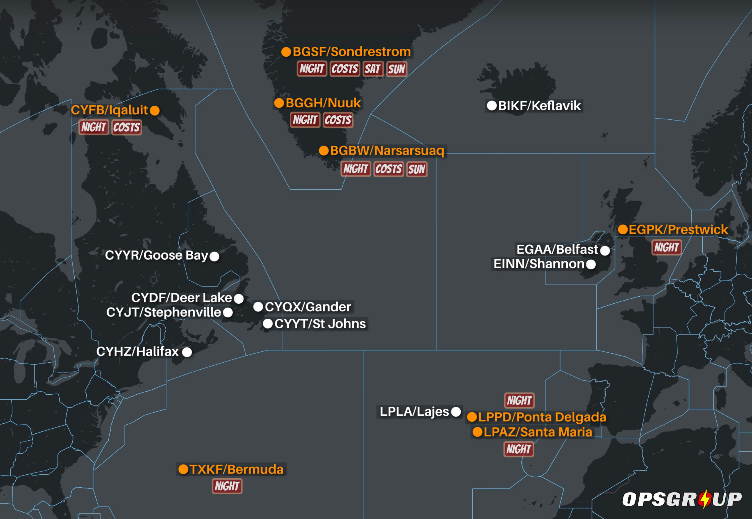
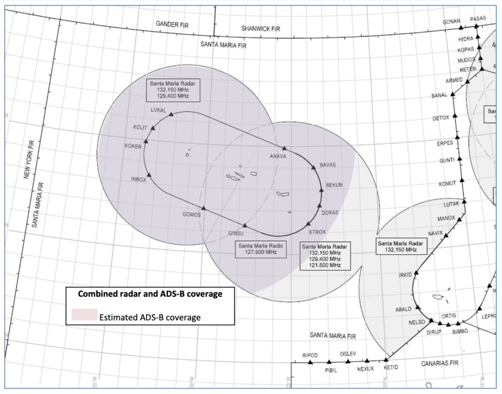
VHF communications have improved significantly in the Atlantic in the last ten years. Both the northern and southern routes have VHF reception at appropriate altitudes. The longest stretch of water is between Canada and Greenland. On the southern route over this stretch of water, I have experienced adequate communication at FL250 and up. The northern route is good down to FL200. Iceland is fantastic – it’s almost like you’re in domestic airspace.

The gray area is when you plan to operate below these altitudes and are counting on using another aircraft to relay position reports. By the letter, this is a no-no. The up-and-up solutions would be to rent a portable HF unit or containerize and ship the aircraft to Europe, both of which can be about $20k.

You can see the incentive to count on relays.

Are ferry pilots bending the rules? Let us descend, inception-style, one further layer down the list of the exceptions: ATC can waive the HF requirement for ferry, delivery, and special event flights. Ferry pilots have all the fun. 😊

What About Aircraft with Only One LRNS?

Back in the day, the Blue Spruce Routes were the go-to option for aircraft with only one Long Range Navigation System (LRNS) crossing the Atlantic. Now that those routes are gone, what are your options?

If you’re staying below the NAT HLA (below FL285), you’re in the clear:

  • You don’t need two LRNSs to operate below FL285.
  • You’re also free from NAT HLA requirements like RNP 10 and Datalink etc.
  • Just make sure your one LRNS (typically GPS-based) is suitable for the route you’re flying.
  • You still need two long-range communication systems (HF + HF or HF + Satcom), unless you’re on one of the VHF-only routes approved by Gander that we talked about above (ie. via OZN or SF)

If you want to enter the NAT HLA (FL285–420), it gets more tricky:

You’ll need to qualify under the NAT Doc 007 1.4.1 exception, which says aircraft can operate in the NAT HLA with fewer than the standard requirements only if:

  • You stay within ATS surveillance,
  • You remain within VHF communication coverage,
  • Your navigation system is suitable for the planned route,
  • And you have specific State approval to operate with reduced navigation capability.

In practical terms, this means you might be able to fly the Iceland–Greenland Corridor at HLA altitudes, but only if your authority signs off – and probably not straight across via the likes of OZN.

Summing up

You can operate with one LRNS, no HF radios, no CPDLC, and no LOAs using the Iceland–Greenland Corridor or the designated VHF routes published by Canada. 

Outside of these specific altitudes and routings, aircraft operating in the NAT Region must normally carry two long-range communication systems, one of which must be HF, when operating beyond VHF coverage – unless a specific exemption has been granted by the State of the Operator or Registry (eg. for ferry or delivery flights).

If you want to learn more, check out myaircraftmanagement.com for a 101-level walkthrough of a Blue Spruce operation.

Happy Crossings! ✈️ 🌊 🧑‍✈️


Updated FAA Oceanic Guides

The FAA has updated its resource guides for the three big oceanic areas of interest: the North Atlantic, the Pacific, and WAT airspace (West Atlantic / Gulf Of Mexico / Caribbean). All three have been updated effective July 2025.

These guides are a good starting point for understanding all the essentials of operating in these regions, and include links to all kinds of useful supplemental information around the main topics for each one.

Click on the pics to check them out.

North Atlantic

Pacific

WAT


To see a timeline of the big changes on the NAT stretching back to 2015 click here.

Opsgroup members can download several NAT guides and a NAT Plotting & Planning Chart via the Members Dashboard here.


NAT Airspace Closures: Formidable Shield 2025

Remember that big NAT military exercise a couple of years ago? Formidable Shield is happening again now, which will mean parts of North Atlantic airspace will be closed to flights for several hours at a time.

There are daily closures in the EGD701 area off the coast of Scotland until May 23, but the big one to watch out for is a large closure of airspace across the northern half of the EGGX/Shanwick FIR on May 20 between 15-21z (with May 22 as the backup day).

The map below shows everything we know about this so far, taken from this UK SUP.

For the big closure on May 20, ATC might start rerouting flights before the airspace closure starts (15z) with the use of Flight Plan Buffer Zones extending 30 NM or 60 NM beyond the closed airspace.

There’s no timings yet for when these might be activated, and ATC have said they won’t make any decision on this until nearer the time when they know where the jet stream is going to be and what the tracks might look like, but best advice would be plan a flight that clears the area at least 1 hour before the airspace closure (so 14z).

Keep an eye on the EGGX/Shanwick Notams – they will publish one for the big closure at least 24 hours prior, which will look a bit like this (except it will say EGD2FS25 instead of EGD1FS25).

And for any questions on Formidable Shield, you can contact the UK Airspace Management Cell at SWK-MAMC-ManagedAirspace@mod.gov.uk.


NAT Changes 2025: No More Blue Spruce Routes

Key Points: Updated 19 March 2025
  • A new NAT Doc 007 takes effect from 20 March 2025.
  • Blue Spruce Routes are being removed. Aircraft with only 1 x LRNS will have to go via GOTA and the Iceland-Greenland corridor instead.
  • There are new super fun chapters on Space Weather Contingencies and GNSS Interference Events.
  • Other NAT news: Shanwick does not expect to implement the removal of Oceanic Clearances before summer 2025.
  • Other NAT news: There’s a big military exercise coming in May which will close large parts of the Shanwick FIR.
  • Other NAT news: Greenland airport BGGH/Nuuk now more viable NAT alternate with a brand new runway (7200’/2200m) opened in Nov 2024.

Once (or sometimes twice) every year, ICAO update their NAT Doc 007 – the main guidance doc for ops over the North Atlantic. All the specifics about how to operate your aircraft safely through the complex airspace of the region are here.

There’s a new one that takes effect from 20 March 2025, which contains a few important changes to know about if you’re planning a flight across the NAT.

You can download the new NAT Doc 007 in full, but here’s a summary of the main changes…

Deletion of Blue Spruce Routes

If you’re new to the NAT, the Blue Spruce Routes have been around since forever. These are special routes that go via Greenland and Iceland, designed to help aircraft with limited navigation capabilities.

The Blue Spruce Routes will be officially deleted in March 2025. The team behind this (the Blue Spruce Routes Project Team) has decided the following:

  • There aren’t enough ground-based navigation aids anymore to reliably support these routes.
  • Hardly anyone uses them, as very few aircraft with single LRNS rely on them.
  • The Iceland-Greenland surveillance corridor is a good enough alternative for aircraft with navigation issues.
  • The difference in flight distance between Blue Spruce Routes and alternative corridors is so small it’s not worth keeping them.

So from March 20, the Iceland-Greenland corridor will replace Blue Spruce Routes as the backup option. A review is also underway to decide whether to keep or remove remaining ground-based navigation aids.

Updated NAT Doc 007

Here’s some of the other stuff in the newly updated version of this, effective 20 March 2025:

Deleted sections, New sections, and Chapter Switcheroos

Deleted sections:

  • Chapter 12 on Guarding Against Common Errors
  • Chapter 13 on The Prevention Of Lateral Deviations From Track

New sections:

  • Chapter 10 on Special Procedures For In-Flight Contingencies now includes a section to help crews handle space weather contingencies (explains how to manage impacts on communications, navigation, and surveillance systems caused by solar activity) and GNSS interference events (guidance on what to do in case of GPS jamming or spoofing, based on lessons from recent incidents).

Chapter Switcheroos:

Not that interesting. Same content just in different places now. Over to ChatGPT for a summary of this one:

  • Monitoring of Aircraft Systems & Flight Crew Performance moved to the end of the document and renumbered as Chapter 13.
  • Navigation System Failure Procedures is now Chapter 9 (was Chapter 10).
  • In-Flight Contingencies Procedures is now Chapter 10 (was Chapter 11) and includes the new space weather and GNSS interference guidance.
  • Dispatchers’ Guidance is now Chapter 11 (was Chapter 14).
  • Flight Operations Below NAT HLA is now Chapter 12 (was Chapter 15).

GOTA

The picture of the airspace boundaries for GOTA has been corrected slightly from the previous NAT Doc. (The GOTA boundaries haven’t changed, they just had the wrong pic in before!)

RCL timings & Squawking 2000

A couple of minor updates here:

  • In the Reykjavik OCA, you must now send your RCL no earlier than 15 minutes prior to the OEP (it used to be 20 minutes).
  • They’ve also updated the bit about squawking 2000 10 minutes after passing the OEP – you should do this everywhere except the Reykjavik CTA and when transitioning through Bermuda radar (it didn’t mention Bermuda before). Squawking 2000 is not required in these areas as they have you on radar!

Continued confusion about the Removal of Oceanic Clearances

The new version of the NAT Doc 007 tries to consolidate all the changes made after the March 2024 roll-out of OCR procedures. The only problem is that it now says that “No oceanic clearance is required” without pointing out that this doesn’t yet apply to Shanwick! 

Everything about the Removal of Oceanic Clearances so far has been quite confusing for crews. What is happening, when it’s happening, what is changing, the constant implementation date changes, plus the fact that there has been a bunch of confusing documentation out there with incorrect dates and procedures that are not yet in place.

So here’s the lowdown!

  • Reykjavik and Santa Maria = removed Oceanic Clearances in March 2024
  • Gander and Bodo = removed Oceanic Clearances in Dec 2024.
  • Shanwick = still has Oceanic Clearances!

So, Shanwick is the only NAT ANSP still to make the change – and the main news at the moment is that Shanwick does not expect to implement the removal of Oceanic Clearances before summer 2025.

Until then, westbound flights entering Shanwick from domestic airspace will continue to be the only flights on the NAT that will still require an Oceanic Clearance. For more info on all this, OPSGROUP members should check this post in their Dashboard.

Other important NAT stuff to look forward to

Formidable Shield military exercise expected in May 2025

Remember that big NAT military exercise a couple of years ago? Formidable Shield is happening again soon, and this year will be a fairly bad vintage. 

There will be daily closures in the D701 area off the coast of Scotland from May 5-23, but the big one to watch out for is a large closure of airspace across the northern half of the EGGX/Shanwick FIR on May 20 between 15-21z (with May 22 as the backup day).

The map below shows everything we know about this. For more info, check this UK SUP.

Changes to Greenland NAT alternates

BGGH/Nuuk airport’s brand new runway (7200’/2200m) opened in Nov 2024, with ILS at both ends, which on the face of it makes Nuuk a more viable diversion option for NAT traffic.

But since it opened, we’ve had reports of a few things to watch out for at BGGH/Nuuk:

  • ATC may delay your arrival and put you into a hold as only one ILS approach can be handled at a time, and 15 min separation is being applied between international arrivals. So carry up to half an hour of extra fuel if possible.
  • In practical terms the airport is effectively closed overnight. Because it’s a brand new airport, night opening is unrealistic at the moment – especially in winter. In the summer months, when there’s no snow and it’s daylight almost all day every day, there won’t be the same need for runway sweeping and using the airport as a diversion alternate might be more possible.
  • Aircraft larger than A330 should consider continuing using BGSF/Sondrestrom as an alternate instead – it may make more sense to divert here with the longer runway and less traffic compared to the marginal runway in BGGH/Nuuk.

Also watch out for changes potentially coming at BGSF/Sondrestrom, where they’re considering downgrading ATC to AFIS at the end of 2025. More info here.

Did we miss anything?

If you spotted anything important in the new NAT Doc 007 which we missed in this summary, please let us know! Email us at news@ops.group

More help with North Atlantic ops


FIRE on the NAT! Where to go in an emergency?

In OPSGROUP, we talk a lot about the North Atlantic. Whether it’s a Plotting Chart you need, or an explanation of the Datalink Mandate, or a summary of big changes stretching back to the dawn of time – we’ve got you covered. We love the NAT so much we even enjoy asking ourselves annoying questions about it over and over again to see if we can answer them (we can).

But here’s something we haven’t fully looked into before – if you’re in big trouble on the NAT (like an engine on fire, for example), where can you go? 

Turns out there’s quite a bit of complexity to this. Some airports don’t have amazing levels of fire cover, some are closed at night, and some have weird setups where you have to pay them in advance to make sure they stay open in case you need them.

We’ll start with these odd ones. And we’re going to do everything in local time to keep things easy. Also, for the uninitiated, RFFS means Rescue and Fire Fighting Services (i.e. what level of fire cover an airport has), and if you’re confused about what number means what, you can read all about it here.

Odd Ones

CYFB/Iqaluit

  • Airport open: Mon-Fri 08-17, other times 12hrs notice required
  • RFFS: 5
  • Why odd? So it’s basically closed at night unless you make a special request for them to stay open in case you need them. If extended hours are needed, additional costs will apply to keep staff on standby. Requests to extend operating hours at the airport must be submitted using a specific document for either RFF5 or RFF7. CYFB provides extra RFF coverage at night on average 40 to 50 times a month. The cost for them to stay open with RFF5 is $1714 which gives you a 4 hour block of time. For RFF7 it’s $3427.

BGGH/Nuuk

  • Airport open: 06-21 every day
  • RFFS: 5 (or RFFS 8 with 4 hours notice)
  • Why odd? Technically it’s open at night, but as it’s a brand new airport, night opening is unrealistic at the moment – especially in winter. In the summer months, when there’s no snow and it’s daylight almost all day every day, there won’t be the same need for runway sweeping and using the airport as a diversion alternate might be more possible because they will only require standby personnel on short notice.

BGBW/Narsarsuaq

  • Airport open: Mon-Sat 08-17 (yep, closed on Sundays!)
  • RFFS: 7
  • Why odd? Can be requested to stay open at night most of the time. But watch out! As we reported before, Greenland airports will charge you the better part of $3k if you list either of them on your flight plan as diversion alternates when they’re closed.

BGSF/Sondrestrom

  • Airport open: Mon-Fri 08-16 (yep, recent change here is that they’re closed on weekends!)
  • RFFS: 5 (or RFFS 8 with 4 hours notice)
  • Why odd? Same as BGBW, can be requested to stay open at nights or on weekends, but same costs will apply.

EGPK/Prestwick

  • Airport open: H24
  • RFFS: 7
  • Why odd? Often at night they close the terminals building (they always Notam it) so there are no facilities for diversions at these times.

LPPD/Ponta Delgada

  • Airport open: 0615-0000
  • RFFS: 7 (can be increased to RFFS 9 with 24hrs notice at a cost of 70 Euros per hour, although they say this can usually be increased for emergencies too).
  • Why odd? At night (0000-0615), the airport has told us that they are closed and will only guarantee reopening for urgent medical evacuation flights, or humanitarian flights at the request of the Portuguese Air Force. LPLA/Lajes is the only airport in the Azores that is open all night for diverts.

LPAZ/Santa Maria

  • Airport open: It’s complicated.
  • RFFS: It’s complicated.
  • Why odd? Ok, here we go. So from 0635-2130 they are fully open with RFFS 6 (RFFS 8 available for a surcharge if you arrange in advance). Then from 2130-0000 the airport is closed but you can request they stay open for around 900 Euros (plus a fee to the handling agent). Then from 0000-0645 the airport is completely closed and cannot accept emergency diverts at all. Bottom line, just go to LPLA/Lajes instead.

TXKF/Bermuda

  • Airport open: 07-23 every day
  • RFFS: 9
  • Why odd? To get them to open at night (ATC and RFFS) for emergencies, you need to give them 30 mins notice – so not ideal if your needs are super urgent. Also, they do sometimes publish Notams saying that ATC will not be available for certain periods at night, even for emergencies.
Not Odd Ones

Ok great! Here are all the straightforward airports that are open H24 with decent fire cover:

CYYR/Goose Bay
Open H24
RFF 5 (RFF 8 on request)

CYQX/Gander
Open H24
RFF 5 (RFF 6/7/8 with 2hrs notice)

CYDF/Deer Lake
Open H24
RFF 6 (RFF 7 with 30 mins notice)

CYJT/Stephenville
Open H24
RFF 5 (RFF 6 with 30 mins notice)
In winter months, they often have a Notam saying that they might need 2hrs notice at night to clear the runway of snow.

CYYT/St Johns
Open H24
RFF 7

CYHZ/Halifax
Open H24
RFF 7

BIKF/Keflavik
Open H24
RFF 8 daytime 05-19 (RFF 7 overnight 19-05)

EGAA/Belfast
Open H24
RFF 7 (RFF 8/9 with 24hrs notice)

EINN/Shannon
Open H24
RFF 9 (may on occasion be reduced to RFF 7 depending on staffing)

LPLA/Lajes
Airport open 07-21 (but H24 for emergencies)
RFF 8 at all times

So let’s give that map another try, this time with a tasteful splash of orange colour…

So there you have it, friend! While we’re on the subject of Emergency Diverts, you might also be interested to read about NAT Contingency Procedures (what to do when you need to deviate from your ATC clearance due to an emergency). For more info about recent changes to Greenland Airports, click here. And to download the latest OPSGROUP NAT/North Atlantic Plotting and Planning Chart 2025, head over here.

As usual, any questions, let us know at team@ops.group.


2025 North Atlantic Plotting & Planning Chart

The new OPSGROUP NAT/North Atlantic Plotting and Planning Chart 2025 is released today! This is our chart showing North Atlantic Oceanic Airspace and adjoining domestic airspace, with easy to read NAT Tips, Airspace Requirements, Emergency Procedures, and much more!

OPSGROUP members – you can grab a copy in your Dashboard. View it on your iPad or Laptop etc. as a PDF, or print it out! If you’re not a member, read on for how to get a copy…

Changes in this NEW edition (Oct 2024):

  • FULLY UDPATED for 2025!
  • UPDATED! NAT Tips – using NAT Tracks, SLOP, filing an Oceanic Flight Plan, and helpful tips.
  • UPDATED! Quick reference for contingency, weather, and comms failure with easy graphics.
  • UPDATED!: NAT Airspace Circle of Entry 2025 – easily check what you need for Nav, Comms and ATC Surveillance depending on which bit of the NAT you will be flying through.
  • Additional diversion airports, now 16 total primary NAT alternates with runway, approach, length, RFF, and hours.
  • Easy view of boundaries for HLA and DLM/Datalink mandated airspace.
  • Updated NAT FPL codes, clearance frequencies, Satcom, and HF.
  • Fully updated “South East Corner” with new Tango routes.
  • and … Treasure Boxes!

Other chart features:

  • Requirements for NAT tracks, PBCS tracks, datalink mandate.
  • Common NAT Diversion Airports.
  • Runway Orientation, Length, best IFR Approach.
  • RFF Category and Opening hours.
  • NAT FPL Codes and sample FPL.
  • Blue Spruce routes and equipment requirements.
  • All NAT Entry/Exit points with associated required landfall fixes.

There are two options to download a copy of the NAT Chart:

OPSGROUP Members

You can get it in your Dashboard, under Briefings and Guides.

Get it from the OPSGROUP Store

Not a member? Get a copy from the OPSGROUP Store.


NAT Conundrums: Volume I

Originally published 2021, Updated 2024

It’s no surprise to most that the North Atlantic is the busiest oceanic airspace in the world. To keep things running smoothly there are a bunch of procedures to follow. We write about them a lot, especially when they change. From time to time questions continue to pop up that make us scratch our heads. And so we thought this might be a good chance to share a few of those with you – naughty NAT conundrums if you will.

To SLOP or not to SLOP?

Chances are if you fly in oceanic airspace you already heard of Strategic Lateral Offset Procedures (SLOP). They’re pretty straightforward – you’re supposed to offset up to 2nm right of track without needing a clearance.

We do this because humans are fallible and mistakes can be made. Ironically the extreme accuracy of modern navigation systems mean that in the case of gross navigational errors, level busts or incorrect clearances, these systems actually increase the chance of a collision. So we pull over to the side of the road a little more, just in case.

Do we have to SLOP?

If you’re in the NAT HLA and your aircraft is capable then yes, it’s ‘required’ (as per ICAO NAT Doc 007). The only time you shouldn’t is if your aircraft’s FMS cannot automatically maintain an offset i.e. it doesn’t have that function. In that case you ‘must’ stay straight up the middle.

Remember, your SLOP can be in increments of 0.1nm and “0 nm” SLOP is also a thing!

You SLOP from the ENTRY point only, and need to have stopped the SLOP by the EXIT point.

  • Don’t go ‘direct to’ the EXIT, this will put you on a different track. Cancel the SLOP to return to ‘centreline’
  • Only SLOP from the ENTRY to the EXIT
  • If you are routing from a NAR into the NAT, the last point is your entry into the NAT and you can SLOP from here

Can we SLOP in the Oceanic Transition Areas?

Or in other words in NOTA, SOTA, BOTA or GOTA? Good question.

NOTA and SOTA: The short answer is no. The slightly longer one is that the both NOTA and SOTA are under radar control with domestic separation from Shannon Radar. You should only apply SLOP between your oceanic entry and exit points.

BOTA: It’s a similar story. BOTA radar control services are provided by Brest Control in France – essentially domestic rules still apply. So no SLOP-age.

GOTA: This is the odd one out. GOTA (the Gander Oceanic Transition Area) is off the coast of North-eastern Canada. You should SLOP only once you have passed the Oceanic Entry Point (OEP) eastbound and within Oceanic Airspace “proper”, and vice versa westbound – sto SLOP at the Oceanic Exit Point (for example NIFTY on the chart below).

Are there any other ‘gotchas’?

Yes – three main ones:

  1. The ENOB/Bodo and BIRD/Reykjavik FIRs. Look out for these. Buried in the NAT Doc 007 it says that you are only allowed to SLOP above FL285. So don’t get caught out in the lower levels.
  2. Tango Routes T9 and T290. These lie just outside of BOTA airspace. According to the UK AIP ENR 3.5, SLOP does not apply here.
  3. And whatever you do – never SLOP left!

What’s the difference between the NAT Region and the NAT HLA?

The NAT Region is virtually all of the non-domestic airspace over the Atlantic – from around 20 degrees north all the way up to the pole (excluding New York Oceanic West). It contains seven Oceanic Control Areas – BGGL/Nuuk, BIRD/Reykjavik, ENOB/Bodo Oceanic, CZQX/Gander, EGGX/Shanwick, KZWY/New York Oceanic East and LPPO/Santa Maria.

Within the NAT region (and occupying a large amount of it) is the NAT HLA, which stands for High Level Airspace. It only exists from FL285 to FL420.

Because the NAT HLA is some of the busiest airspace in the world, there are a number of stringent navigation and communication requirements that you must meet to enter it. This includes being either RNP 4 or RNP 10 capable, having two independent long range navigation systems and in most cases, datalink. Operators also need state approval.

If you don’t meant those requirements you can still fly through the NAT Region, but you’ll have to fly below or above the NAT HLA. Blue Spruce routes are the exception, which allow aircraft with only one long range navigation system or limited comms equipment to enter.

Can I fly across the North Atlantic without Datalink?

Yes, but it’s gonna be tricky.

The North Atlantic Datalink Mandate (NAT DLM) means aircraft need to have CPDLC and ADS-C to operate between FL290-FL410 throughout the NAT Region.

There are a few exceptions where the NAT DLM does not apply:
– Everything north of 80°North.
– New York Oceanic East FIR.
– Tango Routes T9 and T290. The other Tango Routes (T213, T13, T16) all require datalink.
– ATS Surveillance airspace, where surveillance service is provided by means of radar and/or ADS-B, coupled with VHF.

That last one about “ATS Surveillance airspace” is essentially just a section of airspace over Greenland and Iceland, which looks like this:

So if you’re on a NAT crossing and you don’t have datalink, you technically have to stay below FL290 until you hit the blue shaded area. It’s worth noting that aircraft without datalink can request to climb/descend through datalink mandated airspace, but will only be considered on a “tactical basis” by ATC.

Further south, there is another section of “ATS Surveillance Airspace” in the area connecting the LPPC/Lisboa FIR (i.e. mainland Portugal) to Madeira and the Azores, which is also exempt from the NAT DLM:

So in theory, an Atlantic crossing without datalink would also be possible here – within the LPPO/Santa Maria FIR you would just have to ensure that you stay below FL290 or above FL410 outside of the bubbles until you reach the KZWY/New York FIR (where the NAT DLM does not apply).

Even further south, in the TTZP/Piarco and GVSC/Sal FIRs, CPDLC is the primary means of communication, but it’s still not mandatory.

So down south, the bottom line is that as long as you stay out of the LPPO/Santa Maria FIR between FL290-410 where the NAT DLM applies… except for the ATS Surveillance Airspace bubbles where it doesn’t apply… then you’ll be ok with just HF. Got it? 😊

For more info on the NAT Datalink Mandate, check out our previous article.

So, what’s your conundrum?

We’d love to hear it. Chances are if you don’t know the answer, many other people won’t either, so it’s always great to share.

Get in touch with us at team@ops.group with your question, and we’ll include it in the next article on Naughty Nat Conundrums.

And if you want to download a PDF of our North Atlantic Plotting Chart, check how to get a copy here.


NAT Clearance changes – a game! (V4)

  • We’ve made a little game to help with Oceanic Clearances changes on the NAT.
  • You can download it here.
  • Updated June 19, 2024 – Edition 4!

Why the game?

By Christmas of 2024, all OACC’s on the NAT will stop transmitting an Oceanic Clearance to you. They still want you to send an “RCL” message, which used to mean “Request Clearance”, but now it just means “Tell us your latest preferences”. Think of it as Checking In.

There are different dates when Oceanic Clearances will cease to be issued in the following FIRs:

  • Shanwick: April 9  May  Q4 2024  December 4
  • Gander: March  May 3  December 4
  • BodøMarch  May 6 June 17  December 4
  • Santa Maria: completed March 21
  • Iceland:  completed March 21

But let there be no further blather about it here! We’ve done enough of that already – check here for our full post on the topic. Just play the game – it’s fun, and will tell you everything you need to know in 3 pages! Print it out, share it, pin it on a wall somewhere if you so desire. We do so desire.

And if you have a question not covered in the game, send it to us at team@ops.group, and we’ll help you out – and add it into the next version.


NAT Changes 2024: No More Oceanic Clearances

Key Points
  • ICAO have published a new NAT Doc 007, effective from March 2024.
  • Big Change #1: There will be no more Oceanic Clearances on the NAT (now a mess).  
  • Big Change #2: NAT Comms Failure Procedures have been simplified.
  • Big Change #3: Squawking 2000 ten minutes after OEP will be standard everywhere in the NAT. 

Once (or sometimes twice) every year, ICAO update their NAT Doc 007 – the main guidance doc for ops over the North Atlantic. All the specifics about how to operate your aircraft safely through the complex airspace of the region are here!

The new version for March 2024 has just been released!

Where’s the new Doc?

You can find it on the ICAO page here.

Big Change #1: No More Oceanic Clearances

The idea is that with all the fancy tools ATC now have at their disposal (CPDLC, RSP and RCP compliance, and space-based ADS-B), we have reached a point where the Oceanic Clearance is no longer required.

It sounds drastic, but think of it this way: the NAT will now just be the same as the rest of the world – you fly what is loaded in the FMS or as amended by ATC.

ICAO have also published this Bulletin for flight crews on this specific issue of the removal of Oceanic Clearances. This Bulletin has been updated as of 22nd Jan 2024. There are now different dates when Oceanic Clearances will cease to be issued in the following FIRs:

  • ShanwickApril 9  May  Q4 2024  December 4
  • GanderMarch  May 3  December 4
  • BodøMarch  May 6 June 17  December 4
  • Santa Maria: completed March 21
  • Iceland:  completed March 21

NATS (who manage Shanwick airspace) have published a video about this change, which shows exactly how it will work and what you will need to do.

Big Change #2: Simplified Comms Failure Procedures

As per Chapter 5 of the 007 Doc, from March 2024 here’s what you do:

  • Comms failure before entering the NAT: assuming you don’t divert, you enter the NAT via the Oceanic Entry Point at the level and speed resulting from whatever radio comms failure (RCF) procedures you just had to do in adjacent airspace.
  • Comms failure after entering the NAT: maintain the cleared route/level/speed until reaching the Oceanic Exit Point (ideally don’t change route/level/speed unless you have to), then get back to your flight planned route “in the most direct manner possible” no later than the next significant point.
  • Comms failure if operating to an airport in the NAT: follow the standard PANS-ATM procedures. What are these? – head to an airport aid/fix, hold until the ETA as per the flight plan, do a normal instrument approach, land!

Big Change #3: “Last Assigned Code” Procedures Standardized

A bonus one we spotted! We don’t have to wait til April 2024 for this either – it has already happened. Essentially, squawking 2000 ten minutes after OEP is now standard in the NAT.

Since the dawn of time, everywhere on the NAT, this domestic code had to be retained for 30 minutes after entering NAT airspace. But back in July 2023, the UK changed it to 10 minutes for the entire EGGX/Shanwick FIR, and since then, all the other NAT FIRs have updated their rules to say the same – so this new 10-minute rule has now become the standard across the NAT Region. One exception: if you’re in the Reykjavik CTA, don’t do it (they still have you on radar).

Phew, we survived!


Oceanic Errors on the North Atlantic

ICAO have updated their “Oceanic Errors” NAT Ops Bulletin – the doc which has all the advice for operators on how to avoid the common mistakes when flying the North Atlantic.

These include: Gross Nav Errors, Large Height Deviations, and Longitudinal Separation busts. There’s also some advice on Flight Planning, SLOP, and some datalink things to watch out for.

You can download the NAT Ops Bulletin here:

Looks like there are no big changes in terms of content for this updated version when compared with the old one from last year – they’ve improved the language to be more friendly to human ears, and corrected some of the references. But if you operate over the North Atlantic it’s still worth a read, as there’s lots of top tips on how to avoid the most common gotchas!


The North Atlantic Datalink Mandate – 2024 update

A period of temporary relief of the North Atlantic Datalink Mandate (NAT DLM) rules ended in Feb 2021. So since then, aircraft need to be CPDLC and ADS-C equipped to operate between FL290-410 throughout the NAT region.

Exceptions – areas where you DON’T need datalink

– Everything north of 80°North.

– New York Oceanic East FIR.

Tango Routes T9 and T290. The other Tango routes (T213, T13, T16) all require datalink.

– GOTA airspace. We discovered this in Aug 2022, after some lengthy discussions with the authorities.

– ATS Surveillance airspace, where surveillance service is provided by means of radar and/or ADS-B, coupled with VHF. This includes the Azores, Bodo, and Iceland-Greenland corridor.

Tell me more about this “ATS Surveillance airspace”

This is a tricksy one.

NAT Doc 007 sets out the exempted ATS Surveillance airspace over Greenland and Iceland where you can still fly if you don’t have datalink (though if you don’t have it, you must have ADS-B!)

This area is bounded by the following:

Northern boundary: 65N000W – 67N010W – 69N020W – 68N030W – 67N040W – 69N050W – 69N060W – BOPUT.
Southern boundary: GUNPA (61N000W) – 61N007W – 6040N010W – RATSU (61N010W) – 61N020W – 63N030W – 6330N040W – 6330N050W – EMBOK.

Here’s how that looks:

The southerly Blue Spruce routes

These go over Greenland linking Canada with Iceland via waypoint OZN, and are not fully contained in the exempted airspace. So if you’re flying these southerly Blue Spruce routes you will have to meet the NAT DLM requirements or fly outside of the vertical parameters of DLM airspace (i.e. below FL290 or above FL410). In other words: you need CPDLC and ADS-C to fly on the southerly Blue Spruce routes between FL290-410.

The northerly Blue Spruce routes

These are the ones going overhead BGSF/Sondrestrom airport. These do fall within the exempted area of airspaceso datalink is not mandatory if you’re flying here.

Aircraft without datalink can request to climb/descend through datalink mandated airspace, but will only be considered on a “tactical basis” by ATC (i.e. you have to ask them on the day, and they’ll let you know, depending on how busy it is).

Flights that file STS/FFR, HOSP, HUM, MEDEVAC, SAR, or STATE in Field 18 of the FPL, are permitted to flight plan and fly through datalink mandated airspace, but may not get their requested flight levels.

For more details about the datalink mandate, check out the NAT Doc 007 in full here.

So, to recap…

  • Datalink Airspace: Remember, NAT DLM airspace only applies from FL290-410. Below or above that, you don’t need datalink in the North Atlantic.
  • If you have full datalink (CPDLC and ADS-C): You can go where you like. But watch out here – “full datalink” means you have Inmarsat or Iridium. HF datalink alone (ACARS) does not meet the satcom part of the NAT DLM requirement. So if you want to fly in NAT DLM airspace (FL290-410 in the NAT region) “J2” in field 10a of your FPL isn’t enough – you need “J5” for Inmarsat or “J7” for Iridium.
  • For GOTA airspace: You need a transponder, automatic pressure-altitude reporting equipment and VHF. If you have ADS-B, that’s helpful for ATC.
  • For the Blue Spruce Routes: You need datalink for the southerly ones, but not the northerly ones. (If you’re flying on these then you’re probably doing so below FL290 anyway, in which case you’re below NAT DLM airspace and don’t need datalink).

NAT FAQ: No Datalink, Where can we go?

If you don’t have datalink, this is how to make a crossing.

Save


NAT Conundrums Volume IV: Contingency Procedures


NAT Changes Coming Soon!

It’s been quiet for a while on the North Atlantic, but that’s set to change soon, with the release of a new version of the NAT Doc 007.

Wait, what new version of the NAT Doc 007??

It’s just a draft for now, due for release in March 2024. 

It was published following the meeting of the North Atlantic Systems Planning Group (NAT SPG) back in June – the folks who meet each year to work out what needs changing in this document, amongst other things. So this draft contains the changes they discussed at that meeting.

To read the draft NAT Docclick here.

If you want to read the entire report from that meeting, click here (lots of other stuff in there, but the draft NAT Doc starts on page 58!).

What is changing?

Right, the important bit!

First up, there will be no more Oceanic Clearances – a big change to anyone used to saying “Cleared to Kennedy via Track Alpha, FL360, Mach 0.80“. The new NAT Doc 007 will also have a new Comms Failure procedure… completely rewritten.

These are the biggest changes to NAT procedures in years, and we’re looking for some volunteers to help go through the new NAT Doc – for this, and more, join the new #atlantic channel on Slack – open to all members.

This is one of a bunch of new channels we’re working on at the moment, so keep an eye out for more “LOCAL” channels coming … we already have #newzealand#singapore#italy. These local channels are a new idea – somewhere for people based there to connect, and to help/welcome visiting crews. Opsgroup members can get involved here!

Where can I find the current NAT Doc?

Head over here. This is our article from Jan 2023 – the last time the NAT Doc was updated. It contains the downloadable PDF of the current NAT Doc, as well as a chapter-by-chapter summary of everything that was updated at the time.

And for a timeline of all the big changes on the North Atlantic stretching back to the dawn of time (actually, 2015, but basically the same thing), click here.


Header image from ATC History.


SSR Code Change in the NAT!

The NAT Region is changing the “last assigned code” SSR transponder procedures. Since the dawn of time, everywhere on the NAT, this domestic code had to be retained for 30 minutes after entering NAT airspace. But now the UK has changed it to 10 minutes for the entire EGGX/Shanwick FIR, and we expect all the other NAT FIRs will soon be updating their rules to say the same. This new 10-minute rule will then become the standard across the NAT Region, and will be published in the next version of the NAT Doc 007 due out in October 2023.


For several decades, unless directed otherwise by ATC, pilots flying in the MNPS airspace, now known as the NAT, were required to maintain the transponder in Mode A/C with continuous Code 2000 operation, except for the last assigned code, which had to be retained for a period of 30 minutes after entering the NAT airspace or leaving a radar surveillance service area.

The rationale for changing from the last assigned code to Code 2000 after 30 minutes was based on the recognition of the original domestic code by subsequent national radar services upon exit from the oceanic airspace.

It was crucial to make this change before exiting, in line with the terms of ICAO Doc 4444: “Except for aircraft in a state of emergency, or during communication failure or unlawful interference situations, and unless otherwise agreed by regional air navigation agreement or between a transferring and an accepting ATC unit, the transferring unit shall assign Code A2000 to a controlled flight prior to transfer of communications.”

Thus, due to the limited time spent in the NAT HLA, when flying on Tango 9, Tango 290, or Tango 213, the change from the last assigned domestic code to Code 2000 should occur within a maximum of 10 minutes after passing BEGAS, ADVAT, or BERUX when Northbound, and LASNO, GELPO, or TAMEL when Southbound

For the same reason, aircraft with a routing sequence Reykjavik-Shanwick-Scottish (BIRD-EGGX-EGPX) shall change the last assigned code to Mode A 2000 on transfer from Reykjavik and no later than 10 minutes after entering Shanwick airspace.

It should also be noted that Reykjavik ACC provides radar control service in the southeastern part of its area, and therefore, transponder codes issued by Reykjavik ACC must be retained throughout the Reykjavik OCA until advised otherwise by ATC.

Furthermore, although outside the NAT HLA, it is also necessary to retain the last assigned code in New York West ATS airspace. Similarly, aircraft transiting Bermuda RADAR airspace should remain on the last assigned code until clear of that airspace, then squawk 2000.

In all other cases, Code 2000 would be displayed 30 minutes after entry into the NAT airspace.

So what has changed?

In its AIRAC 2023-06-15 edition, the UK AIP ended the 30-minute code retention rule in order to standardize a change to Code 2000 after 10 minutes of entering the NAT airspace.

The UK AIP now states:
“Unless otherwise directed by ATC, aircraft equipped with SSR transponders in the NAT region shall operate transponders continuously on Mode A Code 2000 regardless of the direction of flight, except that the last assigned code shall normally be retained for a maximum period of 10 minutes after entry into NAT airspace.”

This change eliminates the exceptions for Tango routes.

Why didn’t I hear about this?

The change was buried deep within the UK AIP without any publicity or modification of specific NAT documents – notably the famed NAT Doc 007.

The North Atlantic Document 007 is regularly updated through the ongoing efforts of the North Atlantic Special Planning Group (NAT SPG). While it does not establish regulations (which fall under the Regional Supplementary Procedures DOC 7030 and FIR-specific AIPs), it is widely regarded as the primary resource for operational guidance in the North Atlantic. So it was surprising to learn that it had not been updated following the recent change in the Shanwick FIR, despite the ongoing work of the NAT SPG.

One could have expected that a change to a long-established practice (even if understandable for the purpose of standardizing a rule and eliminating exceptions) would have been anticipated and coordinated to avoid introducing a new exception distinguishing one FIR from the others.

But after verifying with NAT specialists at Shanwick, it appears that they have been talking about it with all the other FIRs – and everyone has agreed to change the rule to 10 minutes. This change will be published in the next version of the NAT Doc 007 (expected Oct 2023), and all other FIRs will be updating their AIPs in due course. It’s apparently part of a push to harmonize NAT Region procedures where possible.

The delayed implementation of Oceanic Clearance Removal (OCR) resulted in a delay in the publication of the NAT Doc 007, as it required significant changes to support OCR. While the 10-minute change has been universally accepted by all Air Navigation Service Providers (ANSPs), the lag between documentation and ANSPs is solely due to the delayed updates of Doc 007 being published.

So tell me again, what has changed?

  • In the entire NAT airspace under Shanwick’s jurisdiction, unless instructed otherwise by ATC, the last assigned transponder code must be retained for 10 minutes, followed by displaying Code 2000.
  • When arriving eastbound from BIRD/Reykjavik to EGGX/Shanwick enroute to EGPX/Scottish, Code 2000 should be displayed upon transfer from Reykjavik to Shanwick and no later than 10 minutes after entering Shanwick airspace.
  • In the other NAT FIRs (CZQX/Gander, KZWY/New York, LPPO/Santa Maria, BIRD/Reykjavik, ENOB/Bodo), the 30-minute rule still applies… until it changes!


Formidable Shield 2023: NAT Airspace Closures

Formidable Shield is happening again this year, from May 9-27, which will mean parts of North Atlantic airspace will be closed to all flights for several hours at a time.

Back in 2021, the airspace closures were pretty big, stretching halfway across the EGGX/Shanwick FIR. Things aren’t so bad this year though – it looks like the closures will just be limited to an area off the west coast of Scotland.

Deep in the bowels of the Eurocontrol website they have published this doc which tells you all about the different closures in the various little chunks of airspace.

So for planning NAT flights, watch out for the whole area from ORTAV in the north to APSOV in the south. And for any questions on Formidable Shield, you can contact the UK Airspace Management Cell at SWK-MAMC-ManagedAirspace@mod.gov.uk.


NAT Doc 007 Changes 2023

We knew it would happen! We predicted it would happen! And now it has happened! The annual late Christmas present from ICAO that always seems to get lost in the post and then turns up in January – an updated version of the NAT Doc 007.

NAT Doc 007 is the main go-to guidance doc for ops over the North Atlantic. All the specifics about how to operate your aircraft safely through the complex airspace of the region are here. The updated version is valid from Jan 2023. You can download it from ICAO at the source here, or click on the image below:

The summary of changes by ICAO

They always post a little summary at the start, so here is a screenshot of it for you.

The summary of changes by us

Hideous indeed. So here is a less hideous (but possibly less informative) summary of the changes we spotted as we scrolled through the 174 pages of Nat Doc 007 V.2023-1. We decided to go chapter by chapter so you can head on in and read the full info direct from the NAT Doc 007 itself if it interests you to.

Chapter 1: Operational Approval & Aircraft System Requirements for Flight in the NAT HLA

Something about Target Levels of Safety

This is probably of interest if you’re a huge fan on the “Where you all went wrong this year” updates from the NAT HLA. They set the ‘maxima’ to 5×10⁻⁹  fatal accidents per flight hour, which I think means one in every 500 millionth or something.

OK, moving on.

Equipment related stuff

This is all stuff you probably know already, but they have updated and edited it so we figured we would recap on the important bits as well.

RVSM: Two handy links have been added in providing you info on RVSM equipment requirements. 

This one from the FAA.

And this one from Skybrary

Along with a reminder that because the NAT HLA is RVSM, you need to be RVSM approved to fly in it.

Clocks: Make sure yours is accurate and synchronised to an ‘acceptable’ UTC time signal before heading off. A lot of aircraft have clocks that can only be updated on the ground so check before you fly.

LRNS: Do you fly an aircraft with only 1 LRNS (and it’s a GPS)? Then its got to be approved in accordance with FAA TSO-C129 or whatever the EASA equivalent is (it is ETSO-C129a).

CPDLC: Don’t have FANS 1/A “or equivalent”? (we still aren’t totally sure what “or equivalent” really means!) Then you can still request to climb or descend through the NAT DLM airspace, and there are some exceptions for specific flights where you might even get let in – 

  • Scientific research type flights (probably not any of you)
  • If your equipment fails on you post take off then you might be ok, talk to ATC
  • If you’re in the NAT DLM and your equipment fails then you might be re-cleared (to move you out of the way of less dysfunctional folk), but they aim is to try and keep you on the plan you were already on

They have also clarified three specific areas where datalink is not required. This one has been bugging us for a long time with previous NAT Doc updates! Datalink exempt areas have always been these three:

  1. Airspace north of 80° North
  2. New York Oceanic East flight information region (FIR);
  3. Airspace where an ATS surveillance service is provided by means of radar, multilateration and/or ADS-B, coupled with VHF voice communications as depicted in State Aeronautical Information Publications (AIP), provided the aircraft is suitably equipped (transponder/ADSB extended squitter transmitter).

We’ve never understood what number 3 means – until now. The new NAT Doc now specifically lists where these areas are: a chunk of airspace over Iceland/Greenland, one over the Azores, and another in Bodo. They have even provided some maps and coordinates too.

Update 3 APR 2023: There have been some changes to the boundaries of the datalink exempt airspace in the northern bit of the North Atlantic. This used to extend down south to SAVRY, but now only goes as far as EMBOK. So now you need datalink in the NAT oceanic airspace over Greenland controlled by Gander. Check this post for more info.

Chapter 2: The OTS

More reminders on things you know rather than any major new stuff.

  • If you want to fly on the half-spaced PBCS Nat Tracks, you need RNP 4 approval but also RCP240/RSP180 equipment (and a state approval). That’s been the case for a while.
  • You will also get messages saying “SET MAX UPLINK DELAY VALUE TO 300 SEC”. Do it.
  • Nat Tracks are now from FL340 to FL400 inclusive. (Remember, Nat Tracks at FL330 and below were removed back in March 2022).
  • If there is a particularly strong westerly jetstream then Shanwick will post a split westbound structure which means you might see two adjacent landfall and exit points at the Eastern NAT boundary for the daytime eastbound flow to use.

Chapter 3: Routes, Route Structure, Transition areas

They have updated the maps and info on the bits adjacent to the NAT HLA (your NOTA, BOTA, SOTA and GOTAs).

Chapter 4: Flight Planning

Doc 7030 is the main reference for flight planning in the NAT (and state AIPs). There are little bitty edits here but nothing new.

Chapter 5: Oceanic Clearances

A cruise climb can be requested if you’re fat and heavy and want to climb little more flexibly as your drop weight (burn fuel). ATC will do their best to accommodate this.

Chapter 6: Comms and Position Reporting Procedures

The “When Able Higher” report is no longer mandatory in the New York OCA. The only place it’s still required is when entering the Santa Maria OCA. 

There’s also an update in this section about where the VHF stations are. Remember, when you’re on VHF you might not be talking direct with an ATSU. You can request a direct patch-through on HF or GP/VHF if you need it (and are on Iceland Radio or Shanwick Radio).

They’ve updated the big pink blob map to show where you should be able to get VHF coverage. Here it is.

INTERESTING SIDE-NOTE: Now, DON’T PANIC, they haven’t put this in the updated Doc, but we saw it in the ‘proposed changes that might one day come in’ document… You currently need 2 LRCS and one of them must be HF (generally). This isn’t changing, but if you lose HF then you might (when they make the change) be able to enter so long as you have two other LRCS systems that are appropriate for the route. Exciting…

Chapter 7: Application of Mach Number Technique

Don’t get confused between RNP10 and RNAV 10. Not the same thing, but they can’t be bothered to correct everyone all the time on it so they’ve added a note saying this.

Also, don’t make Gross Navigation Errors. They ain’t good and will be investigated. Here’s the tip: if you’re on a random route, a single digit error in latitude could put you pretty darn near another aircraft so be careful!

Chapter 8: Flight Ops & Navigation Procedures

They have provided a very helpful Checklist. This chapter goes into full detail on it, and Attachment 4 has it nicely summarised.

Chapter 9: RVSM

FAA AC 91-85 has all your info on state approvals.

Chapter 10: ATS Surveillance Services

This is the ATS Surveillance Services chapter. They’ve updated the guidance on your squawking.

When you’ve been in the NAT HLA for 30 minutes you should set your squawk to 2000 (the domestic controller on the other side might not want you to use the same one). But there are some exceptions this:

  • While in the Reykjavik ACC stick with your assigned code because you’re in radar control (in the south eastern part) and they don’t want you to change it until you’re told to.
  • All eastbound flights routing Reykjavik – Shanwick – Scottish should squawk 2000 after 10 minutes.
  • Routing on T9 squawk 2000 10 minutes after passing BEGAS (northbound) or LASNO (southbound).
  • Routing on T290 squawk 2000 10 minutes after ADVAT or GELPO

ADS-B is only mandated on T9 and T290.

Chapter 11: Monitoring of Aircraft Systems & Flight Crew Performance

This chapter has a nice list of things to report/things ATC will report:

  • Erosions of longitudinal separation between aircraft, within the NAT HLA, of 3 minutes or more (so if you find yourself getting to close).
  • Anytime you have to do something to prevent a GNE.
  • Lateral deviations from cleared route of less than 25 NM.
  • Discrepancies of 3 minutes or more between an ETA/ATA at a waypoint.
  • Occasions when an operator is suspected of not being in possession of an NAT HLA/RVSM approval.
  • Diversions or turnbacks, noting in particular whether the appropriate published contingency procedure was correctly adopted.
  • ACAS RAs.
  • Wake turbulence reports.
  • Incorrect application of the SLOP (e.g. a left offset).

Chapter 12: Procedures in Event of Navigation System Degradation or Failure

No noteworthy newness (none that we could find, at least).

Chapter 13: Special Procedures for In-flight Contingencies

This covers all your loss or sudden withdrawal of ATC services. So it is basically a mini summary of Doc 006 and also covers the ‘What to do it?’ situations.

They have also updated the contact info for SATVOICE. So here you go –

Chapter 14: Guarding Against Common Errors

Updated to list recent ones.

Chapter 15: The Prevention of Lateral Deviations from Track

No newbies.

Chapter 16: Guidance for Dispatchers

There is some updated info on planning codes. Take a look.

Chapter 17: Flight Operations below the NAT HLA

So this stuff all applies for flights FL280 and below. Actually an interesting read! There aren’t any massive changes here though. Mainly these one:

  • Reminder the SLOP should be right of track.
  • They re-iterate that they still haven’t managed to get a decent map of VHF coverage of the North Atlantic. If we want one, we should go scratching around in State AIPs (where we still won’t find any – we’ve looked).
  • If you’re in trouble, you don’t just have VHF 121.5 to turn to. Also try 123.450, SATVOICE, or “any other communication device you may have”.

End of the Doc: All the attachments

Mostly forms and stuff, but Attachment 4 is that handy sample checklist we mentioned and Attachment 9 is an equally handy checklist for dispatchers covering equipment and what have you.

Phew, done!

Another year, another NAT Doc. Well, let’s hope so – they do sometimes release a sneaky Version 2 update some time around July/August. But for now, we can relax.

Did you spot any big updates in this new NAT Doc? Haven’t read it yet and don’t want to scroll to the top of the page to find the link again? No worries, just click here. If you do spot anything significant that we missed, please let us know! You can email us at news@ops.group


NAT Basics: An Unofficial Checklist For Pilots

We have a handy ‘My First North Atlantic Flight is tomorrow’ briefing guide which is for everyone – the planners, the operators, the pilots. Everyone involved in getting airplanes across the NAT. If you want it, head to the shop (or member’s dashboard) and grab it.

This post is just a mini slice of that – just for the pilots. Not because you don’t already know how to ‘do the NAT’, and not because your operator doesn’t already have a procedure in place, but just because we thought it might be a handy little guide on the basic stuff to do if you’re a pilot heading into the NAT HLA…

On the Ground

We’ll start when you’re sat in the plane getting ready to go. There are three things you probably want to do at this point:

1. Check the Techlog.

Make sure you have the equipment you need. That means none of it is broken. The vast proportion of the NAT HLA requires Datalink now, so make sure you’re CPDLC and ADS-C are functioning (because you need both of them to be able to do the Datalink). Also check bits like HF, altimeters and all the usual stuff you’d need for general RVSM-ing while you’re at it as well.

2. Check what you’re loading in the FMS.

If all your waypoints are five letter named ones then this is less annoying to do, but getting the other pilot to independently check there are no discontinuities or rogue vowels that might send you off in the wrong direction is still a good idea.

If you have the dreaded LAT/LONG points on your flight plan then you are going want to check more thoroughly.

  • First up, make sure there are no funky ones stored in your box by a different pilot from an earlier flight.
  • Load yours in using the correct format, and get the other pilot to independently confirm you haven’t messed up the numbers with half degrees (or no half degrees if they are supposed to be there).
  • Check the track and distances between all your points (from Entry to Exit) and make sure what is in the box matches the flight plan. It’s a whole lot easier to fix it on the ground if it doesn’t.

3. Have a little look over the weather and Notams for the en-route alternates in the NAT region.

Places can get nasty in winter, and there aren’t many, so if one of them is under 10 feet of snow or has some hideous Notam then you’re better off knowing before you go so you can make a different plan.

Check the old space weather stuff too because if there are some storms raging up there you might experience some HF blackouts or satellite navigation issues and again, good to know what to expect (and what to do about it) before you’re in it.

In the air (approaching the NAT HLA)

  • Make sure you know who you need to Logon to for the clearance, and when to do it.
  • Check everything is still working.
  • Once you get your clearance make sure both of you check it. That means checking what you’ve been cleared is what you have in the box. If it has changed then you’ll need to do those track and distance checks again. Select North Ref to TRUE for this but don’t forget to set it back to MAG once the checks are done.
  • Make sure you have the right Mach set (if it’s a constant mach segment).
  • Check the RNP and Nav Accuracy is High.
  • Check your altimeters are all within 200’ of each other.
  • Brief your contingencies again and think about whacking something in the secondary to help if you want to.

Entering the NAT HLA

In you go…

Put that SLOP in (0/1/2nm RIGHT of track, or 0.1 increments if your airplane is that clever) and select 123.45MHz on VHF1 (unless you still have an active ATC VHF). Keep a good listen on 121.5MHz on VHF2. If you’re heading into HF land then check in and do your SELCAL check.

When you’re 30 minutes in, set your squawk to 2000.

Now, some do this, some don’t, and a lot do it different – it depends whether you’re old school and using a plotting chart, or new school and EFB-ing. But even if you are in a high tech aircraft this is still one good method for checking you don’t get any GNEs:

  • As you cross over a waypoint, set your timer.
  • After 10 minutes, check your GPS position in your FMS, and plot it on your chart/compare it to where your airplane is showing on your (electronic) map. If it doesn’t match then you’ve got yourself a problem.

Keep an eye on those alternates and their weather. Plan stuff in advance so if anything happens you’re not flailing about in the sky like a headless chicken.

UH OH! I’ve got issues…

Use the contingencies, but not before trying to talk to ATC. 

  • If it’s a weather thing and you only need up to 5nm to detour around it then maintain your assigned level. If you’re going to need more than 5nm then use SAND – if your turn moves you South then ascend (climb) 300’. If your detour moves you North than descend 300’.

Always check the tracks and traffic proximity first. Turning the direction which will mean a longer detour might keep you more clear of traffic.

  • If it’s a serious technical problem then turn 30° and offset laterally by 5nm. Once established, climb or descend 500’ (1000’ if above FL410) or descend all the way down below FL290.
  • If it’s a communication issue then stick with your assigned clearance and do what you can to get in touch with someone.
  • If it’s an ATC issue (ie they’ve evacuated and aren’t there anymore) then follow the published contingency procedures.
  • If it’s some sort of navigation problem then get in touch with ATC and go from there.

I made it!

Congrats. Delete the SLOP, set the speed to what you need and out you go, smug in the knowledge you traversed the NAT HLA without mistakes.

A checklist for you 🙂

We turned all this info into an Opsicle. It has London pigeons in it because they are clearly the masters of crossing the North Atlantic. Grab it here.


Aug 2022 NAT Doc 006 Changes

Are you Trevelyan across the NAT HLA anytime soon? Then here is a summary of the changes that just came out in NAT Doc 006.

What is Doc 006?

It is the Air Traffic Management Operational Contingency Plan for the North Atlantic Region, and we are talking about the Second Edition, August 2022 version which you can find here if you want a look. The last time it was updated was back in Feb 2021, and we covered those changes here.

Page 1

“Aha, a handy list of all the changes,” think Rebecca and Dave as they glance  at page one. “This will be easy. Our job is done already.”

“What does it say?” Rebecca asks.

“It says that there is a new chapter on Common Procedures which were there but are now here…” replies Dave. “And also something about a Notam and some route something somethings…”

“There’s still a lot of red again, isn’t there?” whispers Rebecca.

“Yes, there is,” sighs Dave.

“Should we read it for them?” Rebecca says wearily.

Dave nods.

All the changes are in red.

Finding the changes isn’t hard. Understanding them is the annoying bit. So we shall try and make sense of what all those changes are for you so you don’t have to.

(But before we go on though, here is the record of amendments so you can see if any of it looks remotely interesting to you. If not then you can go and do something much more interesting with your time instead of reading further.)

Chapter 1

They have updated the information on contingency situations thats might affect multiple FIRs. What could cause that? Volcanic ash could cause that.

They have also added in Reykjavik.

Chapter 1

Sorry, that bit before was just an intro or something.

So, Chapter 1 – Common Procedures.

  • Limited Service: If ANSPs are going to only be able to provide a limited service they will try and let everyone know at least 12 hours in advance by Notam. This is for times like if datalink going to be down or if there are some huge solar flares heading their way that might take out their HF for a bit.
  • No Service: It’s the No Service Situations we really need to worry about. If this happens then they will get a message to whoever they can, and whoever gets the message will help share it out to as many people as they can.

In any region, the results will be the same. With Comms disruption, they will obviously attempt other methods. There is likely to be a fair amount of frequency congestion on whatever methods are still working.

With control services, there may be some additional restrictions which affect traffic flows, and there may well be reroutings. Where possible, these will be limited to those not yet in the NAT (a bit easier for the old fuel planning). 

In the event of a sudden withdrawal of services, here is an excellent chart for pilots to print out and have handy.

Immediate withdrawal of services

It’s what the handy guide says, but in case you don’t want to read that:

  • Already in the NAT? Basically, stick with the last received and acknowledge clearance, try and talk to anyone you can and make sure you give position reports. You can use SATVOICE for this too. If you’re in the middle of a level change, complete it as quickly as you can. If it’s a control centre evacuation and you’re on ADS then revert to voice.
  • Approaching the NAT? If you’re within 20 minutes and it is getting evacuated then stick with your last clearance. Only aircraft less than 60 minutes from their OEP can transit Gander. They guarantee no conflict profiles.

The Next Chapters

Shanwick: Contingency procedures have moved to chapter 11.

Gander: Nil Red

Reykjavik: This has a lot of new info, although not specifically in this section. The main thing is, if you can’t get hold of Iceland Radio HF then try Shanwick radio first, then Gander or Bodø if still no luck. Reykjavik is the only FIR without supporting procedures.

Santa Maria: If Comms are down and you have ATS safety SATVOICE (INMARSAT or IRIDIUM) then you can call them on 426302 or 426305. If you have a non ATS safety satellite network (some big old sat phone from the 80’s onboard) then try +351 296 886 655 but only if you really, really need to.

New York: Nein Rot.

Bodø: Bodø ACC includes Domestic control, Oceanic and Radio (HF). Thankfully it can be supported by basically all its neighbours FIRs (except Reykjvik).

Shannon: Non Rouge.

Brest: No roja.

Chapter 10 – Notification Messages

Or ‘The Great River of Red’ as I know call it. Actually, most of this can be looked at in the below image (it’s a picture of their example of a Notam).

Limited service? Info will be sent via other ANSPs.

No service? It has probably been evacuated and notifications of this will be sent via the NAT track messages and transmitted on any appropriate frequencies.

Chapter 11 – Route Structures

This contains info on the routes for each region. Mainly Reykjavik because they’ve added all of those in. There are some nice diagrams in this bit.

Chapter 12 – Contact Info

This is the contact details. Lots of red for the new Reykjavik folk.


That’s it. We’re off to play some Goldeneye on our N64. Found something important that we missed? Let us know! news@ops.group


ACARS Oceanic Clearances on the NAT

There is a revised NAT OPS Bulletin that was issued June 14. Bulletin 2020_001 is all about ACARS Data Link Oceanic Clearances.

It puts all the procedures for CZQX/Gander, BIRD/Reykjavik, ENOB/Bodø, EGGX/Shanwick and LPPO/Santa Maria into one spot, instead of having them spread between all the different individual ANSP NAT OPS Bulletins.

When we compared the old version of the Bulletin with this new one there aren’t really any big differences at all. Essentially none, in fact. But since we recently confused ourselves a lot over all things ACARS related, here is a refresher summary of what it says…

Have a read of the intro first

Point 2.2 of the introduction says this:

“The ACARS Data link oceanic clearance service is provided by means of VHF and satellite to ACARS equipped aircraft via communications service providers ARINC and SITA. It should not be confused with FANS 1/A CPDLC.”

(I totally confused these earlier, despite having used both.)

“Operators intending to participate in the ACARS data link process are required to contact their communications service provider and indicate they would like to receive the service.”

So that means the likes of ARINC and SITA.

The Procedures (in short)

1. Put the ACARS logon in, along with your flight number and the OCA facility.

2. Make sure you request your clearance at the right time (not too early, not too late). Here is the current table of timings:

(This is the only change we spotted from the old one – Gander used to say 90-30 minutes, now it says 90-60 minutes.)

3. Make sure your RCL has all the right stuff in it:

  • The OEP (this means Oceanic Entry Point, not to be confused with OAPs which mean old person)
  • Your ETA for the OEP
  • The requested flight level
  • The highest acceptable flight level you could reach by the OEP. This goes in the free text section by putting MAX F123

4. If you don’t get some sort of “RCL Received” message within 5 minutes of sending it then you’re going to have to use voice instead.

5. Once you get your clearance, check it well. That means checking the LATs and LONGs in your FMC. If the clearance doesn’t match your flight plan, then both pilots should independently confirm the coordinates and points. If you don’t like your clearance then negotiate by voice, otherwise send your CLA (clearance acknowledgement). If you don’t have that function, do it with your mouth.

Some peculiarities with each of the OCAs

Gander

  • If you’re departing somewhere less than 45 minutes from your Gander OEP, then get your clearance 10 minutes before you depart.
  • Sometimes you might get an ACARS oceanic clearance before you’ve even sent the RCL.
  • If you fly an aircraft that is not able to send an RCL, then you can set yourself up for Gander’s special service but need to do it in advance:
    • Get in touch with your comms service provider and NavCanada
    • Put AGCS in item 18 of your flight plan
    • Expect to receive your clearance automatically once you logon

Shanwick

  • You must not enter Shanwick without a clearance.
  • If you’re flying between and Irish and a Scottish airport, its not very far, so might want to get your clearance before departure.
  • You get 2 chances with Shanwick. If at first you don’t succeed (you don’t get the RCL received confirmation) then try again.
  • If you’ve left it too late and are within 15 minutes of your OEP, you ain’t going to get your clearance via ACARS.

Reykjavik

  • They don’t give clearances via ACARS if you’re departing from an airport in Iceland, Greenland or the Faroe Islands. Get it from whoever you’re talking to on the ground before you go.

Santa Maria

  • You don’t need an RCL if you’re departing from the Azores, you’ll get it through the (VHF) radio or possibly get a CPDLC route confirmation before you head out into the great blue yonder.

Other helpful stuff in the bulletin

Inmarsat datalink probably won’t work above N82°. Iridium and HF datalink should.
The flight level in the clearance is not a clearance to climb. ATC need to clear you, and need to make sure you reach it before the OEP. But… if you lose comms then this is the cleared oceanic flight level.
Contacts:

Gander: Robert Fleming robert.fleming@navcanada.ca
Reykjavik: Bjarni K. Stefansson bjarni.stefansson@isavia.is
Bodo: Kenneth Berg Kenneth.volden.berg@avinor.no
Shanwick: Iain Brown iain.brown@nats.co.uk
Santa Maria: Jose Cabral jose.cabral@nav.pt


There’s a blob of airspace causing issues in the NAT

Why is there a huge blob of restricted airspace (and several smaller blobs too) right over the spot where folk like to leave the NAT HLA?

Thanks, France. Their big chunk of military airspace bordering the NAT, that they regularly activate, definitely does cause a lot of planning issues, so we figured we would take a look at it…

What (where) is the problem?

The problem is in the LFFF/Brest FIR, which as you can see below borders the NAT HLA BOTA bit. In fact, every exit/entry from the NAT into French airspace is via the Brest FIR/UIR border, so as you can imagine, a whopping great military danger zone just the other side of it is going to be a little in the way.

Which is exactly what the problem is.

That big danger zone means when folk submit their flight plans which have them routing over the Atlantic and into France another neighbouring places, they are getting rejected.

Sometimes, an alternative routing option is offered, but the NAT exits are way up on EGTT/London airspace which means significantly longer routings, which nobody wants.

There is also a bit of an issue with the automated Eurocontrol flight planning system. It doesn’t always immediately reject your flight plan – sometimes it waits until midnight so you get a nice message in the morning, not too long before your flight which you now have to replan…

So the military are to blame?

That might not be entirely fair, but it is down to some active military zones that most of these route plans seem to not be successful.

The main one we’ve seen causing trouble is in AIP SUP 045/22, which is valid from 24 March 2022 to 22 March 2023. Activation of the area is possible H24, and they activate it a lot.

You can find all the temporary activated areas and timings here on the French AIP SUP page.

We also saw one from June 15-23. “Ocean HIT 2022′ uses the same sort of area and irritatingly coincides with a different exercise (HYDRA) on June 20. This means poor old EGGX/Shanwick is going to be dealing with most of the crossing traffic that day and there is likely to be a medium impact for flights.

What can you do about it?

Not a huge amount really. If the areas are active you aren’t going to be able to operate through them. We asked around, and folk said they’ve been doing a lot of LIZAD and NAKID routings. Some folk have reported simply planning higher levels and that’s apparently worked.

You can attempt to get inflight re-routings. You can also try these chaps who provide the actual time slots of activation to give you a better picture:

CCMAR ATLANTIQUE Phone : +33(0)2 98 31 82 69 / +33(0)2 98 84 49 57 (backup).

Anything else to know about?

The French and German Navy have been using some airspace in EGGX/Shanwick which occasionally gets in the way of some of the Tango routes.

All of the upcoming military exercises in Europe are notified through the Eurocontrol Network Operations Portal.


No more NAT tracks at FL330 and below

Big news from the NAT. From March 1, 2022, FL330 and below will no longer be part of the NAT Organised Track Structure (OTS).

What does this mean?

It means operators will have the flexibility to file random routes at FL330 and below when flying between Europe and North America.

Particularly for operators unable to file routes across OTS tracks with active flight levels, this means much greater flexibility in choosing their own trajectory.

Why is this helpful?

NATS quoted a study which suggested every extra minute over the ocean equates to about £51, or $70. It might not be the most radical change, but it is a step towards further improving the efficiency for operators, and ultimately to reducing fuel burn.

Why now?

It comes down to the introduction of ADS-B. This allows controllers to receive updates every 7-8 seconds instead of every 840 seconds (14 minutes).

What about the rest of the tracks?

This change forms part of NATS 2030 NAT vision, and more improvements can be expected. Unfortunately, it isn’t a direct result of their NAT tracks NIL experiment and abolishment of all the OTS isn’t on the cards anytime soon.

However, studies from the ‘OTS Nil’ trial are being reviewed and there are plans to simulate further OTS Nil on busier traffic days to see if viable, useful, doable…

What do you need?

If you want to fly at FL330 or below (down to FL285) then remember you are still in the NAT HLA, just not on the OTS, so the same HF, long range nav and comms requirements apply, as do datalink mandates.

Anything else?

Unfortunately no, that’s the news for now. Any questions on this feel free to direct them to us at team@ops.group

If you want to read the “official” NATS notice then you can do so here. We don’t yet have a reference for the official NAT Docs.


NAT Doc 007 Changes 2022

It has happened again. They have made amendments to NAT Doc 007. We took a look and the first thing we noticed is a lot of red text!

Thankfully, on reading it, we have determined there are not really any actual changes (i.e. nothing that you probably don’t already know about). It is more a great rewording to incorporate things you already know about in a tidier and more coherent way.

So here is a summary of the changes, and here is a link in case you do want to take a look for yourself. Version 2022-1 is applicable from Jan 2022. 

The Very Simple Summary

MNPS is out

They have removed all historical references to it.

OWAFS is in

Well, it was already but now we have some definitions and a few additional paragraphs on it.

OWAFS (in case you don’t know) means ‘Operations Without an Assigned Fixed Speed’ and it means that the requirement to issue a fixed Mach in the NAT has been removed. If you are told to ‘Resume Normal Speed’ this means you can fly at your chosen cost index speed. Just let ATC know if it is a big change (M.02 or more).

The Chapter by Chapter Review

Chapter 1

MNPS references have been removed, as have the old MNPS performance specs. Now it is all PBN. They have also taken out the old bits about trials and implementation because MNPS evolution to NAT HLA and PBN has happened.

Chapter 2

They have amended the examples of NAT Track Messages. No great difference.

Chapter 3

5.1.12 is the new paragraph on OWAFS and it says this:

“With the implementation of OWAFS, flight crews can expect ATC to issue the clearance RESUME NORMAL SPEED when traffic permits after oceanic entry. This clearance allows the flight crew to select a cost index (ECON) speed instead of a fixed Mach number with the condition that ATC must be advised if the speed changes by plus or minus Mach .02 or more from the last assigned Mach number.”

Chapter 6

There are some subtle word changes here. The one to know is under 6.1.22 (and throughout the chapter). When using HF, SATVOICE or CPDLC flight crew SHALL maintain a continuous air-ground communication.

‘Shall’ not ‘should’. It also used to just say ‘listening’ instead of that continuous air-ground bit.

Chapter 7 

This whole chapter is about ‘Application of Mach Number Technique’. So more OWAFS info. 

In summary – You should receive a ‘RESUME NORMAL SPEED’ clearance after oceanic entry. If it doesn’t come through automatically then request normal speed.

ATC will still occasionally use mach number technique to maintain longitudinal spacing so if they give you an assigned mach number, stick to it. But if you get that “resume normal speed” clearance then you can fly at your cost index (ECON) speed and just let ATC know if it is more than a M0.02 difference.

Chapter 10

Another ‘should’ to ‘shall’ change.

If you are on T9 route then you shall change your squawk to 2000 10 minutes after passing BEGAS or LASNO. If you are on T290 then you shall change it 10 minutes after ADVAT or GELPO

A permanent military area also looks like it has been removed.

That’s all we saw.

If you spot any changes we have missed please share them with us at news@ops.group

Further reading

To see a full version of this new NAT Doc 007, with all the changes incorporated, go here.

The last time they updated it was back in July 2020, which you can read about here.