The Lowdown on AUSOTS: Australian Flex Tracks

If you haven’t heard of the AUSOTS then it means the Australian Organised Track Structure, and is basically a bunch of Flex Tracks that are produced on a daily basis, aimed at helping aircraft benefit from the best wind conditions.

The inventors define it as – “A non-fixed ATS route calculated on a daily basis to provide the most efficient operational flight conditions between specific city pairs”.

Sounds familiar? That’s because it is basically the NAT OTS but over a different bit of big, not-much-out-there, airspace on the other side of the world.

Where exactly?

The AUSOTS are currently published for routes between Australia and the Middle East, Australia and South East Asia and for domestic routes between Brisbane and Perth. They pretty much cross the entire YBBB and YMMM FIRs and a few other parts too.

Opposite direction tracks are spaced by 50nm in Oceanic and 30nm in domestic, but with the introduction of ADS-B this is reducing. Again, probably all sounds quite familiar.

The User Preferred Routes are available in the YMMM/Melbourne, YBBB/Brisbane, AGGG/Honiara and ANAU/Nauru FIRs.

Your UPRs can be constructed between gates (entries and exits to FIRs), or by published waypoints (so long as time between them is not greater than 80mins), NAVAIDs or Lats/Longs (and you can use ones that are not whole degrees if you want).

You do need a reporting point on an FIR boundary (except for between AGGG-ANAU or YBBB-AGGG FIRs). 

Overlay of some of the daily tracks in SkyVector

What do I need?

In terms of equipment, your usual stuff giving you RNP10/ RNP4 type capabilities, Datalink (CPDLC), a couple of LRNS and bits to help you navigate accurately – all that sort of thing.

Unsurprisingly, what you put in your flight plan is much the same as well – if you are RNAV10 then write ‘GR’ and ‘I’ (if appropriate) in item 10 and PBN/A1 in item 18. If you are RNP4 then throw in a ‘GR’ and write PBN/L1 in item 18

You also need HF comms and ADS-B to fly on the UPRs.

Last but not least, pick your track and file for it

What if something goes wrong?

If you are on a track and lose your RNP capability then as long as you can still navigate the track you can stay on it. If you can’t, you probably will want to let ATC know fairly quickish so they can put you onto a fixed track.

If you lose all your comms then it is simple as well –  try other methods, squawk 7600, do some broadcasting on 121.5 and 123.45, put your lights on, and maintain your last assigned speed and level for 60mins (following failure to report over compulsory point), then follow your flight plan. Once you leave Oceanic, follow the procedures of the state you’ve gone into.

In general, if you are flying over Australian airspace they are going to want to know if your estimate over a reporting point changes by more than 2 minutes. They are also going to want to know if you are off your track by more than 20nm (small weather deviations).

Also know that Standard ICAO Contingency and Weather Deviation Procedures apply here.

SLOP?

Yep, they like it. Up to 2nm right of track is the way to go, and in 0.1nm increments if your airplane can do that. You don’t need a clearance for it, but remember you cannot use it in addition to offsets for wake, or weather avoidance.

Block Altitudes

Also allowed in this airspace, and given you are probably flying some mega miles through it, it might be a good idea. That way you can climb up when your weight will benefit, or avoid turbulence if there are reports of it without having to talk to ATC…

You mentioned talking?

We did, but to be honest there is not a huge amount of it going on in this area. Most comms are taken care of through CPDLC. They like a position report sent via CPDLC when you get to the boundary of the FIR (all position reporting procedures are in accordance with ICAO Doc 7030).

The Australian controllers really know how to control. They are great at it. But they also have some pretty high standards which means if you make a mistake they are going to get grumpy and report/fine you. It might seem obvious, but if you’re off track for weather avoidance, once clear, don’t assume you can head direct to the next point – they want to see you regain your original track.

What will I find out there?

A whole lot of empty space and open sea. 

The distance between Singapore and Brisbane is roughly 6,000km. The distance from Perth to Brisbane is over 3,500km. In between them? A lot of dry, dusty bush, and kangaroos.

Not much in the outback… although a fairly decent straight road for landing on

The middle of Australia is quite an empty place so if you’re looking for airports to use, we would recommend the ones around the edge of the country. YSSY/Sydney, YMEL/Melbourne, YBBN/Brisbane are the biggies on the eastern side and you’ll find nice long runways, decent approaches and good facilities at each of them. YPPH/Perth is the main south west one, while if you’re heading north-ish then YPDN/Darwin or YBCS/Cairns are probably your best bets.

You do have YBAS/Alice Springs in the middle if you really need it, and its a fairly decently equipped airport with a 7,999 ft/ 2438m runway and an ILS/RNAV approach.

Who can I ask for info on AUSOTS?

Should you need it, then you can email these folk with all your AUSOTS queries – uprs@airservicesaustralia.com

You can also try the Melbourne Center Operations Manager at Melbourne ACC on +61 3 9235 7420 or on AFTN: YMMMZRZS if you have specific questions about the published AUSOTS Flex Tracks.


NAT Tracks NIL – an experiment

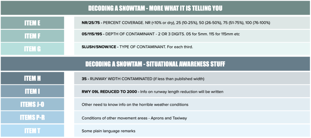
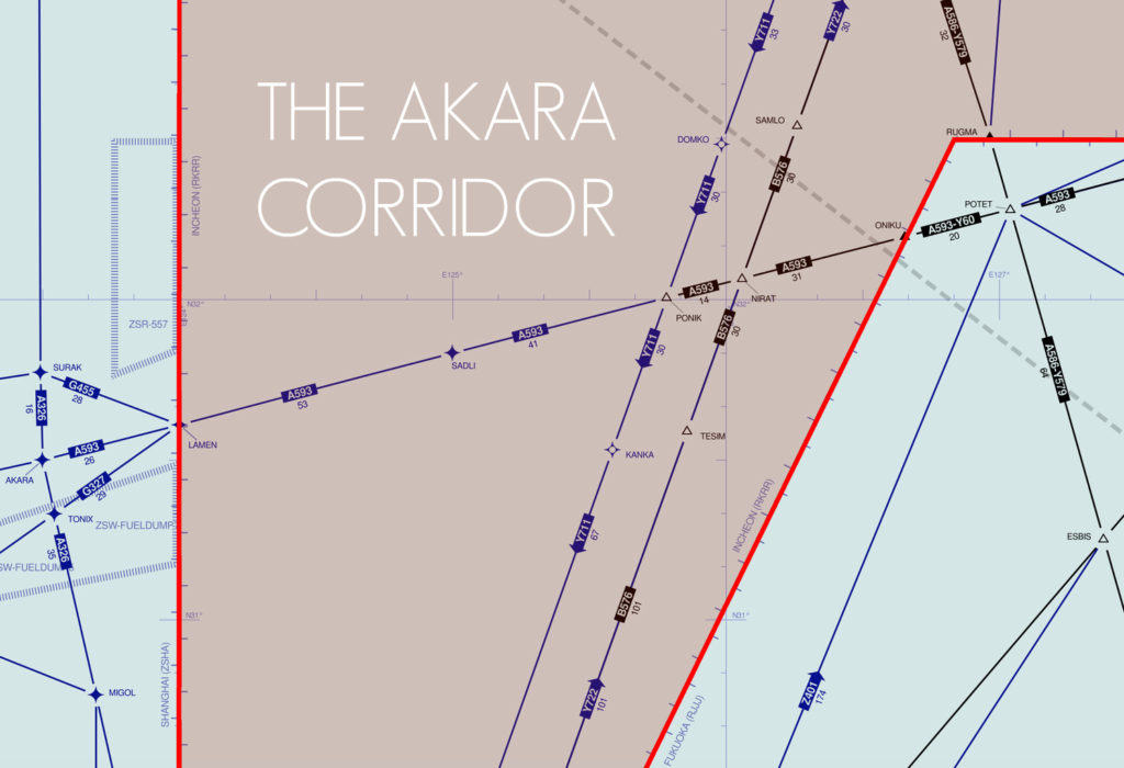
The long-awaited and much discussed scenario on the North Atlantic finally happened this week: No published NAT Tracks, with all aircraft on Random Routes. The concept of free-routing on the NAT is one that airlines in particular have been keen to see for a long time: the ability to decide their own routes, unconstrained by an overlay of tracks that may be tangential to their flight-planning whims.

This is an experiment being led by NATS and Nav Canada (or Shanwick and Gander, if you prefer), and on the face of it, it appears straightforward. Traffic levels are lower at present – about 40% of normal. In January 2021, Shanwick managed 15,241 flights (averaging 491 flights per day), 41% of the January 2020 figure of 36,782 (averaging 1,189 flights per day). A reduction in volume goes hand in hand with a reduction in complexity from an ATC perspective. Without published tracks to assist in separation, the burden on the controller is increased – but the lower traffic levels mean it can be safely managed. Ideal time to try it out.

The concept has garnered much media interest, not least because of the timing of a scientific research paper from Reading University that suggests efficiencies of up to 16.4% can be achieved with this “new idea”. As a result, in the past 10 days the NAT Tracks have featured on CNN (“Airlines can now pick their own routes across the Atlantic. Huge fuel savings could follow”) and the Independent (“‘Surfing the wind’ could allow aircraft to cut carbon emissions and reduce flight times”). Headline: New York-London journeys could be cut by 21 minutes.

The media, and even our own industry news coverage, would have us believe that somehow we’ve just stumbled onto some preternatural scheme of harnessing the power of the wind, to spirit our hulking lumps of metal across the pond. Jet streams, you say? Pray tell.

Let’s clarify something first. Aviation contributes around 2% of global CO2 emissions. Global warming is a danger to our entire existence. We are an industry founded on innovation and ingenuity, and we should be looking for every opportunity to do something more than just shave a few dollars off a route cost. We need to open our minds, stop being quite so defensive about aviation, collaborate with science and research, and above all recognise the impact that aircraft are having on the environment. We need dramatic change.

In the cold light of operational reality, however, all is not as the public coverage seems. The Shanwick/Gander No-Tracks experiment itself is founded on solid ground – the results will provide useful insight, and the reasoning for it is sound. The research paper, however, and associated media fanfare, has shakier foundations. In fact, there are fundamental flaws in the assumptions made to reach the headline proclamations of 16.4% and 230km (125 nautical mile) savings on route distance.

We’ll look at three things in this article …

One: How an aircraft operator actually chooses a route across the NAT
Two: The ATC perspective; why No NAT Tracks is not as easy as it might sound.
Three: A review of the research report from Reading University.

Part One: How does a NAT route get chosen?

The hardest thing in life is knowing what you want. It’s no different on the NAT. The process for selecting a route across the ocean is more complex than it might seem. At first glance, it might appear that the most logical route is the best wind route, in other words, the track across the ocean where we can take maxium advantage of the jet stream. In the Reading University report, this is called the “OFW: Optimized for Wind Route“. Let’s see why this is not the case.

There are four track calculation options available to most aircraft dispatchers and flight planing systems:

A. MDT: Minimum Distance Track. Departure to destination with shortest distance (ie. Great Circle track). Only sensible if there is no wind, which never happens.
B. MFT: Minimum Fuel Track. Departure to destination with lowest possible fuel burn. Equivalent to the OFW/Optimized for Wind Route.
C. MTT: Minimum Time Track. Departure to destination in shortest possible time. Often very similar to the MFT.
D. MCT: Minimum Cost Track. Departure to destination with lowest cost – considering not just fuel, but navigation fees, and the cost of time (eg. knock on schedule effects, missing curfews etc.)

Which is the most commonly used? Minimum Cost Track, by far. Minimum Fuel is good. But for aircraft operators, we have to consider whether saving 100 kgs in fuel results in being 10 mins late to stand, or makes us overfly a much more expensive country, or miss a curfew time at the airport.

A North American OPSGROUP airline dispatcher told me: “To give you an idea of cost, a Minimum Time Track (MTT) or Minimum Fuel Track (MFT) for our Boeing 777 from the west coast of North America to east Asia can cost anywhere from $10,000 to $15,000 more than taking an MCT. The difference? The MTT and MFT will go through Russia [where navigation fees are much higher]. The MCT stays on the North Pacific in Oakland and Fukuoka airspace. But that cheaper route can be 30+ minutes longer.

And even then, that’s not the track the operator might want to fly. One big consideration: Turbulence.

In the winter months in particular, the eastbound jet stream can be nasty. The place where the most efficient route lies is efficient because that’s where the winds are strongest. This is often also where the core ‘efficient’ NAT Track Xray or Zulu lies these days. A 200 knot tailwind is great, but it comes with a sting in the tail: severe turbulence. The same dispatcher told me: “In the last week, we’ve not flown the NAT Tracks because of multiple patches of severe turbulence, both forecast and reported by other airlines”.


Planning a real-life NAT route from start to finish: eight steps

We’ll look at an eastbound flight from New York Kennedy (JFK/KJFK) to London Heathrow (LHR/EGLL). Given that the research paper mentioned above identifies maxium fuel savings eastbound of 16.4%, this is a good example to choose. On the maps that follow, you will see the there are eight steps, starting with the great circle track, and working through what happens in practice until we reach the actual route flown. The aircraft in this example is a Boeing 787, which has an optimum altitude of FL390 (presure level of 200 hPa) at operational weight (~85% of MTOW). Therefore, the winds shown are those at FL390. For track planning, we will consider only the track from Top of Climb (first point of cruising altitude) to Top of Descent (beginning of descent into LHR). The map also shows the ATC areas that will control the flight in the enroute phase. The jet stream is shown as background: the whiter, the faster.

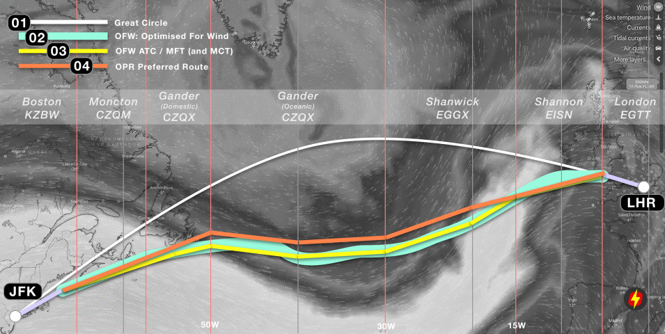
01: GC: Great Circle Route. The shortest distance between JFK and LHR. This does not take winds into account, so to find the best wind route, we must add wind from the forecast for FL390 for our time of flight.

02: OFW: Optimised For Wind route. The track taking maximum advantage of the winds at FL390 (39,000 feet, or the 200 hPa pressure level in ISA).

03: OFW ATC route. The OFW route as adjusted for oceanic ATC flight planning limitations – which are: 1. You must use fixed 1/2 degree latitude points at every 10 degrees of longitude from Oceanic Entry Point to Oceanic Exit Point. 2. You must fly a straight line from that point to the next 10 degree longitude line. This route equates to the MFT (Minimum Fuel Track) in flight planning systems, and in our case here, also the MTT (Minimum Time Track). For some NAT routes, overflight fees will be a consideration (for example, avoiding higher charges in UK and Swiss airspace on routes that go further into Europe) – but here, they are not, so MCT (Minimum Cost Track) is also the same. In other words, OFW ATC = MFT = MTT = MCT.

04: Operator Preferred Route. The next big consideration is turbulence. In this example flight, there are moderate-severe turbulence warning patches at several points on the ATC OFW/MCT route above, so the dispatcher elects to move it a little further north – still gaining from the eastbound jetstream, but outside the core jetstream which has the highest turbulence.

We can now move on to the next stage of planning in a real-world scenario: accounting for a high volume of other traffic, ie. matching the Operator Preferred Route to the closest NAT Track of those published for the day of flight.

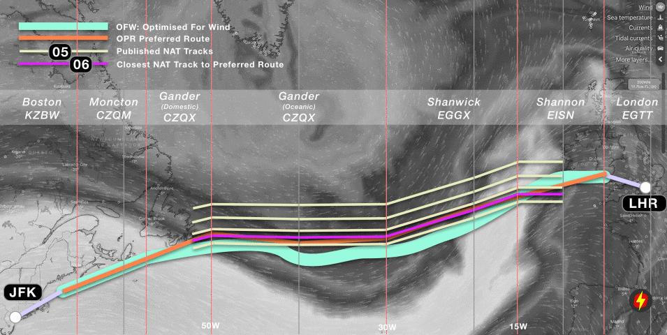
05: Published NAT Tracks. Once a day, Gander issues the NAT Track Message for Eastbound Tracks, which allows Air Traffic Control to safely separate the peak flow of flights from the US to Europe. In this case, there are five tracks.

06: Closest NAT Track to Preferred Route. This is a simple calculation – which NAT Track most closely matches the Operator Preferred Route across the ocean. In this case, it is highlighted in purple, and is a relatively close match.

Finally, we can account for what will happen at the time of flight …

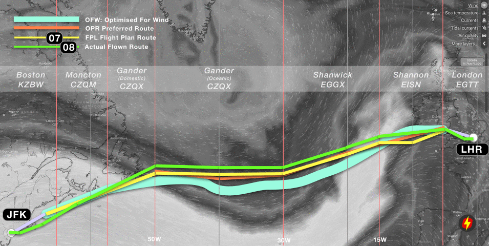
07: Flight Plan Route (FPL). With the choice of track made, the operator will then file the Flight Plan with their requested route, several hours in advance of the flights’ departure from JFK. The purple track above at Step 6 (closest NAT Track) becomes the yellow track in this step, to which the domestic ATC routings are added. Once airborne and enroute, about an hour from the Oceanic Entry Point at 50W, the crew will request their Oceanic Clearance from Gander, as per this flight plan route.

08: Actual Flown Route.  For this flight, the requested track was not available at FL390 (because of other traffic ahead). The crew were given a choice of either a more notherly NAT track at their preferred level (FL390), or their requested NAT track at FL370. The altitude difference would have made for a greater fuel burn than a slightly longer distance, so the crew elected to take the more northerly track (30 nautical miles further north laterally, but in terms of distance flown adding about 20 nautical miles). At 15W, the flight is under radar coverage from Shannon, and was cleared direct to the Strumble (STU) beacon in Wales (which was the original planned Top of Descent). The green track therefore depicts the actual route flown.


Where did we lose most efficiency?

Since the background to this article is considering the benefits of not having to follow prescribed NAT Tracks, the key question is – where has most efficiency been lost on this flight?

  1. Loss 1: The difference between the Minimum Fuel Track (MFT) (or “ATC OFW”) and the Optimized for Wind Route (OFW). Some efficiency is lost because the OFW is constrained by flight planning requirements – specifically having to flight straight lines between each 10 degrees of longitude, and having to cross each 10 degrees of longitude at 1/2 degrees of latitude. The “route of straight lines” is, of course, longer.
  2. Loss 2: The difference between the MFT and the Operator Preferred Route. In this case, the operator chose to move the track further north to avoid turbulence. This decision creates an efficiency loss in terms of fuel burn, because the minimum fuel track is no longer being followed.
  3. Loss 3: The difference between the Operator Preferred Route and the closest matching NAT Track. This is the key efficiency difference when considering gains from the “No NAT Track’s” experiment.
  4. Loss 4: The difference between the NAT Track requested (Flight Plan Route) and the Actual Route flown. There is a mixed bag here. On the one hand, if the operator has to fly anthing other than the requested route, they lose efficiency to some degree. In this case, ATC could only offer a lower level, or a more northerly route. On the other, domestic ATC (using radar) often provide shortcuts which lessen the track miles flown.

A scientific analysis of a series of actual flights would reveal the numbers involved in the four different areas of efficiency loss – and this is roughly the aim of the OTS NIL experiment that Shanwick and Gander are conducting,


Part Two: Why we might still need NAT Tracks

The narrative in the majority of recent reports about the North Atlantic tell us that because we now have ADS-B satellites, and thereby excellent surveillance, this changes the entire landscape, and allows for the disbanding of NAT Tracks. But this overlooks a key point: it’s not a surveillance problem, it’s a comms problem.

We’ve got surveillance nailed – it’s basically the same as radar, now that the full complement of Aireon ADS-B satellites are up and running, complementing the ADS-C coverage already in place. So, controllers can see the aircraft in much the same way as a domestic radar controller. That’s exciting.

However, it’s a bridge too far to assume that just because surveillance is good, we can start treating the Air Traffic Control of NAT aircraft as if it were somewhere in the centre of Europe.

And the reason: instant communication. In a domestic ATC environment, the approximate sequence of events goes like this (callsigns dropped from some calls for clarity):

Controller (thought):Hmmm, Delta and Speedbird are getting a little close. I’ll climb the Delta.
Controller: Delta 63, climb FL360.
Delta 63: Sorry, unable 360, we’re still too heavy.
Controller: Delta 63, roger, turn right 10 degrees due traffic.
Delta 63: Roger, right turn heading 280.

And Delta turns. Conflict solved. That entire sequence of events takes about 10 seconds. Now consider the Oceanic environment. CPDLC is a hell of a lot better than HF, but the target time for the same sequence of events is 240 seconds, or 4 minutes. That’s the basis of RCP240.

See the ATC problem? We can see the traffic now, but we can’t be sure that we can move it around in the same way as a real radar environment, because we don’t have VHF.

This is why the new satellite coverage does not go all the way to allowing a full reduction in separation to the standard enroute value of 5 nautical miles. Oceanic ATC, even with this additional surveillance, remains more of a procedural environment – and separation standards cannot yet drop. In the same vein, we’re not yet at the point where we can solve enroute conflicts with a few vectors and “on your way”.

And therefore, removing the NAT Organized Track Structure for high volumes of traffic is a big challenge.

Part Three: The Reading University Report

Published in January 2021, a paper from Reading University titled “Reducing transatlantic flight emissions by fuel-optimised routing” suggested that “current flight tracks [on the North Atlantic] have air distances that are typically several hundred kilometres longer than the fuel-optimised routes”, that by using the optimal wind route eastbound flights would save on average 232 km, and that an efficiency gain of up to 16.4% would be possible. These headline figures are the ones taken by the media in the last few weeks resulting in articles suggesting that the average New York-London flight could arrive 21 minutes earlier [Independent >].

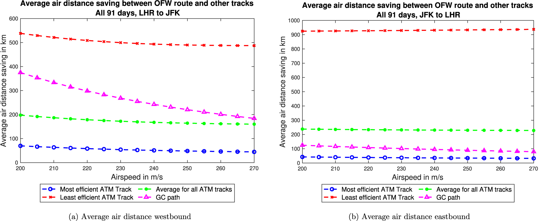
The paper shows these graphs, with the eastbound plot on the right:


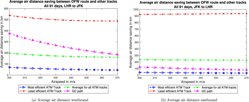
From an operational perspective, however, the promise of 232km (125nm) average route savings, and 16.4% increases in efficiency do not ring true. If you are a dispatcher, or pilot, you will share my instinct that this number feels extremely high.  The term “potential increase in efficiency” really means “current inefficiency” – and my gut feeling says it’s not always ideal, but far from that bad. Many plans are indeed sub-optimal, and crossing the NAT certainly has the potential to result in a track a half-degree north or south of the one requested or a level below the optimum – but is the inefficiency really that high?

Closer analysis shows that at least some of the assumptions in the report to be fundamentally flawed.

The report itself makes the flaw clear here: “Taking the results for an airspeed of 240 m s−1 and averaging savings in air distance between the most efficient ATM track and the OFW route across all 91 days of winter 2019–2020 for flights from JFK to LHR, gives an air distance saving of 37 km, but the saving for the least efficient ATM track is over 931 km. The average saving for all ATM tracks is 232 km”

The problem is that to reach these high numbers, the paper is assuming that “airlines use all provided tracks equally“. This is not what happens in reality, by any stretch. There are normally 8-10 NAT Tracks eastbound. An airline, or aircraft operator will request their Preferred Track, as we have seen in the example above. Almost all of the time, the requested track is granted, albeit with potentially a lower level (or higher) than requested. Very ocasionally, a track one north or one south is given by ATC.

The efficiency figure of 16.4% is created by dividing the air distance between LHR-JFK by additional distance flown on the least efficient eastbound NAT Track (2,997nm/503nm ~ 16.4%). That least efficient NAT Track (which will usually be Track Zulu in non-Covid ops for an eastbound flight) is normally a southerly Caribbean area route intended for traffic departing places like Miami, the Bahamas, or even Trinidad and Tobago. It will never be flown by a New York-London flight.

Therefore, we have to disregard these higher numbers entirely.

The report does identify, when looking at actual flights, that efficiency savings of “2.5% for eastbound flights and 1.7% for those flying west” would be obtained by flying the optimum wind route (OFW). Those numbers look far closer to what we might expect as total efficiency losses identified at the end of Part One, above.

However, consider further that we looked at four different types of efficiency loss: flight planning constraints, avoiding turbulence, the NAT Tracks requirement, and tactical routing by ATC. It is clear, then, that the presence of the NAT Tracks accounts only for a portion of those inefficiencies. Again, real world analysis of actual flights with the full compendium of information as to what caused the ineffciencies would give the most insight, and this is what we will hopefully see from NATS and Nav Canada as a result of the “OTS NIL” experiment.

A further paper as an iteration of the first, applying a collaborative approach with the operational world (ATC, Airlines, Aircraft Operators, Flight Crew), would be beneficial.

Over the past 25 years, there has been continual improvement in ATC efficiency. The NAT region was the first to implement reduced vertical separation (RVSM), in March 1997, and subsequent improvements in surveillance (ADS-B, ADS-C), and communications (CPDLC), have led to lateral separation improvement from 60nm to 19nm, and longitudinal from 80nm (or 10 minutes) to as low as 14nm – in addition to the altitude separation reduction from 2,000 to 1,000 feet. In simple terms, the number of aircraft that can fly closer to the optimum route for a city pair has dramatically increased.

Despite the inaccuracies in the numbers, we should look at the bigger picture: The paper does identify a key point that we should digest in this industry: “Airlines currently choose routes that minimise the total cost of operating a flight (by specifying a Cost Index, which is the ratio of time-related costs to fuel costs), not the fuel consumption or emissions.”

This, I think, is important to consider. We are not currently flight planning to minimise emissions – we flight plan to minimse cost. With the reality of our warming planet, and the thankfully growing recognition that a corporation’s profit should not come ahead of the greater good of humankind, focus should be placed on how we can operate flights more efficiently – where ‘efficient’ does not mean reduced costs, but reduced emissions.


Stop droning on

Drones are big news. They are changing the way we can look at the world with their surveying and photography capabilities. They are changing the way we deliver things – offering services to previously unreachable areas, improving the carbon footprint of our McDonald’s home deliveries…

They are also changing the way we think about airborne hazards because it is no longer just large birds and escaped helium-birthday balloons we have to worry about. From nuisance traffic disruptions at airports, to attacks using ‘weapon laden’ UAVs – drones present a new and potentially growing problem to the aviation industry.

How big is this problem?

Back in 2018, EGKK/Gatwick (the second biggest London airport) closed for 33 hours, resulting in 1,000 flights cancelled and around 140,000 angry British people left standing in queues (ok, they probably weren’t all British, you do get some tourists who, for reasons unknown, actually choose the UK as a holiday destination).

Anyway, what ruined the travel plans of 140,000 people? Yep, a drone. It was spotted by an eagle-eyed security officer who was waiting at a bus stop for his ride home. He noticed two drones hovering around the perimeter fence and alerted airport operations.

The UK isn’t the only place that has suffered from pesky drones sneaking into airspaces they should not be a-sneaking into. The UAE has seen multiple airspace closures over the last few years, costing them a whopping 350,000AED a minute in disruption costs at OMDB/Dubai International alone (that’s about $95,000).

The US has also had its fair share of drone incidents. KEWR/Newark Airport was forced to briefly close in 2019 after two drones strayed too far into its airspace. One pilot reported spotting one less than 30 feet from the aircraft. A quick look at the FAA drone sightings report shows 366 across the country just in the October to December period. That is more than 100 a month.

In fact, there are close to a million  recreational and commercial drones registered in the US alone and those drone sighting reports received by the FAA are increasing by upwards of 50% each year.

In 2020, a 26kg drone went rogue in Latvia and was missing for several days resulting in Latvia having to restrict airspace below 19,000’ until it was relocated.

The mystery rocket man who made headlines last year after appearing thousands of feet in the air in KLAX’s airspace night not have been human at all, but instead a large drone made to look like a person…

What is the BIG problem?

Simply put – collisions!

But airspace is not closed every time a large vulture is spotted swooping about, so why are we so concerned about potentially hitting a little buzzing drone? 

Well, a small photography drone (your DJI Mavic type) weighs less than 1 kg (734g according to the online specs). A pigeon in comparison weighs between 300-615g depending on how much old chewing gum and fries it has chowed down in its greedy little life. So not too threatening, but is going to cause some damage to your engine if flies into it, but the difference between a drone and a bird is the bird probably doesn’t want to go into an engine and sort of tries not to. A drone (or rather the person controlling it) might want it to.

Drones can also be much bigger than a fat pigeon. Something like the Wing drone (which Amazon use) weighs about 5 kg, and can carry another 2-3 kg in cargo. It also has a 3 foot wingspan. The Whooper swan (Whooper, not whopper) variety, fully grown, weighs between 8-11kg and have a wingspan of around 2-2.8m. So, these are basically the same size as a teenage Whooper and I would not fancy one of them zooming into my engine.

If you still are not convinced, then check out this video

Bigger than a very small swan

But they are under control…

Yes, they are, and Amazon have gone through a lengthy process to get their approvals. We are not concerned about Amazon drones. What we are concerned about are the drones that anyone can generally get their hands on nowadays which are not registered, and which are being flown where they should not be flown.

We are also very, very worried about the sorts of drones being weaponsied and used to attack targets. Drone attacks seem to be a constant news item, particularly in Saudia Arabia where Yemeni rebel forces are regularly sending drones into OEAB/Abha Airport, throughout the southern Jeddah FIR and even as far as OERK/Riyadh airport.

We wrote about this a while ago. It is still going on, and these pose a big threat to aircraft operating in the area. 

So what can the industry do about it?

One of many drones intercepted by Saudi Air Defence Forces

Pest control

It turns out there are over 530 different commercially available technologies out there designed just for the purpose of drone spotting and ‘swatting’. Broadly speaking, anti-drone technologies have to achieve two things – finding a drone, doing something to it when they do.

In August 2020, the FAA announced they would start to evaluate technologies and systems that could detect and mitigate potential safety risks posed by unmanned aircraft. Basically, stuff to Spot and Stop ‘em.

Ten of these technologies have proven promising enough that they will now be trialled at several US airports over the coming months. These trials will take place at KACY/Atlantic City, KCMG/Columbus, KHSV/Huntsville, KSEA/Seattle-Tacoma and KSYR/Syracuse airports.

At EGLL/Heathrow a ‘Holographic Radar’ system called ‘The Gamechanger’ (developed by Alleviant) can detect UAS in 3 dimensions, up to 7.5km away, and can differentiate between drones, ‘friendly assets’ and birds. In case you are wondering, the difference between conventional radar and 3D holographic radar is that the holographic radar illuminates everything all the time – if a conventional radar is the equivalent of a torch scanning a dark room, then the 3D holographic radar is a light that illuminates the entire room.

The Gamechanger

Clearing the skies

‘Detect and Avoid’ systems use technologies like radar, radio-frequency, electro-optical, infrared and acoustics which can spot drones and identify the signals controlling them. The AUDS counter-UAV system, for example, can detect a drone up to six miles away using an electronic scanning radar, infrared and special precision video tracking software. It then uses an inhibitor to block the radio signals controlling the drone. All this can happen in less than 15 seconds, and in any weather condition, night or day, without disruption to the airport equipment and airplane pilot might prefer not to have disrupted.

Recreational drones rely on a radio signal which operate on common frequencies – usually 2.4Ghz or 5.8Ghz, and these are non-assigned public bands. These are east to deal with.

There are also other options like geo-fencing. This technology relies on manufactures programming limits based on GPS into the drone itself based on no fly zones and other flight restrictions. The issue here is savvy owners can bypass the system or just not update it. So a clever solution, but not an ultimate one.

Sadly none of the systems being trialled is just a huge static-charged tennis racket like you get for mosquitoes which is disappointing.

What can you do for now though?

Keep reporting them. Like the laser reporting of old, providing clear info on when and where you spot one, as soon as possible to ATC, means they can get the authorities out to search and stop ‘em.

Also keep an eye on Safeairspace conflict zones, and monitor alerts on drone attacks if you are likely to be operating in those airspaces.


There’s no “I” in team. But there might be an “AI”…

Back in March 2020, Eurocontrol released something called ‘The FLY AI Report – Demystifying and Accelerating AI in Aviation/ATM’. 

Now, the minute most aviation folk hear ‘Artificial Intelligence’ they generally start imagining either a Matrix type world ruled by super computers, or they are a pilot and get angry at the thought of the most ‘know-it-all’ co-pilot possible sat next to them. 

But AI has actually been used in aviation for a while now, and its integration into the aviation operations environment might be rather disappointingly un sci-fi, but it is very NOT disappointingly impressive when you start to see the clever ways it is improving the safety and efficiency in our industry.

The First Law of Robotics

First, let’s establish what is actually meant by the term ‘AI’.

It is not so much Replicant as it is Roomba – ‘Artificial Intelligence’ is used to categorize systems that have the ability to independently gather information, assess it, and (here comes the AI bit) make a decision based on it.

So your Roomba with its camera sensors and ability to make the decision to turn around rather than smash into the wall in front of it means it is categorized as an AI. A basic AI, but still, an AI.

AI is categorized into 6 levels, starting with your Level 0 – Low Automation stuff which just supports a human operator by gathering info and analyzing it. Beef up its brain a little though, and it becomes a Level 1 – Decision Support which not only gathers and analyses, but can also select certain actions in relation to some basic tasks or functions. Like, don’t run into walls.

As the levels increase, so does the ability of the systems to analyse greater data inputs, and the independence of the system to “decide” and act without any human operator involvement at all. Highly complex system are even able to determine what might happen based on data patterns, and so pre-empt actions, making decisions based not on the direct data, but on forecasts and possible things that could happen.

Flying Roombas could help clear up the atmosphere from pollutants

We aren’t talking vacuuming though, we are talking flying…

Actually, for all you pilots out there, we aren’t really talking flying. Not yet. Some airplane manufacturers are toying with automated takeoffs and that sort of thing, but no AI is currently capable of the level of autonomy which would enable it to totally replace Captain McFleshy. What we are talking is systems that support other areas of aviation operations in parallel to human operators – by providing data acquisition, analysis, action selection and implementation.

That all suddenly sounds quite boring, but the functions of AI in aviation are anything but.

The Cat-AI-logue

The cat-ai-logue of uses is impressive

Most of the AI currently implemented in aviation is the “detect and avoid” type – systems that focus on precision navigation, or image detection. Sort of giant Roombas for the aviation world. Here are just a few of the current technologies that might be helping your flight without you even knowing it.

Traffic Prediction

Eurocontrol in Maastricht already use what they call a “learning machine” which can predict 4D trajectories – in other words aircraft position, altitude, speed and time. Being able to predict traffic flows means they can optimize the use of ATCOs and put the people brains where they are most needed.

The clever AI algorithms have a “what if?” function which lets them “tentatively probe” (Eurocontrol’s choice of phrase, not mine) the impact of certain airspace restrictions, or regulations, on traffic flow. It can monitor workload, spot probable bunching points, and also predict traffic one or two hours in advance to work out how the handover between different control sectors might affect the flow.

Maintenance Costs and Fuel Optimization

An AI system produced by Honeywell is being used to save airlines up to $200,000 per aircraft per year in fuel costs, and up to $40,000 per aircraft per year in maintenance costs. The system has data gathered from years and years of flight statistics, across a whole bunch of airlines, and it has swilled all this data about in its big brain and can now take specific flight plans and review where fuel has been wasted before.

The system can not only determine better routes, but can help make strategic decisions on things like flight path routings, the best direct path to landing to take, engine out taxi etc. While the pilot brain is thinking “If I turn an engine off now, will I have to use loadsa thrust on the other one to get it up that hill and around the corner? Maybe I should just keep ’em both running…” the AI brain is going “click, whirrr, yeah, turn the engine off now and you’re good!”

GNSS Monitoring

GNSS is great – it lets us operate the approach, landing, departure, ground stuff in low vis conditions. But there is a big issue with it –  propagation delay caused by the ionosphere. The current models for gathering data on this are pretty limited, but a new AI system can monitor and gather so much more data, and assess it so much more quickly because it has the ability to ‘learn’ – it is not just looking at data and spitting out figures. It is constantly updating its analysis.

Image recognition to detect runway vacation

Yep, there is an AI system that is used in conjunction with digital, remote, tower operations. It can speedily determine if the runway is clear, and calculate whether there is time for the next aircraft to land or not – it can do this a lot more efficiently than person eyeballs and brain, meaning airports can be a lot more efficient, and flight delays reduced, without reducing safety.

100 million actual flight hours of experience

A system developed by Thales – PureFlyt – has the ability to draw on aircraft and outside world data like weather information. It works inside the FMS and can predict aircraft trajectory, and can offer optimized flight paths to decrease fuel consumption and improve passenger comfort, as well as maintaining safe separation from other aircraft.

AI technologies have simulated 2 billion test cases. So this system basically will have the brain of a Captain who has flown 100 million flight hours (and all the knowledge that would go with that experience).

What are the risks?

Supplementing not replacing

Well, automation and AI taking over and forcing humans into pots of jelly where they sap our energy seems unlikely. But there is the risk of oversight, or rather lack thereof. An AI, no matter how “intelligent”, is a system which people have programmed and inputted data into. Poor data in = poor data out.

So the quality and reliability of systems must always be closely monitored. And there’s a thin line between it supplementing operations versus it becoming the single system that people rely on and no longer control. The trick will lie in the training, and in how people interact with the systems – ensuring they understand them, and that strong contingency procedures remain in place.

AI offers new safety and security indicators that can support the early detection and predictions of new risks. It can improve performance by assisting people areas like data gathering and analysis where an AI brain is far quicker than the human brain. But the purpose is not to remove the human operator from the process, but to combine the best of computational methods and human intelligence to create a collaborative service provision.

The full FLY AI report from Eurocontrol is available here.


The Seven Deadly Things

Have you ever taken a look at a report listing the distribution of Accidents by Accident Category? There are apparently more than 40 possible ways an accident can be categorized, but there are 7 that seem to pop up way more often than any other.

Airbus took a look into all fatal and hull loss accidents which occurred between 2009 and 2019 and the results are shocking in that a lot of those accidents just should not have happened.

P is for…

Yep, pilots. We are a big problem. We mess up a lot. That is what seems to be said in the media anyway…

But, it isn’t always our fault, (sadly some of the time it also is), and we all know that the news reporter’s favorite phrase “pilot error” (or “human error” if they are feeling particularly generous about it) is rather meaningless, and very unfair.  It removes all the context of the why’s and the how’s of what led to a pilot making an error, and it is rarely ever as simple as “they just messed it up.”

There are usually countless small things that lead up to any incident, and many a CRM course has been spent discussing and brainstorming how we can better avoid all of these little things and so avoid it ending up in a “one big thing” event.

So, why are these big events still happening? And what can the pilot in the equation do to prevent them? (Because the vast majority of these definitely are preventable).

Taken from the Airbus report

1. Loss Of Control In Flight

This is the single biggest cause of fatal airplane accidents in this period, accounting for a scary 33%, and 12% of hull losses. We are not talking about situations where something major has broken or failed – we are talking about times where aircraft have somehow managed to get into a situation they shouldn’t be in, and the crew have not able to safely get them out of said situation.

Air France Flight 447 is one of the most discussed examples of this occurring.

All these accidents no doubt had other factors involved – it was not just the pilots not knowing how to fly. There were things like startle factor, bad weather, other warnings, other traffic…

But a large number of these could have and should have been recoverable.

So, what can we do about this? Well, ICAO took an in-depth look at why these kept happening, and they came up with a great and simple thing – UPRT. 

Upset Recovery and Prevention Training

When they say simple they really mean it – all you really need to know is PUSH, ROLL, POWER, STABILISE (and maybe have had a few practice goes in the sim).

This is the recovery though. It is the point when everything has gone wrong and all you have left is fixing it.

Luckily, we pilots do have a few other tools in our toolbox which we can pull out earlier at a time when prevention might still be possible. Things like good monitoring, situational awareness, an understanding of startle factor.

In fact, we have a post right here if you’re up for some more reading on the old startle thing.

There is also that Other thing we can do. It might be one that makes a few palms get a little sweaty at the thought of it – but we can disconnect the autopilot and actually hand-fly now and then.

Thanks for the photo, AIN. Not a nice sight to see, but rather in a sim than real life…

2. Controlled Flight Into Terrain

Second on the list of the ‘7 Deadly Things’ is Controlled Flight Into Terrain. Again, not because something has broken, but because a crew have just totally lost their situational awareness. These account for 18% of all fatal accidents, and 7% of all losses reviewed in the 20 year period.

The Korean Air Flight 801 accident report offers more insight into how these occur.

Again, other things factor into this – distractions, visual illusions, somatographic illusions – and these can be tough to handle because they are one of the few things a simulator cannot realistically simulate.

We have backups though. GPWS for one. Although this really is the final layer of the safety net. If this is going off then you’re out of the prevention and well into the recovery and mitigation part of the accident curve.

There is good old Situational Awareness again though – this is the stuff of heroes. It is something you can gain, or regain, with a simple briefing. A “What if… then what will we do?” chat. Briefing threats is important, but briefing how to avoid them is even better. Get a bit of CRM in and ask the other person next to you what they think you should be looking out for.

Situation Awareness is knowing where you have told your plane to go but, most importantly, it is knowing if it is actually going there (and this means vertically and laterally).

3. Runway Excursions

These account for 16% of fatal accidents, and a whomping great 36% of hull losses. No failed brakes or issues with steering involved, just big old “oops, didn’t check the performance properly” type situations. We have mentioned this before. It is one of the biggest “that just shouldn’t have happened” types of event.

Actually, the biggest thing that leads up to runway excursions is generally unstabilised approaches.  These are something we can definitely avoid and IATA has some great tips on how. Cut out the unstabilised approaches and you’ll probably cut out a big proportion of runway excursions right away.

There are a few things to help us here too – if you are flying an Airbus then lucky you, because these have a great system on them called ROW/ROP that squawks at you on the approach, and on the landing roll, if it reckons you’re going to go off the runway. But if you don’t have this, then checking your performance properly and managing that approach well are going to be what saves you from an embarrassing call to your chief pilot.

There is also a big change to runway friction reporting coming in on 4th November 2021 – The Global Reporting Format, or ‘GRF’ as he is known to his friends. Griff will standardize how runway surface conditions are reported worldwide and with better reporting will hopefully come better awareness of the risks.

Being aware of what you’re landing on is pretty important!

That was the Top 3. What about the others?

The other four are lumped together into ‘Other’ which makes up the remaining 33%. (Actually, 11% of that is ‘other’ others!) Combined, our final four account for 22% of all fatal accidents and 22% of hull losses.

These are:

  • Fire
  • Abnormal Runway Contact
  • System/Componet Failure or Malfunction
  • Undershoot/ Overshoot

Now, I know what you’re going to say – fire probably isn’t your fault (unless you dropped your phone under your pilot seat and then ran over it repeatedly with your chair trying to hook it out again).

But there are still things a pilot can do to help lower the impact of these.

How? Well, by knowing our fire procedures (the what to do if something Lithium Ion powered in the flight deck does start smoking), and by knowing the comms procedures needed to help support our cabin crew if there is something going on down the back. We can also prepare in flight – be ready with something in the secondary flight plan in case we need to suddenly divert.

As for system and component failures, well, the 737Max accidents of the last few years account for a big proportion of this, however, in all cases having a strong systems knowledge and preparing for those “what if?” situations might help save your life one day.

You might have noticed a shift in the training paradigm in the industry, and with good reason – the days of focusing on practicing specific failures in the sims are vanishing and in its place is Evidence Based Training – training that focuses on building the skills needed to handle any situation. If that all sounds newfangled to you then think of it this way – a pilot is there just not to push buttons, but to manage the flight, and these skills are the tools which will enable us to do that.

Fancy reading some more?

  • A full report from IATA on LOC-I can be found right here


ATC service back to normal in Myanmar

Update March 4:

Local agents report that ATC services are back to normal in Myanmar, as most ATC staff have returned to work. Operators overflying the VYYF/Yangon FIR should therefore be getting normal ATC service again now, and the Contingency Procedures are no longer in effect, but be on alert for the situation to change quickly.

Story from Feb 13:

Myanmar is no longer providing ATC service to overflights, due to lack of ATC staff.

Thousands of people across the country are taking part in nationwide strikes and protests against the military who overthrew the government at the start of February, and some ATC staff have joined in.

Local sources estimate that 70% ATC and 80% AIS staff are on strike, with very limited operations at NOTAM offices.

ATC service is still being provided at VYYY/Yangon, the country’s main airport, which remains open for arrivals and departures.

But for overflights of the country (the VYYF/Yangon FIR), all operators now have to follow the Contingency Procedures:

  • 15 minute separation will be applied to all overflights
  • You can only transit the airspace via specific waypoints, airways, and at certain flight levels.

Here are the VYYF/Yangon Notams that carry the announcement:

A0038/21 - DUE TO DISRUPTION OF ATS IN YANGON FIR ALL ACFT ARE ADVISED THAT
THE MYANMAR INT'L CONTINGENCY PLAN FOR ACFT INTENDING TO OVERFLY
THESE FIRS IS IN EFFECT.FLIGHT PLANING MUST BE IN ACCORDANCE WITH
THE CONTINGENCY ROUTES LISTED AND FL ASSIGNMENT.PILOTS MUST STRICTLY
ADHERE TO THE CONTINGENCY PROCEDURES.ONLY APPROVED INT'L FLIGHTS ARE
PERMITTED TO OVERFLY MYANMAR AIRSPACE.(RMK- YANGON INT'L AIRPORT APP
AND TWR CONTROL SERVICE AVBL FOR ALL ARR/DEP TRAFFIC. 08 FEB 12:28 2021 UNTIL
28 FEB 23:59 2021. CREATED: 08 FEB 13:04 2021
A0037/21 - YANGON ACC WILL APPLY 15 MIN SEPARATION IN YANGON FIR FOR ALL
OVERFLY TRAFFIC AND DEP/ARR TRAFFIC DUE TO LACK OF ATC STAFF. MAKE
SURE TO PROVIDE ABOVE MENTIONED SEPARATION OVER ALL CONVERGING POINT
IN YANGON FIR AND MONITOR THE ALL TRAFFIC. 08 FEB 06:30 2021 UNTIL 28 FEB 23:59
2021 ESTIMATED. CREATED: 08 FEB 08:36 2021

Here’s a quick reference map of where we’re talking about:

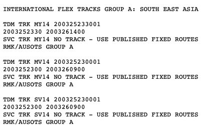
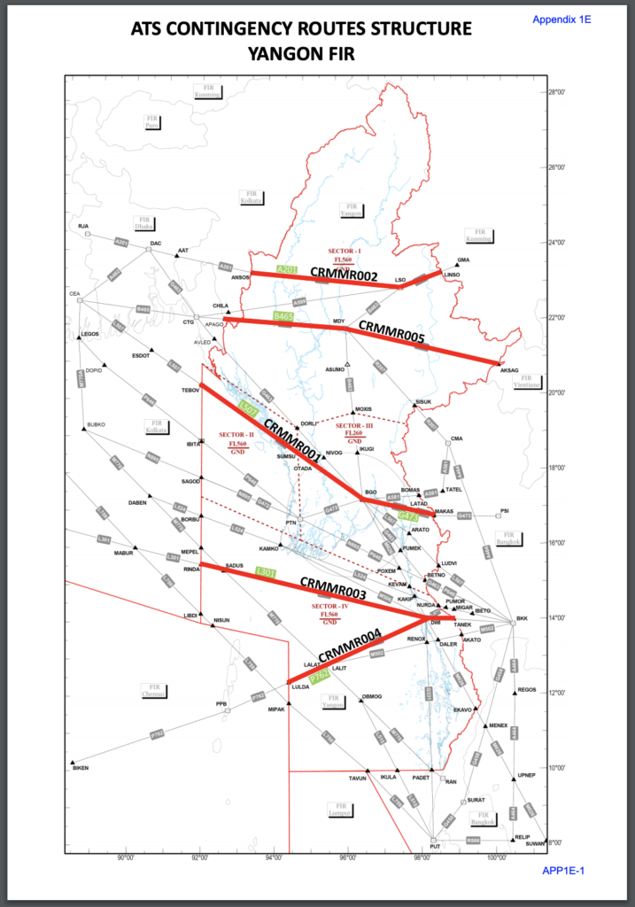
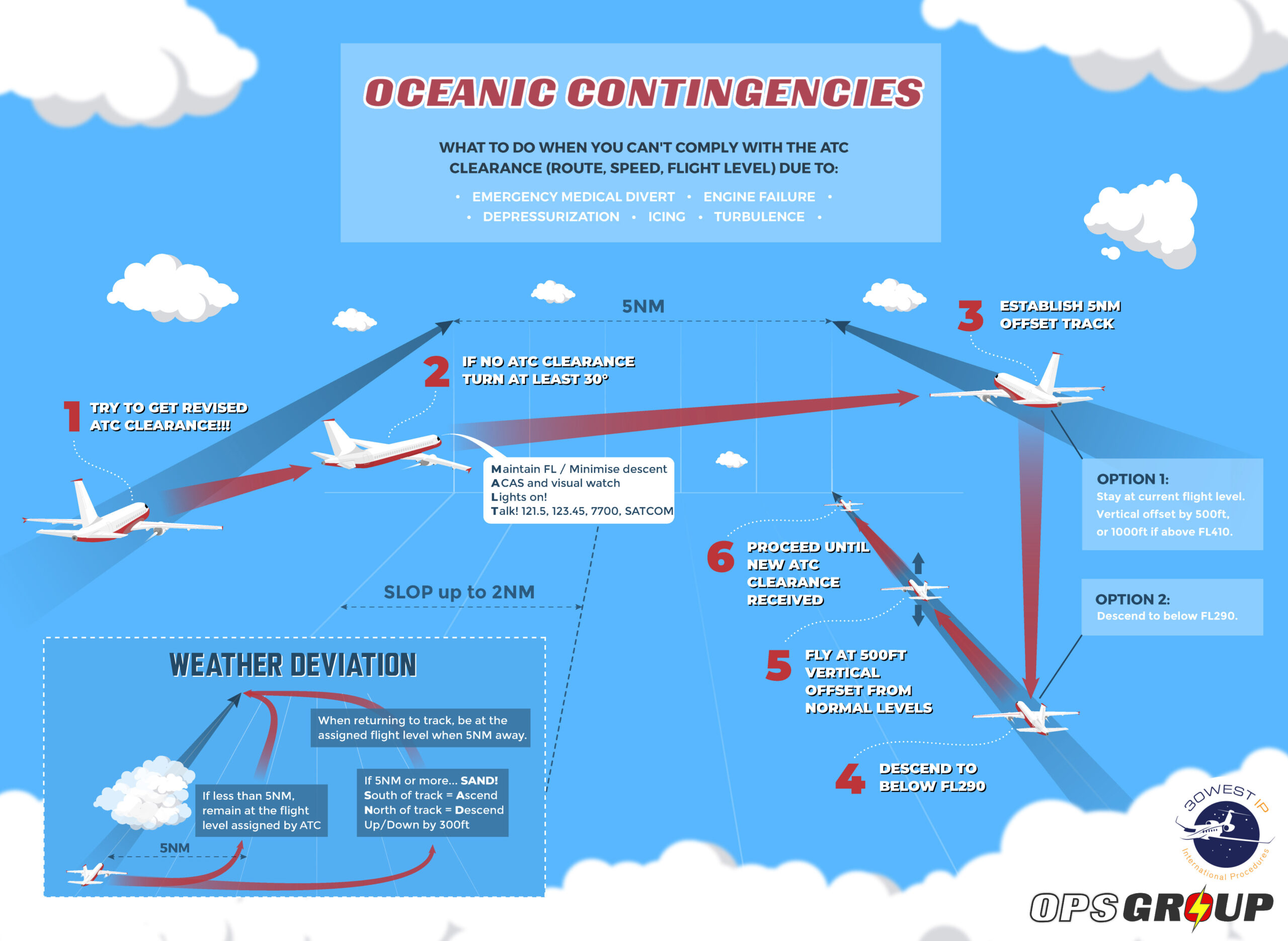
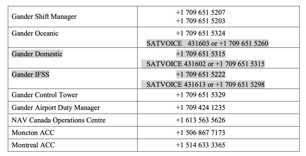
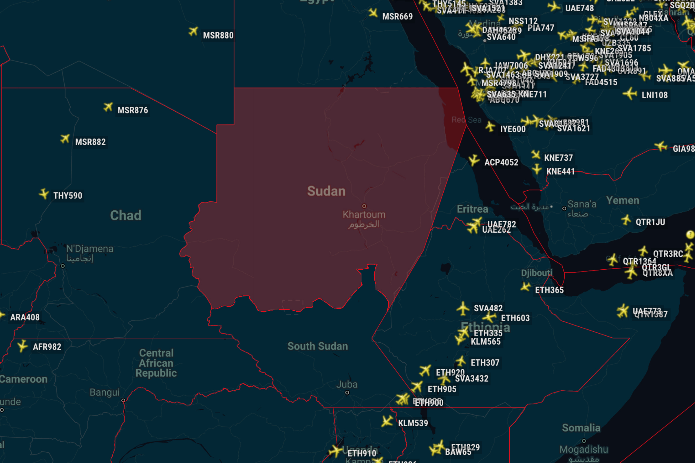
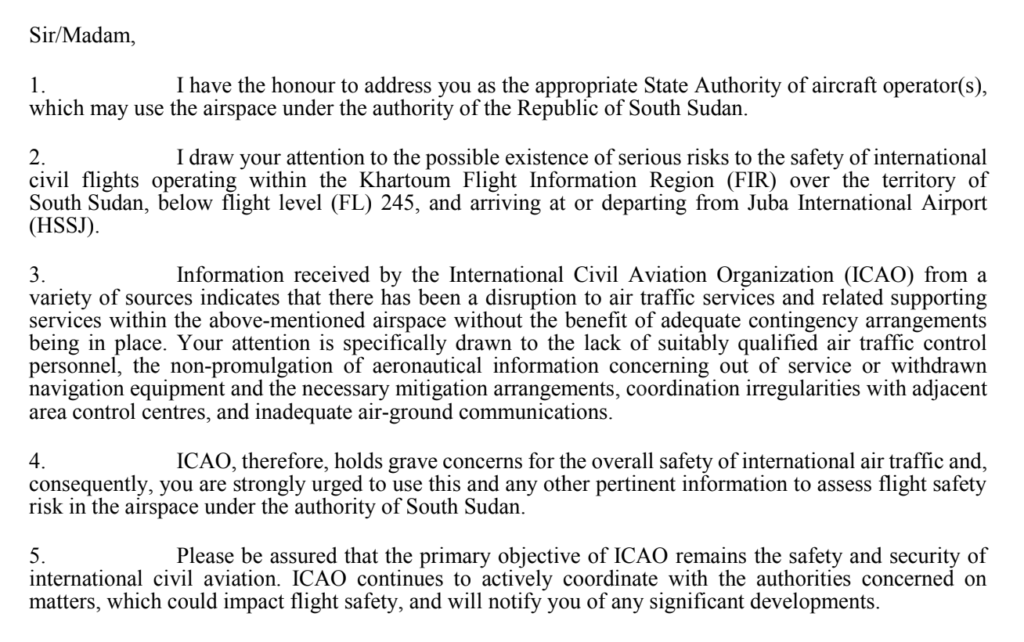
And here’s the info on the Contingency Routes in effect, as published in the Myanmar AIP section ENR 3.5:

Contingency
Route Name
ATS Route Direction FL
Assignment
ACCs Com
CRMMR001 L507, G473
TEBOV-BGO-MAKAS
West bound 320,340 Kolkatta ACC HF, ADS/CPDLC
East bound 350 Bangkok ACC VHF
CRMMR002 A201
ANSOS-LSO-LINSO
West bound 320,380 Kolkatta ACC HF, ADS/CPDLC
East bound 290 Kumming ACC VHF
CRMMR003 L301
RINDA-DWI-TANEK
West bound 300,380 Kolkatta ACC HF, VHF,
ADS/CPDLC
East bound 330,410 Bangkok ACC VHF
CRMMR004 P762
LULDA-DWI-CRY3-TANEK
West bound 280 Chennai OCC HF, ADS/CPDLC
East bound 270 Bangkok ACC VHF
CRMMR005 B465
APAGO-MDY-AKSAG
West bound 300,320 Dhaka FIR VHF/HF
East bound 330,410 Vientiane FIR VHF

Here’s what that looks like in map form:

From the Myanmar ATS Contingency Plan. Click image to download.

Following the coup on Feb 1, the Myanmar Military declared a state of emergency and assumed control. Airports across the country were briefly closed, but a Notam issued on Feb 3 declared they were all open again. The strikes and protests started up on Feb 6, and show no signs of stopping anytime soon – despite a ban on large public gatherings and night-time curfews imposed by the military.

The VYYF Notams say that the current airspace restrictions will remain in place until Feb 28, but given the volatile situation on the ground right now, this could well get extended. We will keep this page updated with the latest news as we get it.

You won’t find the full version of the Myanmar ATS Contingency Plan in their AIP yet – the Myanmar CAA have stored it elsewhere on their website. You can find it here.


Unstable Approaches: Why Aren’t We Going Around?

Late last year, IATA put out a bulletin noting that the number of unstable approaches in 2020 was a lot higher than in previous years.

Look a little further back and you’ll see this has been a trend for some time now.

Fly the line and it’s not hard to see why we are getting unstable – there are a bunch of reasons including weather, other traffic, challenging clearances, complex airspace, fatigue and even currency given the state of the industry, to name only a few.

So what’s the big deal?

IATA also know that in most cases, we’re not going around.

The numbers don’t lie, and they’re scary. Get this – a recent study estimated that 97% of unstable approaches flown in IMC didn’t fly a missed approach. That’s huge.

The leading cause of aviation accidents worldwide are runway excursions. The Flight Safety Foundation looked into all of them over a fourteen-year period and found that 83% of them could have been prevented by a go-around. That’s over half of all accidents recorded. It’s a big deal.

What do we actually mean by ‘unstable’?

In a nutshell it is any approach that doesn’t meet the stable approach criteria in your SOPs by a certain height – usually 1,000 feet off the deck. And it’s not just the ones that have gone badly wrong either – the criteria are usually pretty tight…

Example of typical stabilised approach criteria to be met by 1,000 feet off the ground.

Like the picture, the decision appears to be black and white: If you don’t meet the criteria, you have to go-around.

So why aren’t we doing it?

Good question. There are a bunch of factors but the most important is pilot psychology. Either consciously or sub-consciously we are making a decision to not go-around. Here are some suggestions about what may be happening inside our heads.

1. We’re pilots

Which means we’re mission-orientated. We want to get in and we don’t like conceding defeat. Nor do we enjoy being reminded that we have reached the limit of our ability to fix whatever has gone wrong.

Experience also tells us that if we persist a little longer we can re-stabilise. After all a little speed brake, a little more sink rate you’ll have the thing back on rails long before the runway out the window is too close for comfort.

The problem is we’re fixating on completing the mission.

Studies have shown this behaviour is insidious. It creeps up on you and you begin to normalize the risk. Just like a speeding driver arriving home unscathed, the danger becomes typical. But it gives you far less capacity and room to deal with anything unexpected.

2. Training

A go-around is a normal procedure, but boy do things happen quickly. It’s okay when you know it’s coming. But it’s when you’re off the script that they get especially challenging. Especially after something stressful has already happened.

Studies show that pilots are more reluctant to go-around in scenarios they haven’t practiced. This includes when the aircraft is only partially configured or is very low to ground (such as a bounced landing or botched flare). Complicated airspace and procedures can also be major deterrents to hitting those TOGA switches.

3. What the other guy/gal thinks

Everyone’s personality is different, and we don’t always get along. You might like a good book, while your offsider might prefer a good base jump. When it begins to matter is when it affects safety.

We react differently depending on the dynamic with the other pilot. This can include embarrassment at going around, a lack of support for the decision or disagreement with whether the approach can be safely salvaged. But if you begin to see a go-around as a reflection of your abilities, you are already on a slippery slope. Add an offsider who might judge you for going around and you’re in for a dangerous ride together.

Cockpit gradient is another contentious issue. Too steep and it can turn a multi-crew aircraft into a single pilot one. Age, experience, rank or culture can all contribute. Take this animation of a visual approach on a calm sunny day in San Francisco a few years back. Watch the animation and decide when you would have said something. There were two Captains and a First Officer on the flight deck.

Credit: Airboyd

4. Organisational Pressure

The elephant in the room. No one is pointing fingers but now more than ever operations need to run on the ‘scent of an oily rag.’ Fuel is a big part of that. Crew may be encouraged to carry less of it in the first place which can lead to  fuel anxiety and reluctance to go-around. Or it may be the simple economic cost of using it compared to trying to re-stabilise an approach. It’s no secret that go-arounds use a lot of fuel.

Other factors may come into play too – scheduling, delays, an unwanted diversion or even duty time limits. There are a bunch of external factors which can creep their way into the flight deck and affect our decision making.

So what can we do to improve our Go-Around decision making?

IATA have made some solid suggestions:

1. Make the decision as early as you can. Historically, accidents that follow a decision to go-around usually reflect a late decision. Don’t wander down that garden path. Lion Air Flight 904  serves as another example.

2. Brief the heck out of them. Every time.  Make sure you include what you will be looking for to continue the approach, what may make a go-around more difficult on that particular day and how you will get around those challenges.

3. Encourage acceptance on the flight deck that a go-around is a possibility at any stage. Always prioritise the safest outcome.

4. Follow those SOPs. Operators should always have a mandatory requirement to go-around when stable approach criteria aren’t met. On the flipside, there should never be any punitive reaction to a crew’s decision to go-around. They show good decision making.

5. Fuel policy. Have one which always allows for go-arounds and accept they are a necessary cost of operating an airplane out there.

Up for more reading?

It’s a big issue so there are plenty more places to look. Here are a couple of really good links to get you started.

  • IATA periodically publish a whole bunch of useful stuff about unstable approaches, go-arounds and risk mitigation.
  • Flight Safety’s work on unstable approaches.


Spot The Difference: Oceanic Airspace With Non-Standard Contingency Procedures

On 5th November 2020 the new ICAO PANS-ATM Doc 4444 sprung into action like a super hero in a paper cape. Doc 4444 is the Standard for Air Traffic Management. It is a big deal in the world of documents. It is what provides the worldwide recommendations on Procedures for Air Navigation Services, including those for Contingency and Weather Deviation situations.

But…

That does not mean states have to follow it. They really should. But if they don’t that is ok, they just need to let everyone know in their AIP what their different procedures are.

One Contingency Procedure to Rule them All

So, on 5th November the new recommended Contingency Procedures came into being. In fact, these were the procedures that had been in place in the North Atlantic Region since March 2019. But with the release of the new ICAO Doc 4444, the plan was for these procedures to now be rolled-out everywhere – so there would be one standard set of Contingency and Weather Deviation Procedures for all oceanic airspace worldwide.

The procedure is straightforward: Contingency offsets that previously were 15nm are basically now all 5nm offsets with a turn of at least 30 degrees.

Here’s how it works:

But you know this already, so why are we repeating it?

And that would be great. Pilots, no matter where they are, would know exactly what to do when something goes wrong. But…

Some places aren’t playing by the (new) rules

There are four named oceans on Earth – the Atlantic, Pacific, Indian and Arctic. They are quite big. So big they are often “broken” into North and South as well, and who rules the airspace above said oceans is a mishmash of who borders what bits.

This means while you might just be routing over the Indian Ocean, you might not just be under Indian control, which also means the contingency for each bit of airspace might vary since it is up to each State to decide whether to implement the standard procedure over their bit of the ocean. And not all of them have.

So which ones do we know of that you still need to look out for?

India

India control a big bit of Oceanic Airspace which falls under their VABF/Mumbai, VOMF/Chennai and VECF/Kolkata FIRs.

Until August 12 2021 India did not follow the standard ICAO contingency. From then, they do.

Here is a copy of the new AIP SUP updating their manuals.

China

The ZJSA/Sanya FIR includes an oceanic portion in the South China Sea. It is a “marginal sea” that is part of the Western Pacific Ocean (marginal meaning: would just be the ocean only a bunch of islands and archipelagoes sort of divide it off a bit).

China also do not follow ICAO standard contingencies and instead require you to turn 90 degrees right or left, offset by 25nm and then climb or descend 500ft.

China are pretty strict on deviations and detours. They even use different sized airways in some spots. So check their AIP and China specific Rules and Regs before a flight.

French Guiana

The SOOO/Cayenne FIR extends halfway across the South Atlantic Ocean towards Cape Verde and the West African coastline. The procedures here are also yet to be updated. The French AIP here has the info (ENR section 1.8.5) and tells you to turn left or right by 90 degrees, offset by 15nm and climb or descend 500ft. Nothing strange, but it ain’t your ICAO standard.

French Polynesia

The NTTT/Tahiti FIR in the Central Pacific ocean is another one that comes under the French AIP and still uses old procedures – the now familiar 90 degrees left or right and 15nm offset.

Cape Verde

In the GVSC/Sal Oceanic FIR you are also going to find the old procedures are still in force – the 90 degrees left or right and 15nm offset. You might also want to keep an eye on areas with only 30nm separation and avoid shooting through those 15nm offsets.

Malaysia

The WMFC/Kuala Lumpur FIR Oceanic Airspace requires a 90 degree left or right and 15nm offset

Maldives

They don’t refer to the VRMF/Male FIR as ‘Oceanic’, we think it is so we are not sure on this one. We do know that if you need to do an emergency descent, they want you to remain on away T456. If you are on airways Z653 or Z749 then you can leave the route.

Seychelles

There is a special procedure if you are in FSSS/Seychelles Oceanic FIR. It is in the Seychelles AIP SUP 02/2014. The procedure is a 45 degree turn and a 15nm offset. If you are able to maintain your flight level then once at 10nm, select a level 500′ different to assigned (if at or below FL410), or 1000′ different (if above FL410)

If unable to maintain your assigned level, then pick a level you can maintain and apply the 500’/1000′ difference above, but watch out for aircraft who might be on a SLOP

Where else? We need you to tell us!

If you are flying through a region and spot a non-standard contingency or “different to ICAO” note in the AIP then be a superhero and share it with us, and then we can share it with you all and help keep everyone safe and up to date. Email us at: news@ops.group


Feb 2021 North Atlantic Changes

2021 is off to a flying start again with NAT changes aplenty!

We’ve got a new edition of the NAT Doc 007 (the big one with pretty much everything you need to know in it), Nat Doc 006 (the one which tells you what happens when things go wrong – also pretty big), and three updated NAT Ops Bulletins (the small-to-medium-sized ones which give more info about specific topics).

Words-words-numbers-numbers…

This image shows the docs which have changed – lots of meaningless letters and numbers in there. Fear not, we’ll go through each one and explain what it is, and what has changed

NAT Doc 007


NAT Doc 007 is the Bible of the North Atlantic. It’s full of NAT goodness – all the specifics about how to operate your aircraft safely through the complex airspace of the region is here. And they’ve just published a new edition – effective Feb 2021.

As aviation documents go, it’s written in pretty digestible language. There’s just a lot in it. But the latest release is slightly more user-friendly than previous updates, as ICAO have now included a little summary document which explains all the changes.

You can download a pdf of the new NAT Doc 007 here.

And you can get the little explainer doc here.

We’ve been looking at this latest edition for 12 hours or so now, and we think the changes are minor. We use that word with trepidation. The most significant changes seem to be as follows:

  1. No more NOROTS – these were a system of domestic westbound tracks published daily by Nav Canada for aircraft transiting between Europe and the Northwestern US. These have been disbanded.
  2. Mach Number Technique – they want any aircraft capable of maintaining a mach number to flight plan their requested number (not just turbojets).
  3. The southerly Blue Spruce route which used to start/end at “HO” now does so at “PORGY” instead. HO/Hopedale NDB has been removed from service.
  4. Some clarification on Comms requirements. Basically two long-range comms systems are needed throughout the NAT if outside of VHF coverage. One must be HF. The other may be CPDLC/Sat Voice but Inmarsat systems do not count when you’re really really far north (north of 80N).

Here is latest VHF coverage chart they refer too in Doc 007 (although it says it needs updating):

Relief from the HF requirement is available for flights going for repairs, ferry flights, and special cases. This requires permission from each and every Oceanic Area Control Centre you’re passing through (i.e. Gander, Shanwick, etc). Include your approval in Item 18 of your flight plan.

NAT Doc 006


Also known as the Air Traffic Management Operational Contingency Plan – North Atlantic Region.

Also known as the ATMOCP-NAR.

The dreaded ATMOCP-NAR, spotted on an aircraft wing somewhere over Greenland.

Not really. There’s no such thing as an ATMOCP-NAR.

NAT Doc 006 is about a different kind of monster – it tells the tale of what happens on the North Atlantic when ATC goes down for any reason. It’s the official go-to manual to check the Contingency Plan they put in place during these so-called “ATC Zero” events.

You can download a pdf of the new NAT Doc 006 here.

And you can get the little explainer doc here.

Summary of what’s changed:

  • They have updated the section talking about contingency plans for the Gander Oceanic FIR. There is basically some updated contact info, updated contingency routes in the event of Gander Evacuations, and some wording changes clarifying the procedures to be used in event of a comms disruption or full loss of ground-air comms capability.
  • The plan only applies to Gander Oceanic FIR, and has removed the ADS-B designated airspace over Greenland because Gander no longer provide ground based ADS-B separation.

For a breakdown of each of the big changes in this NAT Doc 006, in chronological order (i.e. following the order they appear in the NAT Doc 006 guidance doc!), check out our separate article here.


So NAT Doc 007 and 006 are the “big ones” that have changed.

But remember, there are some changes to three NAT Ops Bulletins too!

Here’s the lowdown:

1. The “How Not To Make Oceanic Errors” NAT Ops Bulletin


Real name: “ICAO NAT Ops Bulletin 2017-002 Revision 3. Subject: OESB – Oceanic Errors”.

Download it here.

This is the one which has all the advice for operators on how to avoid the common mistakes when flying the North Atlantic. These include: Gross Nav Errors, Large Height Deviations, and Longitudinal Separation busts. There’s also some advice on Flight Planning, SLOP, and some CPDLC things to watch out for.

The changes in this latest version:

  • It now has up-to-date guidance on Contingency and Weather Deviation Procedures, to reflect the new procedures that were introduced on the NAT in March 2019 and then extended to all oceanic airspace worldwide in Nov 2020.

Click here for our article which has more info on all this.

2. The “How To Punch In Waypoints Correctly” NAT Ops Bulletin


Real name: “ICAO NAT Ops Bulletin 2018-03 Revision 1. Subject: Waypoint Insertion / Verification Special Emphasis Items”.

Download it here.

There are some specific procedures to know when it comes to proper waypoint insertion and verification. This is considered a critical method of mitigating the risk associated the rapidly changing procedures (contingency) as well as reduced separation operations (ASEPS and PBCS) within the North Atlantic.

The changes in this latest version:

  • Oceanic Clearances containing a re-route issued by voice/OCL may include half-degree waypoints. Operators should ensure that their flight crew procedures and associated training are sufficiently robust to mitigate against navigational error due to waypoint insertion errors.
  • Flight Crews are reminded they have the option to respond “UNABLE” to an oceanic re-route and negotiate with ATC accordingly.

3. The “How To Use Datalink Properly” NAT Ops Bulletin


Real name: “ICAO NAT Ops Bulletin 2017_004_Revision 1. Subject: NAT Data Link Special Emphasis Items”.

Download it here.

This Bulletin basically gives a tonne of guidance to operators on how to follow the correct datalink procedures in the North Atlantic.

The changes in this latest version:

  • It now includes a new section on the use of CPDLC route clearance uplinks:


So as far as the ICAO NAT Ops Bulletins go, the full list of current Bulletins is as follows:

You can download each Bulletin from the ICAO page here.


And that’s it!! That’s all the changes!! At least, we think so. If you have spotted any biggies not listed here, send us an email at: news@ops.group

And if all this is not enough for you, and you want a comprehensive timeline of all the old significant changes on the North Atlantic stretching back to the dawn of time (2015, actually), then click here.


Feb 2021 NAT Doc 006 Changes

ICAO have published an updated NAT Doc 006, effective Feb 2021.

This document details what happens on the North Atlantic when ATC goes down for any reason. It’s the official go-to manual to check the Contingency Plan they put in place during these so-called “ATC Zero” events.

In particular these include the contingency arrangements in place to deal with:

  • The airspace suffering contamination by volcanic ash.
  • The steps taken to deal with a mass turnback of traffic over the NAT region.

You can download a pdf of the new NAT Doc 006 here.

And you can get the little explainer doc here.

Summary of what’s changed:

  • They have updated the section talking about contingency plans for the Gander Oceanic FIR. There is basically some updated contact info, updated contingency routes in the event of Gander Evacuations, and some wording changes clarifying the procedures to be used in event of a comms disruption or full loss of ground-air comms capability.
  • The plan only applies to Gander Oceanic FIR, and has removed the ADS-B designated airspace over Greenland because Gander no longer provide ground based ADS-B separation.

Here’s a breakdown of each of the big changes, in chronological order (i.e. following the order they appear in the NAT Doc 006 guidance doc!):

The Disruption of ground/air comms capability section was updated:

Shanwick Oceanic FIR and Reykjavik Oceanic FIR provide supporting procedures for Gander. So if there is a general disruption of ground/air comms capability in Gander, comms services will be maintained using available equipment and will be supplemented with the assistance of adjacent facilities. HF normally provided by the CYQX International Flight Service Station will be delegated to other International Stations and the frequencies will be published in a NOTAM.

They then corrected the misspelling of the word ‘dependent’ about 50 times:

Ok, maybe only about 6 times.

The ‘No Service Procedure’ was updated:

If Gander ACC is evacuated, Shanwick will take over the ATC provision in the Oceanic bit as much as they can. They won’t issue re-clearances to aircraft in Gander Oceanic though. Moncton and Montreal ACC will take on the en-route ATC provision in Gander FIR.

Contact Info updated:

Pilot/Operator Procedures were updated:

If you have a clearance already, and are routing in from another OCA, then in you go and follow the clearance.

This is what it says –

“While flights with an acknowledged oceanic clearance may transit Gander’s oceanic airspace, flights not yet within Gander OCA are strongly advised not to enter the airspace. Flights operating with an acknowledged oceanic/ATC clearance that continue under pilot’s discretion are expected to proceed in accordance with the last oceanic/ATC clearance issued. En-route requests for changes to route, level or speed should be limited to those required for flight safety.”

It has removed the bit about flights in other OCAs expecting a big re-route, and how Reykavik and Santa Maria will advise on procedures. The Procedures will be as per the Notam issued and the paragraph above gives the procedure.

East and Westbound flights above FL290 contingency routes have been updated:

The change is that instead of just extending the OTS system to begin at fixes on the boundary between Gander and the Moncton or Montreal FIR, they will now use laterally spaced routes instead and connect them to oceanic exit points in the next agency. Once comms are established with the next agency, you’ll get a re-clearance.

There are a bunch of updated route tables (like this one below). So if you’re initially routing west via AVPUT and Gander evacuate, you will then proceed to NALDI, DUTUM and talk to Montreal for what to do after.

The long term contingency plan changed a bit:

Basically they clarified notes on how evacuations and loss of the Gander ATC service will likely not exceed 48-72 hours. They will also attempt to provide immediate or near immediate resumption of service specially for emergency, humanitarian and critical military flights. Everyone else can expect a “phased approach with flow control.”

Even more contact info was added:

The emergency NOTAM format has been updated:

Everyone loves a big long Notam. Here’s the new one they’ll be using from now on if everything suddenly stops working:

DUE TO EMERGENCY EVACUATION OF [OACC] DUE [REASON, e.g. COVID19] AIR TRAFFIC CONTROL SERVICES ARE UNAVAILABLE IN THE [NAME] OCA. FLIGHTS NOT IN RECEIPT OF AN OCEANIC CLEARANCE SHOULD REQUEST CLEARANCE TO AVOID [NAME] OAC/FIR OR LAND AT AN APPROPRIATE AERODROME. ONLY FLIGHTS OPERATING WITH AN ACKNOWLEDGED OCEANIC/ATC CLEARANCE ARE PERMITTED TO OPERATE WITHIN [NAME] OCA. FLIGHTS NOT YET OPERATING WITHIN THE [AIRSPACE NAME] OCA BUT IN RECEIPT OF AN [OCEANIC] OR [ATC] CLEARANCE ARE STRONGLY ADVISED NOT TO ENTER THE AIRSPACE. FLIGHTS OPERATING WITH AN ACKNOWLEDGED OCEANIC/ATC CLEARANCE THAT CONTINUE UNDER PILOTS DISCRETION ARE EXPECTED TO PROCEED IN ACCORDANCE WITH THE LAST OCEANIC/ATC CLEARANCE ISSUED AND MUST CONTACT NEXT ATC AGENCY AS SOON AS POSSIBLE AND REPORT CURRENT POSITION, CLEARED FLIGHT LEVEL, NEXT POSITION AND ESTIMATE, AND SUBSEQUENT POSITION(S). FLIGHTS MUST REVERT TO VOICE POSITION REPORTING PROCEDURES. DATALINK EQUIPPED AIRCRAFT ARE EXPECTED TO CONNECT TO/REMAIN CONNECTED TO CURRENT CENTRE UNTIL OTHERWISE INSTRUCTED. FLIGHTS MUST MONITOR 121.5 / 123.45MHZ AND VOLMET AND USE ALL AVAILABLE MEANS TO DETECT ANY CONFLICTING TRAFFIC. FURTHER DETAILS WILL BE PROVIDED VIA NOTAM IN DUE COURSE.

Anything we missed?

Let us know. news@ops.group


Currency and Startle Factor – How to Beat It

Good news – the vaccine is here!

Slowly but surely passengers will begin returning to the skies. Which means pilots will too. Just like a huge ship, our industry has inertia. You cannot simply take your foot off the brake and straight back onto the gas.

In 2020, it went into a deep hibernation. Remember those pictures? Thousands of gleaming tails stuck depressingly in the desert? Well, pilots didn’t fare much better. Thousands of pilots were put into deep storage too.

Furlough and redundancy. For now, pilots are much the same way.

To give you an idea of scale, get a load of these stats- the first post-Covid worldwide survey found that 58% of the world’s pilots are currently grounded. 33% lost their jobs completely while a big bunch are on furlough with no clue when they’ll fly next.

So as the industry begins to recover (and it will), a legion of seriously “non-current” pilots will find themselves back in the hot seat facing the same challenges they did back when things were booming and your skills were Chuck Yeager sharp.

Beginning to get the picture? I’ll give you a hint…

It’s not like riding a bike.

The seat may feel familiar, but it’s been a while.

We’re not machines and our skills degrade over time no matter how good you are.

Secondly, you might think a bunch of extra training will soon get you back to speed. The issue is resources – it is such a big task to get everyone current again you are likely to find yourself at the controls legally current, but not necessarily at your best.

So if something goes wrong, you’re likely to be further behind the 8-ball. So let’s talk about startle factor. Yep that old chestnut. We’ve all been there. Something has gone wrong and fast. One minute you’re talking about that great place that does burgers near the crew hotel, the next you’re seeing more red lights than Amsterdam. For a fleeting moment all that training and knowledge is gone. You go blank but feel compelled to act. Sadly it is in these brief moments that some crew have tragically become unstuck.

Here’s the issue.

When you’re not current you are more likely to fall victim to startle factor. And you can bet your bottom dollar that whatever is about to happen is not going to wait for you to get a few sectors under your belt first.

So if I get a call up next week, what can I do about it?

  • Understand what is happening in your brain when something goes *bang*.

    Startle factor is normal. It affects everyone because a ‘fight or flight reflex’ has been hard wired into our brains since the days we were running away from woolly mammoths and sabre tooth tigers. It is a physical and mental response to something unexpected.

    When something gives us a fright, our brain activity changes. We think less and act instinctively while our bodies are pumped full of adrenaline and stress hormones. Effectively for a short time our thought processes are hijacked. We can get into a vicious cycle of bad decisions in a hurry. This post-startle brain fog has had tragic consequences in avoidable accidents.

  • Don’t act. At least right away.

    Just for a moment, resist the knee-jerk reaction. Slow it down. By sitting on our hands even for a second or two you are giving your brain a chance to pass through its instinctive reaction and give you back control of your decision making. You have to understand what is actually happening before you can do anything to fix it.

  • Be Ready.

    Fight boredom and be alert. In each phase of flight think about what could go wrong and how you will react. For those less superstitious, dare your plane to fail. By keeping your brain in state of readiness you will overcome the startle factor more easily.

  • Get Back On the Script.

    Ah, yes. Familiar territory – nothing helps you get over a shock than what you already know. Use a robust decision making process and watch your ol’ capacity bucket grow.

    You have probably heard of some – SAFE, GRADE, FATE etc. There are lots of them but it is important to have one and practice it consistently.

    T-DODAR is another tried and true method, and US Airways flight 1549 shows how it can be used in some of the most startling circumstances that could have been thrown at a crew.

The ‘T-DODAR’ Decision Making Model

Sully Sullenberger kicked a field goal that fateful day in 2009 when they took a flock of Geese straight through both noise-makers.

The Miracle on the Hudson.

He paused, sat on his hands and tried to understand the status of the airplane. What had happened, and why. Whether he had power or not. He got himself back in the loop. He took control of the airplane, established it in a glide and turned the aircraft back towards the airport. He then told ATC. Aviate, navigate, communicate.

Once he had the capacity, he went to work. He knew he had no time and had to land. The diagnosis was obvious – a bunch of birds damaged both engines. Sully worked through his options: Return to La Guardia, go to another airport or ditch. He made his decision – “We’re gonna be in the Hudson.”

Once the decision was made, he assigned tasks. He would fly the plane, his First Officer would run checklists and try and get an engine back and his cabin crew would prep the cabin.

As they descended toward the river he turned to his colleague and with a simple question covered off his review – “Got any ideas?”. In other words, anything we haven’t tried yet? 155 people were saved by the crew’s ability to make decisions effectively. Apply a framework and you create so much extra brain space to concentrate on other things.

Oh, and about the sim.

Traditionally, airlines have followed matrices.

What’s that you say? Matrices, cyclics, whatchamacallits – predictable training programs that meant that every year or two that horrible multiple hydraulic failure would pop up yet again. That canned exercise that you were born ready for because you spent all last night studying it over a room service steak.

While I’d be the first to admit that when it comes to sim assessments, I love to know what’s coming, that’s not how the world works. The real reality is… who knows? There is an un-countable number of factors at play that will decide what an actual airplane is going to throw you at you. So the best defence is being comfortable with what you don’t know.

Spend a few minutes looking up ‘Evidence Based Training.’ Chances are you’ve already heard of it. It’s about assessing competencies no matter what’s thrown at you and it’s a revolution for pilot training. If you have the right tools in your bag you can fix almost anything – and that’s the whole point.

Simulator time is valuable, and if you get the chance use the extra time. Get something new thrown at you – because at the moment, we need all the help we can get!

Some other interesting stuff…


Turkey: New rules for GA/BA flights

Strange things are happening in Turkey.

Strange Thing #1

A few weeks ago we spotted a new doc issued by the Turkish CAA with guidelines for foreign registered aircraft who wish to operate domestic legs in Turkey – to get a permit, you now need to apply at least 15 days in advance, and you will need to prove that you have investments in the country.

Strange Thing # 2

Then this week, Turkey suddenly revoked all landing permits for non-Turkish operators unless they had “special exemptions”.

No one seemed to know why this happened, what these special exemptions were, or how to go about applying for them.

So we got in touch with local Turkish handling agent Gozen Air for some urgent help to understand what’s going on!

Here’s what they said:

With effect Feb 13, 2021, the Turkish CAA (TCAA) has started to apply operational 
limitations for all non-Turkish registered aircraft on general-business aviation 
operations to/from Turkey. This was just a verbal announcement by the TCAA - they 
haven't made any official announcement yet, though a change in the AIP and on the 
permit application system is expected soon.

In the meantime, here's the lowdown:

Flights will only be considered as Private if the following criteria is met:
- Owner must be the same as the aircraft operator. i.e. the aircraft can't
be leased out.
- Aircraft can only have maximum 12 passenger seats (or 19 seats if the country 
of aircraft registration has a bilateral agreement with Turkey).

If flights don’t match this criteria for any reason, then the flight will be 
considered a Commercial flight. In this case, the operator must apply for a 
charter landing permit, and include these docs in the application:
- AOC / Operations Specification
- Authorization Letter to your representative company in Turkey
- Handling Agreement (in case you are operating more than 4 flights to/from Turkey)
- Aircraft documents: Insurance, Registration, Noise, Airworthiness.

Regardless of whether a flight is considered Private or Commercial, foreign aircraft
with passengers onboard can only fly to Turkey from the country the operator/aircraft 
is registered in.

Bottom line, the issue is that there was previously no separation between Commercial and Private flights among business aviation in general, and most of the business aviation flights were considered as private before. Now, the TCAA has implemented these new measures to regulate them, and also to protect the local Turkish operators in business aviation – although the roll-out of the new rules has so far been a bit uncoordinated and confusing.

Strange Thing #3

Back in December 2020, we had one report of a flight headed from Sweden to Cyprus – when on the runway about to depart, they received notification from the Turkey ACC that overflight of Turkish airspace was not allowed, and they would have to route around the country.

We had several other reports that the United Arab Emirates CAA are now denying approvals for flights to/from Turkey – they haven’t officially published this new rule anywhere, but local permit agents have confirmed this is what’s happening.

These events might be connected. Might not be. Might be to do with political tensions surrounding recent EU plans for sanctions against Turkey and naval drills off the Turkish coast. Might not be.

Whatever it is that’s going on, if you’ve got a flight going to or over Turkey any time soon, double-check your permits are all still valid, and keep an eye on any AFTN replies you might get from Turkey once you’ve filed your flight plan.

If you need help with ops to Turkey, of for overflight of the LTAA/Ankara FIR, you can get in touch with local agent Gozen Air by email at: occ@gozenair.com


2019: Safety Net on the NAT

2019 seems so long a go. A golden age for aviation with airplanes swooshing happily through the skies, and none so happy as those crossing the NAT.

Or were they?

Well, now we can check because the NAT Systems Planning Group 2019 Annual Safety Report has just been released. 2019 might seem a fair old while ago, but the report speaks of a time before Covid when aviation was at normal levels and so offers good guidance on what’s up in the NAT world normally.

What is monitored?

If you were thinking the only things you’re monitored on are your competencies and KSAs in sim assessments, then think again. You are being watched all the time, and especially so in the NAT where 12 Safety Key Performance Indicators are watched like a hawk watches a juicy mouse in long grass.

Targets for reducing the number of errors in these areas are set using three year rolling data.

So, how did we all do?

Well, in 2019, six of the targets were met and there were notable improvements in these three areas:

  • Percentage of long duration height deviations
  • Rate of long duration height deviations where datalink was not in use
  • Number of minutes spent at wrong fight level for aircraft not using datalink

So, pilots have got better at reading their altimeters and not flying at the wrong altitude.

The risk of vertical collision estimate saw an impressive 30% improvement, and they reckon with the use of SLOP this can be reduced another 77% making it… 30/100*77{equation stuff}#100[somethingbysomethingoversomethingelse]… a lot less likely we will fly into each other. Good job all.

Vertical events went down. Get it? Down… instead of up…

What is going less well?

Lateral collision risk estimates reduced, but there were still 80 reported lateral deviations. So we’re flying at the right altitude, but sometimes in the wrong place.

Flight plan versus what ATC actually cleared pilots to do are the top of the list, making up 30% of  the total. 49 of those were prevented by ATC. Not adhering to ATC clearances increased from 10% in 2018, to 13% in 2019, and weather was another biggie making up 17% of all lateral deviations.

ATC coordination errors were also in the top 5 (11%) so don’t congratulate them too much. ATC were also provided with conformance monitoring tools which highlighted cleared versus selected level differences, and route assignment monitoring tools to help them intervene and prevent deviations. With these in place, the performance in the second half of 2019 did improve a lot.

Ok, congratulate them a lot, they’ve made it much safer for us up there.

Overall, what’s the verdict?

No gold star because there were still 266 events reviewed in 2019 by the SPG. These included:

  • 83 large height deviations
  • 118 (actual) lateral deviations including
    • 42 GNEs
    • 44 ATC interventions where ATC prevented pilots making GNEs
  • 73 prevented events where ATCOs stopped aircraft flying an uncoordinated flight profiles or entering the wrong airspace sort of things.

It isn’t always pilots going wrong though. Some of these were down to equipment issues, some down to ATC not responding quick enough. Here is the full breakdown – 

The complete kaboodle. If you had one of these events, you know who you are!

What else is going on up there?

Well, in 2019, when a normal number of aircraft were still flying, they were able to properly monitor the communication and surveillance side of things too, and a whopping 70% of core NAT traffic were using ADS-B. 83% of aircraft were making use of CPDLC over HF radio as well, and the use of these is a big factor in improving the safety and efficiency up there.

The report says this leads to a ‘greater focus on strategic rather than tactical techniques’ which sounds like ‘we are now planning aircraft not to fly near each other’ rather then ‘when aircraft get too close we move them out of each other’s way’.

As a reminder, you have until February 25 to get yourself Datalinkable – the NAT Datalink mandate comes in then.

What next?

2020 data might be a little skewed given a lot less traffic flew, (and many of those who did probably did so after a big gap of not flying), but the overall trend is big improvements. ADS-B is an excellent thing, ATC have a bunch of tools to help them make us safer, and pilot errors are reducing.

There is also a NAT2030 vision plan which is aiming for:

  • more flexibility through ‘dynamic airborne rerouting”
  • improved contingency procedures
  • better comms and surveillance and new technologies
  • a focus on improving the environmental impact
  • and maybe even some new visitors to the region in the shape of unmanned aircraft supersonic aircraft and even balloons

Until then, get out your own balloons and have a little celebration because safety is improving on the NAT. Now put them away. There is still work to be done.

The full report can be checked out here


The Normalising of Balkan Airspace

The Kosovo War took place several decades ago. It was a conflict between the Serbs (former Yugoslavia) who had controlled Kosovo before the war and considered the land sacred, and the Kosovan ethnic Albanian rebel group who wanted Kosovo to have their independence (and ethnicity) from Serbia recognized.

Following the war, the usual sort of reaction from all parties involved ensued – namely Serbia refusing to talk to their new neighbour, Kosovo. Despite the conflict having been resolved several decades ago, there has been an ongoing impact on aviation in the region because of the continued political tensions between the two countries.

Tell us something about Kosovo?

Kosovo is a landlocked country bordered by Serbia to the Northeast, Montenegro to the Northwest  and North Macedonia and Albania on the other sides.

It only has three airports –  two small domestic airports, and then BKPR/Pristina International.

Pristina International, also known as Adem Jashair, is a single runway airport. Runway 17/35 is 8,205’ (2501m) and has a CAT II ILS onto 17 and VOR DME onto 35. They have limited maintenance facilities and JET-A1 on prior request.

What was the airspace issue?

In short, Serbia refuses to allow Kosovan bound aircraft to route through Serbian airspace. This included upper and lower airspace. 

Since the bit where Serbia borders Kosovo makes up approximately half of Kosovo’s entire border, the overflight ban resulted in a major detour for any aircraft wanting to fly in or out Kosovo, and control and safety was limited.

What happened next?

In 2014, Hungarocontrol (Hungarian ATC) sorted the upper half the problem by assuming responsibility for all the upper airspace in the region. With them controlling all flights over FL205 (the lowest available flight level being FL210) this made it a lot easier for aircraft to route over some of Serbia. Aircraft still had to route around to Albania and North Macedonia in order to descend into Kosovo since SMATSA (Air Traffic Control of Serbia) continued to refuse aircraft to overfly the territory of Serbia below FL205.

The official re-opening of the upper airspace info can be found here. It is seven years old but still an interesting bit of historical Notamage.

This airspace falls under KFOR. Kosovo also has no designated RCC. Operations are under the control of the Combined Air Operations Centre Torrejón –  a military (NATO) command centre in Spain. Actually, they are kinda cool. They secure the skies, respond to crisis, protect territory and populations and do a bunch of other impressive peacekeeping stuff. So while Kosovo airspace is referred to under the Balkans airspace, it is still looked after by NATO.

But back to Kosovo – control for Pristina Airport was therefore from surface level to FL205, with Hungaro taking over from there. The only way in and out of the airport was via the southern border with Macedonia.

What has happened now?

XAXAN (in) and SARAX (out) are the main routes into Kosovo from North Macedonia

Newly formed south-west air routes in the lower airspace will allow more efficient routings into Kosovo for civilian aircraft.

The new lower airspace will be controlled by Iceland, organized by NATO under their Balkans Airspace Normalisation program. Iceland will offer safety oversight and also help support technical solutions to allow more airlines to launch flight to and from Pristina in the future.

This is the official NATO news on this news.

Airspace up to FL205 over Kosovo forms the Pristina ANSP. Everything in the CTR and CTA is Class D. Outride of that is Class G. General Air Traffic are not allowed in the Class G bits without prior permission (keep this in mind if you need to make weather deviations – it all has to be cleared by ATC unless a proper emergency).

General Aviation Traffic have the following routes available to them:

  • From North Macedonia, you can plan to route inbound by XAXAN and out via SARAX.
  • From Albania, you can route in via ARBER and then expect a direct to Pristina airport. Outbound will be via KUKAD.
  • From Montenegro the waypoint is MEDUX – but this is for Military only.
  • From Serbia flights along the L680/M867 routes (KUKES/JAKOV waypoints) are Military only.

Although this does not mean a major change for routings, the “normalisation” of control and airspace (high and low) is a step forward.

What next?

Well, that’s about it for now. There was apparently an agreement signed in 2020 between Serbia and Kosovo to start allowing flights between BKPR/Pristina and LYBE/Belgrade, but so far no sign anyone is planning on starting up this route.

The Kosovan CAA page is here (although much of it does not work). There are some old AIPS published so keep an eye out for the new ones showing the shiny new ATS routes.

Some planning info

If you are looking to fly into Kosovo then you are going to need a slot. You can email occpm@imakkosovo.aero, or call +383 38 501 502 2222

They want at least 3 days notice.

All the forms for requesting slots, and all the information on this can be found document entitled “Regulations for aircraft operating as General Air Traffic in the Balkans’ v4.0” which we have provided right here for you.


Dry Ice: The Silent Danger of Hauling Vaccines

We are on the verge of the largest airlift in history. The Covid vaccine rollout has begun and the world is turning to aviation to make it happen at breakneck speed.

Just how big?

Huge. IATA think the equivalent of about 8,000 fully loaded 747 freighters will be needed to get the vaccine out to everybody. Over five billion doses of just the main ones will be produced this year alone – enough to jab nearly half the people on earth.

The world would need 8,000 of these, fully loaded to get the vaccine out to everyone.

It’s a gargantuan logistical challenge for the industry and it means crew will be carrying large quantities of vaccines throughout the world packed with volumes of dry ice we have never seen before.

The problem is that dry ice is dangerous. Put it in a confined space like an airplane and it can be really dangerous. The FAA were sufficiently concerned about it to issue a safety alert back in December, while EASA have come up with their own guidelines.

So, why is it so dangerous?

Dry ice is carbon dioxide but in solid form. It goes that way when you make it really cold. The issue is the minute it begins to warm up again, it turns straight back into gas – ‘sublimates’ if you want to get technical. While this is great news for the dance floor of your favourite night club, in airplanes it means you have a hazard that is constantly trying to fill your cargo hold or cabin with toxic gas.

You can’t see it, smell it or taste it but CO2 displaces the oxygen in your body causing you to gradually asphyxiate. It is not the same thing as hypoxia, and you can’t rely on the symptoms you were taught back in flight school. Early signs of CO2 poisoning include drowsiness, headache and difficulty breathing. Very quickly this can turn into dizziness and confusion. Left unchecked seizures and unconsciousness will soon follow.

The more you are carrying, the bigger the risk. Which is why there are strict limits set by manufacturers and operators on how much you can carry. The problem is that these limits were never designed with the global rollout of a vaccine in mind. Operators now need to find new ways to manage the dangers of hauling much more if it.

What’s wrong with room temperature?

A little about vaccines. There are two approved in the US – Pfizer and Moderna, and they both work in similar ways. They use RNA (DNA’s lesser known cousin) to tell your body’s cells to produce a spike protein – those pokey out bits you see in all the Covid pictures. This triggers an immune response and hey presto, no more Covid.

Well, there’s more to it than that. But the point is that RNA is fragile stuff – it starts to break down if you don’t keep it cold. Like really cold. The Pfizer vaccine has to be kept at -70 deg Celsius while Moderna must be kept at a comparatively tropical -20 deg Celsius. That’s where the dry ice comes in.

Large amounts of dry ice being loaded into vaccine shipments.

The vaccines are generally being shipped in special thermal containers – basically big coolers with layers of dry ice used to control the temperature inside.

The Pfizer Thermal Shipping Box

So how much dry ice is too much?

That depends. There are lots of factors at play including the rate the dry ice is releasing gas, the size of your aircraft, how efficient your ventilation system is and your appetite for risk. Aircraft manufacturers publish guidelines, and it is up to aircraft operators to carry out a risk assessment to find a safe answer.

If you’re looking for a starting point, the FAA have published a formula. It’s a bit dry (no pun intended) but with a little number crunching you can come up a conservative idea of how much is safe to carry. Whatever happens, the concentration of CO2 in the air of your aircraft can never exceed 0.5% – the FAA’s hard limit for transport category aircraft and the maximum level for humans flying aeroplanes.

How do we stay safe out on the line?

Keep that air flowin.’ The most important precaution is enough ventilation when carrying dry ice. Make sure you are maximising flow throughout the aircraft.

Watch those MEL’s – defects that affect your ability to ventilate are major red flags when you see dry ice on your NOTOC. This may include bleed/pack problems. Also look out for issues with your fixed oxygen system – you may just need it.

Keep things cool. The colder your cargo hold, the slower the dry ice will release gas. This includes on the ground – try and limit the amount of time the hold is open, especially in hot climates.

Use CO2 detectors. These can be carried in an aircraft or worn by crew members – don’t confuse them with carbon monoxide (CO) detectors found in smaller piston aircraft.

A Portable CO2 Detector

Get some training and have a plan if you experience symptoms or an alert is triggered. This may include getting on oxygen, declaring an emergency and diverting. Chances are the problem will get worse before it gets better.

Beware of smoke/fumes removal procedures. Every aircraft is different but in most cases they involve depressurising the aircraft. In the case of dry ice this may make the problem worse – an increase in cabin altitude has been shown to increase the rate of release and draw more CO2 from the shipments.

Keep an eye on ground staff too – high concentrations of CO2 can hang around cargo holds for minutes after opening. They may not realise the danger.

It’s not just ice. There are other risks too.

Vaccines are being shipped with lithium battery powered trackers. Manufacturers want to know that the vaccines are kept cold enough and being delivered where they are supposed to be. Which means operators have to keep following the rules for lithium batteries too. You can find more info on those here.

Lithium battery powered data logger similar to the ones found in vaccine shipments.

Watch your security. Vaccines are big business. In the initial stages of the rollout, demand is through the roof and there isn’t enough to go around. Unfortunately, there are concerns that this has attracted criminal interests who may try to target large shipments of vaccines. INTERPOL have issued a warning about this very threat.

Security may become a new issue.

Get Priority

Some shipments of vaccines are time critical. The US, Canada and much of Europe have a new procedure to let ATC know you fall under this category. Essentially by including ‘STS/ATFMX’ and ‘RMK/VACCINE’ in Item 18 of your flight plan, ATC will do their best to keep delays to a minimum.

Those links again…


SNOWTAMS slip into a new style

ICAO will be updating the format of SNOWTAMs later this year – the special issue Notams that deal with surface condition reports and contaminated runways. They have published updated guidance on how SNOWTAMs should be issued when the changes take effect on November 4, 2021.

Here’s a summary of what’s changing, what the new style SNOWTAM will look like, plus a handy chart to help you decode them…

The Friction Task Force

There is such a thing, and we can only assume they wear skintight suits and body surf down runways to measure the friction. Anyway, they make recommendations on global reporting formats and also how to assess runway surface conditions.

It is quite a big thing. A lot of accidents happen because runway friction is not reported correctly. Or rather, pilots don’t understand it/choose to ignore it. Just ask (several) crews flying into UEEE/Yakutsk about it.

But if you check out the RCAM (Runway Condition Assessment Matrix) below, you will notice that offering a braking action is the preferred method nowadays. Friction coefficients are not so useful.

Friction Task Force Leader

What is a SNOWTAM?

It is a special series Notam that provides a surface condition report to let pilots know what is on the runway, how much of that is on the runway, and what they can expect their airplane to do (braking wise) on said runway.

So, it is something that basically tells the pilot: “Watch out, slippery!” in a rather complicated sort of way.

SNOWTAMS use metric units, and a bunch of codes for deciphering. More about that later on.

What are ICAO changing?

As of 4 November 2021, the maximum validity of a SNOWTAM will be 8 hours. Currently they are 24 hours and a lot can change in that time meaning you have to try and discover what is still valid and relevant and what is not.

With the new ones, if they don’t say anything different after 8 hours then you can assume the runway surface condition is good and normal again. If anything changes, they will release a new one which will automatically replace the old one.

Each SNOWTAM will get its own serial number for identifying it.

What else is in the Guidance?

TTAAiiii CCCC MMYYGGgg (BBB)

Yep, that is written in it. It is an abbreviated heading demonstrating how certain things should be written. For example:

This is an example of how the new style SNOWTAM will look. Not a huge difference to the old ones, but here is a decode for you anyway.

  • GG EAD etc etc is who produced it. Not super relevant for pilots.
  • Snowtam 0154 is the serial number of the Snowtam
  • EADD is where we get interested. That is the airport identifier. Issued on the 17th February at 0535
  • Runway 09L 
  • It then gives the runway condition code for each runway third, as determined by the RCAM (runway condition assessment matrix). 6/6/6/ means dry/dry/dry.
  • Next up is the percentage coverage. NR means less than 10% or dry. Hence the many NRs
  • This SNOWTAM then moves onto 09R because frankly 09L was quite boring and dry.
  • 09R is 5/2/2 (good, medium-poor, medium-poor according to RCAM). 100% covered, 50% covered, 50% covered) and NR/06/06 is the depth – dry/ 6mm/6mm of wet/Slush/Slush
  • Then it moves onto another runway…. blah blah blah

The last bit is another change – this gives you “Situational Awareness” – a free text (i.e. real human language) section reporting other important stuff you might want to know.

A decoding device

We aren’t going to be there to decode for you, so here is a decoding device we made earlier (by copying the ICAO one and adding some nice colours).

You might also want to download something like the SNOWTAM app on your smartphone (just make sure whatever you use is correct against your company manuals).

Why these changes?

Well, in order to make SNOWTAMS better, because they are fairly important. You might get some frosty toes if you step in a puddle of slushy snow, but you’re going to get more than cold feet if you go skidding off the end of a runway.

SNOWTAMs are there to make winter weather safer. They give critical information about the state of the runway, and this should be plugged into whatever performance calculating device your airplane needs you to use so that you can see whether you will stop before, or after, the end of the runway.


Rumbles Over Riyadh: A New Threat?

You might have seen the headlines a week or so ago. On January 23, Saudi Arabia’s capital Riyadh was attacked by a ‘hostile air target’ – likely an explosive ‘kamikaze’ drone. Saudi air defences destroyed it, causing a loud explosion over the city and flight disruptions at OERK/Riyadh.

Then a few days later it happened again. Another big bang in the skies of Riyadh and more flight disruptions. Plenty of people caught it on camera. But the silence from official channels was deafening.

So what? Isn’t there is always stuff in the news about drones over there?

Yes. They’re sporadically sent over the border from Yemen by the Houthi – the folk who overthrew the Yemeni government back in 2014. Southern regions are usually the worst hit and occasionally Jeddah and Riyadh are targeted just to remind Saudi Arabia that they can.

But here’s the kicker: this time it probably wasn’t them.

How Do You Know?

Firstly, the Houthi have adamantly denied they were to blame. They’ve actually gone out of their way to distance themselves from the attack. So why should we believe them? Because of the status quo – they want to make headlines. Their attacks on Saudi Arabia are a demonstration of their firepower and willingness to target anywhere in the country. They’re even known to claim responsibility for attacks that weren’t theirs.

Secondly, someone else has already put their hand up for the attack – a group of militants in Iraq called the Alwiya Waad al Haq. The Who? The ‘Brigades of the Righteous Promise’. It’s a fancy name but the takeaway is this: someone new is apparently taking shots at Saudi Arabia from Iraq.

Here’s why

Saudi Arabia and Iran don’t get along. The reasons are long and complicated and you can read more about them here. But in a nutshell, religious differences and a desire for regional dominance are the cause of the ongoing conflict. The attacks on Riyadh are a worry because they may reflect a changing way that Iran asserts its dominance throughout the Persian Gulf – by proxy.

Proxy conflicts are a thing. It means when someone is doing the hands-on fighting for somebody else. Remember those Brigades of the Righteous Promise people? It is alleged that Iran may have put have put them up to it, and supplied the firepower to do it.

There’s no shortage of independent militia in Iraq. They’re difficult to trace and new ones emerge seemingly from nowhere – so much so that they’re sometimes known as ‘shadow militia.’ In reality, they are usually a cover for larger and much more well-known groups. In this case, possibly the Hezbollah – one of Iran’s largest proxies.  By hiding behind different names they can cause confusion, unpredictability and can divert blame away from the prime suspects.

It is possible that Iran may now start using these proxies more often for attacks on its regional adversaries.

So why is this an aviation issue?

We get twitchy when anyone is firing things into the sky. This way of fighting is unpredictable and the weapons being used are getting more sophisticated and can cover large distances.

Case in point. Back to the Brigade guys – since their alleged attack on Riyadh they have since threatened to attack the Burj Khalifa in Dubai, and also Abu Dhabi airport. Whether or not their threats can be taken seriously remains to be seen – but if the attack on Riyadh is anything to go by, they might have the weapons and intent to do it.

A drone similar to the ones believed to have targeted Riyadh.

For aircraft, there are a few threats to be aware of:

  • Misidentification by sophisticated air defence systems.
  • Being caught in the cross fire.
  • Simply being in the wrong place at the wrong time. Airports are often a prime target.

What can we do about it?

Continue to monitor Safeairspace.net for airspace warnings – it is our database of airspace risk and we update it all the time. Head over there and take a look – there are multiple warnings for the Persian Gulf region including four ‘no fly’ countries: Syria, Iraq, Iran and Yemen.

Safeairspace.net – head over for a full risk briefing at any time.

Understand ESCAT rules. Or you might know them as SCATANA. Either way they are a protocol for getting you out of dangerous airspace and fast. ATC may divert you clear of an FIR or ask you to land. They’re in use in Southern Saudi Arabia – but can be applied at short notice to any airspace where the risk is high. ESCAT procedures are published in GEN 1.6 of Saudi Arabia’s AIP. If you don’t have a login, you can see the relevant section here.

Lastly, carry out your own risk assessment and know what’s going on down there. Just because airspace is open doesn’t mean that it’s safe.


In the Know-se: Current Covid Crew Requirements

Covid has been around for nearly a year, and we have seen countries closed, reopen, close again, slightly close, close to some, not to others… It has been an endless jumble of restrictions, sticks up your snout, and “are you or aren’t you allowed” confusion.

So, we thought we would provide a quick summary of the current Covid Air Crew restrictions, because, after all, these are what you probably want to know.

AmeriCan if you’re crew

The US want proof of a negative Covid test for passengers – that’s a PCR or antigen test, and it needs to have been taken a maximum 72 hours before travel. This covers all flights. That means private flights, GA flights, chartered balloons, even people who find a way to ride in on giant pigeons…

Unless it is an official carrier pigeon and you are on active duty…

However, ACTIVE crew are exempt.

So for crew travelling to the US – you don’t need to get a Covid test in advance as long as you’re “active crew” – i.e. you’re operating the flight or travelling in an assigned deadhead status (i.e. positioning crew into the US). You also have to follow the health and safety rules set out in the FAA’s SAFO 20009.

We’ve had some reports of issues when positioning crew into the US, with gate staff requiring they show proof of a Covid test. To be clear: deadheading/positioning crew are officially exempt from this requirement, as per the CDC guidance found here.

Try to connect with the carrier being used in support of deadheading crew to verify their processes and documentation requirements. One thing to try: the NBAA has developed a template letter for deadheading/positioning crew to use for these situations. Print it out, fill it in, and send it in advance to the carrier you’re flying in with, and ask for written confirmation back from them to mitigate against any last-minute issues at the gate.

Maintenance personnel and contractors are also exempted if their travel is for the purpose of operating the aircraft, or ensuring the safety of flight ops.

Canadargghhh 

Canada recently changed their entry restrictions for all, and they are only allowing passenger flights to fly into CYUL/Montreal, CYYC/Calgary, CYYZ/Toronto or CYVR/Vancouver.

Despite the clampdown, crew are still exempt provided they are on duty.

Annex G contains the Template Letter for Crew confirming they are on active duty which you should make sure your crew have with them. The exemption covers quarantine and Covid testing.

Real movie

Chi-not the place to go

Aside from locally based Chinese crew being asked to wear nappies, the information for air crew is tough to pin down for China. We think it is this – every airport is different.

The China Airlines Immigration page has the most useful information, and where it refers to C Visa, this is the bit you want to look at because that’s what crew will have.

Generally, you seem to be able to enter and stay overnight in a crew rest hotel without 14 days of quarantine, but your best bet is to confirm with a local airport agent (operations@groundexpress.aero have been really helpful).

The goings on in Hong Kong

From January 23, any air crew who have visited somewhere deemed Extremely High Risk will have to self-isolate in a designated quarantine hotel for 21 days… we think this might just apply to local crew though, because it goes on to say – 

All non-local based crew [who have been to Extremely High Risk areas] must have a negative PCR taken with 48 hours, and must undergo another test on arrival and remain in isolation until a negative result is received. They call this their Test and Hold procedure.

If the crew were not in an extremely high risk place up to 21 days before going to Hong Kong then you still need the PCR test taken 48 hours before, and the arrival test, but you can stay at your airline-organized hotel instead.

The official website is here.

Are U(o)K?

The UK has seen a lot of changes to their entry restrictions over the year. After they discovered a right royal variant of their own, they locked down (and pretty much every other country in the world locked them out). Then the cases of other mutant variants starting popping up all over the world so the UK closed their borders to a whole bunch of countries.

What does this mean for crew though?

It means that if you are foreign flight crew and have been in (or even transited through) a banned country in the last 10 days then you will not be granted access to the UK. If you are a UK citizen or resident then you can enter, but will have to self-isolate for 10 days. The list of banned countries is here.

This is the bit we are talking about – the Travel Exemptions list, which lists jobs exempt from restrictions. The top message is pretty conclusive we think – even exempted jobs are not exempt if they are coming from/ have recently been to a country currently banned.

This bit right ‘ere

Europtions…

Europe has a lot of countries in it and all of them have their own regulations and restrictions. Here are the “big” ones.

France is getting a bit more restrictive with passengers of late, and borders are closing to a lot of higher risk countries – and to anyone who doesn’t have legitimate and essential reasons to be travelling there. The UK and non-EU countries are pretty much banned at this point.

For the crew, the requirements haven’t changed (as of February 3). You need to fill out a Passenger Locator Form, but are exempt from all the other isolation requirements (isolation and tests).

Swissport in LFMN/Nice keep a great little table regularly updated with all the latest rules in France for pax and crew, depending on where they’re flying in from.

Germany are closing their borders to all places where mutated viruses can be found as well. That means the UK, Ireland, South Africa, Portugal, Brazil, Lesotho and Eswatini so far.

Watch out here – crew need a Covid test in advance if you’ve been in certain countries within the past 10 days (EDWW mega-Notam B0123 carries that announcement).

Germany classifies other countries into four groups: No Risk Areas, Risk Areas, High Incidence Areas, and Areas of Variant Concern (this government page has the latest details on which countries fall into each of these groups). Crew who have been in Areas of Variant Concern within the past 10 days must have a Covid test taken within 48 hours, and pre-register electronically. Crew who have been in High Incidence Areas within the past 10 days are only exempt from these requirements if they’re staying in Germany for less than 72 hours.

Austrailing behind…

Australia remain very restrictive on how many international travellers they let into their country, and there are a lot of restrictions and requirements in place for entry. Luckily, for air crew, you are exempt. You do need to stay in your hotel during the layover though. Here is their official page on this.

Say Dubai-bye to restrictions

Dubai have remained fairly lax on their restrictions and lockdown measures, and as a result people who have been through Dubai are now being classified as high risk when they go to other places.

But for crew heading to Dubai, it is fairly straightforward – no Covid test required on arrival but if you want to move freely around Dubai during your layover then you can either bring a negative test result with you (taken 72 hours before), or get one on arrival (takes about 24 hours) and wait in your hotel until the results are received.

In and out of India

India have a general ban on scheduled international flights, except under special approval or existing bubbles. This ban does not mention charter flights and local agents have confirmed that GA/BA can come in, but just need prior approval.

For crew on these flights, you are going to need a valid visa, but no test is required. However, if you don’t have one, then you are only able to stay in transit hotels in VIDP/Delhi and VABB/Mumbai.

Where else in the World is there?

Lots of places, obvs! And with restrictions changing almost daily, it’s tough to keep up.

Pre-departure Covid tests are fast becoming the new thing, with more and more countries around the world starting to make this a mandatory requirement. For a quick check of each country’s rules for passengers, go here.

Often the crew requirements are not published alongside the passenger ones, so we will keep digging for this information, and the alerts we publish will try to give you the main passenger changes, and the crew requirements where we can.

The Covid Infoknow


Navigating the AKARA Corridor

Some big improvements are on the way for the AKARA Corridor – a piece of airspace 100nm off the coast of Shanghai that connects China and Japan.

In effect the airspace is being simplified. Currently, South Korea’s Incheon ACC controls North/South routes, while Japan’s Fukuoka ACC controls East/West. The two operate on different frequencies – a cause for concern for emergency descents while heavy aircraft out of ZPSD/Shanghai are often penalised with inefficient levels.

This area has always been unusual in that more than one center has had responsibility for controlling aircraft at different waypoints.

But on 11 Jan, 2021, ATC authorities in Japan, China and South Korea agreed to implement a proposal from ICAO regarding ATC management in this area – so from 25 March 2021, South Korea will control all flights in this area.

There will also be a new East/West route in addition to airway A593 to further improve efficiency. You can read all about the changes in more detail here.


Mothballs & Maintenance: The Risks of Long Term Storage

It’s a strange time for aviation right now: closed countries, fewer passengers, and a lot of aircraft being moved into hangars – not to see the sky again for some time. The long-term storage of aircraft is leading to some unforeseen issues…

We reported on some these before, but we thought now might be a good time to give another quick summary because aircraft are starting to fly again – in particular the 737 Max which is back in the skies of Canada, the US, and soon Europe as well.

The Dangers of Long-Term Storage…

There have been a lot of incidents attributed to aircraft coming out of long-term storage. Wizzair fell foul of some bugs in 2020, an Aeroflot had a bit of a mishap after it was only partially ready to go back flying…

Both the US and EASA safety regulators have raised concerns about certain issues for aircraft coming out of long-term storage, so in case your airplane is currently stashed away, read on.

Nesting Nasties

We mentioned this one before, but with Covid dragging on, we figured it might be worth a reminder.

It sounds nightmarish, but insects have been known to build lairs deep inside aircraft probes, where even the most eagle-eyed walk-around check might not spot them. 

And these critters have led to an alarming trend of airspeed problems for aircraft new out of storage.

Check out our earlier article on the risks of this here, and be sure to do an in-depth check of your aircraft’s nook and crannies before taking to the skies again.

Wasps, bugs, beetles… all kinds of nasties in your nooks and crannies

Batteries Not Included

Aircraft with Nickel-Cadmium batteries (which is most of them, unless they have newer lithium ion ones) are suffering from premature power loss.

Embarrassing for the batteries, and dangerous for the pilots.

When disconnected, these batteries can lose their capacity, and when they are plugged back in again, they might not regain it – leading to a lot less time of usefulness that you think you have.

A battery not providing the performance you are expecting on that already bad day when you drop down to emergency power levels, is going to make it a really, really bad day…

What can you do? Well, EASA recommend that aircraft approval holders work with battery manufactures to check out this new found phenomenon, but in the meantime – if you are waking your airplane up from a long term hibernation, make sure its ticker is ticking properly with a full maintenance check, before you head out for a spin.

From the classic 1987 movie ‘Batteries Not Included’

Clean as a Whistle

Disinfecting is big right now, what with this old pandemic thing. But a lot of the cleaning agents that can kill Covid, can also damage your airplane. 

Damage to screens, fogging and misting from liquid pooling in out of sights areas, and some alcohol based substances ‘crazing’ up windows (alcohol crazes most of us up, but on windows it can cause fine cracks, and permanent damage) are all risks of using the wrong cleaning fluids.

There is also a chance long-term use of certain cleaning agents might start to corrode parts and increase the flammability of the interior, and even cause some shorting of the circuitry.

So, the FAA and EASA have issued guidance suggesting you check which disinfectants are suitable for your aircraft type. That seems sensible. Their recommendations on how to clean are here, and you can find links to anti-Covid approved cleaning agents that you can check with your aircraft manufacturer before spritzing your plane.

Check your flappers

Back in July 2020, the FAA issued an airworthiness directive for 737 Classics and NGs because, when stored for just 7 days, they can start to suffer from corrosion on the Bleed Air 5th stage check valve.

What’s the risk here? Only a little case of double engine failure, according to the directive. Thankfully, they also recommend a fairly straight forward check to confirm your valve and its flapper plate are flapping as they should.

The poor A380 is not hangared so much as retired at this point

What else can you do?

EASA recommend operators carry out extra checks when bringing an aircraft back into service. These include engine runs, flight control manoeuvrability and brake checks. 

To be safe, they suggest you do it on 20% of your fleet, and to be extra safe, they suggest you consider flight checks on the first 10% returning to the skies. Don’t rush these checks. It takes 3-5 days to ready an aircraft for long term storage, so it probably takes the same to bring them out again.

And don’t forget about your pilots! Pilots don’t fare much better in long term storage either. Like their aircraft, they need consistent use, and without it, you’re going to have to spend a bit longer getting them airworthy again. (We would suggest you let them clean themselves though, and it’s probably best not to ask how their flapper valve is functioning 😃)

Some other stuff to read

A sad site but the yards are filling up


Contrails, Chemtrails and Climate Change

Putting ‘climate change’ in the title of a post on an aviation page probably isn’t the best way to draw in the readers. But this is not a lecture. Promise.

So, what is it about?

It isn’t about chemtrails. They aren’t a real thing.

It is about contrails. The wispy bits of whatever that your airplane engines fart out as you fly, or the ‘engine plumes’ if prefer to imagine your airplane resembling something like a peacock.

Contrails are basically water vapour. They form when the exhaust gases from the engine starts to cool and mix with the air around them. The humidity rises, the water cools and condensation occurs.

A small, small proportion of what is burped out of the engine is not water though, but impurities from inside the engine.

Things like sulphur particles. It only makes up about 0.05%, but these tiny particles give the water something to freeze onto and they cause tiny ice crystals to form.

The peacock. This might be photoshopped…

So why do we care about this?

They are quite a useful indicator of possible wake turbulence for us, but aside from that (and unless you are one of the pilots who likes to draw amusing pictures in the sky with them) then we don’t really care that much.

But maybe we should care a bit, because some contrails loiter up there for ages – these are known as homomutatus contrails. Frankly, anything which sounds a little like ‘mutant’ should cause concern, and these definitely do, because they are responsible for the word we shall not utter.

Ok, we will, just to be clear – global warming.

Not here to lecture though! Promise!

A little bit of science (still not a lecture)

So, the airplane burps out the water, it turns into contrails which then hang up there in the stratosphere. Aviation causes only about 5% of the water present in the stratosphere, so it isn’t a terrible culprit.

Unfortunately, though, those homomutatus contrails, plus the extra water, plus the ice particles – all that stuff left up there by airplanes – causes terrestrial radiation to backscatter. It also stores up some of the radiation coming in and the result is something they call ‘radiative forcing’.

Basically, extra heating-up happens.

So, airplanes are spitting out C02 and contrails, and the contrails are thought to be responsible for something between 20% to about 40% of all the radiative forcing aviation causes to occur (they don’t really know how much, but they reckon about that amount).

Just for info, not a lecture

So… why are we actually telling you if this isn’t a lecture?

We’re getting there, stay attentive!

Free Route Airspace (a big open area between 2 waypoints where you are routed in a straight-line between them) has already helped reduce fuel burn and C02 emissions. They reckon it saved about 40 tonnes of fuel a day, and reduced the C02 by about 150 tonnes a day.

So, the helping-the-environment plans are already helping you because it means less fuel burn.

ICAO and Eurocontrol, in conjunction with EDYY/Maastricht have now set up a project called the Contrail Prevention Trial.

The Contrail Prevention Trial will initially only take place in Maastricht and the plan is to sometimes re-route aircraft around atmospheric conditions that are most conducive to contrails.

The Contrail Prevention Trial

If you are routing through Maastricht airspace you might find you are given a re-route. It won’t be huge, it might mean a little bit of an increase in fuel burn, but it will hopefully mean a decrease in the contrails your aircraft produces.

You won’t really know, but some clever science person down on the ground hopefully will.

So, a little bit of science, no lecture, and some info on why, if you are routing through Maastricht sometime in 2021, you might be given a tactical diversion. Now you know why 😊

Here is the official announcement on it, found on the Eurocontrol homepage:

CONTRAIL PREVENTION TRIAL – MAASTRICHT UAC (EDYY) AIRSPACE
===========================================================
IN AN EFFORT TO MINIMISE THE IMPACT OF AVIATION ON THE
ENVIROMNENT, MUAC WILL BE RUNNING A CONTRAIL PREVENTION TRIAL FROM
18TH JANUARY 2021 UNTIL 31ST DECEMBER 2021 BETWEEN 1500-0500UTC
WINTER (1400-0400UTC SUMMER).

FLIGHTS MAY BE TACTICALLY REQUESTED TO DEVIATE FROM THE PLANNED/REQUESTED
FLIGHT LEVEL BY THE SECTOR CONTROLLER.

ANY FLIGHT FLYING VIA MAASTRICHT UAC SECTORS BETWEEN THESE TIMES
MAY BE CHOSEN. THE TRIAL WILL GO AHEAD DEPENDENT ON THE WEATHER
CONDITIONS.

MUAC AO HOTLINE +31 43 366 1428

NMOC ON BEHALF OF MAASTRICHT (EDYY) FMP
===========================================================


Greece-ing the Turkey: The Aegean Dispute

The dispute between Turkey and Greece is one we have mentioned before. Not because it was having a particularly big impact on aviation operations, but because of the vaguely amusing Notam battle they have been waging against each other for the last few years.

But what appears to be a rather silly conflict actually has a more serious side to it, so we thought we would take a little look at what is going on.

What are they arguing over?

This dispute is about what disputes always seem to be about – who owns some bit of land, or in this case, a Continental Shelf (so a bit of land that is submerged under several miles of Eastern Mediterranean Sea). Turkey want it because it is a treasure chest of energy resources, while Greece want it because, well, they reckon it was always theirs.

The dispute goes a bit “higher” than the continental shelf though. Like those annoying neighbours who keep pushing their fence backwards into your garden, so Greece have decided that their airspace extends not the usual 6nm (based off territorial waters), but 10nm. Turkey refuse to recognise those extra 4nm as Greek. Nor do ICAO who have a 1948 statute saying airspace must coincide with territorial water boundaries. 

So we would say that’s one:nil to Turkey, except for Greece’s point that they actually laid claim to those extra 4nm way back in 1931 before ICAO came along with their statute. Plus, this isn’t the only area Turkey has had disputes over, so maybe Greece have a bit of a point.

6nm vs 10nm airspace

But do we care, or can we just let them keep bickering?

Well, the permanent Notam battle can be ignored with a simple filter that removes the likes of these from your Notam package:

One example of the endless battle of Notam insults between the two

However, that is not the only repercussion. Actually, all this makes for some messy airspace controlling because it impacts FIRs and with that, who controls military flight activity. This has led to a bunch of provocations from both sides, with them regularly sending military aircraft into the 4nm disputed bit just to annoy the other side. And this is a problem, because it often escalates with retaliations. In 1996, Turkey claimed one of their aircraft had been shot down by a Greek fighter jet, and in 2014 the number of Turkish incursions into Greek airspace rose to nearly 1,500.

Tensions flared up again in 2020 when Turkey finalised their purchase of Russian S-400 mobile surface-to-air missile system. Now, this wasn’t specifically aimed at Greece, but it did go against NATO and US orders, resulting in big sanctions against Turkey.

Greece spent 2020 developing stronger defensive ties with their neighbouring countries, and at the start of this year, placed an order for 18 French Rafale fighter jets to pad out their Air Force. 

A bit of a jam

Deliberate GPS Jamming is also a major issue in the Eastern Mediterranean and across Turkish airspace, adding to the list of threats commercial aircraft have to consider.

So is this a conflict to watch?

2020 was a tense year between the two nations, and 2021 seems unlikely to see much de-escalation. While direct conflict between the two will likely be prevented by neighbouring countries and the EU and NATO, the dispute is still simmering away.

For commercial flight operations, the impact remains primarily in the Notam world, but attention does need to be paid to any temporary prohibited or restricted airspaces which might pop up because of increased military activity in the region.

Additionally, Turkey is a large country and their airspace provides a major overflight route between Asia, the Middle East and Western Europe. Having an awareness of the political tensions between the two countries is important, particularly if routing to or from Greece, or carrying Greek nationals onboard, since this might compound your problems if you have to divert into a Turkish airport.


SafeAirspace: 2021 Update

2020 was a heck of a ride. But therein lies the risk – what else might you have missed amongst all the Covid-related noise? Sadly, conflicts and their risks to civil aviation have not taken a break during the pandemic.

As it’s a new year, we thought a summary of Airspace Risk was called for. Here’s what’s making headlines at the moment:

Saudi Arabia & Yemen

Houthi rebels in Yemen are regularly firing explosive drones and rockets across the border into Saudi Arabia, and these usually target airports in the south such as OEAH/Abha and OEGN/Jizan. Their latest attack was on OYAA/Aden airport in late December which resulted in mass casualties.

Saudi Arabia continues to retaliate with airstrikes. The latest was in the capital Sanaa just weeks ago, where multiple munitions landed near the airport.

The risk to aviation is that overflying aircraft may get caught in the crossfire or might be misidentified by Saudi air defences. Active terrorist groups in Yemen may also use anti-aircraft weaponry to target foreign interests.

The FAA prohibit all US operators from entering most of the OYSC/Sanaa FIR at any level. Only two airways are allowed, and they are well off the coast – UT702 and M999.

Only two available airways for US operators near Yemen and both are well off the coast.

There are no restrictions on Saudi Arabia but use caution in the southern regions. France and Germany have issued their own warnings.

SafeAirspace Yemen page – click here.
SafeAirspace Saudi Arabia page – click here.

Iraq

Rocket attacks on military interests at airports have become a common occurrence. They are generally fired by local militia without warning. ORBI/Baghdad is frequently targeted, along with other airports including ORER/Erbil. There is a clear risk to aircraft at low levels.

US relations were further strained through 2020 with multiple attacks on the US embassy in Baghdad. The tensions escalated to a point where the US considering closing it.

Foreign aircraft continue to be at risk from armed militia who have access to portable anti-aircraft weaponry, while misidentification by the air defence systems of multiple foreign forces in the country is also possible.

The FAA has extended its ban on US operators entering the Baghdad FIR at any level. Even though the SFAR says you can enter above FL320, the long-running Notam KICZ A0036/30 says otherwise.

SafeAirspace Iraq page – click here.

Syria

There have been several recent Israeli airstrikes on targets throughout Syria. In late December there are reports that Israeli fighters transited Lebanese airspace at low level causing alarm in Beirut before attacking targets in Western Syria. Just weeks ago, several sites around Damascus were targeted by Israeli missiles.

The primary risk is that aircraft may be misidentified by Syrian air defence systems which are regularly activated. Civil operators may get caught in the crossfire as missiles may erroneously lock on to the wrong aircraft.

Syrian air defences in action in 2019.

The FAA are taking no chances – the ban on US operators entering the OSTT/Damascus FIR at any level has been extended a full three years to 2023.

SafeAirspace Syria page – click here.

South Sudan

Just this week ICAO issued a concerning warning about the risk to aircraft operating below FL245 in the HSSX/Khartoum FIR over South Sudan, or flying in and out of HSSJ/Juba. They are ‘gravely’ concerned about ATC disruptions, a lack of contingencies, inadequate training of controllers, limited info about equipment outages and a lack of co-ordination with other ATS units.

SafeAirspace South Sudan page – click here.

Emerging Conflict Zones

2020 saw three new conflict zones emerge, here is what is happening with them now.

Ethiopia

A civil conflict erupted in October last year in the Tigray region of Northern Ethiopia. The government went to war with the TPLF – a regional force seeking independence.

The region’s airports were closed and TPLF showed an intent to internationalise the conflict by attacking aviation interests. They fired rockets into Eritrea targeting HHAS/Asmara, and also attacked multiple airports to the South of the Tigray region.

Two airways were closed (T124, and M308) with no explanation of the risk.  Other airways remained open but uncomfortably close to the fight – especially UG300, UN321 and UL432. No airspace warnings were issued despite the dangers.

What’s the latest?

In late November Ethiopian forces captured the region’s capital Mekelle and regained control. Remaining TPLF forces have retreated leaving behind a humanitarian disaster and a vow to continue the fight. Since then, the airway closures have been removed and things have gone quiet, but an airspace risk remains – armed militia continue to be active in Northern regions and may be looking to make a statement. Be wary of operating in the area.

Western Sahara

Late last year the region’s independence movement (the Polisario) declared war on Morocco for breaching a ceasefire agreement. The FAA published a warning that the Polisario might have access to anti-aircraft weaponry left over from previous conflicts.

The Western Sahara region

What’s the latest?

It is still an active conflict zone.  The fight has reached the international stage after the US declared their support for Morocco. The Polisario have indicated they are willing to at least talk, but so far have not put down their weapons. So, it is a wait-and-see type deal.

The risk to overflying aircraft remains. The GCCC/Canarias FIR keep extending a Notam advising operators to not fly below FL200 on the following airways: UY601, UN728 and UT975.  However, the reason is still missing: because of the risk of anti-aircraft fire. The GOOO/Dakar FIR haven’t issued any warnings despite the threat. Take care if operating in the area.

Armenia-Azerbaijan

In September last year, an ethnic conflict erupted over a disputed territory in Western Azerbaijan – Nagorno-Karabakh. The fight was between Azerbaijan and Armenia.

As a major air corridor for en-route traffic, there were significant flight disruptions. Azerbaijan swiftly closed all but one west/eastbound airway and routed traffic via Georgia. Armenia asked aircraft to take extra fuel and expect re-routes. The conflict was short but intense, with heavy artillery fire from both sides. The conflict eventually spread beyond the contested regions with longer range weapons. The entire border region posed a risk for civil aircraft.

What’s the latest?

For once the news is good. In November a ceasefire agreement was signed with the help of Russia. Armenia effectively lost and withdrew from the region and the conflict was officially over. Armenia removed its airspace warning, while Azerbaijan re-opened the affected airways and a large section of airspace near the border.

With the conflict now over, and no new reports of significant fighting since the peace agreement in November, direct crossing traffic between the two countries is now technically possible again.  However, most East-West flights are currently still electing to go further north instead, connecting between Azerbaijan and Georgia’s airspace, avoiding Armenia.

What about Safeairspace.net?

Our conflict zone and risk database is updated constantly. We assess risk with official sources and build a simple picture for you of those need-to know-places.

There are currently 5 regions which are assessed as a Level 1 Risk – No Fly. These are: Iraq, Iran, Yemen, Libya, and Syria.

Head over to safeairspace.net and click this button for a full airspace risk briefing.

Head over to SafeAirspace.net and take a look. With a single click you can download a risk briefing of the entire world in just a few pages of nice simple English.

The mission of SafeAirspace is this: to provide a single, independent, and eternally free resource for all airspace risk warnings, so that airlines and aircraft operators can easily see the current risk picture for unfamiliar airspace. If you know of a risk not listed on the site, or you have anything else to add, please get in touch with us at news@ops.group


US to require Covid tests for all international passengers

From January 26, all international passengers need a negative Covid test that is less than 72 hours old to board a flight to the US.

The US CDC has published the full details of the requirements here, and they’ve done a good job too – it includes a pretty thorough Q&A section split into separate sections for passengers and crew.

Here’s a summary of the main points:

  • All international travellers aged two years or older need a test, including citizens and foreigners.
  • Applies to all flights, including private and charter flights.
  • Applies only to international flights – from “anywhere that is not a state, territory, or possession of the United States”. Therefore, passengers do not need a test if coming from: American Samoa, Guam, the Northern Mariana Islands, Puerto Rico, and the US Virgin Islands.
  • It needs to be a “viral test” (NAAT or antigen test) – antibody tests will not be accepted. The PCR test is a type of NAAT test (Nucleic Acid Amplification Test), so those are accepted. You can read more about the different types of tests here.
  • The test must be done within three calendar days of departure to the US. If passengers have one or more connecting flights to the US, it gets a bit more complicated.
  • Airlines and operators will need to check that their passengers meet the requirements prior to travel.
  • For crew travelling to the US: you don’t need to get a Covid test in advance as long as you’re “active crew” – i.e. you’re operating the flight or travelling in an assigned deadhead status. You also have to follow the health and safety rules set out in the FAA’s SAFO 20009. However, we’ve had several reports saying that if you are positioning crew into the US via an airline for any reason, the reality is that you will likely be asked to show proof of a Covid test. More guidance on the definition of “active crew”, check out the CDC’s dedicated webpage.
  • If crew/pax can prove they have already had Covid, have recovered from it, and can provide documentation to this effect, they don’t need to get a test.
  • Operators must distribute and collect Passenger Attestation Forms prior to embarkation, and keep copies of these for 2 years. Operators do not need to keep copies of passenger test results.
  • If you’re heading out of the US, and plan to return within 72hrs, you will still need a test. You can get this done in the US before you leave. But if you end up staying out of the US for more than 72hrs, you will need to be retested before your return flight.
  • Quarantine rules: Technically, all pax inbound to the US now have to quarantine for 10 days upon arrival, as per the Executive Order that went into effect on Jan 26. However, it looks like the CDC will not actually be enforcing this – at least for now.

Important to note: the old rules banning certain pax from entry still stands: with specific exemptions, foreign nationals who have been present within the past 14 days in the European Schengen area, the UK and Ireland, mainland China, Iran, and Brazil will still be barred from entry – with or without a negative test. The ‘specific exemptions’ part basically means this: US residents and family members, and flight crew traveling to the United States on C, D or C1/D visas. For more details on this rule, check the US Government webpage here.


Sudan Airspace Update: A New Risk

Generally, our SafeAirspace risk assessments focus on risk due to conflict, and the anti-aircraft weaponry that is often a result of said conflicts. But today a new risk alert popped up for South Sudan.

So this is a brief summary on the history of airspace safety concerns for Sudan and South Sudan, and the new risk that has been highlighted specifically for South Sudan.

Where are we talking about?

South Sudan is a landlocked country in East-Central Africa, bordered by Sudan, Ethiopia, the DRC, the CAR, Uganda and Kenya. The main airport for South Sudan is HSSJ/Juba.

So it’s South Sudan, not just Sudan?

Yep, there are two Sudan’s – Sudan and South Sudan. South Sudan is officially known as the Republic of South Sudan, whilst Sudan (North Sudan) is ‘just’ Sudan.

Sudan and South Sudan are two separate countries since 2011

Sudan’s primary airport is HSSS/Khartoum

They were the same country until 2011 when they separated following decades of civil war. South Sudan became the world’s newest nation.

Two separate Sudans, three separate issues

Following five years of civil war in South Sudan, a ceasefire has largely held since Sept 2018. Though there has been a significant reduction in violence since then, the political and security situation remains volatile.

Sudan, on the other hand, (which borders South Sudan, the Central African Republic and Chad), has had its own conflict. In 2019 they temporarily closed all their airspace following a military coup which ousted their longtime president Omar al-Bashir from power. This came after months of protests against his rule.

Clashes between the army and former security agents resulted in violence and gunfire in the streets, and the temporary closure of HSSS/Khartoum airport in 2020, but this was brought under control relatively quickly.

There are also issues in bordering Ethiopia and Eritrea, in the Tigray region, which resulted in the closure of some airspace and airways by the Ethiopian and Sudanese CAA.

What warnings are in place due to conflict?

South Sudan – Although the situation has improved since Sept 2018, several countries (the UK, France and Germany) still advise against overflying South Sudan below FL250/260 due to the risk posed by anti-aircraft weaponry. The US published a similar warning but rescinded it in Aug 2019.

Sudan – Only has one official warning in place, from the French authorities. This recommends against overflights below FL260 in the far Southern and Western regions.

But there is a new warning for South Sudan?

Yes, there is. And it isn’t conflict related.

ICAO released a letter on January 20th regarding the safety of Civil aircraft in the Khartoum FIR over South Sudan.

The raised ‘grave concerns’ for the safety of International air traffic operating below FL245, and operating into and out of HSSJ/Juba international airport.

The concerns relate to the disruption of air traffic services and the lack of contingency arraignments in place. They warn about the lack of suitably qualified air traffic control personnel, the lack of information being shared on unserviceable or withdrawn navigation equipment, and inadequate air-ground communications.

ICAO letter concerning South Sudan

A quick search on Notams for Khartoum FIR and Juba airport only brought up info on the opening of airspace following Covid restrictions.

The full warning from ICAO can be read here.

In summary

  • Both Sudan and South Sudan are considered Level 2: Danger Exists regions because of ongoing conflicts.
  • South Sudan now poses a separate risk due lack of aviation infrastructure and lack of information being promulgated (through Notams) on this.
  • Caution recommended if operating below FL245 in South Sudanese airspace, or if you are operating into HSSJ/Juba airport.