
We have a handy ‘My First North Atlantic Flight is tomorrow’ briefing guide which is for everyone – the planners, the operators, the pilots. Everyone involved in getting airplanes across the NAT. If you want it, head to the shop (or member’s dashboard) and grab it.
This post is just a mini slice of that – just for the pilots. Not because you don’t already know how to ‘do the NAT’, and not because your operator doesn’t already have a procedure in place, but just because we thought it might be a handy little guide on the basic stuff to do if you’re a pilot heading into the NAT HLA…
On the Ground
We’ll start when you’re sat in the plane getting ready to go. There are three things you probably want to do at this point:
1. Check the Techlog.
Make sure you have the equipment you need. That means none of it is broken. The vast proportion of the NAT HLA requires Datalink now, so make sure you’re CPDLC and ADS-C are functioning (because you need both of them to be able to do the Datalink). Also check bits like HF, altimeters and all the usual stuff you’d need for general RVSM-ing while you’re at it as well.
2. Check what you’re loading in the FMS.
If all your waypoints are five letter named ones then this is less annoying to do, but getting the other pilot to independently check there are no discontinuities or rogue vowels that might send you off in the wrong direction is still a good idea.
If you have the dreaded LAT/LONG points on your flight plan then you are going want to check more thoroughly.
- First up, make sure there are no funky ones stored in your box by a different pilot from an earlier flight.
- Load yours in using the correct format, and get the other pilot to independently confirm you haven’t messed up the numbers with half degrees (or no half degrees if they are supposed to be there).
- Check the track and distances between all your points (from Entry to Exit) and make sure what is in the box matches the flight plan. It’s a whole lot easier to fix it on the ground if it doesn’t.
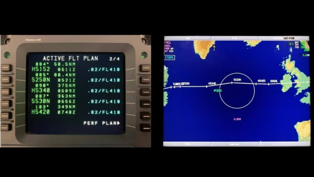
The Honeywell method.
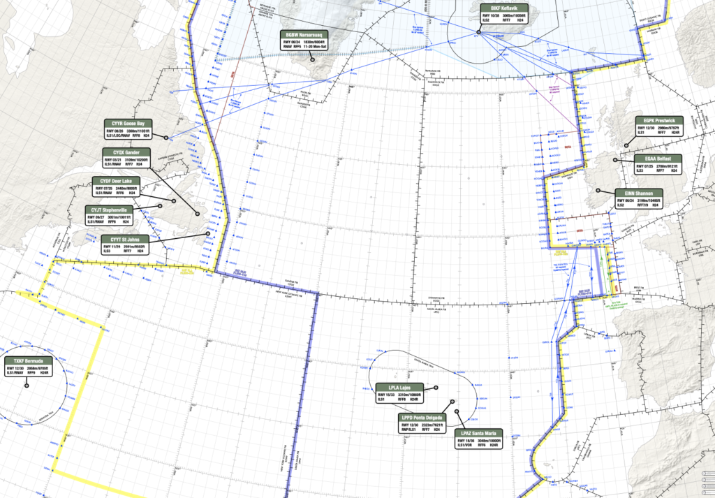
3. Have a little look over the weather and Notams for the en-route alternates in the NAT region.
Places can get nasty in winter, and there aren’t many, so if one of them is under 10 feet of snow or has some hideous Notam then you’re better off knowing before you go so you can make a different plan.
Check the old space weather stuff too because if there are some storms raging up there you might experience some HF blackouts or satellite navigation issues and again, good to know what to expect (and what to do about it) before you’re in it.
In the air (approaching the NAT HLA)
- Make sure you know who you need to Logon to for the clearance, and when to do it.
- Check everything is still working.
- Once you get your clearance make sure both of you check it. That means checking what you’ve been cleared is what you have in the box. If it has changed then you’ll need to do those track and distance checks again. Select North Ref to TRUE for this but don’t forget to set it back to MAG once the checks are done.
- Make sure you have the right Mach set (if it’s a constant mach segment).
- Check the RNP and Nav Accuracy is High.
- Check your altimeters are all within 200’ of each other.
- Brief your contingencies again and think about whacking something in the secondary to help if you want to.
Entering the NAT HLA
In you go…
Put that SLOP in (0/1/2nm RIGHT of track, or 0.1 increments if your airplane is that clever) and select 123.45MHz on VHF1 (unless you still have an active ATC VHF). Keep a good listen on 121.5MHz on VHF2. If you’re heading into HF land then check in and do your SELCAL check.
When you’re 30 minutes in, set your squawk to 2000.
Now, some do this, some don’t, and a lot do it different – it depends whether you’re old school and using a plotting chart, or new school and EFB-ing. But even if you are in a high tech aircraft this is still one good method for checking you don’t get any GNEs:
- As you cross over a waypoint, set your timer.
- After 10 minutes, check your GPS position in your FMS, and plot it on your chart/compare it to where your airplane is showing on your (electronic) map. If it doesn’t match then you’ve got yourself a problem.
Keep an eye on those alternates and their weather. Plan stuff in advance so if anything happens you’re not flailing about in the sky like a headless chicken.
You can use a paper plotting chart, or a digital chart.
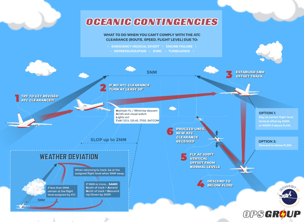
UH OH! I’ve got issues…
Use the contingencies, but not before trying to talk to ATC.
- If it’s a weather thing and you only need up to 5nm to detour around it then maintain your assigned level. If you’re going to need more than 5nm then use SAND – if your turn moves you South then ascend (climb) 300’. If your detour moves you North than descend 300’.
Always check the tracks and traffic proximity first. Turning the direction which will mean a longer detour might keep you more clear of traffic.
- If it’s a serious technical problem then turn 30° and offset laterally by 5nm. Once established, climb or descend 500’ (1000’ if above FL410) or descend all the way down below FL290.
- If it’s a communication issue then stick with your assigned clearance and do what you can to get in touch with someone.
- If it’s an ATC issue (ie they’ve evacuated and aren’t there anymore) then follow the published contingency procedures.
- If it’s some sort of navigation problem then get in touch with ATC and go from there.
Click to download PDF.
I made it!
Congrats. Delete the SLOP, set the speed to what you need and out you go, smug in the knowledge you traversed the NAT HLA without mistakes.
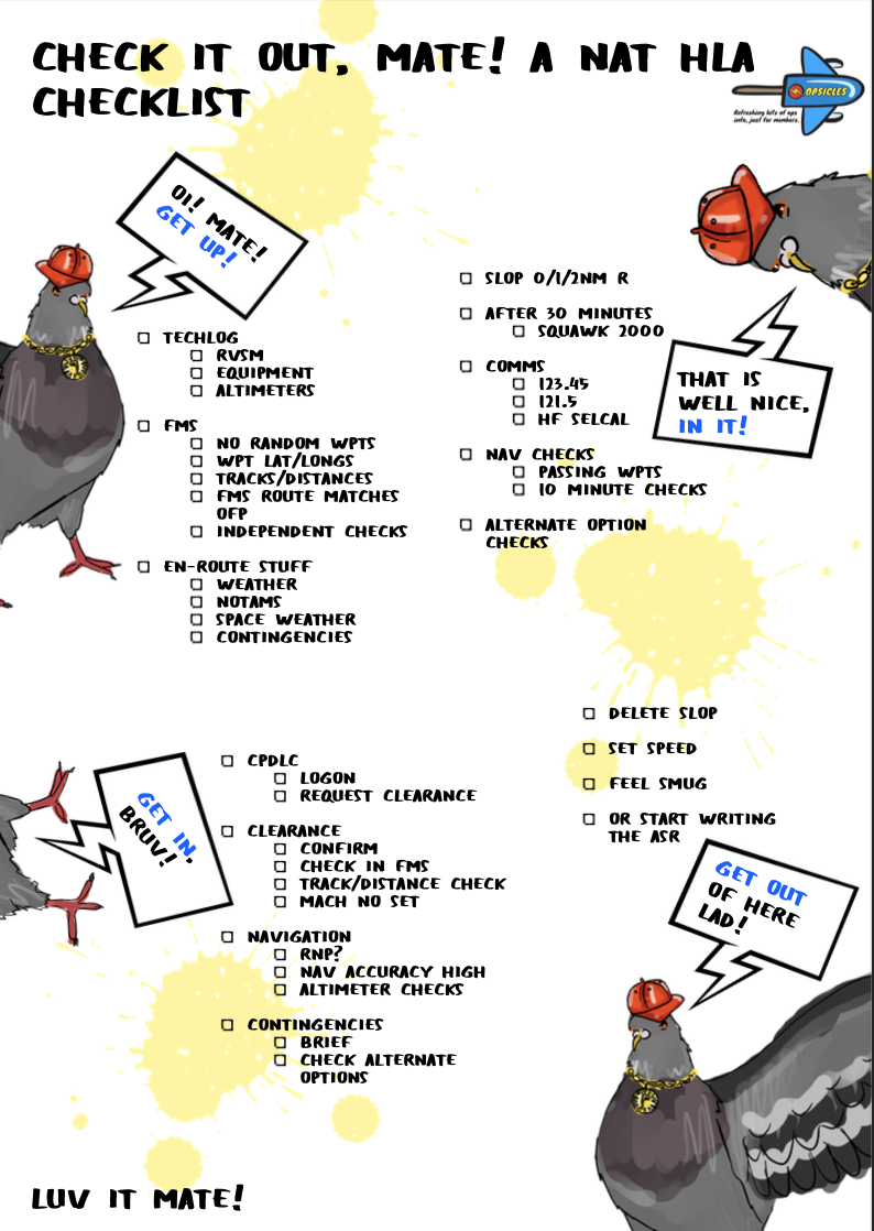
A checklist for you 🙂
We turned all this info into an Opsicle. It has London pigeons in it because they are clearly the masters of crossing the North Atlantic. Grab it here.
More on the topic:
- More: New NAT Doc 007: North Atlantic Changes from March 2026
- More: What’s Changing on the North Atlantic?
- More: Timeline of North Atlantic Changes
- More: Blue Spruce Routes Are Gone (But You Can Still Fly Them)
- More: Updated FAA Oceanic Guides
More reading:
- Latest: Middle East Airspace – Current Operational Picture
- Latest: European VPT Approaches: Not Your Usual Visual
- Latest: EES & ETIAS: The BizAv Guide
- Safe Airspace: Risk Database
- Weekly Ops Bulletin: Subscribe
- Membership plans: Why join OPSGROUP?


Mark is correct. See NAT Doc 007, Page 66, Paragraph 7.4.1
Yip, it’s in there already.
Doesn’t SLOP in NAT HLA now allow 0-2.0nm right in .1 increments?
Unless things have changed, I believe that you are required to maintain your assigned Mach until top of descent, even in domestic airspace, unless cleared by ATC for free speed.
I believe that you fly constant Mach until exiting the oceanic airspace and then adjust speed back to as per your flight plan.
Try this and build on it…
https://www.icao.int/EURNAT/EUR%20and%20NAT%20Documents/NAT%20Documents/NAT%20OPS%20Bulletins/NAT%20OPS%20Bulletin%202017_005Rev01.pdf
Very good resource (that’s where we pulled the info for this post)