Some people really enjoy plotting. If the other pilot has added some tiny krakens or miniature pirate ships to find on the chart, it can be a fun way to pass the time on a dark and endless North Atlantic crossing. For most though it is an irritating thing not made an easier by the somewhat confusing requirements as to how, when and why you need to do it.
So here is a brief summary of the FAA Plotting requirements.
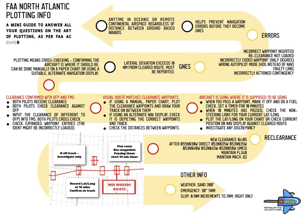
What do the rule books say?
The place to find the info is this – AC 91-70B
It is an advisory circular providing ‘general information and guidance for commercial and General Aviation operators (“you”) planning flights in oceanic and remote continental airspace’.
Sounds good until you actually open and discover it is 114 pages long and the first chunk is a very long list of links to other documents which you also need to refer to for information and guidance. We actually started writing this post in 2019 when the current AC came out…
So, this post is just looking at plotting. That’s it. Just plotting.
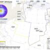
Here is the Opsgroup North Atlantic 2021 chart. Click for info on how to download a copy!
Why do we need to plot?
We plot so that we can check that the airplane is actually going where it should be going, and that we are where we are supposed to be.
The North Atlantic is big and remote and unlike land, there aren’t many places to put Navaids, which means you are relying entirely on your Long Range Navigation Systems (usually something to do with satellites) to ensure you are in the correct place.
The second problem is we make mistakes – sometimes we put the wrong things in the box (see the section on half degree waypoints below). So plotting can help catch those navigation errors before they become really ‘gross’.
The FAA say “you should use a chart, of appropriate scale, to provide yourself with a visual presentation of your intended route, regardless of your type(s) of LRNS.” (6.3.1.11)
And ICAO say… actually they pretty much say the same. (Position Plotting 8.2.10)
When do we need to plot?
The earlier FAA AC 91-70A had a whole section (3.6) on when plotting is required:
- Turbojet aircraft: If you are operating along a route segment where the distance between standards ground based navaids exceeds 725nm
- Turboprop aircraft: ditto ditto 450nm
But – this was removed in the new AC. So, do you still need to plot?
Well, the simple answer is yes, and the more complicated answer is that “plotting” means something a little different now. It isn’t about drawing it on a map so much as checking and cross-checking your position.
Click to download the official FAA chart.
What is the difference between the cross-checking versus plotting?
Acceptable procedures are outlined in section 6.4.8 of AC 91-70B.
We used to plot manually in order to check we were where we were supposed to be. This cross-check hasn’t really changed – we are still cross-checking the FMS and master document (OFP) against the currently effective route clearance to prevent inadvertent deviations from the cleared route. The big difference is you don’t actually have to do it on a paper map anymore (6.4.8.2).
It is also required regardless of the distance from the nearest NAVAID.
So what do we do it on?
Up until 2019, manual plotting was required, but this changed when the FAA realised FMS-driven navigation displays and what-have-you were actually just as accurate
Opspec/MSpec A061 says you can used an electronic flight bag (EFB) for “interactive plotting” instead of a paper chart (6.3.1.11.2) – in other words an alternate “navigation display”, where the alternate means not necessarily a paper plotting chart.
Back to how do we do it…
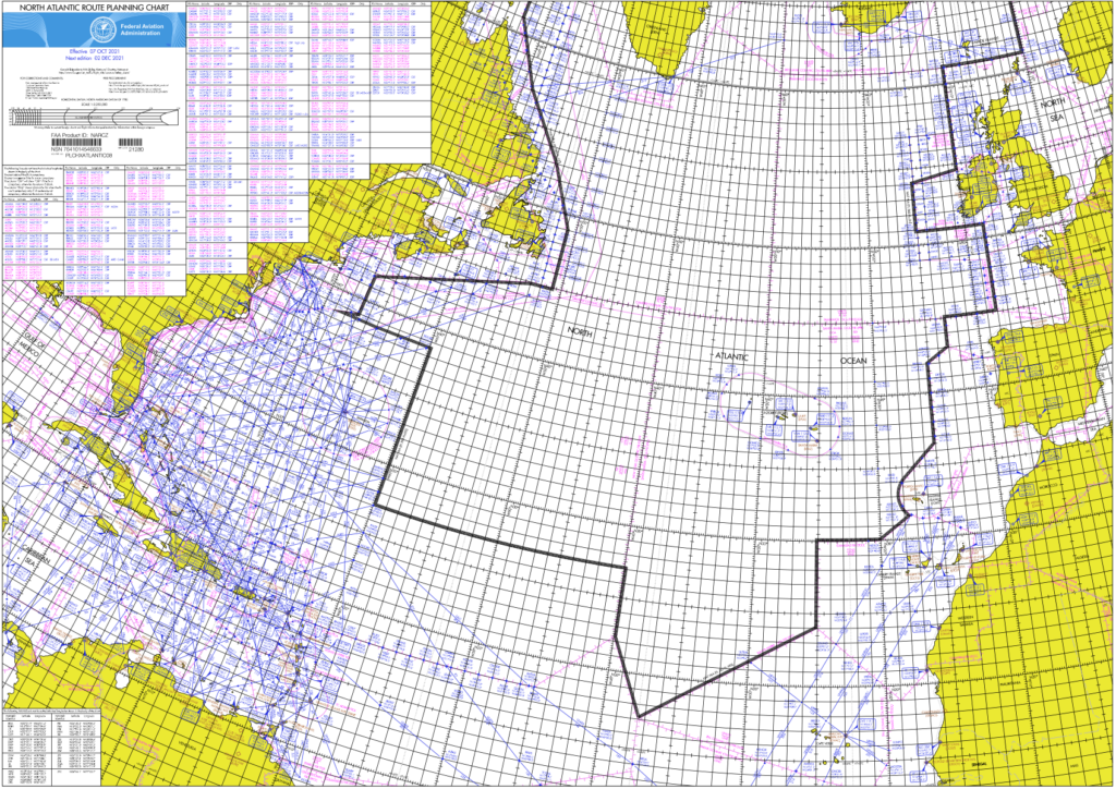
The aircraft position check should be made at a point approximately 10 minutes after a waypoint.
- Plot your current Lat/Long and record the time.
- Use the “non-steering” LRNS to find your current lat/long because if your other one is lost it won’t really help you to use it.
- Confirm the circle/cross/miniature airplane symbol you are using (the nav system is using) to mark your current position agrees with your route clearance. I.e. its on the right track and not out in the middle of anywhere it shouldn’t be.
- Next up, have a look at where you’re heading:
- Check the active leg by confirming the FROM and TO waypoints of the clearance against the active flight plan
- Confirm what is in the FMS matches the clearance
- Check you have the right autopilot mode in. LNAV/NAv is good. HDG is not good
- Check the “expanded” waypoint to make sure there are no rogue minutes in there
- Confirm your ETA over the next waypoint (and check you are the flying the assigned Mach number)
- Check you’re still SLOP-ing if you should be, and at some point, make sure the SLOP ends when it should as well
- Give the wind a quick check as well. It’s just handy to know in case you lose all your LRNS stuff
Just an example, you might do it differently
Re-clearances.
You’ve done all of the above, prepared a beautiful map ready to go and horror of horror ATC send you a new clearance. This is annoying and is the reason most GNE’s seem to occur, or rather folk not doing it right is the reason.
- Confirm the re-clearance with the other pilot. You both have to “receive” it
- Make sure you tell the aircraft the new clearance otherwise it won’t fly where it is supposed to. Both should double check the inputs as well to catch any finger trouble
- Re-plot it ready for your plotting checks
- It can be a good idea to check the new distances between waypoints
- Add in a little fuel check in case it is significantly different to your planned route.
A note on half degrees.
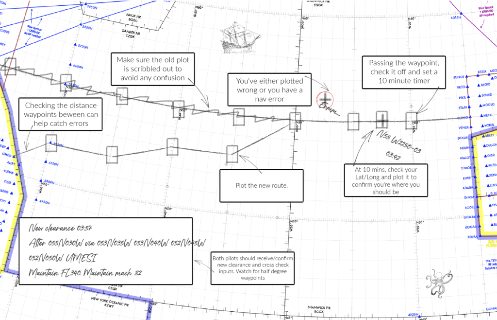
Half degree waypoint are fun little things. “Fun” because they are easy to mess up because no-one ever seems entirely sure how to type it into the aircraft computer.
Here is an ICAO paper on it. Well, actually it is on general waypoint insertion, but with a focus on half degree ones.
The issue tends to be with the identifiers. For example, ARINC 424 uses an “N-prefix” format which means you might see N5250 and be all “that looks like half of north 50” but actually this would mean 52030N 050000W. So you need to potentially check two things here.
- First, if you receive a clearance with a half degree waypoint, confirm the identifier (N5250) has been loaded with the half degree (52030N 050W) like in the picture below
- If you have a clearance with no half degree waypoints and are whacking in pre-loaded Idents, check they don’t have half degrees – because N5250 night not mean N52000 W050000.
The ident doesn’t show the half waypoint – so the full waypoint must be checkedStill confused about what to insert? Read this handy guide from Honeywell.
Watch this space.
The FAA are plotting a new draft – AC 91-70C – which will probably be out towards the end of 2021/ start of 2022.
All done?
We wrote a load of stuff on plotting back in February 2020. Most of it still applies and you can read it here.
We have also made a handy Opsicle (refreshing bits of ops info, just for members). This one is called The FAA North Atlantic Plotting Guide and if you are a member then you can download it here.
Click to download PDF.
More on the topic:
- More: 2026 North Atlantic Plotting & Planning Chart
- More: NAT Guide 2026 – My First NAT Flight is Tomorrow
- More: Timeline of North Atlantic Changes
- More: New NAT Doc 007: North Atlantic Changes from March 2026
- More: What’s Changing on the North Atlantic?
More reading:
- Latest: Gander’s Bringing Back CPDLC Oceanic Reroutes
- Latest: EU Temporary Admission of Aircraft – Busting Myths
- Latest: US Ops Update: Speeds, Squawks and Slippery Runways
- Safe Airspace: Risk Database
- Weekly Ops Bulletin: Subscribe
- Membership plans: Why join OPSGROUP?