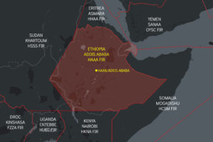
New RISK WARNING: Somalia ATC Conflict

Update Nov 2025: Somalia-Somaliland Airspace and Permit Dispute 

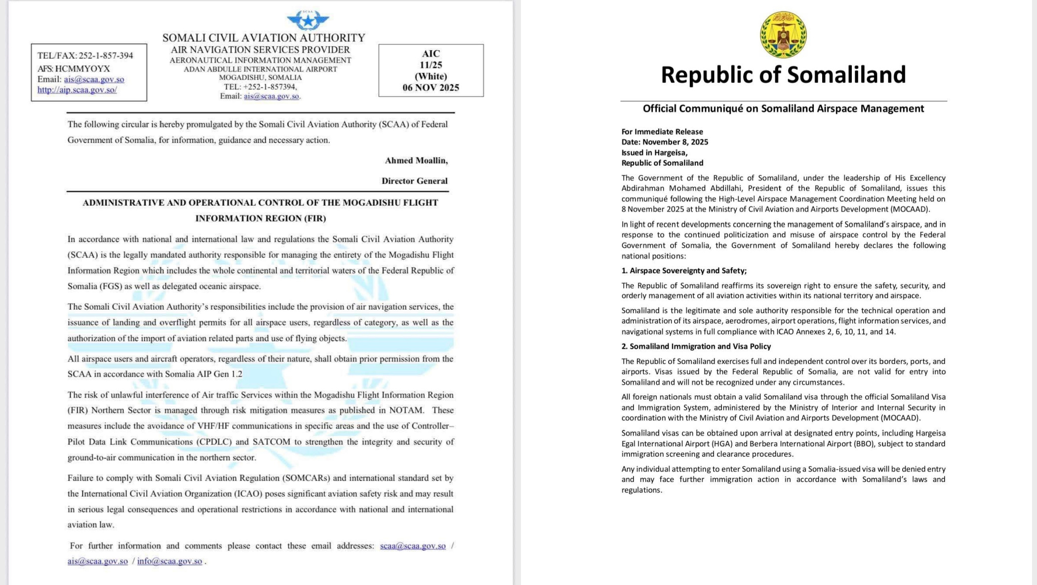
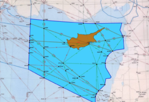
Be aware of an ongoing authority dispute in the north of the HCSM/Mogadishu FIR. Both Somalia and the self-declared state of Somaliland have issued conflicting instructions for overflights. From Nov 10, Somaliland says all flights require PPR from its own CAA, while Somalia has reaffirmed through an AIC that it controls the entire FIR and operators should follow its AIP.

Expect mixed messages on permit requirements near northern Somalia and the Hargeisa region. The Somali CAA remains the only internationally recognised authority for all Class A airspace above FL245 – be cautious of conflicting or unauthorised clearances.

For background on this long-running dispute and its impact on ATC safety, see safeairspace.net.

Ongoing since Feb 2024: ATC Conflict in Somalia

Key information for Flight Crew

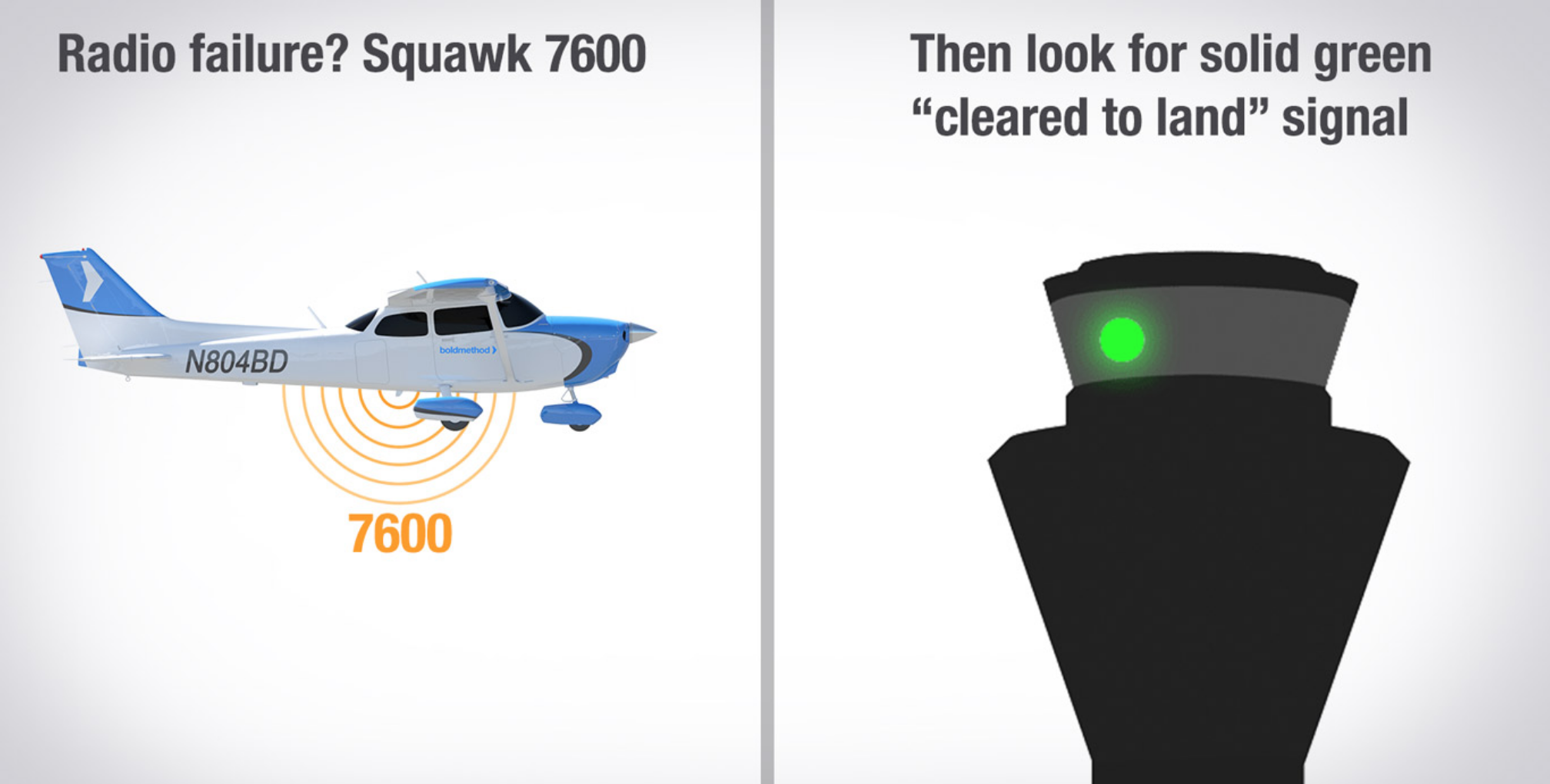
Over the weekend, OPSGROUP has received at least 10 reports of aircraft within the Mogadishu FIR being contacted by a ‘fake controller’ on the same frequency, issuing conflicting instructions.

Crews have been issued climb and descent clearances that are not from the sector controller. Incidents have been reported mostly in the northern part of Mogadishu airspace.

The situation emanates from a political dispute between Somaliland and Somalia, two different countries, though the former does not have international recognition. Both countries now claim authority over the Mogadishu FIR.  

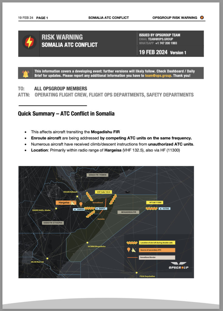
Quick Summary – ATC Conflict in Somalia

  • This affects aircraft transiting the Mogadishu FIR
  • Enroute aircraft are being addressed by competing ATC units on the same frequency.
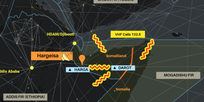
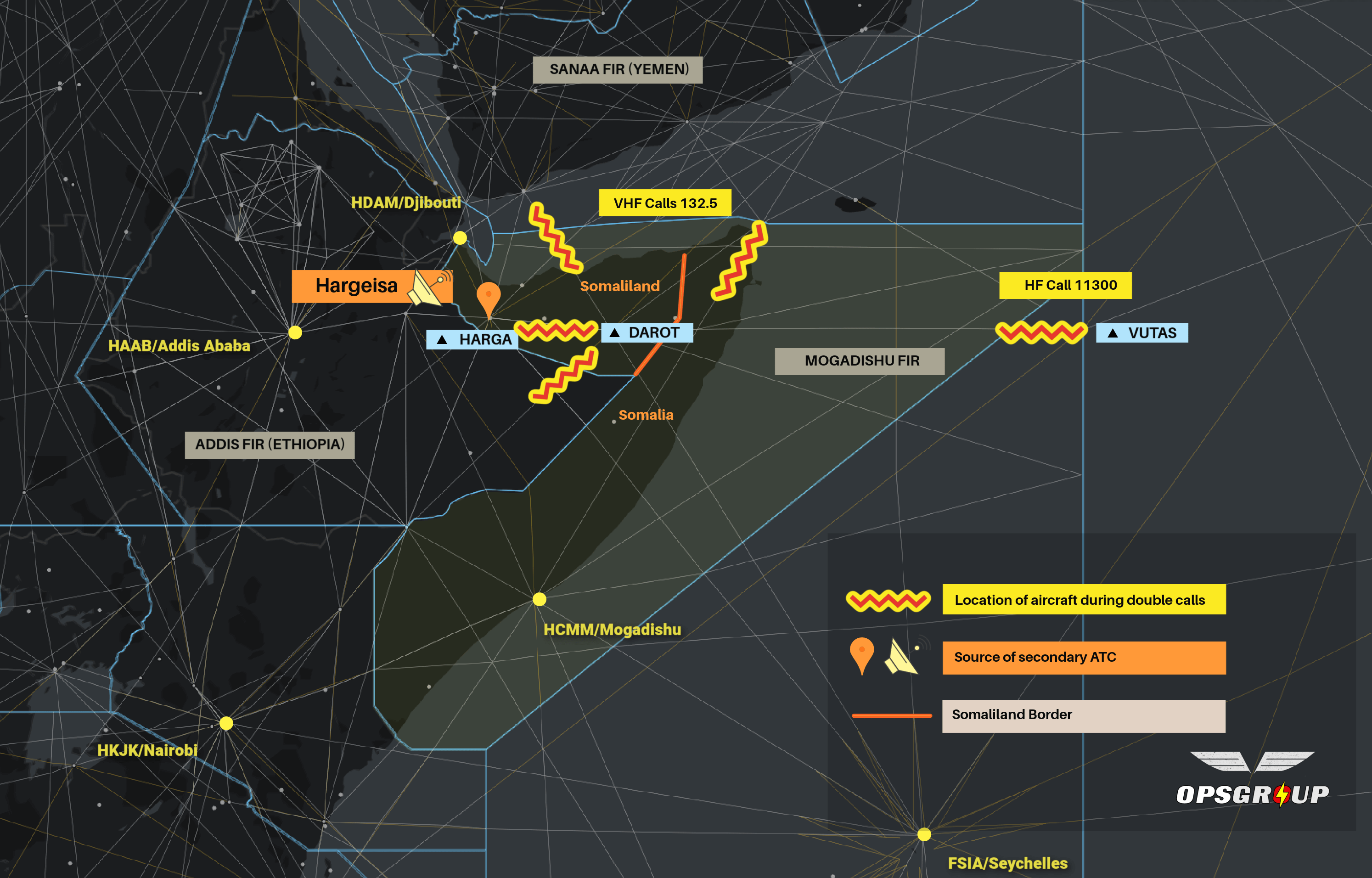
  • Numerous aircraft have received climb/descent instructions from unauthorized ATC units.
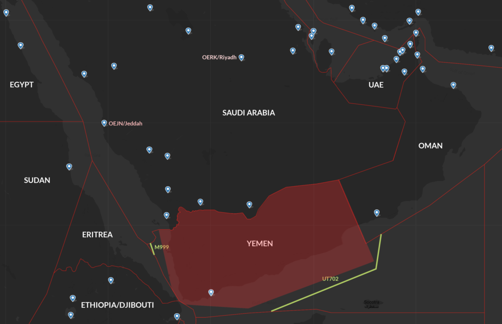
  • Location: Primarily within radio range of Hargeisa (VHF 132.5), also via HF (11300)

OPSGROUP Members

In your Dashboard you’ll find the full Risk Warning, including Crew Reports, Maps, Analysis, and Guidance. If you can’t access, just email the team and we’ll send you a copy.

Download the Risk Warning (PDF, 9 pages, 2Mb) 

Analysis

(Excerpt from the Risk Warning in your dashboard)

The background to the situation is an escalating political dispute between Somaliland and Somalia. Somaliland has been an independent country since 1991, but without international recognition. Somaliland has to date maintained control over its airports, but Somalia controls the upper airspace from Mogadishu.

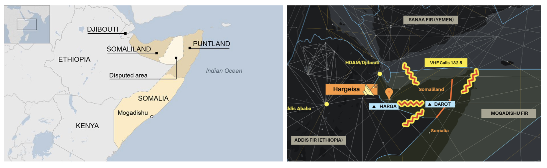
In January 2024, Ethiopia signed an agreement with Somaliland, essentially exchanging port rights on the Red Sea for recognition of their country. This was met with condemnation by Somalia. Somalia, in response, began restricting movements into Somaliland by way of denying airspace entry to the Mogadishu FIR in some instances. This has led to Somaliland declaring its right to exercise control over their airspace.

The net result is an airspace dispute between the two territories. Both Somalia and Somaliland now claim the right to control traffic. This is why crews have been contacted by other “controllers” on 132.5 (VHF) and 11300 (HF). Although it is likely that these other “controllers” are genuine Air Traffic Controllers, they are operating outside their area of jurisdiction as things stand.

Currently, the authority over the entire Mogadishu FIR is Mogadishu Control. They remain the sole authority to control, coordinate, and provide ATS services in the Upper FIR. The secondary transmissions are coming from Hargeisa in Somaliland. Although the motive for these transmissions can be understood, they present clear danger to enroute traffic. The transmissions appear to attempt to mimic Mogadishu rather than present as “Hargeisa Control”, “Somaliland Control”, or any clear differentiator from Mogadishu.

It would also appear from the reports that we have received, that the control instructions are not being issued to de-conflict traffic, but rather to create confusion. This may be an effort to draw attention to the airspace issue, but could have tragic consequences. For flight crews, we follow with some guidance to mitigate the situation.

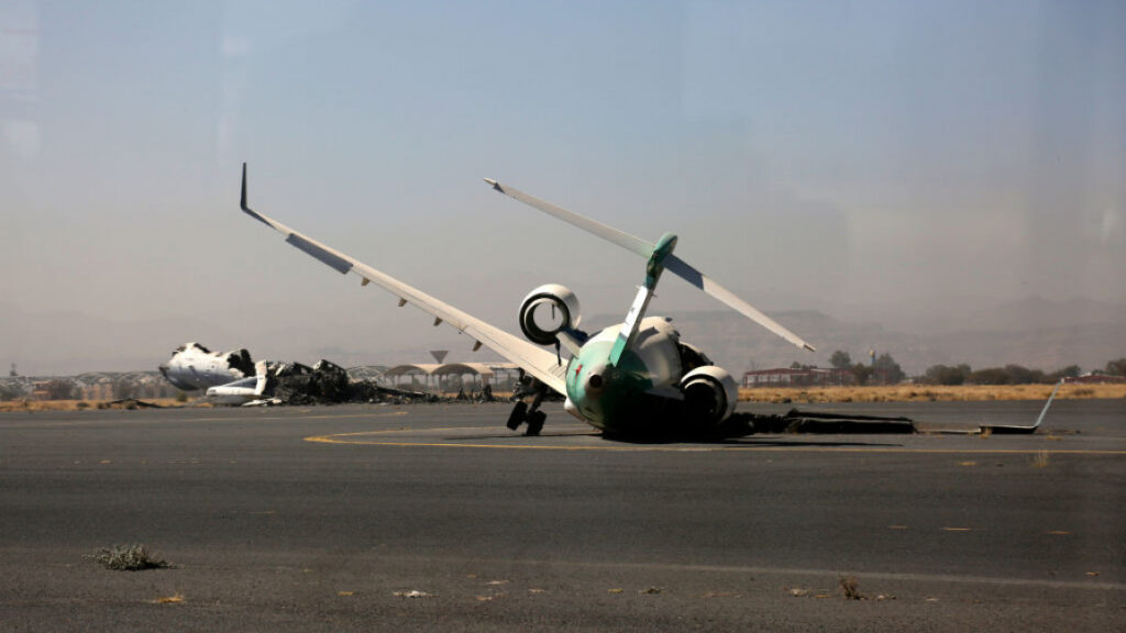
The situation is volatile and may escalate. On Sunday, February 18, an AIS Officer from Somaliland, working in Mogadishu, was found dead at his home. His death appears related to this situation.

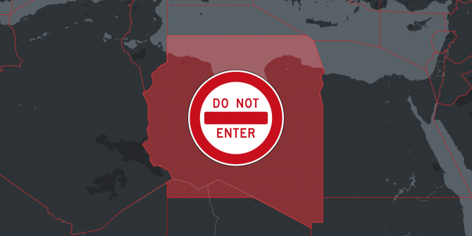
Avoidance of Mogadishu airspace would provide ultimate safety, and if the situation continues, would be wise.

[Excerpt, see full Risk Warning for crew reports received, maps, guidance] 


Saudi-Yemen Airspace Update

There’s an improving airspace risk picture in Saudi Arabia since a ceasefire was agreed in April – which has now been extended to Aug 2. All groups have agreed to halt the conflict inside and outside Yemeni borders. The first month of the ceasefire saw no reported drone strikes in Saudi Arabia.

However, long-standing airspace warnings remain in place. If the conflict resumes, Houthi drone and missile attacks on targets in Saudi Arabia pose a potential threat to ops at Saudi airports, and for overflights of the OEJD/Jeddah FIR. The most significant risk is in the south of the country along the border with Yemen, but OERK/Riyadh and OEJN/Jeddah airports have also been targeted in the past.

Back in March 2021, OEJN/Jeddah Airport closed temporarily following multiple attempted drone attacks. Saudi media reported dozens of drones were intercepted in their airspace, and the US Embassy also issued a statementOERK/Riyadh Airport was targeted in June 2020 and again in October.

Much of the information comes from state media and cannot always be independently verified. In 2017, a New York Times investigation suggested that at least one of the most high-profile attacks from that year may not have been “shot-down” or intercepted by Saudi defense systems at all.


Saudi Arabia Airspace Risk

With the ceasefire now in place, we’re waiting to see if any of the countries who have issued airspace warnings for Saudi Arabia will amend their guidance.

Germany and Canada warn of a risk to landing anywhere in the country, but particularly along the border with Yemen in the southwest part of the OEJD/Jeddah FIR. France has issued similar advice, with the specific warning not to operate to OEAB/Abha, OEGN/Jazan, OENG/Nejran, OESH/Sharurah, OEWD/Wadi Al Dawasir and OEBH/Bisha airports:

A note on Yemen

The first month of the ceasefire saw notably reduced hostilities in Yemen, and commercial flights resumed at OYSN/Sanaa Airport for the first in six years.

However, Yemen remains an active conflict zone, and the vast majority of Yemeni airspace (OYSC/Sanaa FIR) should be avoided. Several countries have prohibited flights here due to the ongoing conflict on the ground. The oceanic portion of the OYSC/Sanaa FIR is excluded from most warnings, by nature of being offshore. The guidance issued by the US FAA currently looks like this:

Essentially, US operators are banned from flying north of a line KAPET-NODMA-ORBAT-PAKER-PARIM-RIBOK. The US FAA specifically mentions UT702 and M999 as being ok to use.

Watch out for ESCAT

You might know this as SCATANA. ESCAT is the new name, but the process is the same – if you’re overflying the OEJD/Jeddah FIR and hear “ESCAT RULES ARE NOW ACTIVE” (or something to that effect) you need to be aware that these apply to you!

You will likely be given a change of route directly out of the airspace, or will be directed to land at the nearest suitable aerodrome. The purpose is to clear the affected airspace of all civilian aircraft at which point they close down all nav aids and airports until the threat has been dealt with.

ESCAT procedures are published in GEN 1.6 of Saudi Arabia’s AIP. If you don’t have a login, you can see the relevant section here. There are some special routes that you have to fly in the southern part of the OEJN/Jeddah FIR, as advised by Notam, and you can find these in AIP SUP 02/21.

SafeAirspace.net continues to provide up-to-date information for both Saudi and Yemen airspace.


Navigating the AKARA Corridor

Some big improvements are on the way for the AKARA Corridor – a piece of airspace 100nm off the coast of Shanghai that connects China and Japan.

In effect the airspace is being simplified. Currently, South Korea’s Incheon ACC controls North/South routes, while Japan’s Fukuoka ACC controls East/West. The two operate on different frequencies – a cause for concern for emergency descents while heavy aircraft out of ZPSD/Shanghai are often penalised with inefficient levels.

This area has always been unusual in that more than one center has had responsibility for controlling aircraft at different waypoints.

But on 11 Jan, 2021, ATC authorities in Japan, China and South Korea agreed to implement a proposal from ICAO regarding ATC management in this area – so from 25 March 2021, South Korea will control all flights in this area.

There will also be a new East/West route in addition to airway A593 to further improve efficiency. You can read all about the changes in more detail here.


Airspace Risk Warning – Ethiopia and Eritrea

There is a new Conflict Zone in the east of Africa, which carries elevated risk to flight operations that may not be obvious from NOTAMs or other risk warning sources.

Some airways have been closed by the Ethiopian and Sudanese CAAs. Other airways that are still open are very close to the Conflict Zone. These are frequently used by international operators on the Europe- East Africa route. In particular: UN321, UG300 and UL432. We are concerned that operators may be using these routes without being aware of the risk.

OPSGROUP has today issued an Airspace Risk Warning to its members.

Download OPSGROUP Airspace Risk Warning – Ethiopia/Eritrea (PDF)


Download Hi-Res version of this Conflict Zone map


Situation

The region being disputed is called Tigray. It’s in the north of Ethiopia. Government forces are fighting a regional force that wants independence, called the TPLF. In the past week, there has been heavy fighting, multiple airstrikes, missiles launched, and a growing refugee crisis. A domestic conflict has become a cross-border war.

Our Concerns

There are many warning flags that point to previous shootdown incidents – not least MH17 and PS752. These are the reasons we are particularly concerned about the risk to civil aviation in this region:

Local NOTAMs are misleading
The NOTAMs issued by the Ethiopian CAA to close airways in the conflict zone (UM308, UT124) do not say why they are closed. NOTAMs issued to reroute traffic to adjacent routes (UN321, UL432) do not say why they are rerouted. The same applies to NOTAMs issued by the Sudan CAA to close airways and reroute traffic. Flight crews and aircraft operators are therefore not alerted to any conflict in the area by NOTAM.

Arbitrary Reroutes
Traffic is being rerouted to other airways by ATC, but it’s not clear, or likely, that there has been any risk assessment. European flights are now using UN321/UG300, and UL432 – all of which come exceptionally close to the conflict zone. As we’ve learned from MH17 and PS752, just because airspace is open and available, does not mean it is safe.

Previous shootdowns
The Ethiopian Army shot down an Embraer 120 in May 2020, in Somalia. The Ethiopian Air Force shot down a US Learjet in August 1999 in the Eritrean border region. Both were misidentified.

No guidance to operators
No aviation authorities or official sources have issued any guidance or warnings to date via normal channels.

Rapid Escalation of Conflict
The situation has intensified rapidly, and is extremely unpredictable and unstable. The impact on aviation has not been widely reported.

Guidance

Enroute – Overflight:
If you’re transiting any airspace near or over Ethiopia, Eritrea, or Sudan, take a close look at the map and cross check the airways you are operating on. Several open airways are exceptionally close to the Conflict Zone. Just because they are open does not mean they are safe.

Landing – Airports:
Airports in the north of Ethiopia, including the Tigray and Amhara regions, are unsafe at present. Many are closed. There have been missile attacks on HABD/Bahir Dar, and HAGN/Gondar. HHAS/Asmara in Eritrea should be avoided – missile attack on Nov 14, 2020.

Information Sources

The Conflict Zone & Risk Database at SafeAirspace.net contains all current published warnings and alerts for Ethiopia and Eritrea.

The countries that issue the most relevant updates for unsafe airspace are:

• US (FAA) – through Notams and SFARs
• UK (DFT) – by Notam and then AIP
• Germany (BMVI) – by Notam
• France (DGAC) – by AIC

Note: Operators should not rely on EASA Conflict Zone Information Bulletins (CZIB)’s as a primary source of information. These serve only as pointers to the above sources, and often are not issued until several months after updates, if at all. Note that the Civil Aviation Authorities of the countries whose airspace is determined to be unsafe are unlikely to issue reliable guidance.

Group effort

This information is compiled from OPSGROUP member input, information, intelligence and analysis. If you have additional information to share, please send it to report@safeairspace.net.

Members: More information

OPSGROUP Members: More information in the discussion in the Forum about Ethiopia/Eritrea:
Forum > International Ops > New Conflict Zone Ethiopia/Eritrea

All links to further resources are there.


Bamako Airport reopens following military coup

Bamako Airport has reopened following last week’s military coup which overthrew the government, though monitor GOOO/Dakar FIR and GABS/Bamako Airport Notams for further – it may change.

The Bamako TMA (which sits under the GOOO/Dakar FIR) remains operational with overflights unaffected.

ICAO is actively monitoring and ensuring that there is a timely flow of information on continued airspace/ATC service availability. MedAire have given us a local situation update: with the continuing uncertainty they recommend against overnights until things settle. There is likely to be a high demand for emergency/evac flights in the coming days, and they recommend those to be quick in and outs for now.

Meanwhile, the Northern Mali conflict continues, and there have been no improvements in stability. The US, Germany, France and the UK all have airspace warnings in place, advising to operate FL250/260 or higher, and avoiding GATB, GAGO, and GAKL airports. We would suggest, as usual, that a higher level closer to FL300 is more sensible.

Senegal and Niger control the airspace over Mali, and they have long-standing Notams (published under the GOOO/Dakar and DRRR/Niamey FIRs) warning that you can only fly between FL320-400 through the entire airspace in Mali north of the GABS/Bamako TMA due to military ops across the region. Here’s what that looks like:

The UK recommend against all travel to northern Mali, and against all but essential travel to the south of the country, including Bamako. The US advice is more straight-forward: do not travel to Mali due to COVID-19, crime, terrorism, and kidnapping.

For more info on operating in this region, check out SafeAirspace.net


Risk assessing Iran ops – the UIA 737 may have been shot down

Special Update Thursday 09JAN: Members, please see either your email or this post in the Members forum, for a special briefing and update.

08JAN: Iran/Iraq Information page activated with latest information.

The cause of the crash of Ukraine International Airlines (UIA) AUI/PS752 on departure from Tehran is not yet determined, and given political circumstances, may not be clarified beyond reasonable doubt anytime soon.

Purely from the perspective of making a risk assessment for operations to Tehran, and Iran in general, however, we would recommend the starting assumption to be that this was a shootdown event, similar to MH17 – until there is clear evidence to the contrary.

Images seen by OPSGROUP, shown below, show obvious projectile holes in the fuselage and a wing section. Whether that projectile was an engine part, or a missile fragment is still conjecture, but in making a decision as to whether to operate to Iran, erring on the side of caution would dictate that you do not, until there is clear information as to the cause.

Obviously, there is also the wider regional risk as indicated through the US FAA Notams issued late Tuesday night. US operators are covered by these clear and specific Notams – do not operate to Iran, or Iraq, or operate in the Persian/Oman Gulf area.

Other operators are free to make their own judgement, but should note that a majority of non-US international carriers have elected to avoid both countries for the time being.

See also:

  • OPSGROUP Article: FAA Bans Flights Over Iraq And Iran Following Missile Strike On US Base
  • OPSGROUP Article: Germany publishes new concerns for Iraq overflights


Images from ISNA, Reuters; marking of projectile areas from JACDEC.


Germany publishes new concerns for Iraq overflights

Late Monday evening, the German LBA published a new warning for Iraq, indicating areas of concern for overflying traffic, together with a new warning on ORBI/Baghdad Airport.

Notam B0007 of 2020 (issued Jan 6) replaces Notam 0002 (issued on Jan 2nd), and these are the routes that Germany now considers a potential risk for aircraft below FL260:

Airway UM860 NAMDI – NINVA
Airway UM688 RATVO – SOBIL
Airway L718 TAGRU – KABAN
Airway L417 MUTAG – VUSEB
Airway M434 UMESA – BOXIX
Airway R652 MUTAG – DAVAS

Seen on the map below, all these airways are in the north east of Iraq: the yellow lines are the warnings that existed on and prior to Jan 2nd, and the orange lines show the additional areas flagged in Mondays Notam.

Of the other primary states that issue airspace warnings – the UK, France, and the US – none have issued updated guidance yet this year.

There is no doubt that the events of Jan 3, 2019 at ORBI/Baghdad Airport have created an extremely tense situation between the US and Iran. The aviation security picture in the Middle East, already fragile and unstable, is now unpredictable. A response by Iran to the US airstrike of Jan 3rd seems possible.

Specific to the Baghdad Airport incident, it seems early reports of Katyusha rockets can be discounted, that it was an attack carried out on vehicles near the airport by US Apache Helicopters. Civil traffic resumed operations shortly after the attack with several departures operating ‘as normal’. Overflights continued during the attack.

As to the Iranian response, anything that looks like a US asset or ally could be a target – military or civil. US operators, at a minimum, should be avoiding the Tehran FIR, and considering security carefully when operating in other countries in the region, most notably Israel, Lebanon, and Kuwait – as a response may target airports in those countries or foreign aircraft. That said, it’s a guessing game right now, and predicting the specifics of a response is extremely difficult.

For full analysis, and a listing of all current warnings, see Safe Airspace.


Libya Airspace Update Oct 2019

On 23rd Oct 2019, the US issued an emergency order prohibiting U.S. operators from flying in Libyan airspace. The guidance here is very clear: do not operate anywhere in the HLLL/Tripoli FIR, at any flight level.

This follows months of civil war in Libya, with militia from the east mounting a campaign to seize control of Tripoli, including HLLM airport, and threatening to shoot down aircraft operating in western Libya.

In recent months there have been a number of airstrikes targeting HLLM/Mitiga airport, the latest coming on Aug 15, which reportedly killed two people and forced the airport to close. There are videos on social media showing planes landing at the airport as shells are falling in the background.

Prior to yesterday’s announcement, the U.S. guidance on Libya was that operators were allowed to overfly Libya at FL300 or above, except an area in the north-western part of the country over Tripoli, where all flights were prohibited. Here’s what that looked like:

But this guidance is now defunct. The FAA website now shows the updated guidance for Libya – including the Background Notice.

Germany and Malta still have warnings in place which mirror the old advice of the U.S. – do not fly over the north-western part of Libya, but overflights of the rest of the country are permitted at the higher flight levels. The UK and France advise against all overflights. These warnings may be updated in the coming days, following the new advice from the U.S.

Libya remains politically unstable, with a fragile security situation across the country. In their SFAR issued back in March 2019, the U.S. said that the main threat to aviation at the lower flight levels stems from the widespread proliferation of man-portable air-defence systems (MANPADS) across the country:

“Both GNA and advancing LNA forces have access to advanced man portable air defense systems (MANPADS) and likely anti-aircraft artillery. These ground-based weapon systems present a risk to aircraft, but only at altitudes below FL300. LNA forces have tactical aircraft capable of intercepting aircraft at altitudes at and above FL300 within the self-declared military zone in Western Libya, which may present an inadvertent risk to civil aviation operations in Western Libya. While the LNA tactical aircraft threat is likely intended for GNA military aircraft, an inadvertent risk remains for civil aviation at all altitudes due to potential miscalculation or misidentification.”

However, there are factions on the ground in Libya which possess weapons capable of targeting aircraft above FL300. The LNA is one of many armed groups in Libya which continues to use various rocket systems looted from Gaddafi’s stockpiles at the end of the war in 2011. In May 2018, the LNA proudly displayed a refurbished Russian-made surface-to-air missile system at HLLB/Benina Airbase in Benghazi. This system has the capability to engage aircraft at altitudes up to FL450.

The opposing GNA forces have surface-to-air missile systems of their own. Some reports indicate that the GNA are in possession of the Russian-made SA-3 system, which has the capability to engage aircraft at altitudes over FL800.

With the current conflict between these and other rival factions on the ground in Libya now escalating, it’s not clear what level of control the main players hold over their missile systems.

Bottom line, there’s still a potential risk to aircraft at all altitudes and across all parts of Libya.

Even if you are allowed to overfly the country, there are only two approved routes available, in the far north-eastern corner of the country, as per HLLL Libyan Notam A0063/17:

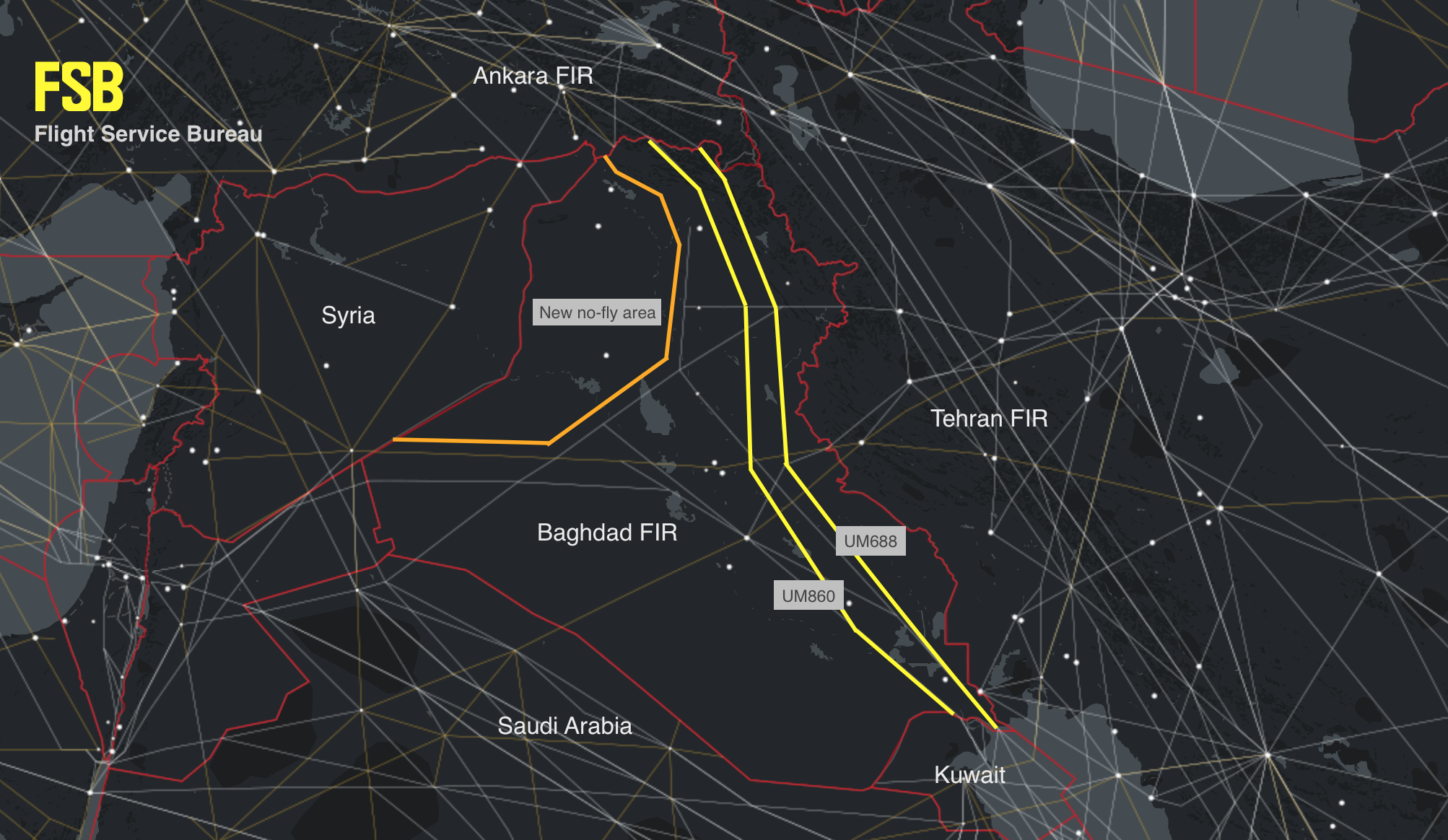
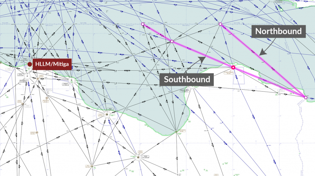
Northbound: LOSUL UP128 LAB UM979 RAMLI UZ270 OLMAX (even levels)
Southbound: RASNO UY751 LOSUL (odd levels)

Even on these routes, reliable ATC services cannot be guaranteed. The past few years have seen regular ATS and radar outages across the HLLL FIR airspace, and severe limitations in VHF capability, with operators having to communicate with Malta ATC for guidance.

Given the current security concerns, we continue to list the entire country as “Level 1 – Avoid” at SafeAirspace.net


US issues Emergency Order – No Fly Zone for Civil Aircraft – Iran

The FAA has issued an Emergency Order to US Civil Aircraft, prohibiting all American aircraft operators from entering the Tehran Flight Information Region (OIIX) FIR in the area above the Persian Gulf and Gulf of Oman.

Notam A0019/19 was issued at 0148 UTC, June 21st.

The Notam specifically prohibits any airline or aircraft operator from flying within Iranian airspace in the region that the US drone was shot down in on June 20th.

Some airlines had already reported suspending operations in Iranian airspace. This Notam ensures that US operators cannot operate in the area. Although the official applicability is to US aircraft only, since MH17 all countries rely on advice from the US, the UK, France and Germany to highlight airspace risk.

The full Notam follows (bolded parts by OPSGROUP):
A0019/19 NOTAMN Q) KICZ/QRDLP/IV/NBO/AE/000/999/
A) KICZ PART 1 OF 2
B) 1906210148
C) PERM
E) SECURITY..UNITED STATES OF AMERICA PROHIBITION AGAINST CERTAIN FLIGHTS IN THE OVERWATER AREA OF THE TEHRAN FLIGHT INFORMATION REGION (FIR) (OIIX) ABOVE THE PERSIAN GULF AND GULF OF OMAN ONLY.


ALL FLIGHT OPERATIONS IN THE OVERWATER AREA OF THE TEHRAN FLIGHT INFORMATION REGION (FIR) (OIIX) ABOVE THE PERSIAN GULF AND GULF OF OMAN ONLY ARE PROHIBITED UNTIL FURTHER NOTICE DUE TO HEIGHTENED MILITARY ACTIVITIES AND INCREASED POLITICAL TENSIONS IN THE REGION, WHICH PRESENT AN INADVERTENT RISK TO U.S. CIVIL AVIATION OPERATIONS AND POTENTIAL FOR MISCALCULATION OR MIS-IDENTIFICATION.THE RISK TO U.S. CIVIL AVIATION IS DEMONSTRATED BY THE IRANIAN SURFACE-TO-AIR MISSILE SHOOT DOWN OF A U.S. UNMANNED AIRCRAFT SYSTEM ON 19 JUNE 2019 WHILE IT WAS OPERATING IN THE VICINITY OF CIVIL AIR ROUTES ABOVE THE GULF OF OMAN.


A. APPLICABILITY. THIS NOTAM APPLIES TO: ALL U.S. AIR CARRIERS AND COMMERCIAL OPERATORS; ALL PERSONS EXERCISING THE PRIVILEGES OF AN AIRMAN CERTIFICATE ISSUED BY THE FAA, EXCEPT SUCH PERSONS OPERATING U.S.-REGISTERED AIRCRAFT FOR A FOREIGN AIR CARRIER; AND ALL OPERATORS OF AIRCRAFT REGISTERED IN THE UNITED STATES, EXCEPT WHERE THE OPERATOR OF SUCH AIRCRAFT IS A FOREIGN AIR CARRIER.


B. PERMITTED OPERATIONS. THIS NOTAM DOES NOT PROHIBIT PERSONS DESCRIBED IN PARAGRAPH A (APPLICABILITY) FROM CONDUCTING FLIGHT OPERATIONS IN THE ABOVE NAMED AREA WHEN SUCH OPERATIONS ARE AUTHORIZED EITHER BY ANOTHER AGENCY OF THE UNITED STATES GOVERNMENT WITH THE APPROVAL OF THE FAA OR BY A DEVIATION, EXEMPTION, OR OTHER AUTHORIZATION ISSUED BY THE FAA ADMINISTRATOR. OPERATORS MUST CALL THE FAA WASHINGTON OPERATIONS CENTER AT 202-267-3333 TO INITIATE COORDINATION FOR FAA AUTHORIZATION TO CONDUCT OPERATIONS.


C. EMERGENCY SITUATIONS. IN AN EMERGENCY THAT REQUIRES IMMEDIATE DECISION AND ACTION FOR THE SAFETY OF THE FLIGHT, THE PILOT IN COMMAND OF AN AIRCRAFT MAY DEVIATE FROM THIS NOTAM TO THE EXTENT REQUIRED BY THAT EMERGENCY.
THIS NOTAM IS AN EMERGENCY ORDER ISSUED UNDER 49 USC 40113(A) AND 46105(C). ADDITIONAL INFORMATION IS PROVIDED AT: HTTPS://WWW.FAA.GOV/AIR_TRAFFIC/PUBLICATIONS/US_RESTRICTIONS/

Earlier today, we published an article summarizing the risk to Aircraft Operators in the Gulf region – “The Threat of a Civil Aircraft Shootdown in Southern Iran is Real


In addition to the Notam, the FAA Threat Analysis Division have also published background information on the current situation (download that PDF here )


In that document, the FAA says: “Although the exact location of the attack is not yet available, there were numerous civil aviation aircraft operating in the area at the time of the intercept. According to flight tracking applications, the nearest civil aircraft was operating within approximately 45nm of the Global Hawk when it was targeted by the Iranian SAM. FAA remains concerned about the escalation of tension and military activity within close proximity to high volume civil air routes and the Iran’s willingness to use long-range SAMs in international airspace with little to no warning. As a result, there is concern about the potential for misidentification or miscalculation which could result in the inadvertent targeting of civil aviation.”

The Iran risk is being monitored at Safe Airspace – the Conflict Zone & Risk Database. The Iran country page also has more information on further overflight considerations in other parts of the Tehran FIR.


The Threat Of A Civil Aircraft Shootdown In Iran Is Real

As we know by now, at 23:35Z last night (June 19, UTC), Iran shot down a US UAV on a high-altitude recon mission in the Straits of Hormuz. This was no small incident. The UAV was a $200 million aircraft, weighing 32,000 lbs, with the same wingspan as a 737.

Although Iran and the US have slightly different versions of the position of the shooting down in the media, the approximate area is very clear, and marked on the map below, which shows the airspace picture at 2335Z, the time of the shootdown.

A high-res version of this map is available here.

For civil operators, the Straits of Hormuz have always been an area of high military activity, so it’s tempting to mark this as ‘more of the same’.  However, over the last few weeks tension between the US and Iran has heightened, and the launching of a surface to air missile by Iran represents an escalation in the current situation that crosses a threshold –  warranting a very close inspection by airlines and aircraft operators overflying, or using airports like Dubai, Abu Dhabi, Ras Al Khaimah, Muscat, and Fujairah.

As we approach five years since MH17, we should remember the build up to that shootdown took several months, and there are the warning signs here that we must pay close attention to. In the lead up to MH17, 16 military aircraft were shot down before MH17 became the 17th. Look closely at the map. Civil aircraft were very close to the site of this incident.

This morning, we sent this out to our members in OPSGROUP:

OIZZ/Iran Earlier today, a large US military drone was shot down by Iran over the Strait of Hormuz. The US say it was over international waters, Iran say it was within their FIR. Either way, it means that SAM missiles are now being fired in the area, and that represents an escalation in risk. It appears a 787 was very close to the missile site this morning. Avoiding the Strait of Hormuz area is recommended – misidentification of aircraft is possible. If you are coming close to Iran’s FIR, it’s essential that you monitor 121.5, as Iran uses this to contact potentially infringing aircraft. Local advice from OPSGROUP members says ‘Even if the operator/pilots think they will come close or penetrate Irans Airspace they should contact Iran Air Defense on 127.8 or 135.1’. If the Iranians have an unidentified aircraft on their radar and not in contact with them they will transmit on guard with the unidentified aircraft coordinates, altitude, squawk (if there is one), direction of travel and then ask this aircraft to identify themselves as they are approaching Iranian ADIZ. Monitor safeairspace.net/iran for the latest. 

Last September, when Syria shot down a Russian transport aircraft, we published an article on that risk, and noted “50 miles away from where the Russian aircraft plunged into the sea on Monday night is the international airway UL620, busy with all the big name airline traffic heading for Beirut and Tel Aviv. If Syria can mistakenly shoot down a Russian ally aircraft, they can also take out your A320 as you cruise past.” That same risk of misidentification exists here in the Straits of Hormuz.

Apart from the misidentification risk, is the risk of a problem with the missile itself. The missile used by Syria in September was a Russian S-200 SAM, which was the same missile type that brought down Siberian Airlines Flight 1812 in 2001. The missile can lock on to the wrong target, and this risk is higher over water. The missile system used by Iran last night was a domestically-built Raad Anti-Aircraft system, similar to the Russian Buk that was used against MH17. Any error in that system could cause it to find another target nearby – another reason not to be anywhere near this part of the Straits of Hormuz.

Bear in mind that as an aircraft operator you won’t be getting any guidance from the Civil Aviation Authorities in the region. As we saw with Syria, even when an aircraft had been shot down on their FIR boundary, the only Notams from Cyprus were about firework displays at the local hotels. It won’t be any different here. You need to be the one to decide to avoid the area.

A further risk, if you needed one, is retaliation by the US. It seems probable that the US will at least try to find an Iranian target to make an example of. If you recall the Iran Air 665 tragedy, back in July 1988, which occurred in the same area, the US mistakenly shot down that aircraft thinking it was an Iranian F-14.

Bottom line: we should not be flying passenger aircraft anywhere near warzones. That’s the lesson from MH17, and that’s the lesson we need to keep applying when risks like this appear on our horizon.

The Iran risk is being monitored at Safe Airspace – the Conflict Zone & Risk Database. The Iran country page also has more information on further overflight considerations in other parts of the Tehran FIR.

Further reading:


Sources for this article:


New features – Conflict Zone & Risk Database

To make it even easier to get a current risk picture for International Flight Ops, we’ve added a bunch of new features to the Conflict Zone & Risk Database at SafeAirspace.net.

Thank you to all OPSGROUP members – all our airlines, aircraft operators, pilots, dispatchers, and industry colleagues who’ve made this possible. Now we have a simple, single source of information for all risk warnings, analysis, that includes our Risk Radar project (so for the first time we can see what other operators are doing), all state warnings, and the ability to auto-generate a live Summary PDF of the current situation.

Start at SafeAirspace.net, where you have the current risk map, and feed of Updates and Alerts:

On each country page, you will now see Risk Radar information like this:

For each country, you’ll see the current list of warnings, both from the country concerned and other states:

Scrolling down, you’ll get the current Notam/AIC/AIP reference and a copy of the text:

For each country, there is a Summary and Analysis, so you get some background on why these warnings exist:

A new feature is the ability to generate a live summary into a PDF, so you can print out everything into one document to share with your crew, dispatchers, and security team:


You can download an example of the PDF, generated on June 19th, 2019, here:

PDF Summary – World Airspace Risk at SafeAirspace.net


Download PDF, 800kb

You can generate your own live PDF here.

About the Conflict Zone & Risk Database

The Conflict Zone & Risk Database provides a single, independent, and eternally free resource for all airspace risk warnings, so that airlines and aircraft operators can easily see the current risk picture for unfamiliar airspace.

Safe Airspace is an initiative from OPSGROUP, an independent organisation with 5000 members, made up of airlines, corporate flight departments, private operators, charter operators, military, and government.

The Conflict Zone & Risk Database was launched in September 2016 as the lifespan of the ICAO CZIR was coming to a close, keeping the work ICAO did on the project alive, and providing the autonomous platform needed to make the concept work.

Objective – one single source

A single source for all risk warnings issued about an individual country, independent of any political or commercial motivation, so that a pilot, flight dispatcher, security department, or anyone responsible for flight safety can quickly and easily see the current risk picture.

Oversight and independence

The CZ&RD is managed by OPSGROUP. Because we are outside the chain of government, we are responsible only to our member airlines and aircraft operators, and more importantly, to the people ensuring a safe flight operation, and to the passengers that fly on our aircraft. For this reason, all information pertinent to a country can be assured to be carried here.

Eternally free

To remain completely independent of any bias, and to ensure that everybody has access, the Conflict Zone & Risk Database is completely free of charge. We have no commercial interest in publishing this information, it exists as a public service because our members care deeply about flight safety.

Contacting us

We rely on your input. If you have information to add, please email report@safeairspace.net. You can also use this address to discuss any content here. The collaborative effort is our focus. We’re still a team of humans, and we miss stuff. If you see something missing here, please tell us!

All submissions are anonymous, and our only concern is for the safety of all airspace users – the crew and the passengers. We appreciate your help.


US issues new guidance on Iran overflight risk

The FAA has published new guidance today on overflight risk for Iran, and the Tehran FIR (OIIX). The relationship between the US and Iran has soured in the past twelve months, since the last KICZ Notam and guidance was published. In May, when President Trump announced the withdrawal from the Nuclear deal, the Iranian parliament burned the US flag and shouted “Death to America”.

Without seeming alarmist, this relationship must be taken into account when planning flights through the Tehran FIR. Although the reopening of Iraqi airspace in November last year has provided additional routing options, our recent article London – Dubai, which way is best? shows that there is no perfect route in the region, and operators must consider their preference for Iraq vs Iran.

A new Notam for Iran, KICZ 16/2018 was published today, and contains new wording, rather than being an extension of the previous. The key message of the Notam is : “Exercise caution when flying into the Tehran FIR“.

In addition, new background guidance has been published in conjunction with the Notam, and these are the key new items:

  • There is concern for heightened Iranian air defense sensitivity and exercises as a result of regional instability and/or political tensions. Heightened Iranian air defense sensitivity may create an inadvertent risk to U.S. civil aviation operating in the Tehran FIR (OIIX)
  • A U.S. civil operator experienced a fighter intercept in the Tehran FIR (OIIX) in December 2017
  • There is the potential for Iranian surface-to-surface missile fire from western Iran, targeting Islamic State of Iraq and al-Sham (ISIS) positions located in the region (such as occurred in June 2017)
  • There is an inadvertent risk to U.S. civil aviation operations in the Tehran FIR (OIIX) from Iranian-fielded GPS jammers

We would add that if planning an overflight of the Tehran FIR, consider the risk from an unplanned landing – decompression, medical, engine fire – which may force you into Tehran or another airport – it’s a big chunk of airspace. The US State Dept currently advises: Do not travel to Iran due to the risk of arbitrary arrest and detention of U.S. citizens.

As always, we’d like to hear your thoughts and comments on this new information, overflying Iran, and Middle East risk in general. Comment below, or mail our team at comments@ops.group.

References

FAA Notam KICZ 16/2018 published Sep 9, 2018
FAA Background Notice on Tehran FIR published Sep 9, 2018
FAA Prohibitions, Restrictions and Notices (not yet updated)


ATC Strike over, but nine Ethiopian Air Traffic Controllers remain in jail

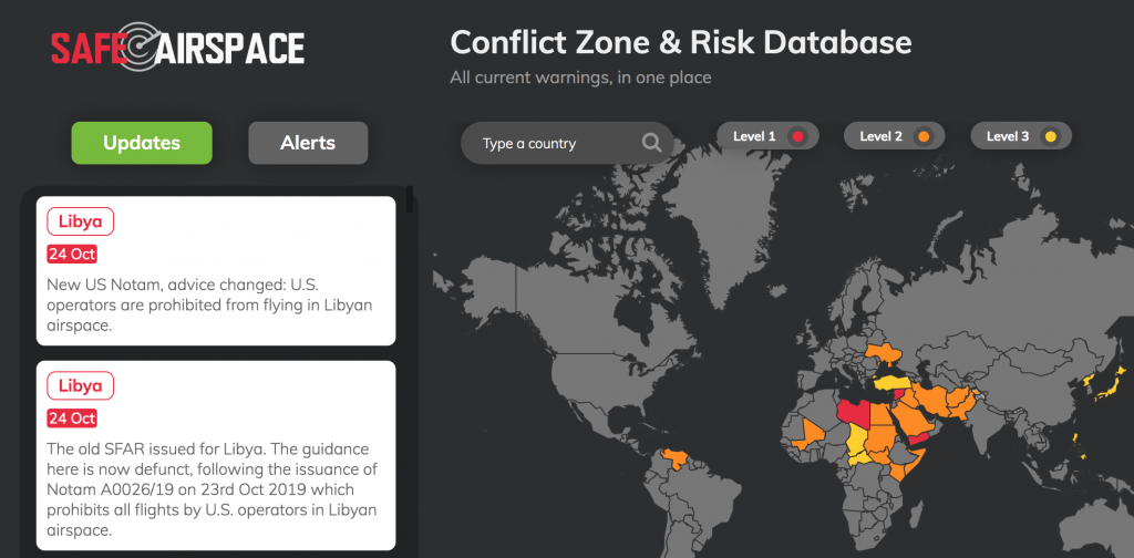
5th September, update:

As of this morning, most controllers have returned to work. Some concessions made by ECAA. Addis ACC and TWR are again staffed with qualified controllers, so the safety situation, for now, is restored. However, 9 remain in jail. Returning controllers were forced to sign an ‘admission’ of illegal strike action in return for amnesty. IATA In Flight Broadcast Procedure requirement for Addis FIR remains in place, meaning you must broadcast on 126.9 as in other areas of concern in Africa. Further as we get it.


4th September:

Last week we were one of the first to expose the attempted ATC Strike cover up by the Ethiopian Civil Aviation Authority.

As a reminder, untrained and uncertified foreign controllers, retired and local non-operational ATC personnel are being used to control air traffic over Ethiopia. 

It is a catastrophic misjudgement, creating a safety risk in the Addis FIR and at Ethiopian Airports for pilots and passengers alike.

Here are some more updates since our last article:

  • On August 29, The International Federation of Air Traffic Controllers Association (IFATCA) penned a letter to the Prime Minister of Ethiopia. You can read it here.
  • The neighbouring controllers in Kenya warned that flights in and out of Addis Ababa are not safe. You can view their letter here – specifically they warned that the ‘possibility of air misses’ is real.
  • The ECAA over the weekend rejected concerns regarding the safety of Ethiopian airspace, specifically calling the claims from Kenya as “outright lies.”  The ECAA has said that ATC are operating “in accordance with ICAO Annex 1 provisions.” They did not deny however that foreign and retired ATC are being used.
  • The ECAA also outlined that the national carrier, Ethiopian Airlines, has “awarded” veteran Air Traffic Controllers,  who are performing their national obligation.
  • However on Monday, the local state affiliated broadcaster, Fana BC, reported that the Federal Police Commission had detained nine individuals on suspicion of attempting to disrupt international flights and coordinating a strike that began last week. This has been quickly condemned on social media, as many locals called on the government to resolve the issues raised by the ATCs rather than resorting to intimidation.

The ECAA claims that “some” of the striking controllers have returned to work.

Major airlines and uninformed passengers continue to fly into and over Ethiopia and this continues to be a major safety risk.

Do you have more to add this story?  Please, let us know!


The risks posed to civil aircraft by surface-to-air missiles

In Short: Worldwide the SAM threat is deemed to be “low” by ICAO with the caveat that this can change quickly when flying over or near conflict zones. The best risk mitigation is centred around which airspace you are operating over and what information you have access to. As we have explained before: There is no safe altitude from a large SAM.

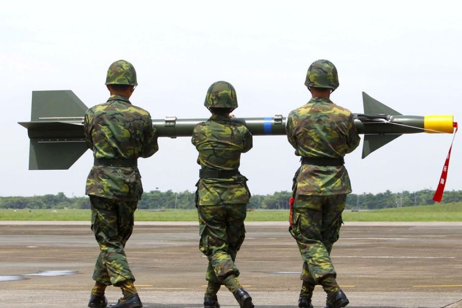
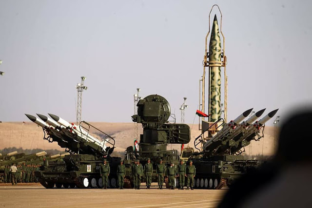
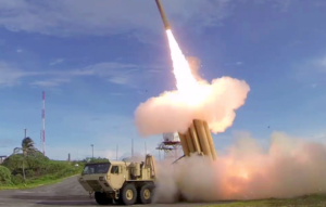
What are surface-to-air missiles, and who has them?

Surface-to-air missiles (SAMs) are large, complex units, with the capability of reaching aircraft at cruising levels well above 25,000 ft, and they are designed to be operated by trained military personnel.

They are distinct from Man Portable Air Defence Systems (MANPADS), which are the smaller, shoulder-launched systems, the most dangerous of which being the FIM-92 Stinger which has an operational ceiling of 26,000 ft.

SAM systems vary but they are all designed to track and destroy military targets in flight. Due to the size and predictable flight paths, civil aircraft represent easy and highly vulnerable targets.

Many SAMs are mobile and can be moved quickly between locations. Many are located on warships. It is estimated that more than 70 States around the world have acquired SAMs as part of their military capability. A small number of non-State actors (i.e. militant groups) have also reportedly acquired SAMs, but as they require a radar system as part of the mechanism, they may not have the technical capability to use them. To date, SAMs have never been used by terrorists.

What has happened in the past?

There have been three documented occurrences where aircraft destruction has occurred due to SAM attacks.

The risk of intentional attack

To date, no documented case of intentional SAM attack on a civilian aircraft has been identified. In the case of MH17 and Iran Air, both occurred during periods of military conflict or high tension, whilst Siberia flight 1812 was shot down during a military training exercise.

ICAO say that “with regard to the States and non-State actors that currently do have access to SAMs, there is no reason to believe that the intent currently exists to target civil aviation deliberately.” And with regards to terrorist groups (as opposed to militarized forces), they say that “even where intent may exist there is currently no evidence of capability (in terms of hardware and trained personnel).”

Overall, the current risk to aviation from intentional SAM attack is therefore currently assessed to be low, the key caveat being to avoid overflying airspace over territory where terrorist groups tend to operate – normally areas of conflict where there is a breakdown of State control.

The risk of unintentional attack

Past events show us that the higher risk to civil aviation is from unintended and unintentional attacks when flying over or near conflict zones – missiles fired at military aircraft which miss their target, missiles fired at civil aircraft which have been misidentified as military aircraft, and missiles fired by State defence systems intended to shoot down other missiles.

Areas where there are armed conflicts going on clearly present an increased risk of an unintentional attack. But when assessing the risk of overflying a particular conflict zone, here are some more specific questions to consider:

Are there increased levels of military aircraft flying around in the region?

This could be anything from fighter jets being operated in a combat role, or for hostile reconnaissance; remotely piloted aircraft; or military aircraft used to transport troops or equipment. If military aircraft are one of the most likely targets for intentional attacks, then the chances of civil aircraft being mistakenly targeted increases in those areas where there are lots of military aircraft zipping around.

Are there likely to be a bunch of poorly trained or inexperienced personnel operating SAMs in the region?

This may be difficult to evaluate, but the risk is likely to be highest where SAMs may have been acquired by non-State actors. The risk is also likely to be higher in places where there is less of a robust command and control procedure for launching missiles, thus increasing the risk of misidentification of civil aircraft.

Is the territory below the airspace fully controlled by the State?

If not, and there are some areas controlled by militant or terrorist groups, the information on the presence and type of weaponry in such areas, as well as the information on who controls them, may not be readily available. In such regions, the information promulgated by the State about the risks to airspace safety may therefore not be 100% reliable.

Does the route pass over or near anywhere of particular importance in the context of the conflict?

These could be areas or locations that may be of strategic importance or sensitivity in the conflict, such as key infrastructure or military sites, which might be considered potential targets for air attack and would therefore be more likely to be guarded by SAMs.


Ultimately, risk mitigation is centred around which airspace you are operating over and what information you have access to. But as has been reported in the past, history has shown us that badly-written information published by the State often does little to highlight the real dangers posed by overflying conflict zones.

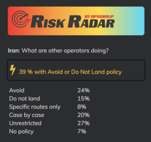
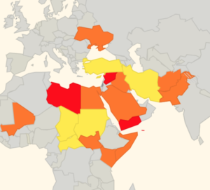
There is some evidence to suggest that more States are starting to provide better guidance and information to assist operators in making appropriate routing decisions, but we think this still has some way to go.

That is why we have been running our safe airspace map to provide guidance to assist operators in determining whether to avoid specific airspaces around the world.


Extra Reading:


Dubai to London – which way is best?

In Short: Two main options, via Saudi and Egypt (safer, cheaper but longer) or via Iran and Turkey (shorter, busier and geo-politically more unstable). It’s a complicated planning climate at present. Review regularly based on latest risk factors.   

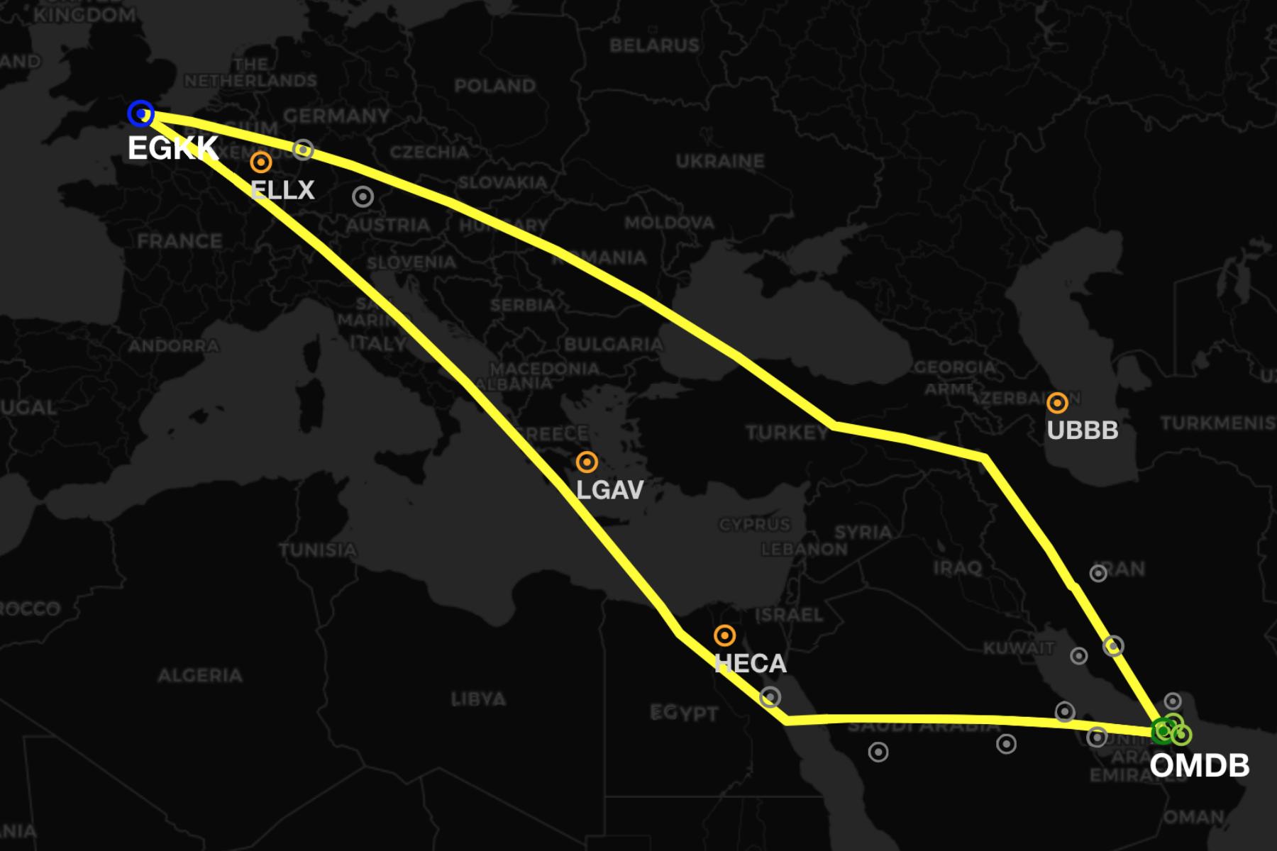
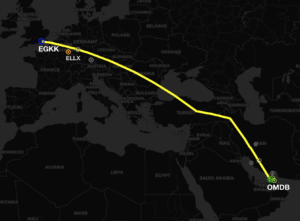
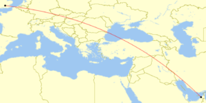
There are more business aviation operators flying between the Middle East and Europe than ever before. So we took the time to look over the route options between the two regions. For our example we will be using a flight from Dubai to London, but similar operational considerations are valid for the plethora of route combinations through this whole region.
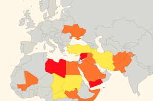
Firstly, we are sure you are a frequent visitor to our safe airspace website. Updated all the time with the latest notes and risk recommendations based on the latest intel. So, first things first, we want to avoid Syria, Libya and the Sinai Peninsula. As you can see however, this is a complicated geo-political region for flight planning. The direct great circle route would take us through Syria and would be around 3125nm. But that isn’t going to work. So, what else we got?

We will look at the two ways to head over the region. One is via Iran, Turkey and onwards to Europe. The other over Saudi Arabia and Egypt towards Europe.

Option 1: Iran/Turkey

Safety: Both Iran and Turkey are FSB Risk Level: Three – Caution. Iran is involved in the ongoing conflict with Syria and several Russian missiles crossed the Tehran FIR and several busy international routes. There are also increased tensions between the USA and Iran at present – if you had to divert in an N-reg aircraft, Iran would not be the friendliest of places to do so. Turkey borders with Syria and we have received multiple reports of GPS interference in the area.

Distance: an extra 100nm.

Time: About 15 minutes longer than great circle route.

Ease and Cost: Iran has higher overflight costs and for US based operators a reminder of the sanctions for dealing directly with Iran, or agencies in Iran. You’ll want to use an approved agent if you’re from the US (i.e.–not an Iranian company). Iran doesn’t work on Fridays, so be aware there. Turkish overflight costs are reasonable and remember that Turkish authorities require the use of an agent to apply for permits.

Traffic: The biggest issue with this route is that everyone is using it! It’s congested with a lot of airline traffic. It’s a major corridor for Asia-Europe flights also. So, getting the levels you want, and off route deviations are more complicated. Things get busy, as you can see!

Option 2: Saudi/Egypt

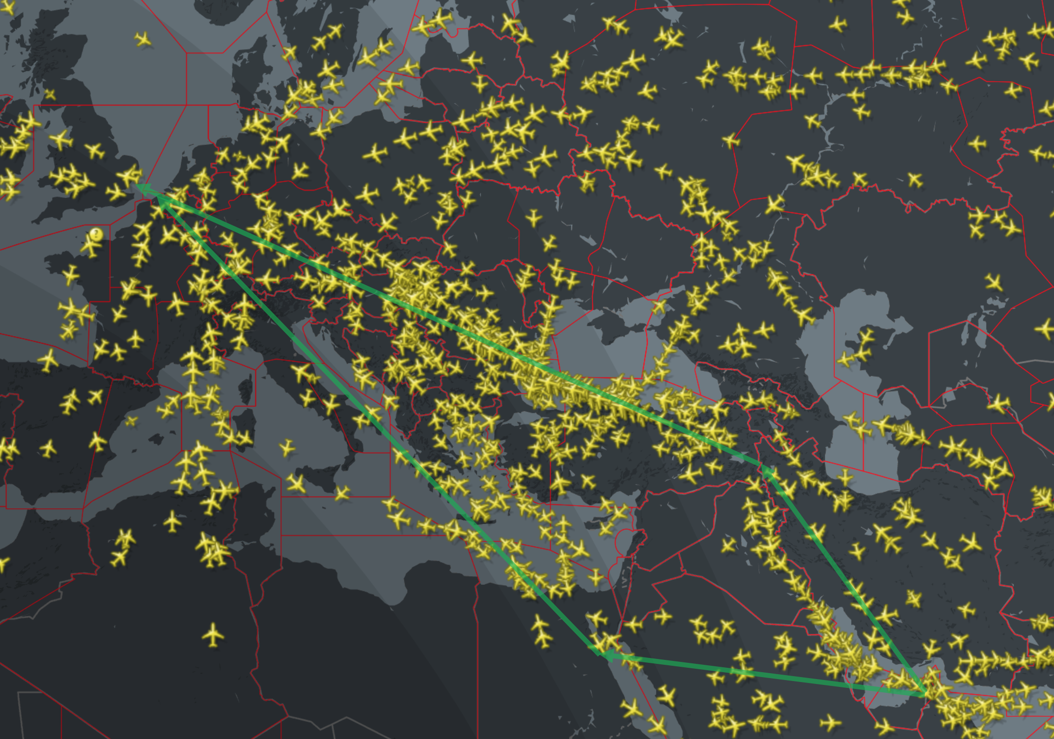
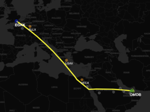
Safety: In terms of airspace warnings and risk, this route is slightly better. We have rated Saudi and Egypt airspace as FSB Risk Level: Two – Assessed Risk. Beyond the Sinai Peninsula and the Saudi/Yemen border, generally there is less of a chance of airspace security risks at present.

Distance: An extra 300nm from the great circle.

Time: Around 45 minutes longer.

Ease and Cost: Saudi and Egyptian airspace are generally a cheaper option ($1,000USD+). In Egypt, by law you have to get your permit through an Egyptian agent, but it’s a straight forward process. In Saudi, again, using an agent is best; they normally have three-day lead time – so keep that in mind. Also remember that the CAA only work Sun-Wed during office hours.

Traffic: For most of the day, much less of a traffic bottle neck.


Bottom line

Of the two options, routing via Saudi/Egypt is cheaper, and safer (as long as you steer clear of Egypt’s Sinai Peninsular and Saudi’s border with Yemen), but it’s going to take slightly longer.

What about Iraq?

We don’t think it’s a good idea. There’s a lot of information out there saying certain airways are ok but only at higher levels. But if you needed to get down fast, or even make an unexpected landing, Iraq isn’t the place you would want to go at present. Treat with caution.

Which one is your favourite choice? Let us know!

Further reading:


Unsafe aircraft not welcome in Europe

Eurocontrol and the European Aviation Safety Agency (EASA) have brought live an automated system which alerts air traffic controllers when unsafe aircraft enter European airspace.

How does it work?

Network Management Director at Eurocontrol Joe Sultana, explained that “We have added another parameter to our system, and this is now checking if an aircraft coming from outside of Europe is coming from a state where the regulatory environment is accepted by the European Aviation Safety Agency”.

So in short: The system will now take an automatic look at the Third Country Operator Authorisation and alert ATC if there is a flight being operated from a aircraft on the banned list.

The regulation that a plane coming from a non EU country must have a Third Country Operator Authorisation has been in place since 2014, but controllers have had no way to implement it across the 30,000 flights it receives into Europe each day, until this new component was entered into their systems.

As a reminder, Eurocontrol receives the flight plans of all aircraft entering into European air space, while the EASA holds the Third Country Operator Authorisations information which confirms that planes are from countries with recognised safe regulatory practices.


Dash 8 set on fire in Papua New Guinea, airport closed indefinitely

AYMN/Mendi has been closed indefinitely after protesters set fire to and destroyed an Air Niugini Dash 8 aircraft, which had just arrived from Port Moresby. The protest was in response to a court ruling confirming the election of the Southern Highlands governor William Powi.

Radio New Zealand reported:

“(Initially) the local police station commander Gideon Kauke had said police were guarding the aircraft to ensure there was no further damage, after its tyres had been flattened.

But he said his team of about ten police couldn’t contain a mob of uncountable numbers, particularly after missiles were thrown, forcing them to retreat; “we were guarding the plane but compared to them we were outnumbered and they came in all directions, all corners. Missiles were thrown, bush knives were thrown.”

Mr Kauke said some of the protestors, who continue to behave menacingly in Mendi as their numbers build up, were carrying guns. He said the protest was in response to a court ruling in Waigani confirming the election of the Southern Highlands governor William Powi.”

The Australian Department of Foreign Affairs is cautioning all to “reconsider your need to travel” to the regions affected by the unrest and to also “exercise a general degree of caution” for the whole of PNG.

The local NOTAM says it all.

A0773/18 – AD CLSD TO ALL ACFT OPS DUE CIVIL UNREST. 14 JUN 05:35 2018 UNTIL 13 JUL 06:00 2018 ESTIMATED. CREATED: 14 JUN 05:52 2018

Additional reporting indicates that the aircraft was shot at on landing, deflating the tyres.

Are you currently in PNG and can fill us in on more? Please comment below, or email us.


Europe squawks 7600 on ops in the Eastern Med

As we reported last month,  Eurocontrol published a ‘Rapid Alert Notification’ on their website regarding imminent air strikes into Syria.

“Due to the possible launch of air strikes into Syria with air-to-ground and / or cruise missiles within the next 72 hours, and the possibility of intermittent disruption of radio navigation equipment, due consideration needs to be taken when planning flight operations in the Eastern Mediterranean / Nicosia FIR area.”

Around this time LCCC/Nicosia FIR released this vague (and now deleted) NOTAM:

A0454/18 – INFORMATION TO AIRSPACE USERS

THE DEPARTMENT OF CIVIL AVIATION OF THE REPUBLIC OF CYPRUS IS CONTINUOUSLY MONITORING THE GEOPOLITICAL DEVELOPMENTS IN THE REGION AND WILL NOTIFY THE AVIATION COMMUNITY IF AND WHEN ANY RELEVANT AN RELIABLE INFORMATION IS AVAILABLE THE DEPARTMENT OF CIVIL AVIATION IS TAKING ALL APPROPRIATE ACTION TO SAFEGUARD THE SAFETY OF FLIGHTS. 12 APR 15:25 2018 UNTIL 12 JUL 15:00 2018 ESTIMATED. CREATED: 12 APR 15:26 2018

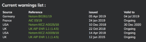
Beyond this alert and NOTAM though; nothing else happened. A few days later, the conflict escalated.

Very few commercial flights operate over Syria, and authorities in the US, UK, France and Germany have all previously issued warnings for Syrian airspace.

But many airlines regularly transit the LCCC/Nicosia FIR: there are frequent holiday flights to the main Cypriot airports of LCLK/Larnaca and LCPH/Paphos; overflight traffic from Europe to the likes of OLBA/Beirut, OJAI/Amman and LLBG/Tel Aviv; as well as traffic from Istanbul heading south to the Gulf and beyond.

What has happened in the few weeks since then?

Normal Eurocontrol protocol is (during expected ATC strike for example) – regular teleconferences with operators, active re-routes and removal of certain overflight approval requirements. So did that happen this time? No.

Essentially just radio silence on Syria and operations in the Eastern Mediterranean Sea.

Right now, it’s a busy place. With all the normal holiday traffic in the region, there is also a large number of military surveillance aircraft from numerous nations patrolling the region. United States assets operating from Greece and Italy. UK air power from Cyprus and the French from bases in Jordan. Add to that the normal Israeli defense air frames and even the odd Swedish gulfstream surveillance flight!  Then there are the Russians conducting aerial operations and defense exercises in and around Syria.

Cyprus has activated a litany of “temporary reserved/segregated areas” inside of Nicosia FIR.

On May 3rd, Cyprus issued this vague information, to ‘exercise caution’.

A0580/18 – NAVIGATIONAL WARNING TO ALL CONCERNED. EXTENSIVE MILITARY OPERATIONS IN NICOSIA FIR PILOTS TO EXERCISE CAUTION AND MAINTAIN CONTINUOUS RADIO CONTACT WITH NICOSIA ACC. 03 MAY 12:00 2018 UNTIL 31 MAY 23:59 2018. CREATED: 03 MAY 11:25 2018

There is also a current warning about GPS interruptions.

A0356/18 – RECENTLY, GPS SIGNAL INTERRUPTIONS HAVE BEEN REPORTED BY THE PILOTS OF THE AIRCRAFT OPERATING WITHIN SOME PARTS OF NICOSIA FIR. AIRCRAFT OPERATORS OPERATING WITHIN NICOSIA FIR ARE ADVISED TO EXERCISE CAUTION. 20 MAR 10:04 2018 UNTIL PERM. CREATED: 20 MAR 10:05 2018

It may be unfair to blame the authorities completely. At the end of the day, due to the lack of appropriate communication from the various security agencies it’s hard to get accurate information out there. Still, there was enough warning to alert civilian operators of imminent strike – but then nothing else. Shouldn’t airspace customers and users expect more?

So what to make of all this?

Let’s end it with this great 2009 (and still current) NOTAM from the Cypriots.

A0687/09 – NAVIGATION WARNING TO ALL CONCERNED.

15 SEP 09:30 2009 UNTIL PERM. CREATED: 15 SEP 09:34 2009


Who is still flying over Syria?

We have reported recently on the complex airspace picture and dangers associated with the ongoing Syrian conflict.

Most major carriers have taken the advice of numerous government agencies to avoid Syrian airspace altogether; the FAA going as far as calling on all operators flying within 200 nautical miles of the OSTT/Damascus FIR to “exercise caution”.  Today, the only airlines flying over the airspace are locally based Syrian airlines, Iraq Airlines and Lebanon’s Middle Eastern Airlines.

These MEA overflights are of interest. The airline is a member of the
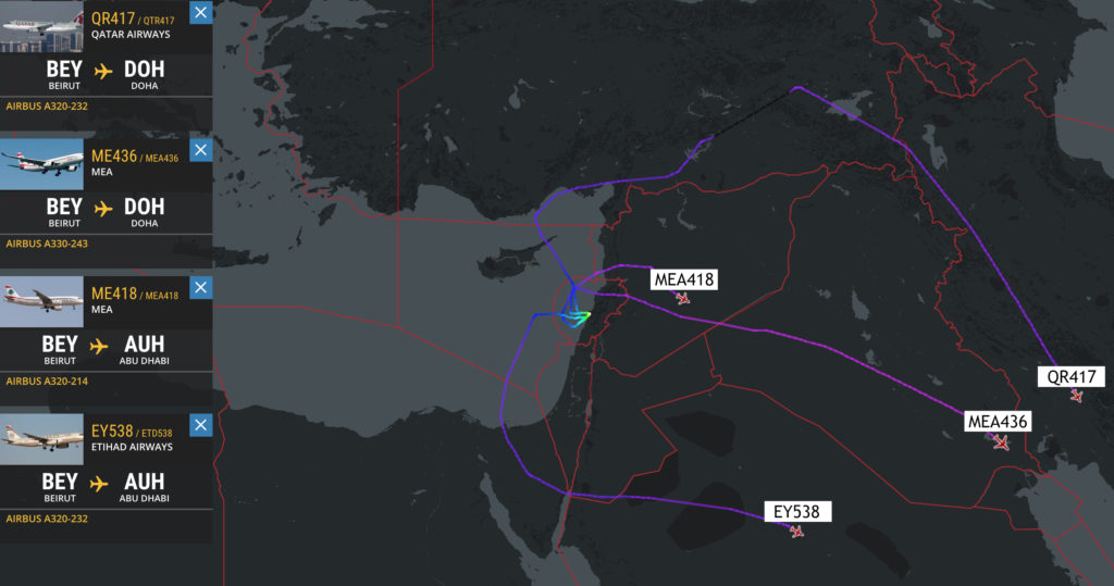
 SkyTeam alliance and has codeshare agreements with several high-profile airlines (Air Canada, Air France, etc.) Despite the repeated warnings of the ongoing dangers associated with overflights of this conflict zone, the airline has chosen to schedule more than half-a-dozen flights over the airspace each day.

Some of these flights have the usual codeshare practise of other airlines booking their passengers on MEA flights. Our research shows that Etihad Airways, Qatar Airways (Oneworld Alliance) and Royal Jordanian Airlines (Oneworld Alliance) passengers are still being booked on MEA flights to/from Beirut; likely unbeknown to their customers of the increased flight risk. All three airlines continue to service Beirut with their own aircraft, but all three avoid Syrian airspace, naturally accepting the best advice to avoid the area completely.

Something isn’t right here: no warning anywhere about these flights being flown over Syria.

So why is it safe for passengers to overfly Syria on an MEA flight, but not on any of the other airlines? And more importantly, why is MEA still operating over Syria anyway?

It looks like Kuwait Airways will be the next codeshare partner of MEA, so it will be interesting to see whether the issue of the overflight of conflict zones will be discussed.

As always, keep an eye on our Safeairspace map for the latest worldwide updates.


Japan scrambles record number of jets as tensions rise with China

In Short: Japan scrambled a record number of fighter jets in the past year. The number rose to an all-time high of 1,168 in the year to March 2017, easily beating the previous record of 944 set at the height of the cold war in 1984. Chinese aircraft approaching Japanese airspace prompted 851 of the incidents, an increase of 280 over the previous year.

According to official figures released on Thursday, Japan’s Air Self Defense Force is scrambling fighter jets in record numbers as Chinese military activity escalates. Interceptions of Chinese planes rose by half in the year to March 31, in response to increases in the communist country’s activity in and around the East China Sea.

Japan worries that China is probing its air defences as part of a push to extend its military influence in the East China Sea and western Pacific, where Japan controls an island chain stretching 1,400 km (870 miles) south towards Taiwan. The figures highlight China’s growing assertion of military power in East Asia as it expands and modernises its armed forces in line with rapid economic growth.

For the first time, Chinese jets recently began flying through the Tsushima Strait into the Sea of Japan, and through the Miyako Strait into the Pacific Ocean.

But it’s not only China that Japan is worried about. Last week, Japanese Prime Minister Shinzo Abe warned North Korea may be capable of firing a missile loaded with sarin nerve gas towards Japan. “There is a possibility that North Korea already has a capability to deliver missiles with sarin as warheads,” he told a parliamentary national security committee.

And then there’s Russia. Scrambles by Japanese aircraft were high throughout the 1980s in response to flights by Soviet aircraft during the cold war. They fell back to 100-200 incidents a year during the 1990s and 2000s, but began to pick up again a decade ago as both China and Russia grew more assertive.

Mr Abe has been trying to negotiate with Russian president Vladimir Putin over the future of four disputed islands in the Kuril chain to Japan’s north, but has made limited progress, with the jet scrambles showing Moscow’s determination to make its presence felt on its eastern border. There were 301 scrambles to intercept Russian aircraft during the year, 13 more than the previous year, including incidents where Russian jets circumnavigated the Japanese Diaoyu/Senkaku Islands to the south.

Extra Reading:


US updates its Syria airspace warning

Following the US, UK and French airstrikes on Syria on April 14, the US FAA say there is now a risk posed to civil aviation within 200 nautical miles of the country due to increased military activity, GPS and comms interference, and the potential for more long range surface-to-air missiles in the area.

In the updated US FAA conflict zone Notam and Background Information for Syria, US civil aviation continues to be prohibited from operating within Syrian airspace, but has also now been instructed to “exercise caution” when operating within 200 nautical miles of Syria’s OSTT/Damascus FIR.

As they say in the Background Information doc, here’s why this updated guidance has been published:

“Heightened military activity associated with the Syrian conflict has the potential to spill over into the adjacent airspace managed by neighboring states and eastern portions of the Mediterranean Sea. Military operations may result in the risk of GPS interference, communications jamming, and errant long-range SAMs straying into adjacent airspace within 200 nautical miles of the Damascus Flight Information Region (OSTT FIR). These activities may inadvertently pose hazards to U.S. civil aviation transiting the region. This concern stems from the Syrian military response to previous airstrikes on 10 February 2018, which included Syrian forces launching long-range SAMs. Some of the Syrian SAMs flew into adjacent airspace and landed in Lebanon and Jordan, according to media reporting. GPS interference and communications jamming in the region may also occur associated with the military activity. Some U.S. air carriers have reported GPS interference in portions of the eastern Mediterranean Sea in the period following the 10 February airstrikes, and the interference may have originated from the Damascus Flight Information Region (OSTT FIR) as a defensive response.”

The US FAA haven’t provided a map to show where boundary would lie for 200 nautical miles from the border of Syrian airspace, but we think it would look something like this:

The 200 nautical mile zone would include the entire airspace of Lebanon, Jordan and Israel; half of Turkey and Iraq; and a portion of airspace over the LCCC/Nicosia FIR that covers the whole island of Cyprus!

The area may seem vast, but the possibility of further US, UK and French strikes against Syrian targets does still exist, as well as the Syrian military using surface-to-air missiles in response to any attacks.

During the airstrikes on April 14, the Syrian military reportedly used Russian-made missile systems to attempt to counter the strikes – these included missiles which have the capability to engage aircraft at altitudes well above FL900 and at ranges of around 190 miles.

While there is likely no intention to target civil aircraft, with all the missile defence activity going on in Syria and the spillover into neighbouring countries there still remains a risk of misidentification – and that’s what the 200 nautical mile warning seeks to address.

Amidst continued heavy military air presence in the region, almost all airlines are now avoiding Syrian airspace entirely. Lebanon’s Beirut based MEA has now also re-routed all of their flights to avoid Syrian Airspace (was using it post recent attacks). Only local operators Fly Damas, Charm Wing Airlines, Syrian Air and Iran’s Mahan Air continue to use the airspace.


Here’s what the Pentagon had to say about the airstrikes on April 14:

  • 105 missiles were launched in the strikes against Syria. They included 30 Tomahawk missiles fired from the USS Monterey and seven from the USS Laboon in the Red Sea. Another 23 Tomahawk missiles were launched from the USS Higgins in the North Arabian Gulf.
  • A submarine, USS John Warner, fired six Tomahawk missiles from the eastern Mediterranean and a French frigate in the same area fired another three missiles.
  • At least one US Navy warship operating in the Red Sea participated in airstrikes, as well as US B-1 bombers.
  • The air assault involved two US B-1 Lancer bombers, which fired 19 joint air to surface standoff missiles. The British flew a combination of Tornado and Typhoon jets, firing eight Storm Shadow missiles, while French Rafale and Mirage fighter jets launched nine SCALP missiles.
  • Four Royal Air Force Tornado GR4’s were used in the strikes, launching Storm Shadow missiles at a “former missile base — some 15 miles west of Homs,” according to the UK Ministry of Defense.
  • Syria fired 40 surface to air missiles ‘at nothing’ after allied air strikes destroyed three Assad chemical sites.
  • The United States remains “locked and loaded” to launch further attacks.
  • United States and Allies maintain positive posture of force in the region, especially in the air.

105 missiles launched from multiple locations in the region.
Over 40 Syrian surface to air missiles fired “at nothing”.

Further Reading:

A0454/18 – INFORMATION TO AIRSPACE USERS

THE DEPARTMENT OF CIVIL AVIATION OF THE REPUBLIC OF CYPRUS IS CONTINUOUSLY MONITORING THE GEOPOLITICAL DEVELOPMENTS IN THE REGION AND WILL NOTIFY THE AVIATION COMMUNITY IF AND WHEN ANY RELEVANT AN RELIABLE INFORMATION IS AVAILABLE THE DEPARTMENT OF CIVIL AVIATION IS TAKING ALL APPROPRIATE ACTION TO SAFEGUARD THE SAFETY OF FLIGHTS. 12 APR 15:25 2018 UNTIL 12 JUL 15:00 2018 ESTIMATED. CREATED: 12 APR 15:26 2018

If you have anything to share that we’ve missed, please tell us by email bulletin@fsbureau.org


Qatar airspace update – military jets intercepting civil flights

In short: The situation is volatile and constantly changing, even by the hour. Military interception has been reported so the best advice is to be vigilant with sticking to assigned routes for all operations around the region.

The airspace blockade of Qatar has been ongoing since June 2017 with little end in sight.

But over the past few months, tensions have been escalating;

Here is the latest operational information we have:

A reminder that Qatar does not have its own FIR. It sits entirely within the Bahrain FIR- you will find Qatar airspace NOTAMs under OBBB. The Doha TMA extends SFC to FL245. Above this sits the Bahrain UIR.

Bahrain and Egypt have relaxed some of their initial restrictions. Saudi and UAE have not.

The current state of play as of 6 April 2018.


_________________________________________________________________________

Have you been through the region recently? Can you provide an update?

Extra Reading:

Some fascinating reporting about what this whole blockade is all about.

  • How a ransom for Royal falconers reshaped the Middle East” – New York Times
  • What the falcons up with Qatar?” – NPR Podcast


New Unsafe Airspace Summary and Map

March 20, 2018: One of our biggest missions in OPSGROUP is to share risk information and keep operators aware of the current threat picture. The latest Unsafe Airspace Summary is now published, and available to members here as a PDF download (Unsafe Airspace Summary 20MAR2018, edition LIMA).

The main changes since the last summary are below. For a current risk map, refer to the Airspace Risk map in your member Dashboard.

The situation in Afghanistan remains similar. On March 13, Germany added wording to maintain FL330 or higher,  still recommending against landings at Afghan airports.

Germany also issued updated NOTAMs for Mali, Iraq, and South Sudan. All warnings remain as previous, unchanged from the prior NOTAMs.


Kenya airspace threat downgraded

The FAA has revised its warning for Kenyan airspace – the area to ‘exercise caution’ is now limited only to that airspace east of 40 degrees East longitude below FL260 (i.e. the border region with Somalia, and 12nm off the east coast of Kenya). Prior to this, their warning applied to all airspace in Kenya below FL260.

Published on 26 Feb 2018, the warning maintains the same wording to clarify the type of weapons and phases of flight that the FAA is concerned about, specifically:

  • fire from small arms,
  • indirect fire weapons (such as mortars and rockets), and
  • anti-aircraft weapons such as MANPADS.

The scenarios considered highest risk include :

  • landings and takeoffs,
  • low altitudes, and
  • aircraft on the ground.

The updated guidance is intended for US operators and FAA License holders, but in reality is used by most International Operators including EU and Asian carriers, since only four countries currently provide useful information on airspace security and conflict zones.

The Notam uses FL260 as the minimum safe level, though we would suggest, as usual, that a higher level closer to FL300 is more sensible.

You can read the NOTAM in full on our Kenya page on SafeAirspace.net, a collaborative and information sharing tool used by airlines, business jet operators, state agencies, military, and private members of OPSGROUP.


Feb 2018: Tel Aviv Airport closes as a precaution against attack

LLBG/Tel-aviv: Israel’s main airport briefly suspended operations on Feb 10, due to military clashes along the northern border with Syria.

Two Israeli pilots were forced to abandon their F-16 jet, which crashed near the border after being hit by a Syrian anti-aircraft missile. The jet was on a mission in which it struck an Iranian facility in Syria that had previously operated a drone which Israel shot down over its territory.

This resulted in all flights from LLBG/Tel-aviv Airport being grounded for around an hour starting at 9am local time, as a precaution against any further attacks. The airport is considered a strategic location that could be targeted during military conflict.

Here’s what Israel’s PM had to say about it:

This incident marks the most significant engagement by Israel in the fighting that has been taking place in neighbouring Syria since 2011. Israel has mostly stayed out of the conflict so far, but has recently become more concerned about the increased Iranian presence along its border.