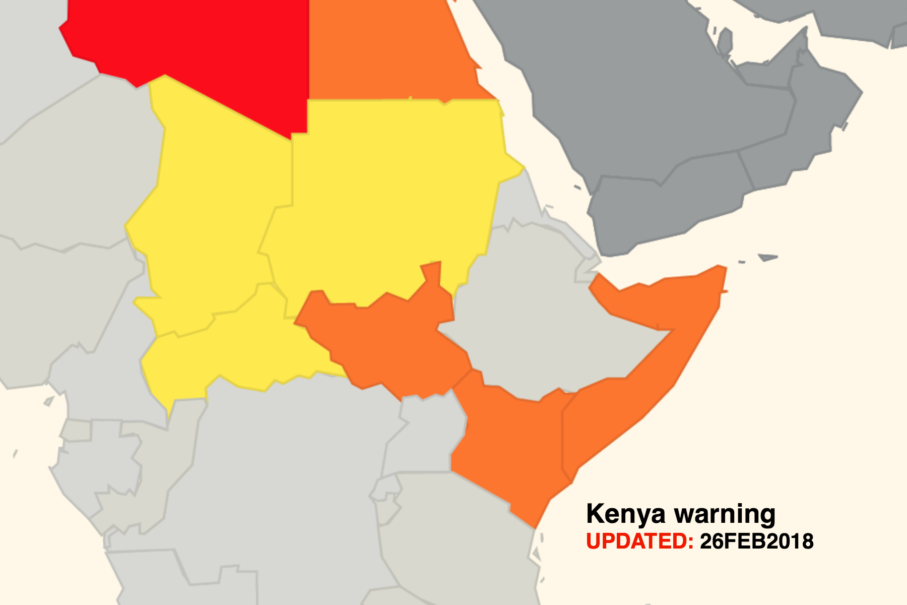
The FAA has revised its warning for Kenyan airspace – the area to ‘exercise caution’ is now limited only to that airspace east of 40 degrees East longitude below FL260 (i.e. the border region with Somalia, and 12nm off the east coast of Kenya). Prior to this, their warning applied to all airspace in Kenya below FL260.
Published on 26 Feb 2018, the warning maintains the same wording to clarify the type of weapons and phases of flight that the FAA is concerned about, specifically:
- fire from small arms,
- indirect fire weapons (such as mortars and rockets), and
- anti-aircraft weapons such as MANPADS.
The scenarios considered highest risk include :
- landings and takeoffs,
- low altitudes, and
- aircraft on the ground.
The updated guidance is intended for US operators and FAA License holders, but in reality is used by most International Operators including EU and Asian carriers, since only four countries currently provide useful information on airspace security and conflict zones.
The Notam uses FL260 as the minimum safe level, though we would suggest, as usual, that a higher level closer to FL300 is more sensible.
You can read the NOTAM in full on our Kenya page on SafeAirspace.net, a collaborative and information sharing tool used by airlines, business jet operators, state agencies, military, and private members of OPSGROUP.
More on the topic:
- More: FAA Warns on Runway Length Data and Overrun Risk
- More: Crisis in Iran: Elevated Airspace Risk
- More: New RISK WARNING: Somalia ATC Conflict
- More: US Shutdown Ends and FAA Lifts Flight Restrictions
- More: Updated FAA Oceanic Guides
More reading:
- Latest: Paris Ramp Checks: Illegal Charters and Tax Avoidance
- Latest: Middle East Airspace – Current Operational Picture
- Latest: Greenland NAT Alternates: March 2026 Update
- Safe Airspace: Risk Database
- Weekly Ops Bulletin: Subscribe
- Membership plans: Why join OPSGROUP?


I wonder why the threat to get shot in flight levels usually not used for flying over Somalia seems to have priority over the daily real threat of airborne collision in this area with no radar control, only flight information service done by the FIS of a neighboring country!
Ben,
You may want to check with the FAA. They distinctly use language that either references a “FIR” or “territory and airspace” for a reason. If they wanted to include that area of water, I’m sure they would’ve referenced the Nairobi FIR vs the territory and airspace language. It may help to ask the FAA vs inadvertently advertising the wrong info. I suspect you haven’t confirmed this.
I’m not sure that this is an accurate account of the latest FAA Advisory NOTAM for Kenya, since the NOTAM refers to the territory and airspace east of 40 degrees east longitude. Therefore, I don’t believe the FAA’s advisory applies to the airspace your visual depicts over water. Your visual would be accurate if the new NOTAM referred to advising US operators with the Nairobi FIR east of 40 degrees east longitude. But that doesn’t appear to be the case here since they only reference “territory and airspace.”
Hi BB,
With comment of “territory and airspace”, the water is a part of Kenyan airspace. I think our depiction is accurate as stated in the NOTAM.
EASA just reviewed its Conflict Zone Information Bulletin
CZIB No.: 2016-01R3
Issued: 01 March 2018
See CZIB-2016-01R3: Airspace of Kenya
http://easa.cmail20.com/t/d-l-otimtk-vhtyudihl-x/