Summer is coming in the Northern Hemisphere and so is the next Atlantic hurricane season, which runs from June to November.
But for the first time in eight years, experts in the US are saying it’s not going to be too bad this year – or rather, they are predicting a “near-average” hurricane season…

Everything will be fine.
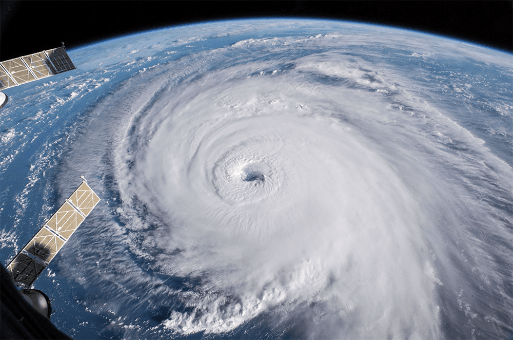
The 2022 season saw 14 named storms, eight hurricanes and two major hurricanes – which is actually pretty near average.
The worst of these was Hurricane Ian, which hit Florida at the end of September as a Category 4 major hurricane, tracking right across Florida before making a second landfall in South Carolina.
The two surprising things about the 2022 season were the lack of any storm in August (a time when Atlantic storm activity normally starts to increase), and the formation of three hurricanes in November (Lisa, Martin and Nicole) – right at the end of the hurricane season.
Here’s an animation of last year’s season’s highlights, thanks to the NOAA:
What does 2023 have in store?
CSU Tropical Weather & Climate Research have released their prediction for this season. Here’s the lowdown:
- Good news: “El Niño is virtually assured in the next couple of months” – meaning that increased winds from the Pacific will blast across into the Caribbean and Atlantic and help tear apart hurricanes as they try to form.
- Bad news: Warm waters in the tropical Atlantic are at “record levels in the eastern part of the basin” – meaning that ideal hurricane conditions are in place which will counteract some of the El Niño effect.
So although they say to expect a “near average” season, they really don’t know yet which way it will go. Or to put in proper met speak: “Given the conflicting signals between a potentially robust El Niño and a much warmer-than normal tropical and subtropical Atlantic, the team stresses that there is more uncertainty than normal with this outlook.”
Southwest hurricane season
This isn’t specifically a “northern hemisphere” thing because it affects countries both sides of the equator. Similar to the Atlantic season, it generally runs from June through September.
India, Pakistan, Sri Lanka, Myanmar, Bhutan, Bangladesh, Nepal, Cambodia, Laos, Thailand, the Philippines, and Vietnam are generally the most affected, although some of the nastier storms can track pretty far south.
Tropical systems bringing nasty weather, heavy rain and often strong winds are also associated with the season. You’ll find these forming in spots like the Arabian Sea, Bay of Bengal, and northern Indian Ocean.
The main impacts?
- Airport operations can often become the biggest nightmare for a pilot. Weather conditions will often shift as the storm moves through, so there may be windows where the wind is aligned with the runway, but don’t let the lack of crosswind fool you, as the turbulence and wind shear caused by the high winds will still present a considerable problem for your approach.
- Airports near the storm will often become full due to diversion traffic – so be on the lookout for Notams which often prevent their use as a planned alternative. Some regional airports might close to arrival traffic when they are filling up, so having fuel for an alternate some distance from the storm is handy.
- Be on the lookout for Notams affecting entire airways. In addition, there are often LSWDs (Large Scale Weather Deviations), and FIRs will modify route availability to assist their aircraft management.
- Carry extra fuel. This is especially true for those ultra long range flights. Weather at the time of your departure may be forecast OK. However, 12 hours is a lifetime for these storms, and the airport, which you thought would be OK, could be the storm’s firing line. Fuel will give you options.
- Be mindful of aircraft limitations and aware that ATC may not pass on info if they’re busy. Ask the approach controller how many aircraft have made successful landings in the past 30 min, just to help create a picture of how things are on the ground.
- After storms pass, the local region can be isolated due to flooding and damage. Power and water are often cut off, and essential services may be limited. For airports, manpower and fuel could be an issue, so FBOs/handlers may not be able to assist with your arrival for days after the storm has passed.
Understanding the forecasts
During hurricane season, some terms get thrown around that aren’t always that clear.
Especially:
- The difference between a storm and a hurricane.
- What categories actually mean.
- The actual effect of these categories on the ground.
Hurricanes are measured on a 5-point scale. The bigger the number, the more destructive it will be. Here’s a handy little graphic, courtesy of the National Hurricane Center:
Getting good intel
Keep an eye on the FAA OIS website and NOAA website. When new storms form, daily telcons are activated that anyone can dial into. They provide up-to-the-minute operational updates on airports and airspace.
Prepare to help!
After a disaster, we know that knowledge is critical. Getting good information to relief workers literally saves lives – which is why OPSGROUP established Relief Air Wing. It is a team of OPSGROUP volunteers who come together in the aftermath of these storms to help share information to relief agencies so that help can get through to where it is needed the most.
Our community contains thousands of skilled pilots, air traffic controllers, dispatchers and other professionals and together we can make a real difference. Head on over to the Relief Air Wing website for more info on our mission and how you can help.
More on the topic:
- More: Hurricane Milton – Florida Under Warning
- More: Hurricane Beryl
- More: Hurricane Idalia: Florida Airport Closures – 1200z Aug 30
- More: Hurricane Freddy: Still going strong
- More: 2020: A Record Breaking Hurricane Season
More reading:
- Latest: Gander’s Bringing Back CPDLC Oceanic Reroutes
- Latest: EU Temporary Admission of Aircraft – Busting Myths
- Latest: US Ops Update: Speeds, Squawks and Slippery Runways
- Safe Airspace: Risk Database
- Weekly Ops Bulletin: Subscribe
- Membership plans: Why join OPSGROUP?


Nice copy and paste Opsgroup