We’ve sent out a lot of updates in the last 12 months about changes on the North Atlantic; if we go back 45 years you’ll see that navigating was a little different – but for all that has changed, much is still the same.
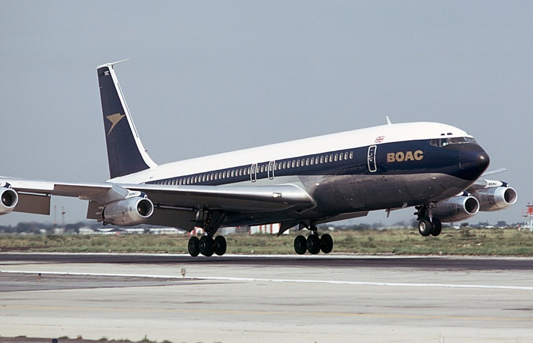
This Flight Log is from the Delivery Flight (KSEA/Seattle-EGLL/London Heathrow) of Boeing 707 G-APFN, which took place on 18NOV1960.
Home via the Pole
Our take-off weight was 130,500kg, of which 72,000kg represented full tanks. We needed, with all allowances, 66,500kg of fuel for the 4,210 n.m. flight. Estimated flight time 8hr 42min on a minimum-time track, with average +24kt wind component, calculated by BOAC’s New York dispatching office and received in Seattle by telephone. The 72,000kg of fuel would give us 11 hr 48 min endurance.
Track: Carmi, Churchill, Frobisher, 64°N at 50°W, 56°N at 10°W, Bush Mills, London. Flight level 330 to 90°W, 370 to 20°W, then 410. Take-off about 1700hr local, 0100Z (GMT). Take-off clearance: “Climb on runway heading to 3,000ft: left turn to heading 340° to intercept 030° radial of Seattle VOR: climb NE-bound until 15,000ft via direct Carmi: maintain flight level 330. Transition height, 24,500ft because of the mountains. Gets dark during climb, red rotating beacons reflecting off pods; flight deck almost Christmas-like in red and white lights on grey panels: everyone head-down working hard, except pilots peering into night sky. We press on to cruising height, mostly using DR plot and scattered NDBs with occasional VOR. Talking to all sorts of stations on VHF and HF, asking for position reports to be passed to BOAC at Montreal.
Distinctly Canadian accents on radio. Change heading from 025° to 060°. Meet jarring turbulence: navigator’s plot shows sharp wind-change: radar shows thunderstorms: temperature drops rapidly; lights dimmed and captain stares into black night, hand on autopilot heading control. This is a jet stream—and rough! Decide to climb straight to 370 to get clear, and notify control. Using both VHF and HF almost constantly. Pass Tippo Lake at 0202Z estimating Churchill at 0300Z. Dull, furtive veils of northern lights snaking above us—
ADFs tuned to Frobisher NDB, no astro. Outside air temperature—52°C. Hear SAS over-the-Pole flight asking to climb from 280 to 310 at 0449Z, position 70 °W, 66 °N. KLM flight is there too. Northern lights seem to have gone. We talk to “Leeway” on VHF.
0445Z: Note from co-pilot Lee, “Leeway is defence radar at Frobisher: we saw their lights on the ground: have now returned to compass steering: will get radar fix on No 2 VHF at about 0455Z: now reporting to Goose on No 1 HF.” Our report, read from a form, gives estimate for 64°N, 67°W as 0509Z, the wind found, fuel state and consumption, speed, ETA for London and much besides. Goose asked to repeat to Gander and Montreal for BOAC, to Sondrestrom for ATC. Sondrestrom cannot understand, so Goose changes HF frequency to try again. “Leeway” fixes us by radar at 120 miles. SAS and two other BOAC aircraft talking on HF. Navigator plotting all the time; engineer fills in fuel tables every 5,000kg, about every 40min. Pressurizing on one turbocompressor and two direct engine bleeds. We call Prestwick on HF, apparently without reply.

0530Z: Northern lights sneak up again. ADF tuned to Kook Island NDB, mid-west of Greenland, and we see its lights below. Whoever lives there? No. 2 ADF getting Christiansund NDB, 320 miles away on southern tip of Greenland. At 37,000ft: TAS 475kt; two minutes up on ETA; winds northerly; engines at 88 per cent r.p.m.; radar tilted down 7° for mapping.
0542Z: Temperature — 55°C. Air has been smooth for hours. Captain and navigator still hard at it, co-pilots and engineer relieved. Passenger cabin a dark, empty tunnel—only nine seats fitted. Dead of night, northern lights stealing about.
0625Z: At 35°W and 37,000ft. Hope to climb at 30″W. Three min ahead of plan. No VHF contacts. Iceland cannot hear our HF, so relaying via Sondrestrom. Expect to contact weather ship on VHF at 0645 and get fix. Nearest to Iceland at 0700. Many other aircraft south of us calling Gander. Receive HF weather broadcast from Shannon giving shallow fog for most British airfields; also Canadian maritime weather broadcast from Gander. Frobisher has a 9,000ft runway good for a diversion. Our point of no return relates to Gander. But now we have the feel of the other side and are heading south-east for Britain.
0800Z: Wake with a start from sleep to see a hard yellow, copper and pale green dawn rising over us. Still making 480kt true on 132°. ATC has held us down to 37,000ft; passing 10°W and estimating Bush Mills at 0830Z. Windscreen frames now thickly coated with frost. The sun begins to shine dazzlingly straight in at the windscreen, and shades are down, lights turned low. Outside temperature — 48 °C. Captain still in seat. Navigator makes complete table of airways check-point ETAs for Red 1 and Amber 1 via Belfast, Isle of Man, Wallasey, Lichfield, Daventry, Beacon Hill and Watford to LAP’s runway 28R.
Descent to begin at 0852 and to last 24 min at mean TAS of 364kt, using 800kg fuel. Engineers plan pressurization management between bleeds and turbos when throttled back on descent. ETA London 0916Z with 19,000kg of fuel remaining at 1,000ft. The tip of Ireland is painting well on radar at 60 miles. Sun is blinding. A leaden sea visible between dollops of cloud thrown almost up to our level in polar maritime cold air. IAS 250kt; M0.82; r.p.m. 88 per cent; o.a.t. — 48 °C; cabin height 6,000ft. Navigator hands time plot to co-pilot and relaxes slightly. HF weather reports in French. Cillard RAF radar (in Scotland?) has us. English voices, clipped and calm in welcoming efficiency.
0820Z: Ireland in sight. Centre and reserve tanks now dry, remaining fuel distributed in wings.
0837Z: Cillard loses us and we switch to Scottish Airways control. Estimate Isle of Man at 0843. Prepare-for-descent checks read out. Landing weight will be 77,500kg—very light—VREF 126kt, target threshold speed 135kt, maximum threshold speed 149kt.
0842Z : Pass Isle of Man, in sight below, together with coasts of Wales, Ireland, England and Scotland, and request descent clearance for 0851. At 0846 cleared down to flight level 210 and call Preston. Throttle outers to 68 per cent and inners to 87 per cent r.p.m. Descending at M.O.68 at 700ft./min. Wallasey at 0853.
0900Z: The Pennines lava-like in valley fog and snowy tops. Joddrell Bank telescope like a deployed parachute far below. Atlantic charts and manuals being cleared away. Pass Lichfield, estimating Daventry at 0907, tuning beacons, change to London control. 250kt i.a.s., jolted in rough air. Daventry at 0907, estimating Beacon Hill at 0913. Cleared to flight level 190. Watford on No 1 ADF, Dunsfold on No 2 ADF. Find Beacon Hill by Flying Dunsfold range leg to a bearing from Watford. Under London radar surveillance from Daventry. Cleared to flight level 080. Don’t confuse Beacon Hill with Woburn, check with ADF. l,000ft/min now at 150. Wheels rumble down for airbrake effect, slow to 200kt at 2,500ft/min; trying to make Watford at 8,000ft. Over Watford at 11,000ft radar takes us straight on to a southerly lead-in for ILS, asks our rate of descent.
Runway visibility 1,500yd. Still on autopilot, in cloud. Flap coming down. See Greenwich through a hole in cloud, then Crystal Palace. A helicopter is reported leaving Battersea. Approach checks read. Autopilot-coupled glide-path and localizer armed. Radar vectors us on to centre-line. Speed coming back to 150kt at 3,200ft. QNH set on co-pilot’s altimeter, QFE on captain’s. Height 2,100ft, glidepath coupler engaged at 152kt, going down at 900ft/min into dull mist. Melted frost dripping fast from window frames. Captain’s hand poised on control wheel. Windscreen wipers working hard. Lead-in lights now dimly in view, but no trace of runway. BEA engineering base comes into sight to our left, co-pilot postively identifies runway and tells captain.
We surge in past the lights, the captain cuts the autopilot and holds off. When I think we are still 100ft up, the main wheels touch smoothly, the nose comes down, spoilers are popped out, reverse thrust pulled. Further end of runway still out of sight. The captain takes the nosewheel tiller and starts braking while the co-pilot holds the column forward and calls the decreasing speeds down to 60kt. We turn off with some runway to spare, switch to airfield control frequency. Shutting down checks begin.
We are home. Chock-to-chock time 9hr 15min for 4,210 n.m.: we took off at about 1700 hr Seattle time and it is now 0130 by that reckoning— time for bed. But here in London it is 0900hr or so and a new day is just beginning. This is the way to travel if you don’t weaken ..
This is an exerpt from an article originally published by Mark Lambert in Flight International in 1960.
More on the topic:
- More: Gander’s Bringing Back CPDLC Oceanic Reroutes
- More: EU Temporary Admission of Aircraft – Busting Myths
- More: US Ops Update: Speeds, Squawks and Slippery Runways
- More: FF-ICE is here, and no one cares
- More: Middle East Airspace – Current Operational Picture
More reading:
- Latest: Gander’s Bringing Back CPDLC Oceanic Reroutes
- Latest: EU Temporary Admission of Aircraft – Busting Myths
- Latest: US Ops Update: Speeds, Squawks and Slippery Runways
- Safe Airspace: Risk Database
- Weekly Ops Bulletin: Subscribe
- Membership plans: Why join OPSGROUP?


Fantastic! we at Varig Airlines were used to fly to Europe and Africa besides New York and a few other countries in the same kind of aircraft. We had lot of funs. Danilo
Fascinating! I’ve made the exact trip many times myself but to travel back in time was fun! Thanks for the flight log! Maybe one day someone will read one of mine.