NAT Crossing after GPS spoofing: a guide
An increasing issue for the NAT Oceanic FIR’s is how to handle aircraft with an in-flight degradation of GPS. This normally follows a GPS Spoofing encounter somewhere prior to Oceanic Entry, leading to a degraded RNP capability.
If you run into GPS issues before entering the Ocean, you will likely end up with RNP10 as the best you can manage for navigational accuracy. This presents some issues for the Oceanic controllers, as RNP4 is commonly used to ensure separation. We’ll take a look at some scenarios and how to best handle these.
Normal RNP requirements on the NAT
NAT Doc 007 specificies two RNP options for entry into the NAT HLA.
The first is RNP10 (accuracy of 10 nm, 95% of the time). An important consideration here is that RNP10 is really RNAV10, but they call it RNP10 to keep things simple [See NAT Doc 007, 1.3.4]. The critical difference is that for RNAV10, on-board monitoring is not required. Since this can only be done by GPS, that’s an important relief when it comes to spoofed flights.
The other is RNP4 (accuracy of 4nm, 95% of the time). RNP4 is only an absolute requirement for PBCS Tracks (“Half-Tracks”). In practice, ATC commonly uses RNP4 for separation purposes on the NAT (Since the introduction of ASEPS). GPS is required for the monitoring part of RNP4; without GPS, RNP4 is not possible.
Loss of GPS Prior to the NAT
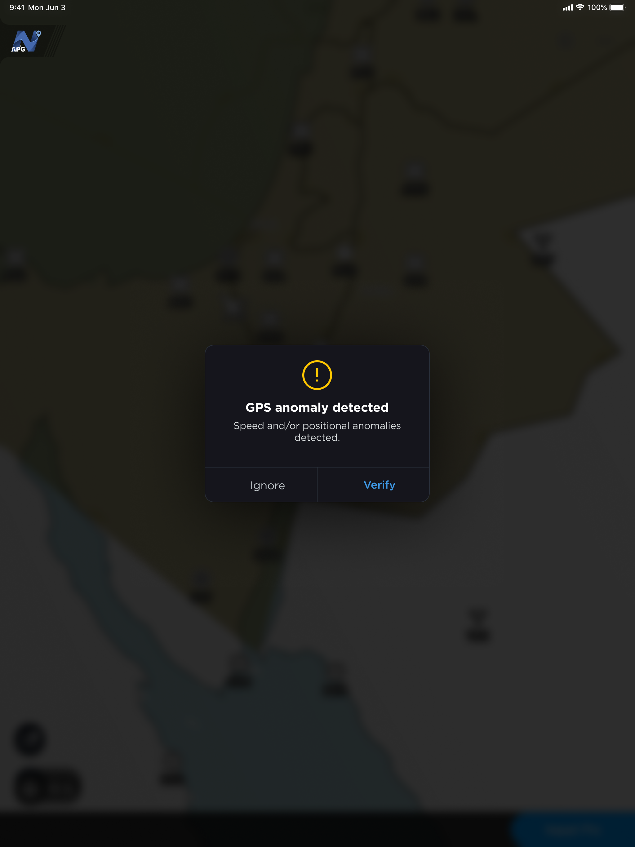
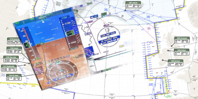
Since GPS Spoofing became prevalent in September of 2023, increasing numbers of aircraft are arriving at the Oceanic Boundary with one or both GPS sensors inoperative. A textbook GPS Spoofing encounter will initially see the GPS sensors rapidly change from the real coordinates to fake coordinates. If all GPS sensors agree on the fake coordinates, the FMS becomes confused. IRU values will increase, and in some cases, the IRS may also become “infected”.
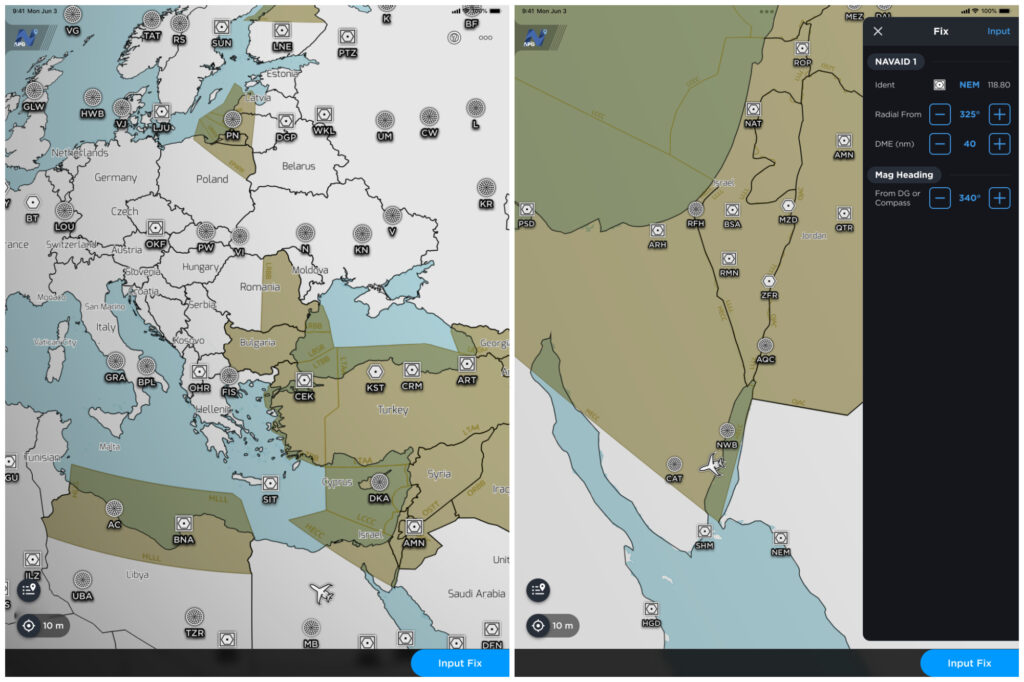
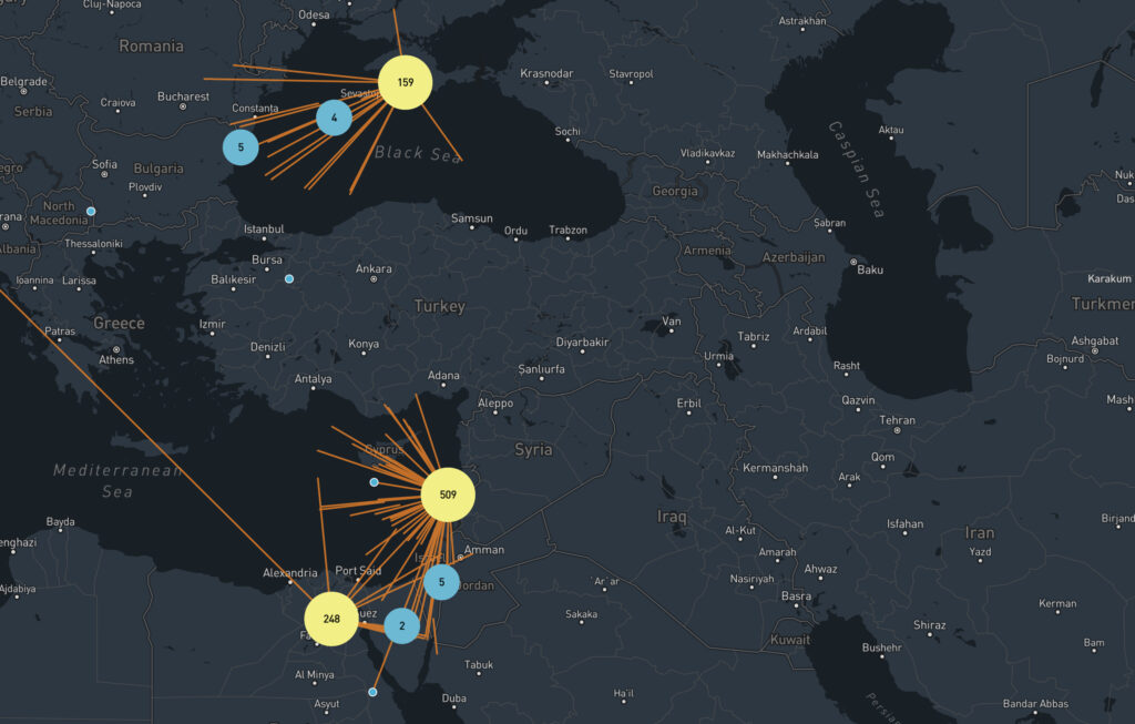
The primary spoofing locations have not changed much since the onset of the issue: you will encounter spoofing at the Iraq/Iran border, the Sinai peninsula area (showing Tel Aviv as the spoofed location), Israel and Cyprus (showing Beirut as the spoofed location), and the Black Sea (showing Sevastopol as the spoofed location).
We have no reports in OPSGROUP that the other type of GPS interference – GPS Jamming – leads to lasting effects. Once the jamming has stopped, aircraft systems are normal.
However, we do have reports that if GPS inputs are turned off before departure, and later turned back on in flight, that issues may occur. This is mostly reported for departures from Tel Aviv (LLBG).
GPS failure, Ocean approaching
Since RNP4 requires a functioning GPS, if you encounter spoofing and lose your GPS, you can’t fly RNP4. Assuming that you have an RNP10 approval (one of the only two options for the NAT HLA), you will become RNP10.
The problem occurs when Shanwick, or the OACC at the entry point, get late notice of this fact, and you are close to other aircraft. That leaves the Planning Controller with little time to figure out how to separate you (an RNP10 aircraft) from the others (RNP4 aircraft).
In some cases, “spoofed” aircraft have had to descend to FL280 to exit the NAT HLA, and this has caused diversions.
How to best handle a NAT crossing with a failed GPS
The key is to advise Shanwick, or the first OACC, early. Shanwick’s preference is that you use the RCL request to do this, and add a note to the end of the RCL along the lines of ATC REMARK/GPS DEGRADED RNP10 ONLY. If using voice to get your clearance, that’s what to say as well. Shanwick NOTAM EGGX G0106/24, and a note on the OTS Track message, has this information.
The RCL for Shanwick should ideally be sent 90 minutes before the Oceanic Entry in this case. Normal RCL timeframes are -30 to -90. An RCL sent any earlier will be rejected, but if you have something more unusual to discuss, you could use SATCOM to contact the supervisor and ensure a smooth crossing.
RNP10 time limit
With the change to RNP10 for your crossing, double check the time limit for RNP10. ICAO Doc 9613 (Volume II, Part B, Chapter 1) specifies that RNP is limited to 6.2 hours of flying. The timing starts from when “the systems are placed in navigation mode” or at the last point at which the “systems are updated”. The logic here is that the IRS will drift without updates enroute, and after 6.2 hours of flying, will no longer be capable of maintaining the RNP10 accuracy.
For an aircraft spoofed in the Mediterranean, or Black Sea area, it will take 4 hours before Oceanic entry, so this time limit becomes relevant. If the impact of the spoofing is severe enough, there is potential for inputs – including DME/DME or VOR/DME – to the IRS to stop working. This is one of the potential unknowns at present.
Shanwick comments
Shanwick are encountering several GPS jammed aircraft per day, and it is sometimes difficult (or impossible) to find optimum profiles for aircraft without moving several other aircraft to accommodate. The only instance where they have to insist on FL280 and below, is when an aircraft does not meet the requirements for MNPS (such as single LRNS), and needs to be cleared outside HLA.
If a pilot advises that they have lost RNP4, but are still capable of RNP10, Shanwick controllers will look to find a solution where the aircraft can be cleared with at least 10 minutes longitudinal and 60nm lateral separation. These aircraft also need coordinating with the next Oceanic Center before clearance, and sometimes there are limited options available.
In general, the earlier they informed about the degradation, the easier it is for the Shanwick controllers to find satisfactory solutions.
Member input
This is a developing issue and we gratefully welcome any input from members on this. Email us at team@ops.group.


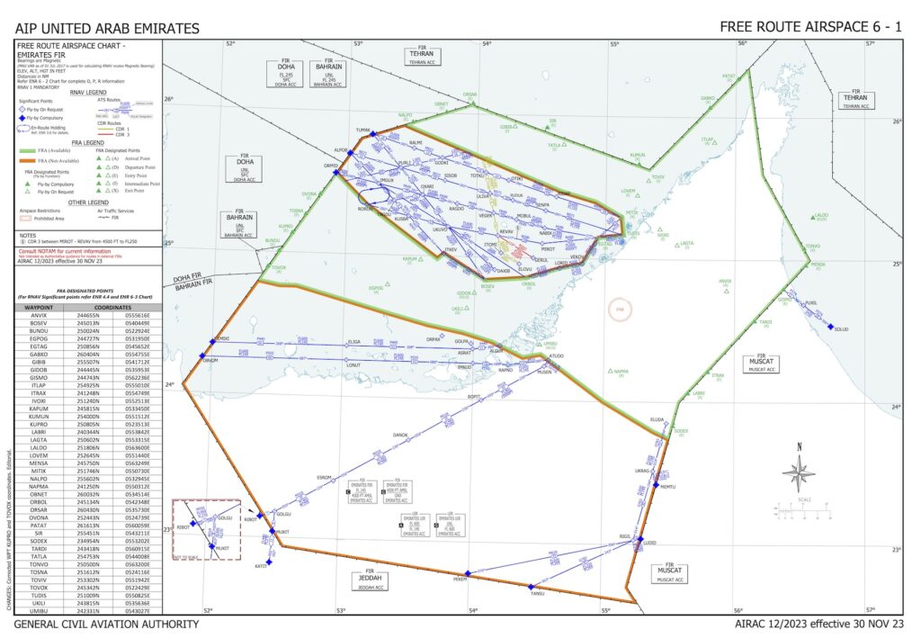
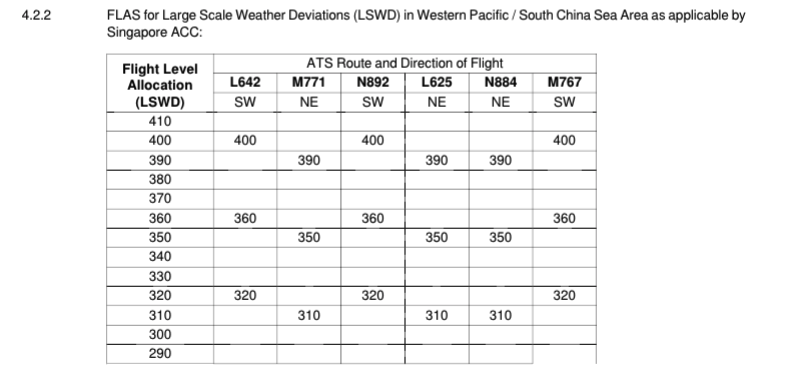 To make co-ordination easier between the numerous ATS sectors, all traffic operates with the same level availability whenever LSWDs are active.


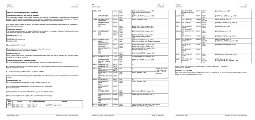
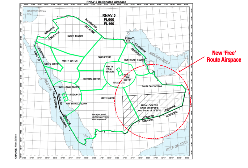 Typically, FRA means that pilots can freely plan any route they like between defined entry and exit points without reference to the ATS route network. This saves both money and time – simple.
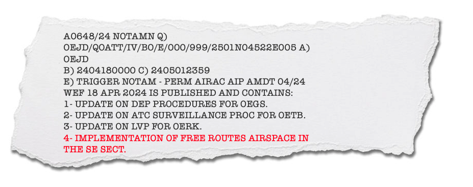 This directs you to the Saudi AIP. This is great if you have a spare half an hour to prove who you are, download a special app and access it. To save you the trouble, the relevant bit is ENR 2.2.4 which you can find