Three Ways To Escape From New York

Key Points
  • If you’re flying out of the New York area, expect delays. ATC staffing and tech issues, along with heavy traffic, are causing slowdowns.
  • But there are three lesser-known routing options (SERMN, Deep Water, TEC) that can get you airborne faster – if you’re willing to fly lower, carry extra fuel, and meet a few added requirements.

In the middle of last year, the FAA transferred control of Newark’s airspace from New York TRACON (N90) to Philadelphia TRACON’s Area C due to a shortage of staff.

And it hasn’t been smooth sailing. Philly itself is understaffed, and has reported several failures recently with data sent from New York via aging copper lines affecting both radar and communication equipment.

Recent murmurings from OPSGROUP members indicate EDCT delays are rife – even at outlier airports. We’re talking hours here, not minutes.

And in the short term at least, it looks like things will get worse before they get better.

The Memorial Day Weekend set records for US air travel, and the Summer peak is nearly upon us.

A couple of weeks back some clever folk from the NBAA, FAA and the Teterboro Users Group (TUG) got together to talk about the recent disruptions in the Northeast and what to do about it. You can view a replay of their excellent session here.

Some of the juiciest intel was the use of not-so-secret ATC routes to significantly reduce departure delays and get you clear of New York’s airspace post-haste.

In fact, three less conventional route options were discussed to help you escape the Big Apple.

A Quick Word on Fuel

A recurring theme here is ‘operational flexibility.’ None of these options will save you fuel, only time.

To use these routes, you will need to carry more. In some cases enough to operate at low level (less than 10,000’) for up to 100nm. But letting ATC know you are willing and capable of flying them may well see you jump an extremely long queue for conventional routes.

Escape Plan #1: SERMN Routes

When weather gets in the way of things, the FAA has a literal playbook of strategic options to help manage high volumes of traffic. You can find it here.

Within this playbook, is something called SERMN Routes. SERMN stands for SWAP Escape Routes – Metro New York. SWAP stands for severe weather avoidance plan. With me so far?

They comprise a low-level game plan to help ATC manage traffic out of the NY Metro area when the regular routes are not available due to nasty build-ups.

When this happens, ATC has three plays available (depending on the direction you’re headed):

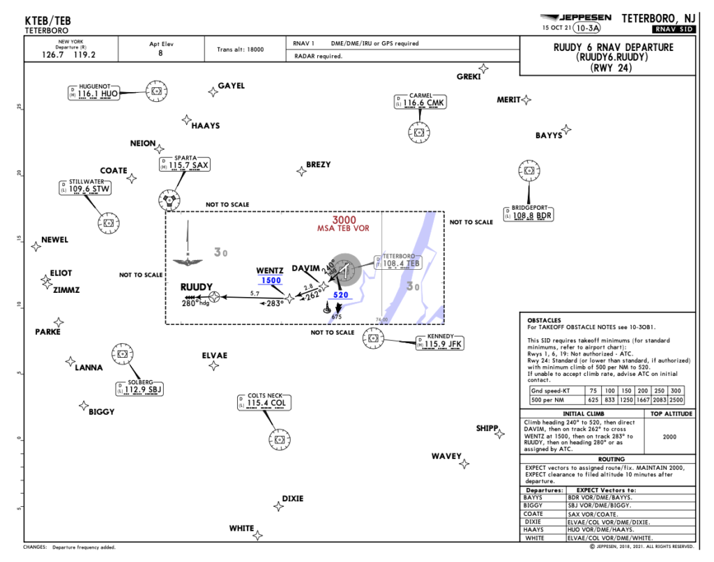
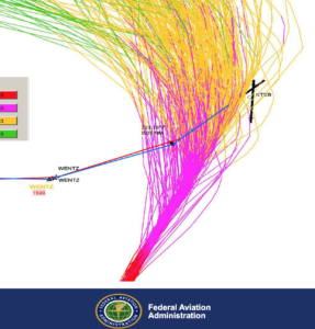
🏈 SERMN North (BUF, ROC, SYR, YYZ etc). Example routing ex KTEB: COATE → LAAYK → STUBN →BENEE → BUF→ KROC. Jets capped at 10,000′ until exiting NY  Center’s airspace.

🏈  SERMN South (DCA, CLT, ATL etc). Example routing ex KTEB: ELVAE → COL → DIXIE → T303 → LEEAH → T315→ TAPPA→ THHMP→ CAVLR6→ KIAD Jets capped at 8,000′.

🏈  SERMN East – (BOS, North Eastern Corridor). Example routing ex KTEB: BREZY → V39 → CMK → V3 → WOONS → KBOS. Jets capped at 9,000.’

Their aim is to get you under weather and away from traffic.

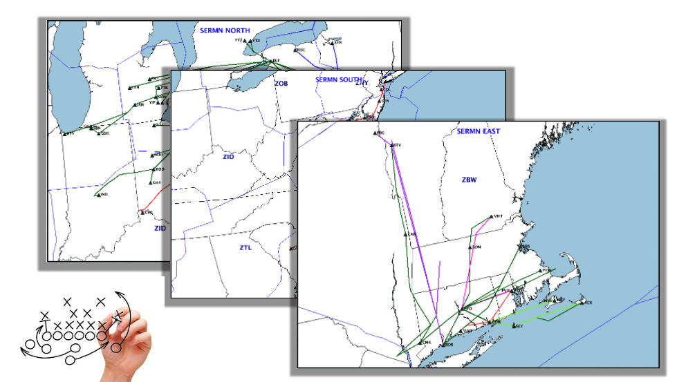
Click for the SERMN routes in the FAA’s National Severe Weather Playbook.

But here’s the kicker (football pun intended). You don’t necessarily need bad weather to fly em.’ If hit with a departure delay, communicate with Clearance Delivery that you’re fuelled and willing to accept a SERMN route. Or any of the other routes below (TEC and Deep Water) for that matter.

If you can get it, it may be good option to beat the crowds.

Hey, what about SERMN West?

It doesn’t actually exist, for a few reasons. Predominantly because western departures from the NY Metro area are heavily managed by other established routes such as J80 and J6.

Westbound traffic is also not as typically constrained by adjacent airspace as those aircraft headed in the other directions – and in any case there are other plays in the play book available for westbound traffic, they just don’t carry the title SERMN.

Escape Plan #2: Deep Water Routes

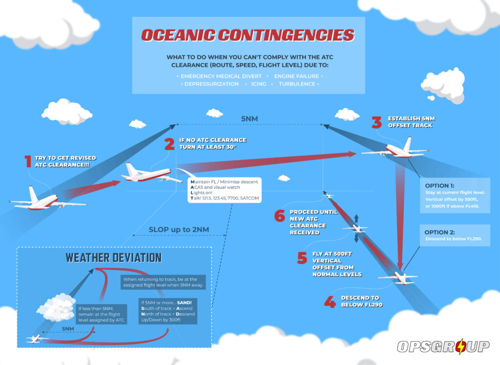
Another option to consider are Deep Water routes which run north and south off the coast between the Northeast and Florida.

If you have the right gear on board, don’t be afraid to get your feet wet.

The FAA advises they can be useful routes out of the area by getting you out of the way of traffic and restricted airspace along the coast.

But before you dive on in, it’s important you are familiar with the requirements of these routes to fly them.

For instance, in NY Oceanic airspace if you are not RNP 4 or 10 capable you need to let ATC know so that they can apply additional separation. If you do have RNP 4/10, you need to comply with those requirements which includes holding the appropriate Opspec/LOA and having the right equipment on board (such as two independent long range navigation systems).

And don’t forget your survival gear either – which can include lift vests, a raft, survival kits, an ELT and pyrotechnic signalling devices depending on what part of the law you’re operating under. You can find these under FARs 91.509, 135.167 and 121.339.

It’s also important you’re thoroughly familiar with the contingency procedures for oceanic airspace including what to do in the event of a navigation failure (especially loss of RNP capability).

Click for PDF.

Escape Plan #3: TEC Routes

If you’re not headed far from New York, consider the use of FAA TEC Routes (Tower Enroute Control).

These are low-altitude IFR routings (typically 5000 –  17,000’) used for short-distance flights (usually less than 500nm) and often link nearby metropolitan centres.

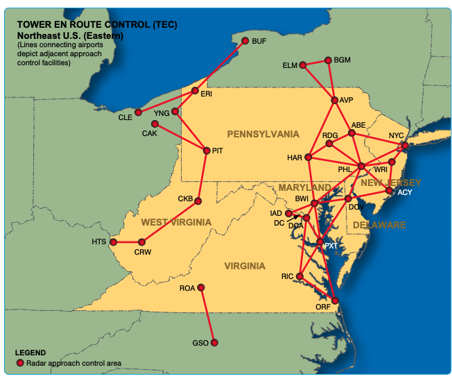
The idea behind them is to keep aircraft within TRACON (Terminal Radar Approach Control) without the need to hand them off to enroute centers. They are by design, simple and efficient.

These routes reduce controller workload, and keep you away from busier airways. They are typically used by turbo-prop aircraft, so let delivery know you have the fuel to fly them as they may not be immediately considered for jets.

You can find the NE TEC routes in the FAA Chart Supplement here.

Finally, stay clued in.

You can avoid delays by predicting when and where they are most likely. The FAA provides a head’s up via three useful sources – fly.faa.gov, nasstatus.faa.gov and X (formerly Twitter). This includes daily briefings on incoming weather, disruptions and the plans in place to mitigate against them.


Teterboro: RIP the RUUDY SIX

For some time now, the problematic RUUDY 6 SID out of KTEB has been causing trouble. In fact, just prior to the pandemic the FAA reported it had resulted in nearly two hundred pilot violations in just six years.

If you’re not familiar with it, it is a departure from Runway 24. Here’s the chart:

The reason for the high number of deviations is cause for debate with both lateral and vertical excursions reported. In the case of the latter, one suggestion is that the procedure itself isn’t that clear. For instance, a typical IFR clearance out of TEB includes the phrase “climb via the SID.”

Take another look at the chart – it requires a level off at 1500’ and an instruction to maintain 2000’.

This can be interpreted in two different ways – either to maintain 1500’ until cleared to 2000’, OR to continue climb to 2000’ passing the waypoint WENTZ.

The Teterboro Users Group (TUG) since clarified the latter is correct, given there are actually three things going on at once:

  • A turn to WENTZ to separate aircraft on Newark’s 22L ILS above.
  • A level restriction at WENTZ to keep aircraft away from aircraft descending to 2500’ above.
  • Achieving the minimum vectoring altitude for the area – hence the subsequent climb to 2000.’

And all of this while managing the energy of high-performance business jets shortly after take-off into some of the busiest airspace in the world. There is little room to get things wrong.

But people were, and quite consistently. And so, work began to develop a clearer SID to replace the troublesome RUUDY.

Welcome Wentz.

On July 11 that finally happened with the publication of the new WENTZ ONE SID – almost.

The WENTZ ONE is effectively an improvement to remove the ambiguity. It does away with the step climb to 2000’, instead requiring aircraft using it to maintain the one level – 1500’.

ATC will issue any subsequent climb instruction.

Here’s what the new procedure looks like:

Here’s the kicker though, while the charts have been published, no one is flying it just yet. Why?

TUG explains that this is due to FAA controller training requirements, which are essential. Given the pending relocation of Newark’s airspace from NY TRACON to Philadelphia TRACON it is difficult to predict exactly when this process will be finished.

So, while the plate will appear in your EFB, expect the RUUDY SIX for a short while yet.

What about an instrument approach to Runway 01?

While we have you here – there is another problem pilots need to contend with at TEB.

An instrument approach to Runway 01, or lack thereof.

Right now, the common procedure is the ILS 06, circle-to-land 01 to keep you clear of Newark.

This approach is challenging for a number of reasons. If you’re not familiar with those, check out Code 7700’s full briefing here.

For some time now TUG has been advocating tirelessly for a proper RNAV approach which is long since overdue. There has been some progress for some Honeywell users. Since last year there has been a coded FMS visual approach that replicates the visual to Runway 01, but with lateral guidance and vertical guidance using familiar waypoints DANDY and TORBY. It does this with moderate angles of bank and a gentle 3.5 degree slope alleviating some of the existing threats of the procedure.

You can watch that approach below:

With regards to a publicly available instrument approach to KTEB’s 01, TUG advises we will need to wait a while longer yet. They will have a formal update for us later this year.


New York ATC is grumpy for a reason

This started off as (and still really is) a very specific post just aimed at folk who operate into KTEB/Teterboro – because the runway 06/24 rehab project has begun!

So we copied all the information from the Teterboro User’s Group site and threw it into here. But then we realised the ‘problem’ with KTEB is that it’s very, very close to a lot of other bigger airports…

So if you operate into KEWR/Newark, KLGA/La Guardia or KJFK/New York Kennedy then we reckon it’s worth a read too. Because you might not realise what is going on underneath you and having an idea of the lay of the land (so to speak) is useful for that old SA we all harp on about…

So Teterboro is back in rehab?

They have a whole 11 months of works (to April 2023) planned for runway 06/24. Mostly it means closures, and these are pretty much all planned over night and on weekends.

Overnight closure timings:

  • Sunday, Tuesday, Wednesday, Thursday 22:30 – 06:30
  • Monday 22:30 – 08:30

Weekend Runway closure times and dates:

  • Friday 22:00 – Sunday 12:00 (until August 31)
  • Sunday 12:01 – Sunday 23:59 (until November 30)

Weekend Airport closure times and dates:

  • Friday 22:00 – Sunday 12:00 (July 1 until August 31)
  • Sunday 12:01 – Sunday 23:59 (October 1 to November 30)

But it is more than just the closures that you need to think about if you operate in here.

Arrival Stuff

Northerly Flow:

Depending on wind and weather, and what’s happening at KEWR/Newark you can usually expect an ILS 6 with a Circle to Rwy 1 or the RNAV (GPS) X Rwy 6

They are trying to bring in lateral and vertical guidance for Rwy 1. Watch this space. The circle to Rwy 1 is a nasty little thing so check out their guidance on it.

Departure Stuff

Southerly Flow

If its a southerly flow you can expect the Teterboro 4 SID which means delays.

Why?

Because they try to keep a 10nm gap between KEWR/Newark 22L arrivals and KTEB 19 departures. Which is why there is also the Dalton 2 visual departure (which only needs a 5nm gap).

Expect an infinite delay…

Well, that sounds bad. It doesn’t actually necessarily mean a lengthy delay though, particularly if you can accept the Dalton 2. The Dalton 2 keeps you down at 1,300’ and 180 knots in VFR until clear of all the KEWR traffic then you can expect a transition to an IFR clearance.

There is a meeting!

Yep, there is, on June 15 at 10:00 am EST. Organised through the Teterboro Users Group (TUG) which we strongly recommend you getting yourself in on if you do operate here and aren’t already in on it.

What else is going on down there though?

Well, like we mentioned, you’ve got several major international airports to consider as well, and some smaller executive airports and a military base. We counted and found more than 10 just in the immediate proximity to Teterboro.

KJFK, KEWR and KLGA have the dubious titles of ranking first, third, and fourth for worst delays in the nation. They are looking at ways to improve this, but most of them involve building more runways which won’t necessarily help poor old KTEB stuck underneath the every growing traffic flow.

Then there is the weather.

The east coast of the US gets hit with some pretty heavy storms. In April, a single day of bad weather saw over 4500 flights into the east coast delayed and the knock on effect across the busy airspace is considerable.


Big Changes Coming at East Hampton Airport

You may have heard the news. Long story short, KHTO/East Hampton airport is being de-activated as a public use airport, and then re-opened as private use only. The US FAA have given the plans a green light. A raft of new rules will come into effect on May 19 that will heavily affect how commercial operators can use the airport.

Here’s a rundown of what we know.

Wait, where?

KHTO is found 90nm-ish northeast of the Big Apple, towards the end of Long Island. The airport itself is well equipped, with two runways, jet fuel and an FBO.

The most common commercial traffic connects passengers with New York City.

It will close, and then re-open.

In January, East Hampton itself voted unanimously to convert the airport to private use only.

It’s going to close on May 17 for two days, and then re-open on May 19 subject to local control under the FAA’s ‘prior permission framework.’ Or in other words, there will be new (very) restrictive rules for commercial operators who want to fly there. Its ICAO identifier will change to KJPX on reopening.

Why though?

Simply put – noise. There have been years of complaints from residents, and even calls to close the airport completely.

So special flight procedures are being introduced to turn the volume down on ops there. Disclaimer alert: these are still subject to change until the official re-opening date.

How will the new rules work?

Prior Permission – All individual tail numbers will need specific approval from the airport authority first. Any commercial operator will also be restricted to only one return flight each day.

Noise Curfew – The airport will have new operating hours: 08:00 – 20:00 LT (Mon – Thurs), and 09:00 – 19:00LT (Fri – Sun). Outside of these times there will be no exceptions. They’re not mucking around either – any rule breakers will be banned from using the airport.

Noise Abatement – This will be introduced on all runways for both departures and arrivals, and at all times.

Weight Restriction – Aircraft with a MTOW of over 50,000lbs (22,679kg) won’t be allowed. Which rules out most Gulfstream and Global series aircraft.

New Instrument Approaches – Special IFR ‘M’ procedures will be put in place that operators will need specific permission to use. An FAA-approved third party is busy designing these, and they are expected to be published in time for the reopening on May 19. They won’t be publicly available via normal FAA databases though – you’ll need to ask first, but the good news it won’t cost anything. Applications need to be submitted the relevant FAA Flight Standards District Office.

The existing RNAV-Z approaches will be replaced for both Runway 10 and 28, but with fairly few changes other than minor design adjustments. Just don’t try and use the old ones.

What about blast off? – There will be no changes, existing rules will stay in place along with visibility and ceiling minima.

Where else can I go?

KFOK/Westhampton Beach is a good option at only 20nm away. Instrument approaches available, and the longest runway is 9000′ (2,743m).

For handling we recommend you contact Sheltair Aviation. You can reach them via fokcsr1@sheltairaviation.com.

Another options is KMTP/Montauk (but be aware of these gotchas: there’s no weather reporting, and no jet fuel available).

I still have questions, who can I call?

The East Hampton Airport manager, Jim Brundige on Brundige@EHamptonny.gov, or via +1 631 537 1130 ext. 5.

Please keep the team updated.

If you operate into KHTO under the new rules, we’d love to hear from you. There’s a couple of ways to get in touch – either by filing a spy report via Airport Spy, or by contacting the team directly on team@ops.group.


Testing Times At Teterboro: Closures and Challenges

Aside from being the oldest operating airport in the New York City area, KTEB/Teterboro is far from quiet.

In the good ol’ pre-Covid days of 2019 it saw over 124,000 aircraft movements – that’s 340 every single day. And even last year in the height of the pandemic, it was well on the way back to those levels.

It is also unique for a few reasons. The first is that it is weight limited – if your ride is heavier than 100,000 pounds (45,000kg-ish), then you can’t land there without a waiver. Which means there is no airline traffic, making it exclusively the realm of GA and business aviation operators.

It is also nestled among some of the busiest airspace in the world. The field itself is only 6nm from downtown Manhattan. Which means traffic in and out of there has to compete with the seemingly constant flows of nearby big hitters KLGA/LaGuardia, KJFK/New York, and especially KEWR/Newark.

This tricky combination creates unique operational challenges for controllers and pilots alike. And now things are going to get even more complicated. Here’s why…

A runway is off to rehab.

Or perhaps more accurately, Runway 06/24 is being rehabilitated. Which is a fancy way of saying it needs to be repaired.

 Unfortunately, this is also time consuming. So, a bunch of runway closures have been scheduled at KTEB running all the way into next year at night and on weekends.

During these closures Runway 01/19 will be in use for arrivals and departures which can be hugely disruptive to operations – especially in two scenarios:

Runway 01 Arrivals (Northerly Flow)

When Runway 06 is closed, arriving traffic can expect one of two approaches.

If the weather is good.

 You can expect the ILS approach runway 06, circle to land 01 to keep you clear of Newark. But beware, it can be a challenging approach for a few reasons. Code 7700 has published a fantastic briefing that is almost a compulsory read if you’re unfamiliar with ops there.

Some other common sense prevails too – make sure the approach is carefully briefed beforehand. It’s tight, and easy to get unstable so crew co-ordination is going to be important to keep the old SA up.

If the weather is not so good.

You can expect an RNAV-X approach onto Runway 06 – runway closures are weather dependent. The Port Authority of New York and New Jersey have confirmed they will open it back up.

When are we going to see an instrument approach for Runway 01?

 Good question, the problem is that Newark gets in the way again. The Teterboro User’s Group are hard at work with the FAA to come up with one, but the process is by nature slow. Within months is the goal, but not quite soon enough to help during these works.

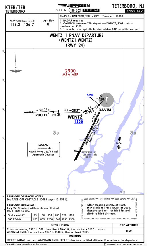
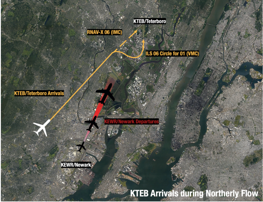
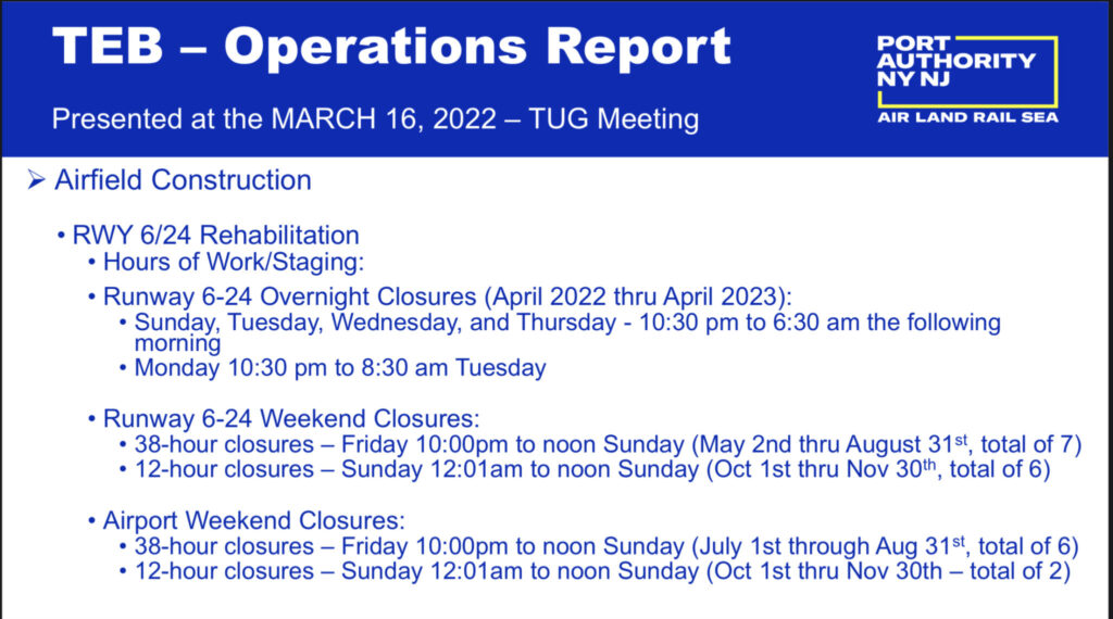
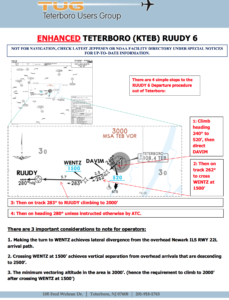
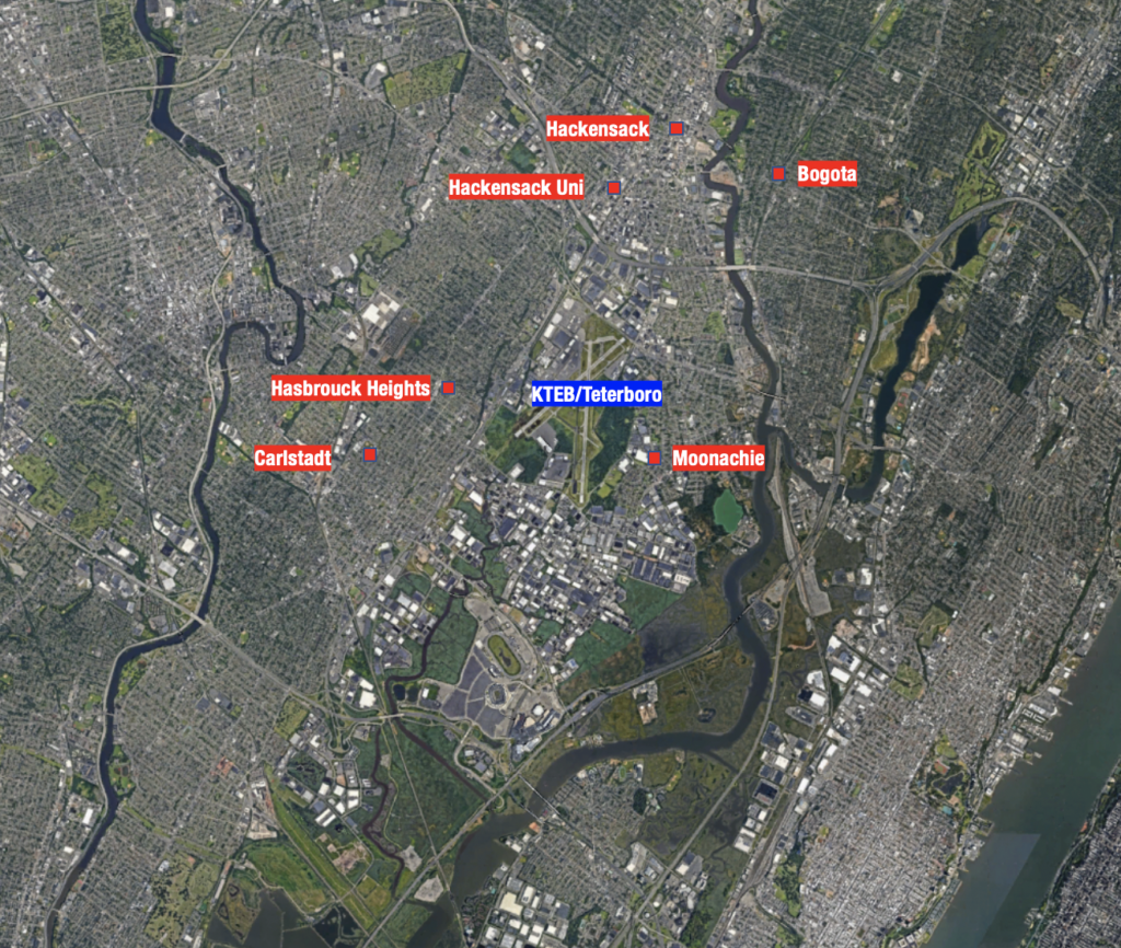
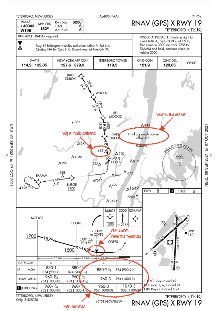
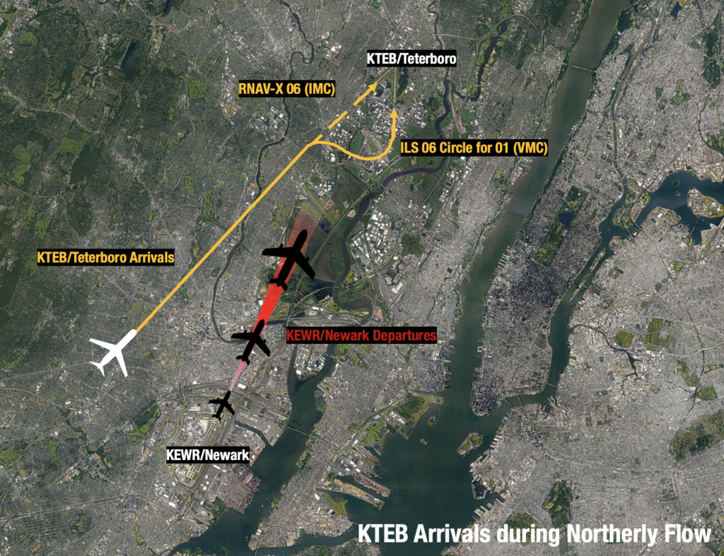
Runway 19 Departures (Southerly Flow)

This is when you can expect big delays, as Runway 19 points straight at Newark.

Expect the Teterboro 4 Departure by default. But a head’s up – for every single aircraft that launches out of Teterboro on this SID, NY TRACON needs to find a 10nm gap in arrivals at Newark. And that means a lot of waiting. There may be a better option…

Consider the Dalton.

The what? The Dalton Two Departure. It’s unique because it allows aircraft to depart Teterboro visually, before transitioning to your IFR flight plan – and it’s by pilot request only when the weather is better than 3000 – 3.

The Teterboro User’s Group worked with the FAA to get this one off the ground (no pun intended). It is essentially a right-hand turn after departure onto a westerly heading, at or below 1300 feet. You’ll need to keep your speed back too.

The spacing required is effectively halved. Don’t be put off by the phrase expect indefinite delays either. It’s ATC’s way of telling you they don’t know how long it’ll be. But local operators confirm delays are never worse than the standard TEB 4, and more often than not, better.

But before you light the fires, there are a couple of gotchas. It’s going to get busy – the low level-off happens quickly in high performance jets, especially at light weights. So be ready for it. Also, the westerly heading points you (visually) towards rising terrain and there have been reports of EGPWS warnings as a result.

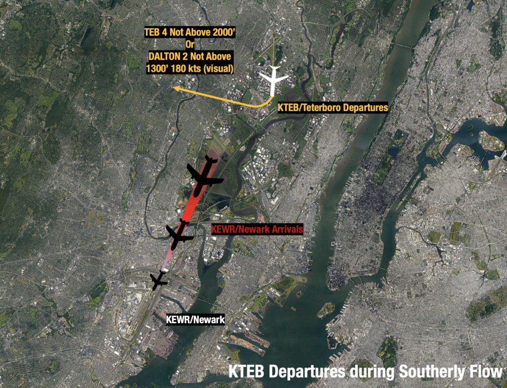
Teterboro isn’t the only option.

If you don’t have the appetite for all of this and are looking for more straight forward options, here are a couple to consider:

KHPN/White Plains It’s 25nm from Manhattan – about a 40-minute drive in normal traffic. It has two runways, the longest being 6549’ (1996m) long.

KMMU/Morristown About the same distance away with a slightly longer 50-minute drive. It also has two runways with the lengthiest option of 5,998’ (1,828m).

Local operators in New York have told us that even though the drive is a little longer, the overall travel time is often less when you avoid delays in and out of KTEB.

Look out for full airport closures too.

There are also eight complete airport closures scheduled for KTEB coming up, some lasting up to 38 hours: 

July 1 – August 31: Six closures are planned on weekends, from Friday 10pm until Sunday 12pm (local time).

October 1 – November 3: Two closures are planned from Sunday 12:01am – 12pm (local time).

 The exact dates will be confirmed by Notam.

Need more support?

Reach out to the friendly folk at TUG (the Teterboro User’s Group). They’re experts on ops at KTEB, they post weekly construction bulletins on their website and are more than happy to help operators out with advice. Also a special thank you to David Belastock – the President of TUG. This write up would not have been possible without his experience and generous support of OPSGROUP.

We made an Airport Lowdown for KTEB a while back, which you can see here. We had help (since we’ve never flown in there), but if you spot anything to add or change then let us know.

Or you can talk to the OPSGROUP team directly on team@ops.group. We’d love to hear from you.


What’s the news at Newark?

KEWR/Newark Liberty International is the other, other international airport serving the New York metropolitan area – the busiest airport system in the US – along with KJFK/New York JFK and KLGA/La Guardia.

Whilst JFK airport is the largest, Newark is actually the busiest in terms of number of flights. It is also the 6th busiest airport in the US in terms of international traffic, and 15th busiest in general in the country.

So, what is happening now?

Runway works. And a general redevelopment program which includes a plan to replace Terminal A, due to be fully finished by 2022. You can read about that here.

But it is the runway rehabilitation we are most interested in, because it involves runway 04R/22L. The runway was last upgraded in 2012 so this is long overdue, particularly given that it serves 47 percent of the airport’s traffic load.

Of course, there is a Notam to warn everyone about the closure.

Does anyone remember AC Flight 759?

Air Canada Flight 759 is the one that, in 2017, very nearly had a very nasty accident at KSFO/San Francisco. By very nearly, we mean avoided it by less than about 14 feet. That was the reported distance between the bottom of the Air Canada aircraft and the tail of a Phillippine Airlines A340 sitting on Taxiway C.

One of the probable causes the NTSB cited was the pilots mistaking taxiway C for runway 28R because they had overlooked the closure of runway 28L in the Notam report.

So, let’s take a look at the Notams you will see for KEWR/Newark should you operate in there today.

We downloaded a report straight from the FAA Notam site, and it is here if you would like a look.

This may well differ to what you would receive in your flight plan pack, we have not included any filters and the layout is a little less user friendly. It is possible your flight planning department / system / whatever you use does present this in a clearer way, but it is also possible it does not.

We had this highlighted to us by a member whose exact words were “Talk about getting lost in the weeds – that’s just crazy.”

So, what is the concern?

Well, there are 5 pages, with 108 Notams in total and hidden away on page 4 is Notam 07/045

Which is why we mentioned the KSFO incident.

Newark’s runway layout looks like this – 

San Fran’s runway layout is this –

And while KSFO’s layout, with taxiway C to the outer side of runway 28R led to a more likely visual mistake, the mixing of this Notam within a swamp of over 100 others does mean it might be missed, particularly by an operator who is not familiar with the airport.

Notam 07/045

The Notam advises that runway 04R/22L will be closed from 06 July 2021 until 01 October 2021.

There is, if your filter includes it, also a construction plan.

What about the other 107 notams?

Nothing can substitute flight planners and pilots reading the Notam packs thoroughly. However, faced with 108 Notams for an airport (especially if you’re not familiar with it), it might be daunting.

So here is a summary of what to look out for, (as of September 15 2021).

In the air:

  • Rwy 11 has PAPIs but no VASIs. The visual glide slope indicators should not be used as they do not coincide with the ILS of RNAV glide paths
  • There are a lot of  VORs which have been permanently taken out of service, but many of the arrivals and some of the missed approaches require them. If you don’t have a suitable GPS equipped RNAV system then you are not gong to be able to fly a fair few arrivals and departures to the airport, or the ILS or VOR DME approaches for runway 11
      • TEB, COL, CRI, OTT, SBJ
  • The ILS and the LOC/DME procedures for 04L are not available
  • You cannot circle to runway 29 or 11 at night. The RNAV visual for 29 is also unavailable
  • There are a lot of cranes in the area. Some as high as 150′
  • The approaches for 04R/22L are not available… probably because the runway is closed
  • Runway 04R/22L is closed

On the ground:

  • A lot of the ground markings are faded so watch out while taxying.
  • The centre line markings for 11/29 are also in pretty poor condition. Actually, a lot of lead off lines and other runway markings for the other runways are faded too
  • And a lot of signs are missing or are missing lights, or are non-standard. So a general caution while on the taxiways.

Any other notices to know?

There is a long list of Letters to Airmen published for Newark. If you have not been there before, or seen these, then they are worth a read because they give helpful info on operations for the airport, and for the general NY area.

LTA-EWR-47 highlights the procedures for engrossing and egressing the ramp. So in plain English, entering and exiting. If you have just arrived then call ground control with your ramp entrance once you’ve crossed 04L/22R. If you’re departing then let ground control know which ramp exit you want when you request your taxi clearance.

LTA-EWR-44 talks about the big Hotspot at the end of 22R/04L. A lot of GA flights make the mistake here. You’re going to be told to taxi PAPA, cross runway 11 then turn left on SULU and hold short runway 04L”. The turn is tight and the hold short is right there so don’t go too far!

And the others…

  • LTA 51 is warning operators about non-visible areas – basically where ATC can’t see you so be extra careful of other traffic.
  • LTA 45 says be ready for takeoff when cleared, don’t dawdle on the runway.
  • LTA 46 is about helicopter departures.
  • LTA 48 is your info on LAHSO.
  • LTA 49 warns that ATC might issue multiple runway crossings using various different taxiways. Watch out for other traffic, but its not a race!
  • LTA 50 is all about line up and wait clearances at night.
  • LTA 52 is about simultaneous intersecting runways ops for arrives to 4Rand 29 – and the fact ATC are allowed to do it.
  • LAT 53 is your available distances for intersection departures.
  • LAT N90-67 warns to watch your climbs and descents in busy NY airspace.
  • LAT N90-73 It is really busy and aircraft often get vectored in and out of Class B airspace. This lists the airspace “hotspots” for traffic in the areas surrounding each major airport.

Any other things to share?

Aircraft are reporting they have been given the Stadium Visual when heading in from the North. One to look over if not familiar, particularly if you’re not familiar with visual approaches and are expecting a nice straightforward ILS of some sort.

We only have one Airport Spy review for KEWR/Newark and yet it is a challenging airport in a challenging region where we know a lot of folk have flown. So here is our call for your operational hints and tips!

If you are familiar with KEWR/Newark then please share those “gotchas” or need to know “heads ups” – and we will share them on to everyone in the group. You can file an Airport Spy report here: ops.group/blog/spyreport


Changes at Teterboro: What you might have missed

The skies over New York have been quieter over the past year or so, and it’s not hard to guess why. With lower traffic levels, there have been a number of operational changes at nearby KTEB/Teterboro. Here’s a rundown of what you might have missed recently…

Noise is a bigger issue than ever

It may seem ironic, but Covid hasn’t helped. With less airplanes in the skies, nearby residents have become more aware of Teterboro’s noise, and complaints have been on the rise.

If you’re headed to KTEB, be aware that there are extensive noise abatement procedures. There’s a handy summary of these available online, but here are some of the biggest gotchas to get you started.

If your ride is a jet and you’re new to KTEB, you’ll need permission first. There’s a form to fill out for that.

The most noise sensitive time is between 22:00 and 06:00LT, and it’s when you’re the most likely to get yourself into trouble. There’s a ‘voluntarily restraint’ in place after 23:00  – in other words if your flight isn’t essential, it should wait.

Sprinkled through the surrounding suburbs are noise monitoring devices, and there are strict decibel limits. The most restrictive is Runway 24 at night (only 80dB). Bust em’, and you can be served a violation – too many of those and you can say sayonara to operating there. And they take two years to expire.

The least noise sensitive area is to the south of the airport. So if departing on the back of the clock and the weather is playing ball, try to use Runway 19 for departures and Runway 01 for arrivals.

Speaking of noise, the new RNAV X RWY 19

Back in July, an offset RNAV noise sensitive approach was introduced for Runway 19. It’s a quieter alternative to the straight-in ILS. It’s recommended for night ops at KTEB on request (and you may hear it mentioned on the ATIS). But there’s some important stuff you should know before you go ahead and shoot it.

If conditions are less than ‘tropical’, keep in mind the approach is significantly offset (13 degrees) and minimas are high. The visual descent point is almost three miles from the threshold. There’s also a big unfriendly radio antenna at the business end of the approach. At the VDP on the correct 3 degree path, you’ll be uncomfortably close to it – check out this article for just how close.

What’s the moral of the story? In marginal conditions, the approach can quickly become challenging – consider the ILS if in doubt.

Escape Routes

Tired of waiting at the hold? We don’t blame you!

There are new departure routes to help business jet operators get airborne out of KTEB when the weather is bad, or New York’s majors airports are especially busy. New York TRACON is responsible for co-ordinating those with the tower.

A head’s up though – they are designed with the performance of business jets in mind and may require steeper climb profiles than you’re used to.

You need to fly them from start to finish too. Don’t accept the clearance unless you are sure you can meet the requirements, and asking for track shortening after wheels up is a no-no.

Works

Construction and runway maintenance are ongoing. Single runway closures are common and can happen during the day. The good news is that full closures are pretty rare.

Something to look out for – if Runway 06/24 is closed in southerly conditions, extended delays are common at KTEB due to the flow at nearby KEWR/Newark, just 10nm to the South. You might need to carry some extra gas.

The Teterboro Users Group publish weekly Maintenance Bulletins for Runway and Taxiway closures which you can access here. Of course, if you prefer your info capitalised and abbreviated, you’ll find the information in  Notams too.

Covid

We’re all well over it. But there are some procedures to follow, especially if operating an international flight into KTEB.

US Customs and Border Protection are up and running at the airport, but will only accept international arrivals between 07:15 and 23:15 local. Don’t show up after hours. Standard CDC rules apply here including the pre-travel testing requirement for all pax.

For a full break down of these and other health protocols, you can view a full rundown here.

Have we missed something?

We’d love to hear from you! You can reach us at blog.team@ops.group.

Also check out our recent Airport Lowdown for KTEB/Teterboro – it’s the biggest threats all in one place, built by pilots who have been there.


Escape From New York: How To Get In & Out of Teterboro (2019)

There’s nothing that will drain a smartphone battery quicker than a ground delay in Teterboro. Preflight complete, flight plan loaded, passengers onboard (they were actually on time for a change), engines started and – wait for it – you are instructed to contact “ground metering.” The word itself can make the stomach drop.

Yes, a line of thunderstorms is moving in, but it’s not quite solid. Most of my route does not look affected, but far better minds than mine have determined that diverting traffic require them to close my entry gate, as well as most of the surrounding ones. I receive an Expect Departure Clearance Time (EDCT) of over three and a half hours away!

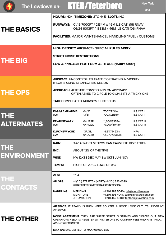
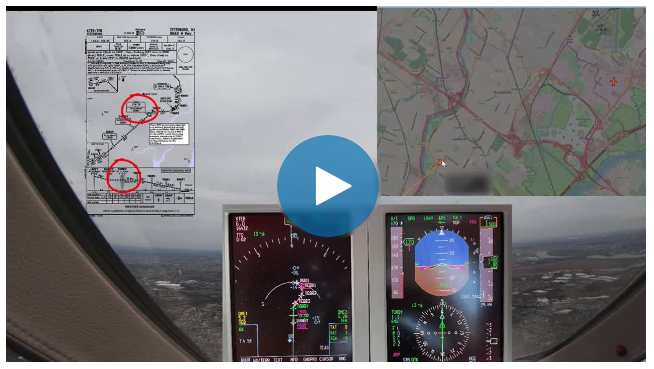
Normally I make it as far as taxiing just short of TEB’s RWY 24 before the controllers present me with such a lovely ground delay and instruct me to park in the “penalty box.” This time I hadn’t even left the chocks (I wasn’t even actually supposed to start the engines before contacting “metering”, but of course I didn’t admit that mistake to the controller).

Ground delays due to weather or traffic saturation are not uncommon in Teterboro. We have to hand it to the Teterboro ATC staff for efficiently controlling one of the busiest GA airports in the world (about 174,000 arrivals a year). They not only deal with all the complications that come with being located under some of the most congested airspace in the world, they patiently work everyday with a bunch of A-list pilot personalities that think their schedules are more important than any delays. Well done, you ninjas of New Jersey!

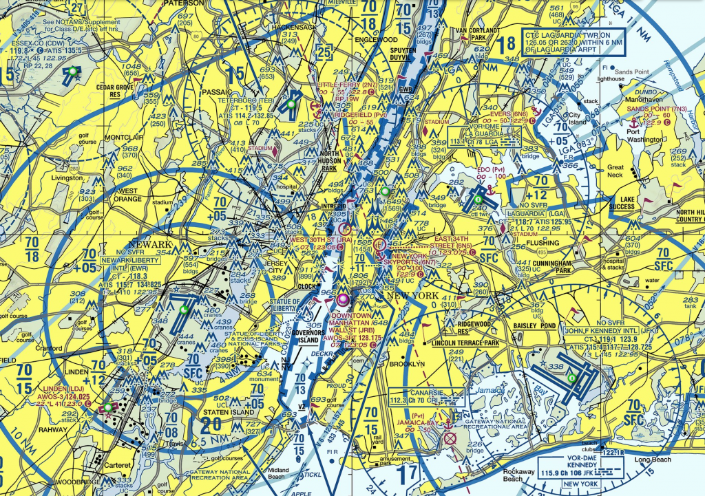
Weather, traffic and pilots aren’t the only issues they’ve been dealing with lately. Improvement projects have been steadily grinding along for the past year and a half. And guess what? There’s even more to come!

So, after I inform my passengers of this delay, allow me to hop back up in the cockpit and let’s discuss some Teterboro info with the help from our good friend Dave Belastock, President of the Teterboro User Group. Perhaps you heard him speak on the latest OpsChat, but, if not, we’re going to dive in a little deeper.Oh, by the way, don’t be offended while I analyze my fantasy football scores on my phone; I’m a multi-tasker, and we’ve got three and half hours – well three now – to go and I’ve got 85% battery life on my phone left.


EDCT: T minus 3:00, battery 85%

The Entry

Getting into Teterboro can often be a frustrating game. When calling for a clearance at your departure airport, wagers can be made that an EDCT will be issued. Gone are the days in which operators would file a nearby airport (KMMU/Morristown, KHPN/White Plains, etc.) and change the destination to TEB enroute to avoid such ground delays. I’ve never tried it, but I did witness a former chief pilot broach the subject with clearance delivery at a Midwestern airport about attempting this. “If you to try that stunt, I’ll route you through Florida,” was the controller’s response.

But getting the heads-up on delays may depend upon early filing. The FAA’s Traffic Management Unit coordinates the flow programs into airports experiencing delays. According to one TMU official, “Get your flight plan filed prior to program implementation (at least a day in advance) and try not to change that proposal time. The command center ‘optimizer’ computer will issue releases/slots based on those times. And your flight plan won’t drop out of the system until 2 hours after your EDCT.”

I’ve had service providers tell me that the earlier you file, the higher up you are on the departure list. I never knew if this was true or not, but it may look like it certainly has a partial effect.


EDCT: T minus 2 hrs 30 mins, battery 67%.

Upon arrival into Teterboro, you will watch your TCAS light up like a Galactica arcade game, especially on a clear day. Glider activity near the MUGZY waypoint on the LVZ STAR to the northwest and GA traffic from multiple small airports flock below you. And the question usually comes up once you are beneath Newark’s Class B airspace: “What speed should we be going?”

The answer is of course 200 knots. But more than once I have been angrily asked by a controller what my speed was and, after answering 200 knots, speed reductions were quickly mandated to traffic following behind me. Thus, there was a perception that NY Tracon needed you to keep your speed up into TEB. But no controller may authorize an aircraft to exceed 200kts under Class B. If it makes you feel better to report your speed reduction, be my guest. But the answer is 200kts.

Those familiar with TEB approaches understand that you must certainly be on your game and brief your approach. The ILS RWY 6, including the circle to land RWY 1, has a mandatory altitude of 1500 feet at DANDY that pilots are still not making before intercepting the glide slope. The circle procedure can be tricky, especially with a tall antennae to the south of the airport. And if winds are gusty from the northwest expect turbulence from the distant hills. In 2017, a Learjet became unstable during this approach, stalled and crashed as the crew were unprepared for the approach. Early briefing and proficient monitoring will ensure a safe and simple approach.


EDCT: T minus 2 hrs, battery 50%.

Belastock mentions that a new RNAV GPS RWY 19 with LPV mins is expected to be published in December. Some aircraft flying a coupled ILS RWY 19 with the localizer captured at 2000 feet have experienced an uncommanded climb due to a false glide slide capture. This glide slope perturbation is triggered by aircraft moving on taxiway Q across RWY 19 and passing in front of the glide slope antennae, which briefly deflects the signal downward enough to satisfy capture parameters. Once the taxiing aircraft has cleared the glide slope critical area, the beam returns to its proper angle. If you have Approach mode armed, the autopilot may grab the temporarily deflected glide slope and then pitch up when the signal returns to normal. Close monitoring and quick action are required to prevent an altitude deviation. The GPS approach would circumnavigate this potential issue.

And speaking of that turn between UNVIL and TUGGZ to intercept the final approach course, you could very well see VFR aircraft just below you. You are outside Class D airspace at that point so separation requirements aren’t necessary. While other NY area airports have communication requirements for VFR traffic transitioning near congested airspace, TEB has none. TUG is currently working with the FAA to create a Class D transition area to the north to require communication. Fingers crossed.


EDCT: T minus 1hr 30 mins, battery 42%.

The Escape

RWY 6-24 is going to see substantial improvement in 2020. Currently, the plan is to close the runway several evenings through the summer, starting the day after Memorial Day through Labor Day. “Port Authority of NY and NJ staff have worked diligently to create a schedule that would least affect operators,” explained Belastock. “We are anticipating RWY 6-24 to close from 10pm Saturday nights until noon on Sundays. And then there will be two 24-hour closures beginning at 10pm Friday through Saturday night at dates to be determined.”

This will inevitably switch up the normal departure procedures. Whereas the RUUDY RNAV departure (we’ll discuss good ol’ RUUDY in a second) is the traditional departure, the alternative will be the DALTON 2 departure.

“Do you ever wonder why you have to hold short of RWY 24 for an extended period of time waiting for an IFR release?” asks Belastock. “That’s because NY Tracon requires a 10nm separation between you and the overflying Newark traffic.” The Dalton departure, however, is a VFR-IFR departure.

VFR? Really?

Yep, just as the instrument departure plate reads, aircraft depart VFR – 3 sm visibility and 3000’ ceilings are required – and when handed over to the departure controller, the IFR flight plan is activated. Theoretically there is no gap required between the VFR Teterboro departures and IFR Newark arrivals. But consideration was taken between all stakeholders, and a 5nm gap between TEB and EWR traffic was agreed upon. “TEB clearance can’t solicit the departure. You must request it and have a published departure plate available in the cockpit,” said Belastock.

Though this could mean a reduction in release time, if there is a delay in progress controllers can only offer an “indefinite delay” for traffic or weather issues, whereas they can give you a set time if using the other IFR departures. “Actually, NY Tracon is encouraging it. They want pilots and controllers comfortable with it,” said Belastock.

As for the RUUDY RNAV departure, good news! Pilot deviations are decreasing. Belastock and TUG worked closely with training facilities as well as OPSGROUP to get the word out. I even noticed the RUDDY departure was included in my latest recurrent simulator training. With the altitude restriction and noise abatement restrictions pilots need to be extremely situationally aware. “We don’t want to tell pilots how to fly their aircraft,” said Belastock. “But we need them to be fully aware of how the departure operates.”


EDCT: T minus 1:15, battery 37%.

The Window of Opportunity

My eyes are burning a bit from so much screen time on my phone. I query Gate Hold again – just like the other 73 pilots that are trying to chime in. Yep, that’s me you’re rolling your eyes at.  My EDCT time is actually extended further even though the weather is past my entry gate. “Is there anything we can do to get out of here,” I reply with a frustration.

“Can you fly a final altitude of 14,000 feet?”

Confusion mixes with a sense of impending opportunity. “Standby,” I answer. I always take extra fuel out of TEB, but I’m sure there cannot be enough to fly that low. I run the numbers…and, I’ll be damned, we can make the destination with a safe fuel reserve.

“Actually, yes we can,” I reply excitedly. “Start your engines and contact ground control,” comes the reply. As I taxi past all the other waiting aircraft, I couldn’t help but feel a sense of guilt…and some pleasure as well.

We departed on the RUUDY departure, flew west while climbing to 14,000 feet talking to NY Center and several approach controllers. When we were handed off to Cleveland Center, we requested a more appropriate cruising altitude and given it without question.

I later called TEB tower to see how this “gift” actually occurred. “It doesn’t happen often. But since your entry gate and route were getting so saturated with diverting traffic, you couldn’t fly it at your filed altitude. But this wasn’t the case for the lower altitudes,” explained the controller. “I can’t offer it unless you specifically ask. But even then it probably won’t be granted.”

I’ve been flying in and out of TEB for 15 years, and I’m still often learning new details about its operation. Perhaps I’ll keep this tool in my back pocket for the next great escape.


Two is Not Enough: New NAT Doc 007 (Version 3) – August 2019

NAT Doc 007 is the Bible of the North Atlantic. It’s full of NAT goodness – all the specifics about how to operate your aircraft safely through the complex airspace of the region is here.

And there’s another new edition!

The NAT changes over the last few years have been coming thicker and faster than the sandwiches at Katz’s Deli on the Lower East Side. And now, there’s more. Effective August 7th, 2019, NAT Doc 007, Version 3, is the latest tome to digest. As aviation documents go, it’s written in pretty digestible language. There’s just a lot in it. But this is the first time we’ve had 3 editions of this in one year.

So, we’re going to start naming them after 007 Movies to keep track of them all. This is the “Two is Not Enough” edition.

NAT Doc 007, Version 3, 2019:
Download the full NAT Doc 007.

So, here are the three things that have changed this time:

1. We got new SLOP rules! This is a biggie. Instead of the three previous choices (0, 1, or 2nm), we now have Twenty One choices! More on this below.

2. 99 problems and Datalink is one. The short version: check that you’ve got the latest software update for your datalink.

3. The next datalink mandate (2C) is capped at FL410. This comes in January 30th next year. And so, the Checklist for Dispatchers is updated.

The new SLOP rules

Now, let’s take a closer look at the big change – SLOP (Strategic Lateral Offset Procedure). To get up to speed, check out our full article on SLOP – the how, and why (and where).

The change here is that instead of just being able to SLOP 1 or 2 nm right of track, (or fly the centreline), you go from these three choices to twenty one – you can use any one of 21 Micro-SLOP offsets. Specifically: 0.0 nm, 0.1 nm, 0.2 nm …. OK, you get it. All the way up to 2.0 nm Right of track.

Simple, right?

Not quite. It’s not yet fully clear which of the OCA’s have given the green light for this, even though NAT Doc 007 now says you should Micro-SLOP if you can.

But, phoning around the Oceanic Houses, we’ve got this to tell you:

1. Gander – you can micro-SLOP right now! An AIP amendment will follow soon.
2. Shanwick – you can micro-SLOP right now! A Notam will be published soon, and the AIP will be updated in Dec 2019.
3. New York – they will allow micro-SLOP from 12th Sept 2019, and will update the AIP in Jan 2020.
4. Santa Maria – you can micro-SLOP right now! Nothing published officially yet, but that’s what the good people from the oceanic control centre have told us.
5. Iceland – just like New York, they will allow micro-SLOP here from 12th Sept 2019 as well. When that happens, you will still not be allowed to SLOP below FL285 within the Reykjavik CTA (that’s the domestic part over Iceland, and the airspace over Greenland above FL195). We asked them to publish a Notam about this – and they actually did!! Check it out!
6. Bodo – Nothing official yet, but ATC say they “have no objections” to operators micro-SLOPing right now. (Currently, SLOP is only allowed here above FL285 within the OCA.)

That’s the current picture as of 1100z on Monday 19th Aug.

We will update this as soon as we get more info. Got something for us? Email us!


FOCM: Flight Operations Coffee Morning

OPSGROUP is hosting the first FOCM in New York City on June12th, and we’d love you to come along.

FOCM – Flight Operations Coffee Morning – is an OPSGROUP event where you can meet other pilots, dispatchers, controllers, and Ops specialists, hang out, have a coffee, and talk flight ops.

Dave and Mark from OPSGROUP, will host a quick Q&A about International Flight Ops, and our work as a group. We’ll talk NAT Tracks, Ramp Checks, Flight planning, Airspace Risk, Notams, the latest challenges – and what we can do to make things better.

And you get to meet and connect with other people working in Flight Ops in New York, New Jersey, and beyond. We’ll have A380 Captains and Gulfstream FO’s, Corporate dispatchers, New York ATC, and a bunch of other good people.

OPSGROUP is a collective of 5000 pilots, dispatchers, controllers, and ops specialists that work together to share information and resources, making flight ops simpler and safer. We’re hosting this because we love connecting people. It’s totally free.

Event details

When: Tuesday June 12th, 2019
Where: Lower East Side, NYC – address on RSVP
Cost: None!
RSVP here: https://focm.splashthat.com/

PDF Flyer – Print it out!

Why are you still getting the Ruudy6 wrong? Stop at 1500!

If you’re departing Teterboro any time soon, make sure you stop at 1500 feet – and have a good look at the rest of the RUUDY 6 departure. That’s the message from NY ATC, and the Teterboro Users Group.

The FAA has reported over 112 pilot deviations on the KTEB/Teterboro RUUDY 6  SID.

The Teterboro Users Group has asked us to remind all pilots that strict compliance is required, especially vertically.

“The most common error being a climb straight to 2000’ without honouring the requirement to cross WENTZ at 1500” – Capt. David Belastock, President, TUG

This week the FAA issued the following notice which explain the issue and the serious consequences of non-compliance, namely the reduced vertical separation with KEWR/Newark arrivals:

Teterboro Airport SID Deviations

Notice Number: NOTC7799

The Ruudy Six departure continues to incur both lateral, but in particular, vertical pilot deviations. Due to the proximity of Newark and other area airports it is imperative to follow the RNAV(RNP1) departure procedure to Performance Based Navigation (PBN) standards. Do not drift left off course to avoid noise monitors. Do not climb above 1500 until passing Wentz intersection. There is only 1000 feet of separation with overhead traffic at Wentz. When issued the clearance to “climb via the SID” all altitude restrictions must be complied with as depicted on the chart.

Attached are excerpts from the Aeronautical Information Manual and the Controllers handbook explaining the Climb Via procedure. An expanded explanation is in chapter 4 and 5 of the AIM.

Further information can be found on the Teterboro Users Group website http://teterborousersgroup.org and in KTEB Notice to Airmen (Letters to Airmen section)

There has been an extensive education campaign underway for a long period including guidance material, pilot meetings, educational podcasts and even a FlightSafety International eLearning course. Despite these efforts, pilot deviations continue to occur.

A great guide has been created by Captain Belastock and its very useful for any crews operating out of KTEB.

Know of any other procedures with unusually high non-compliance?

Let us know!


My first North Atlantic Flight is tomorrow – NAT Ops Guide (Updated 2018)

For the latest changes and updates on the North Atlantic, including our most recent Guides and Charts, use our NAT reference page at flightservicebureau.org/NAT.

Of all the hundreds of questions we see in OPSGROUP, one region stands out as the most asked about – the NAT/North Atlantic. So, we made one of our legendary guides, to get everything into one PDF.  It’s called “My first North Atlantic Flight is tomorrow” – and now we’ve updated it for 2018!

Contents:

  • 1. What’s different about the NAT?
  • 2. Changes in 2018, 2017, 2016, 2015
  • 3. NAT Quick Map – Gander boundary, Shanwick boundary
  • 4. Routine Flight Example #1 – Brussels to JFK (up at 5.45am)

  • 5. Non Routine-Flights: No RVSM, No RNP4, No HF, 1 LRNS, No HLA, No ETOPS, No TCAS, No Datalink – what you can do and where you can go
  • 6. Diversion Airports guide: Narsarsuaq, Sondy, Kef, Glasgow, Dublin, Shannon, Lajes, Fro Bay, Goose Bay, Gander, St. Johns
  • 7. Airport data
  • 8. Overflight permits – routine and special

  • 9. Special NAT procedures: Mach number technique, SLOP, Comms, Oceanic Transition Areas, A successful exit, Screwing it up, Departing from Close Airports
  • 10. North Atlantic ATC contacts for Shanwick, Gander, Iceland, Bodo, Santa Maria, New York – ATC Phone, Radio Station Phone, AFTN, Satcom, CPDLC Logon codes; and adjoining Domestic ATC units – US, Canada, Europe.
  • 11. NAT FPL Codes
  • 12. NAT Flight Levels
  • 13. Flight Plan Filing Addresses by FIR
  • 14. Links, Questions, Guidance

Excerpt from the Routine Flight #1:


Buy a copy ($20)   Get it free – join OPSGROUP

To get your copy – there are three options:

  1. OPSGROUP Members, login to the Dashboard and find it under “Publications > Guides”. All FSB content like this is included in your membership, or
  2. Join OPSGROUP with an individual, team, or department/airline plan, and get it free on joining (along with a whole bunch of other stuff), or
  3. Purchase a copy in the Flight Service Store!

JFK Runway 4R closure for the summer

We got a couple of reminders that we hadn’t covered this in our weekly bulletin, and … you’re right. So, here’s the details.

So, Runway 4R/22L will be fully out from today until June 1st, and then it will be out overnight until Sept 4th, at which time it will be fully out again.

So, first up:

Phase I – 1st Full Runway Closure – 94 Days (Feb 27- June 1, 2017)

  1. Runway will be fully paved after this
  2. Runway will be returned to operations on June 1 with edge lights only

Because NYC Tracon is so tight, the 4R closure also impacts La Guardia and Teterboro, so we expect to see some delays and restrictions there as well.

For your reading pleasure, we’ve bundled all the documents about this into 1 PDF.

Oh and yes, that’s Central Park and not Runway 4R, but it’s prettier than some concrete.

Reference:


Pan Am, 727’s, and 1977 …

This afternoon I took a boat across the river to the Jersey side  and looked back at New York City; amongst the skyscrapers in Midtown one stood out – the MetLife building. It seemed familiar – and I wondered why. I realised it was once the PanAm building: in a different era, this was the headquarters of Pan American World Airways.

pan-am-3

Most interestingly, there was once a helicopter service, operated by PanAm in 1977, that connected downtown Manhattan with JFK, if you had a First or ‘Clipper Class’ ticket on a PanAm flight. The helicopter transfer, from the helipad on the roof of the PanAm building, took about 7 minutes – compare this to the 1 hour and 7 minutes it takes to get out to JFK these days – if you’re lucky.

1984-ad-pan-am-one-free

Today, a couple of blocks west of the former PanAm building sits a lonely Concorde beside the Hudson, another nod to a time when aviation seems to have offered more convenience and speed than it does today.

intrepidtws11

So, the question is whether this is nothing more than nostalgia, or whether things were indeed, in some way, better back then. Everyone will have their own answer to that – we’ve lost  Tristars with elevators, DC-8’s with their chrome and diesel and smoke and crackle, 727’s and Bac 1-11’s with their rear airstairs – and what have we gained? The newest arrivals – the C Series, the A350, the 787 – are sleek, fuel efficient, and open up new routes that weren’t possible before – but are pretty unspectacular.

No doubt though, the generation that got to fly and operate these aircraft looked back on the days of Flying Boats and DC-3 with equal fondness. I wonder whether the aircraft coming off the production lines today will evoke the same thoughts.

In International Flight Operations, though, it must be said that things are much improved. Compared to the era that spans the 70’s to the 90s, we’ve now got vastly improved flight planning systems, more direct routes, much better navigation systems, and we’ve largely moved from SITA, phone calls and fax machines to email when it comes to organising those flights. For the Dispatcher and Planner, there is no doubt that life is far easier. Even ten years ago, trying to arrange handling anywhere outside the US and Europe would take days to set up – now, the same trip can be arranged in 30 minutes.

We do have some new challenges. Airspace safety – and the risk to our aircraft overflying unstable regions, is of more concern now than at any time in history. Since MH17 two years ago,  there have been many new areas to avoid. But how to know where, and why? Through The Airline Cooperative and OPSGROUP, we’ve worked as groups of Dispatchers, Controllers, and Pilots to share information so that when one person becomes aware of new information, everyone gets to hear about it. Our shared map shows the current status at safeairspace.net.

safeairspace-net

As a group, we’ve also been creating some new tools that help us – Aireport is our shared review site, where we can let each other know about good and bad experiences with Handlers, Airports, and ATC – whether it’s service, procedures, changes, or avoiding a fuel stop that’s going to cost you a fortune.

aireport-co

Maybe the biggest problem with all this new access to information is the overload one – the internet is the equivalent of a Shannon to Singapore NOTAM briefing. 80 pages of crap with a couple of important things stuck in the middle. Sometimes those important things are good to know, sometimes it’s critical information.

So how do you find those couple of critical things on the internet? You won’t have any trouble finding Aviation sites, but if you are managing an International Flight Operation of any sort – whether you’re the pilot, the dispatcher, the controller, the regulator, the ramp agent – whoever: how do you find out what’s new that will affect your flight.

That’s the question that bothers us at FSB every day of the week. We literally work on this every single day – and every day it becomes a little easier. Every Wednesday, we squeeze and condense the things that we’ve discovered this week into our weekly International Ops Bulletin – removing as much as possible until you’re left with only the critical stuff. The biggest source, and greatest help – is our amazing group of people in OPSGROUP.

Anyhow, I digress. Back to PanAm …


Oceanic Errors

Unfortunately, we don’t fly with three in the cockpit anymore – or even four. The navigators job falls squarely onto the front two seats. Over one weekend in April there was one Gross Navigation Error, and two close calls reported on the North Atlantic.

April 22nd (Friday)
Democratic Republic of the Congo Boeing 727 100 (9QCDC/DRC001) from Santa Maria Island, Azores (LPAZ) to St. John’s NL (CYYT)
At 1235Z, Observed on radar to be over position 4720N 4745W, which was approximately 60 miles north of the cleared route 45N 45W – 47N 50W. The crew reported correctly while in oceanic airspace. The flight was cleared direct to YYT and landed without incident at CYYT. There was no traffic, and no other impact to operations.

April 24th (Sunday)
Neos Airline Boeing 767-300 (INDDL/NOS730) from Ferno, Italy (LIMC) to Havana, Cuba (MUHA)
Cleared via 49N030W 48N040W 45N050W. At 30W, the flight reported 48N040W 44N050W. The aircraft recleared to 45N050W prior to proceeding off course.

Apr 25th (Monday)
Transportes Aereos Portugueses Airbus A330-202 (CSTOO/TAP203) from Lisbon, Portugal (LPPT) to Newark, NJ (KEWR)
Cleared 46N030W 46N040W 45N050W. The aircraft reported proceeding via 46N030W 46N040W 44N050W, as per the original flight plan. The aircraft was recleared via 45N050W prior to proceeding off course.

Did you notice how hard it was to find the error in the above two examples?


Gross Navigation Errors are a really interesting topic, and relevant not just on the North Atlantic but in any Oceanic or Remote airspace where ATC cannot monitor the aircraft tracking.

What defines a GNE? Normally, 25nm: That is, when on “own navigation” the aircraft departs the cleared route by more than 25nm. The NAT Central Monitoring Agency (CMA) now defines a Gross Navigation Error as 10nm instead of 25nm.

Annually, the biggest offenders in order of “market share” are: 1. Corporate/Private, 2. Military/State 3. Civil airlines.

How to Avoid a GNE?
(aka How to avoid a Nastygram from the Authorities):

In general, when operating outside of ATC Radar coverage in any airspace:

  • Crews: Don’t have more than one paper copy of the Flight Plan in the cockpit. Mark the active one “Master Document”. Hide any other copies where you won’t find them.
  • Ops: If you send a new Flight Plan to the crew, tell them what the changes are – especially if you’ve filed a different route in Oceanic or Remote Airspace.
  • Fly the Clearance, not the Filed Plan. This is the biggest gotcha. As soon as you reach the Oceanic Entry Point, or leave radar airspace – refer only to the most recent Clearance from ATC. The filed plan is a request only – sounds obvious, but most GNE’s occur because the crew fly the filed plan although there was a reroute.
  • Be aware of the ‘ARINC424 problem’: In the aircraft FMS, and map display, the current common waypoint format is 5230N for position 52N030W (as prescribed by ARINC 424). To show position 5230N030W – ARINC 424 offers a format N5230. The potential for confusion is clear. ICAO, in NAT Ops Bulletin 3/15, have recommended that operators use the format H5230, if a five-letter FMS format waypoint is required. In addition pilots are recommended to cross check any waypoints that don’t have a ‘name’.
  • Use a plotting chart – it’s mandatory. You don’t have to use ours, but use one.
  • Use an Oceanic/Remote Area Checklist (sample link below).

And specifically on the Atlantic:

  • Read the advice on the Daily Track Message – waypoint cross check, Fly the Clearance (and be sure it is the clearance!)
  • Know the weather deviation procedures: Even with the new “Half Tracks”, there are no changes to the in flight contingency procedures and weather deviation procedures as detailed in PANS ATM Doc444 Para15.2 & 15.2.3.

Here’s some links and resources that we think are really useful:


For regular notices and content like the above, consider joining OPSGROUP.