IFBP – Belt and Braces in Africa

ATC in Africa is slowly improving – investment in radar and CPDLC is helping – but vast swathes of airspace remain where ATC, quite simply, is not to be trusted to the same degree as in other parts of the world. Not all of this is the fault of the controller – more so equipment – but crews should be fully aware of the need to be more situationally aware.

The airspace map below shows the current airspace that IATA deems “At Risk”, and recommends applying the Inflight Broadcast Procedure (IFBP).

Specifically, these  FIR’s:

• Asmara
• Brazzaville
• Kano
• Khartoum
• Kinshasa
• Luanda
• Lusaka
• Mogadishu
• Niamey
• N’Djamena
• Tripoli
• Dakar (Dakar Terrestrial and Dakar Oceanic FIR’s apply IFBP only in the case of the activation of their contingency plans)

IATA adds a note that Brazzaville, Niamey and N’djamena FIR’s provide CPDLC service, however these FIR’s are maintained in IFBP area of applicability “to accommodate users’ requirement for linear boundaries to the extent feasible”. If you were to read between the lines, you might conclude that CPDLC doesn’t remove the risk entirely.

This is the latest version of the procedure.


Cockpit napping – what are the rules?

As is too often forgotten by regulators, aircraft flown by humans require rules that match human needs.

One of those needs is sleep. Normally, we do this for about 33% of the day. If you manage to get a perfect night’s sleep, have a short ride to the airport, and then operate a long haul flight that departs on schedule, you might get away with not feeling tired during it. Most of the time, these perfect conditions don’t show up on the day.

Especially with the cumulative fatigue we suffer as pilots, a quick nap works wonders.

NASA did extensive research on this in 1994, and the findings showed that “The benefits of the nap were observed through the critical descent and landing phases of flight … The nap did not affect layover sleep or the cumulative sleep debt displayed by the majority of crew members. The nap procedures were implemented with minimal disruption to usual flight operations and there were no reported or identified concerns regarding safety.” This gave us the term, “the NASA Nap“.

So, napping is good. NASA says so. But, around the world, we have very different regulatory approaches to this. To make it sound better, the regulators call it “Controlled Rest”, or CR.

Places where you can:

Australia, Bolivia, Canada, China, Europe, Israel, India, New Zealand, Turkey, and the United Arab Emirates.
[source: Flight Safety, 2018]. Know more? Comment on the article and we’ll update.

Places where you definitely can’t:

The US. Although the Air Force and the Coast Guard allow it, the FAA does not – neither for Part 91, nor Part 121. CR was considered when the latest FAA rules were developed beginning in 2010, but it was excluded from the final regulations. FAA Advisory Circular 120-100 (FAA, 2010, page 11) states:
Although a number of foreign air carriers authorized in-seat cockpit naps during flight, the FAA does not authorize such in-seat cockpit naps.

Just drink coffee!

That seems to be the FAA position. No napping allowed. There are some wonderful resource guides, listed below, that delve deep into the subject, but in terms of napping – it’s still forbidden. Why? That’s a good question. We don’t know.

Guidance Docs:

Discussion

We will discuss the topic in the Ops Chat on December 12th, 2019 at 12pm EST – register here:
https://ops.group/opschat


No Room for Error – GNE’s and the North Atlantic

Advances in technology mean that aircraft in the North Atlantic High Level Airspace (NAT HLA) are flying laterally, longitudinally, and vertically closer than ever before. But North Atlantic gross navigational errors (GNE’s), which are lateral off-track deviations of 10nm or more, still occur regularly, and jeopardise the safety of you and the traffic around you. So don’t leave it up to Air Traffic Control (ATC) to discover your GNE! In this article, let’s look at some common human slip up’s that lead to GNE’s, and what we can do to prevent them.

[heading]Pre-Flight[/heading]Operating to the highest standards of navigational performance demands the tedious and careful monitoring of aircraft systems. Unfortunately, humans are by nature not the best monitors. During the long quiet of an oceanic crossing, we can fall victim to cognitive traps such as change blindness, expectation bias, and complacency.

But the potential for error on Atlantic crossings begins well before the first coast-out waypoint. In fact, it begins before take off. The following four areas are where strategies in mitigating a GNE begin.

1) Data Entry

Via ACARS:

Many pilots now use ACARS to automatically downlink the entire flight plan and winds aloft directly to the FMS. But an over-reliance on automation can lead to complacency, and so the more reliable the system, the more complacent we become as monitors. In one incident, a Boeing 747 suffered a GNE of 120nm. The flight plan downlink from ACARS unfortunately contained one bad coordinate that went unnoticed. Once lured into complacency by such reliable technologies, there can be a temptation to omit cross-checking.

What can we learn from this? Always verify the full coordinates in an ACARS downlinked flight plan. Similarly, if several different flight plans were run, ensure that you request your downlink using the most current and filed flight plan number.

Manually:

A manual entry means a pilot inserts the flight plan’s waypoints directly into the aircraft’s flight management system (FMS). But no matter how meticulously one may be, manual data entry can still produce errors. Then how do we guard ourselves against these errors?

Firstly, avoid using ARINC 424 shorthand for programming oceanic points. This has been a factor in many GNE’s, given how easy it is to misplace the letter as a prefix or suffix. For instance, consider how simply misplacing the “N” could cause a drastic lateral deviation:

  • 50N60 = 50N 160W
  • 5060N = 50N 060W

If you have the capability on your aircraft, use the full coordinates, including minutes.

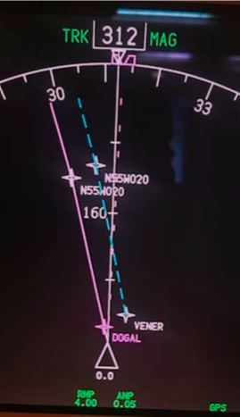
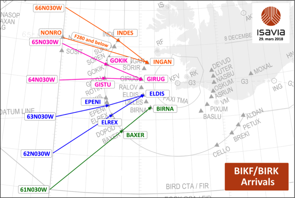
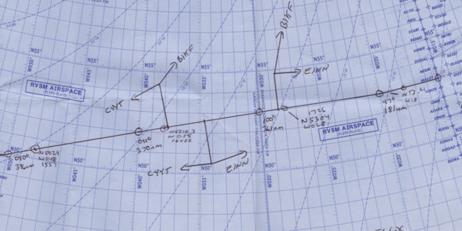
For the last few years, use of half degrees of separation has been on the rise in an attempt to enhance airspace efficiency. But on flight displays units that only show 7 digits, these half degree coordinates are misleadingly displayed as full coordinates. For instance, the half coordinate N55°30’ W020° will display as N55°W020° (see image below, which shows identical waypoint labels for points separated by half a degree!). In this case, it is imperative to view the expanded version of coordinates (degrees and minutes).

Another frequent error leading to GNE’s is transposing numbers during data entry. This commonly occurs when you complete almost the entire crossing along one degree of latitude, then fly the last waypoint at a different latitude. For example, with a cleared route of 57°N 050°W, 57°N 040°W, 57°N 030°W, 56°N 020°W, one can accidentally enter 57°N 020°W. This will put you 60nm off course.

But there is good news! These errors are easy to recognize and avoid by having a specific method of waypoint verification.

2) Waypoint Verification

Whether entered via ACARS or manually, both crew members must come together to perform a thorough cross-check. The following method recommended by ICAO in Doc007 seems to work the best:

  • One pilot reads the waypoint/coordinates, bearing and track from the FMS.
  • On the master document, the other pilot will circle the waypoint to signify the insertion of the correct FULL coordinates in the navigation computers
  • The circled waypoint number is ticked, to signify the relevant track and distance information matches
  • (In flight) The circled waypoint number is crossed out, to signify that the aircraft has overflown the waypoint.

[fancy_box box_style=”default” icon_family=”none” color=”Accent-Color” border_radius=”default” image_loading=”default”]

Cognitive Traps:

Expectation Bias is when your perception is influenced by your preconceptions. It is vital that the second crew member crosschecks from the FMS/CDU to the master document – and not vice versa – thereby increasing the chance of spotting an error.


Pop-up trip hustle – It’s one thing reading about waypoint verification, but it’s another thing actually sitting down and taking the time to do it. Do not be tempted to crosscheck your own work because you’re in a time crunch – it requires at least two separate sets of eyes.[/fancy_box]

3) Initialisation of navigation systems

The navigational integrity of your entire flight is predicated on an accurate starting position. Even a small error with on the ground can translate into a gross error later down the line in flight.

The FMS GPS position and your current parking coordinates (found on the 10-9 pages) must match. Avoid using “last position” function in the FMS – if you were towed overnight, the “last position” will be your previous location, not your current one! Sounds obvious, but mistakes happen.

Inertial systems, once aligned, must also complement the GPS coordinates. Initialisation of inertial navigation systems can take between 6-15 minutes, and errs on the longer side at more northerly latitudes – so be patient! Moving the aircraft during alignment will cause an alignment error. Bottom line: avoid repositioning/towing the aircraft during alignment, even it is to a nearby spot on the same ramp area. Position errors like this cannot be corrected once in flight.

4) Your Master Clock – (iPhones not authorised!)

Since our ETAs for oceanic waypoints must be accurate within +/- 2 minutes, it is vitally important that, prior to entry into the NAT HLA, your master clock is accurately synchronised to UTC. ICAO Doc007 has a list of approved sources from which you can set your aircraft master clock (and your iPhone isn’t one of them!). You are approved to use the GPS time which can be found in the FMS.[fancy_box box_style=”default” icon_family=”none” color=”Accent-Color” border_radius=”default” image_loading=”default”]

Cognitive Trap:

Close to the E/W Greenwich line or close to the equator, you’ll just be on the fringes of the opposing segment. So, take a close look at the E/W or N/S letter coordinates, especially if you are usually accustomed to flying from one particular geographic area.[/fancy_box][heading]Clearances & Communication[/heading]With a move away from spoken communications and towards datalink procedures, requesting, copying and verifying a clearance becomes a much simpler task! But it is still important to know your own limitations in the rare instance that you need to copy a clearance via voice.

Casual radiotelephony should be avoided

Casual radiotelephony can be the source of misunderstanding coordinates or clearances, and so all waypoint coordinates must be read back in detail, adhering strictly to standard ICAO phraseology. An example of standard ICAO phraseology requires enunciation of every individual digit. 52 North, 030 West would be read back as “Fife two north, zero tree zero west” as opposed to “fifty-two north thirty west”. Have no doubt about it, Shanwick can be the most strict in this regard.


Distractions and workload

If your departure airport is close to the oceanic boundary, e.g. Shannon or Miami, the benefit is that you will copy your oceanic clearance on the ground. Unencumbered by distractions typically associated with being in flight, you can focus almost fully on the task at hand. However, most flights pick up an airborne clearance, and it is important to prioritise this for a period of low workload.

Take the example of a Bombardier Global Express crew that narrowly avoided a GNE after copying a clearance. While they were in the midst of crosschecking the clearance with the FMS and climbing to their initial altitude, the flight attendant approached them with an issue. Instead of waiting, one of the pilots attended to the problem. A new waypoint wasn’t entered, and it was later caught by ATC in a position report. Try to avoid non-vital tasks until ALL the steps regarding copying, verifying and inputting a clearance are complete.

Following these simple standard operating procedures (SOPs) step-by-step will guard against clearance errors. If the steps are interrupted for any reason, start again from the beginning.

  • Two pilots monitor and record the clearance. The Pilot Monitoring (PM) will contact clearance delivery, while Pilot Flying (PF) monitors both the primary ATC frequency and the clearance delivery frequency.
  • The PM then records the clearance on the master document. The PF also copies down the clearance separately.
  • Clearance is read back to ATC. Any disparities between both pilots’ interpretations of the clearance must be clarified with ATC.
  • A deliberate cross check of the clearance to the filed flight plan and the FMS is made.

Re-Clearance

According to ICAO Doc007, “In the event that a re-clearance is received when only one flight crew member is on the flight deck…changes should not be executed…until the second flight crew member has returned to the Flight Deck and a proper cross-checking and verification process can be undertaken.” Sorry, they just don’t trust you to do this by yourself, and neither should you!

Errors associated with re-clearances, re-routings and/or new waypoints continue to be the most frequent cause of GNE’s. Therefore, a re-clearance or amended clearance should be treated virtually as the start of a new flight and the procedures employed should all be identical to those procedures employed at the beginning of a flight.

  • Both crews note the re-clearance
  • Reply to ATC via ACARS or voice
  • Amend the Master Document
  • Load the new waypoints into the FMS from the updated Master Document
  • One pilot verifies the input of the new waypoints reading from the FMS
  • Verify the new tracks and distances, if possible
  • Prepare a new plotting chart/re-plot in Jeppesen EFB

With datalink, you might have the capability to load the new route directly from the ATC message into your FMS flight plan. This will eliminate a transcription error on your part, but you cannot always count on the FMS to load this seamlessly. Oftentimes, if a revised coast-in waypoint doesn’t connect with your originally planned domestic airspace airway, it might cause a discontinuity. Worse, some crew have experienced their entire domestic flight plan drop out, left with only the oceanic portion.

Conditional Clearances – There’s always a catch!

A conditional clearance is an ATC clearance given to an aircraft with certain conditions or restrictions, such as changing a flight level based on a time or place. Conditional clearances add to the operational efficiency of the airspace, but are commonly misinterpreted by flight crews.

Shannon has been known upon first VHF contact to provide lateral conditional clearances on coast-in. For example: “N135AC, after DINIM, direct ELSOX”. Often, crew have been known to read back the correct transmission, but then execute the wrong procedure by proceeding directly to ELSOX.

Why is this happening? In studies of linguistics, verbs (such as ‘direct’) have been noted as having a perceptual priming effect, that more easily grabs our attention at the expense of weaker prepositions (such as ‘from’ or ‘after’). Listen carefully for prepositions. Similarly, in aviation vernacular, the word ‘direct’ means to proceed now to the specified waypoint. As pilots, we can distinguish this meaning with very little effort, and most of the time can expect to proceed present position direct. Thus, we are primed to go direct.

While this isn’t a complex sentence, research indicates that transmissions involving serial recalls (such as “proceed here then here…”) are susceptible to distortion, with the last word or item more commonly interfering with recall of the previous item.

A really simple way to prevent this is to write down clearances as they are being read to you, then read-back the transmission. You can also call attention to a conditional clearance by prefixing their read-back with the word “Verify” or “Confirm” over the radio. Via datalink, sufficient care always must be taken when factoring in all the contents of a clearance before acknowledging the message. The initial phrase “MAINTAIN FLIGHT LEVEL 300” is included to stress that the clearance is conditional. If the message is about to time out, and you need more time to process its contents, reply using “Standby”. Respond at your own pace![fancy_box box_style=”default” icon_family=”none” color=”Accent-Color” border_radius=”default” image_loading=”default”]

Cognitive Trap:

On the longer route segments between New York and Santa Maria, “when able higher” (WAH) reports might be solicited. ATC acknowledgement of a WAH report must not be misconstrued as a conditional clearance to climb. Any climb clearances will be issued separately from a WAH acknowledgement.[/fancy_box][heading]Miscellaneous[/heading]

10-minute Check – put the (Bad) Elf on the shelf for this

One of the best ways to capture a potential GNE and refresh your situational awareness is with the sublimely simple 10-minute check. Ten minutes after waypoint passage, you’ll use your current coordinates to plot your position on your plotting chart. If the coordinates don’t land on the plotted track line, an investigation into the source of the error must begin immediately. It doesn’t hurt to even make additional plots between waypoints too, but ICAO only requires the one 10-minute check.

Today, more pilots are carrying independent GPS units in their flight bags, providing crew with own-ship on their oceanic route map. Tempting though it may be to use this for present position information, it is currently not an approved source of navigation, and should NOT be used in lieu of a 10-minute check.[fancy_box box_style=”default” icon_family=”none” color=”Accent-Color” border_radius=”default” image_loading=”default”]

Cognitive Trap

It is easy to forget about the 10-minute check. Setting a timer once your waypoint passage tasks have been completed will help remind you to do so.[/fancy_box]

Autopilot mode – “Wait, are we supposed to be in heading?”

Incorrect autopilot mode selection has been known to be a factor in GNE’s. On an oceanic crossing, you can bank on being in NAV or LNAV most of the way across the Atlantic. But perhaps you used heading mode to deviate for weather or to intercept a SLOP. It is not uncommon among pilots to spare your passengers two steep banking turns (thanks LNAV!) by manually flying a SLOP intercept in heading mode. But if you forget to re-engage LNAV, you will continue drifting on your merry way, further and further off course.

Distraction, fatigue or complacency are common reasons for losing mode awareness, so the following simple tricks will help mitigate autopilot induced GNE’s.

  • It helps to verbally announce when you are transitioning temporarily into heading mode, to bring both pilots in the loop.
  • Employing sterile cockpit until you’re back in LNAV will help mitigate distractions.
  • In an abundance of caution, you can keep a finger on the heading button or heading dial until you are back in LNAV will serve as a reminder.

[fancy_box box_style=”default” icon_family=”none” color=”Accent-Color” border_radius=”default” image_loading=”default”]

Cognitive Trap:

The flight mode annunciators (FMA’s)  are the most reliable indicators of automation selection – more so than the flight guidance panel! Yet, a study found that pilots pay superficial attention to the FMA’s during critical mode changes. Don’t waste a valuable resource, and do consciously bring the FMA’s into your scan.[/fancy_box]Deliberate cross-checking and monitoring are a critical last line of defense for which we, as pilots, don’t get explicit training, but are nevertheless expected to perform effortlessly. But over the North Atlantic, there is little room for error. So, let’s recap what can be done!

  1. Allow sufficient time on the ground to set up
  2. Closely scrutinise data entry – whether the source is human or ACARS!
  3. Work together on waypoint verification
  4. Don’t work single pilot – always keep all crew in the loop
  5. Deal with clearances and re-clearances methodically

Understanding our vulnerabilities is key to the process of mitigating errors. Armed with an understanding of our own limitations, and an appreciation for the practices and habits mentioned above, a ‘would-be’ GNE can be averted.

Links

ICAO Doc 007 

Global Operational Datalink Document (GOLD)
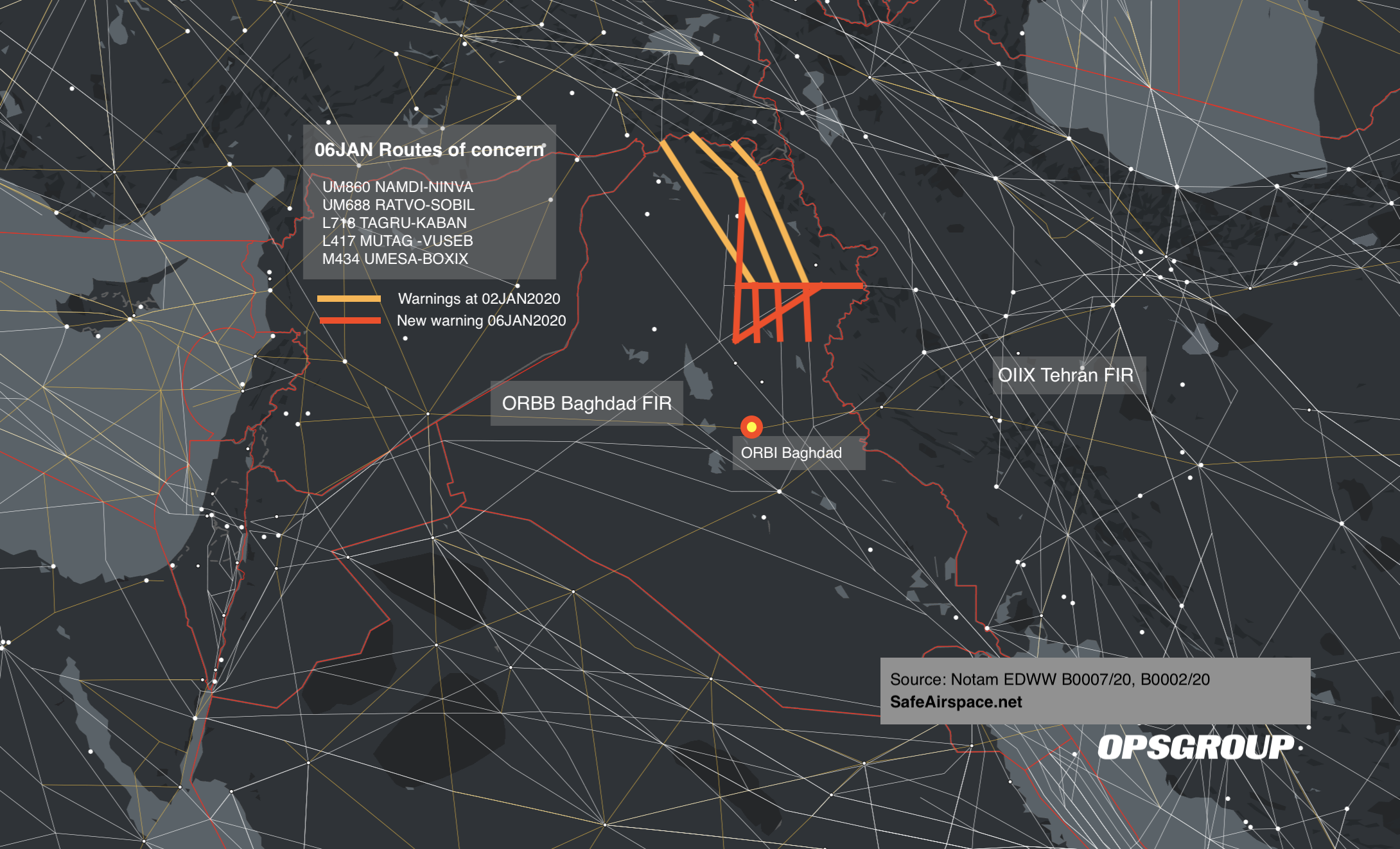
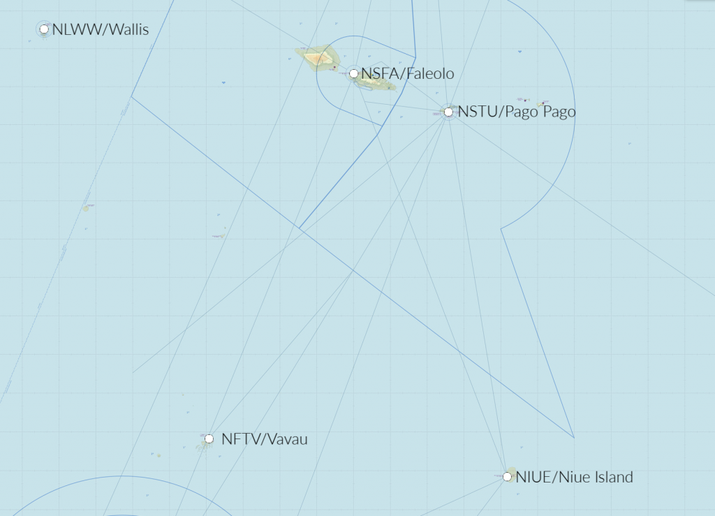
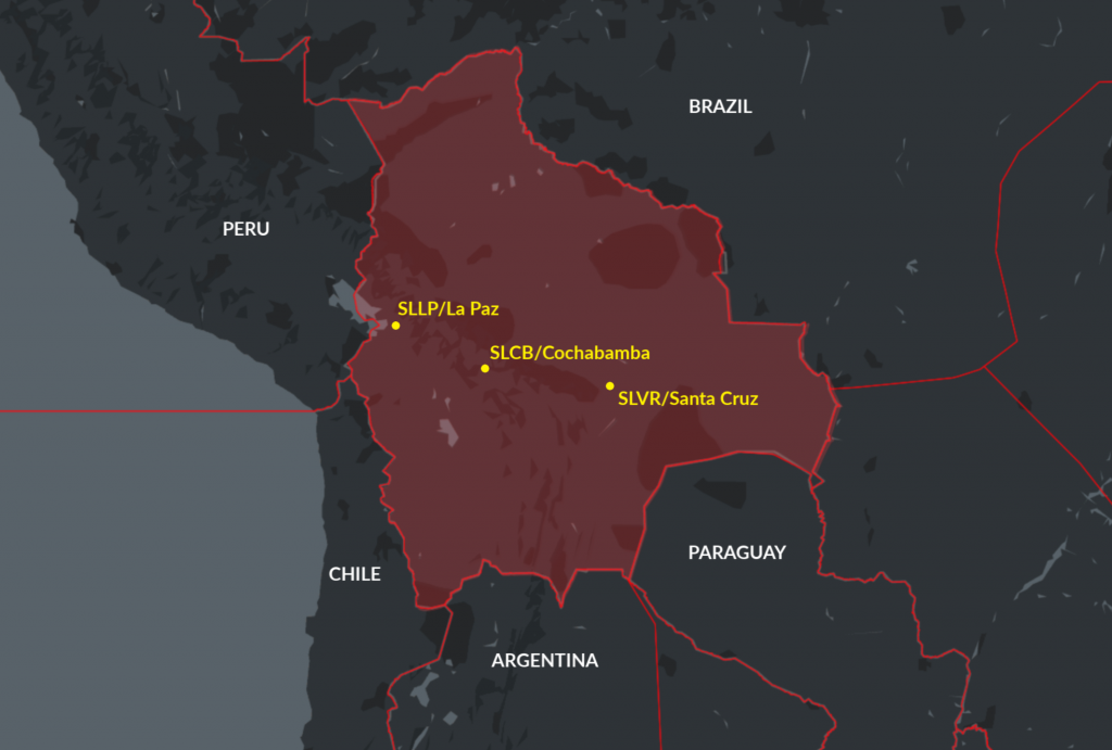

Three-day French ATC strike this week

French ATC strike alert! And this one’s going to be a MONSTER!! Notams have now been published confirming this week’s strike will last for three whole days, from 1800z on Wednesday Dec 4 until 0500z on Sunday Dec 8. 

It’s part of a nationwide strike which will also impact ground handling services at airports nationwide. Initially called by public transport unions opposed to the government’s pension reforms, various other unions have since pledged to join the strike, including public sector workers, teachers, postal workers, hospital staff, firefighters and lorry drivers. Many unions have warned that strikes might run until Christmas, but for now, air traffic controllers have only planned strike action for three days this week.

In the Eurocontrol teleconference on Monday Dec 3, managers said they expect en-route regulations will be applied across all sectors – which means big delays pretty much everywhere. If you can avoid France during this period, do so.

The situation at the airports is slightly more complex. The worst staff shortages are expected to happen at the ACC level, rather than at the local airport level. However, there are some airports which are expected to have some issues:

LFPG/Paris Charles De Gaulle: On the morning of Thursday 5th Dec, there will be an airport firefighter strike between 07-12 local time (06-11z). As a result, only one runway will be available for this period, so significant delays are expected all morning, particularly if weather conditions aren’t so great.

LFBO/Toulouse & LFBD/Bordeaux: High delays expected all three days

LFBP/Pau, LFBT/Tarbes, LFBZ/Biarritz, LFMD/Cannes, LFOP/Rouen, LFQQ/Lille: Smaller airports mean possible closures, particularly at night. For these and other smaller airports, ATS services may not be provided at all at certain times – and you’ll probably need to check the airport’s own Notams for any signs of that.

Additionally, the government has stepped in and decided to request the airlines to reduce their schedules by 20% between 05-23z on December 5th at these airports: LFOB/Beauvais, LFPG/Paris Charles De Gaulle, LFLL/Lyon, LFML/Marseille, LFBO/Toulouse, LFBD/Bordeaux. The Notam confirming that can be found here.

As usual with these French strikes, Algeria and Tunisia have both said their airspace can be used by flights trying to route around French airspace, without having to obtain overflight permits. But operators need to make sure they add their AFTN codes on flight plans! That means don’t just file your FPL to the normal Eurocontrol addresses, but include those for Algeria (DAAAZQZX and DTTCZQZX) and Tunisia (DTTCZQZX and DTTCZRZX) – and make sure these are included for any subsequent DLA messages as well.

For real-time updates of any airspace issues once the strike has started, keep an eye on this handy French ATC webpage: http://dsnado.canalblog.com/

And check out our article for everything else you need to know about how to survive French ATC strikes!


Deteriorating post-election chaos in Bolivia

A single Notam for the country’s largest international airport indicates there’s no fuel available for a number of days. That’s always a surefire sign that something pretty serious is going on. 

The contested presidential elections last month in Bolivia has quickly led to civil unrest across the country in the past few weeks. Demonstrations, strikes, and roadblocks have resulted in armed conflict between opposing protesters as well as armed forces in which 32 people have died so far in what some are calling an uprising and others a coup. We’re going to take a look at the cause of the unrest and how international operators may be affected, especially when the trucks carrying your jet-fuel to the airport are attacked.

The Escalation

Evo Morales, the long-term Bolivian President won a contested election in October, but evidence quickly surfaced that the results were manipulated. Protests from Morales opposers erupted when Morales refused to stand down until eventually resigning when the military “requested” he do so in the interest of stability, but not before the current unrest unfolded. He is now seeking asylum in Mexico. Three other officials who were in line to be the constitutionally defaulted interim presidents all resigned and/or fled the country. The role eventually fell upon the deputy leader of the Senate and opposing party member, Jeanine Anez, who promised to hold new elections soon. Some countries are recognizing Anez as the President, while others are refusing to do so.

Morales supporters began countrywide protests as he would not be included in the new elections, a move they claim to be a part of a larger military coup. Protests between the two groups and with the armed forces have led to volatility in the past month. Bolivia’s constitution calls for the new elections to be held within 90 days.

Security

The US State Department has issued a Level 4: Do Not Travel Advisory for the entire country. State department non-emergency employees and their families have been ordered to evacuate. A Notam for SLLP/La Paz airport has been issued stating there is no fuel available. Protesters attacked a military escorted fuel convoy headed to the airport from a large nearby fuel plant, and further protests have been planned to occur near the airport. The Notam for La Paz has been pushed back three times so far and there’s no estimate of when fuel will again be available.

“We have not had anyone going into Bolivia for well over a month,” said Brian Leek, owner and CEO of FAM International Security, a global corporate security solutions firm. “If you don’t HAVE to go, don’t. Simple answer. Things have been brewing there for months and it finally burst last month.”

The demonstrations and barricades have closed roads in La Paz as well countrywide highways and access to airports. Security cannot be guaranteed. The intervention by the armed forces has escalated quickly, with tear gas and live ammunition being fired to disperse protests resulting in deaths across many of the larger cities like La Paz and Santa Cruz.

Is It Safe To Travel Throughout Bolivia?

Due to the instability, the simple answer is: Not right now. Leek is advising all operators to defer travel, at least until the beginning of December or whenever the new elections are announced. With the news that elections will be held soon, there is optimism that the violent protests will decrease as Morales opposition leaders are calling for peace. However, many Morales supporters state they will continue protests in demand that the former president be given an opportunity to return. One international medical and travel services company received reports of clients’ cars being attacked by protesters and one car being hit by an armed forces vehicle responding to a demonstration.

If you do operate into Bolivia, local ground handler, Pike Aviation, is recommending SLVR/Santa Cruz where fuel and full services are available and the protests in the city are minimal. SLCB/Cochabamba is also operating normally, but conflicts continue in the city. They also do not recommend operating into SLLP/La Paz. Leek couldn’t agree more. “If you have to go, Santa Cruz is an acceptable substitute. Just know that security around the airport is weak. So have plans in place to protect the aircraft.”


Italy nationwide ATC strike on Nov 25

Update Nov 22: The Italian ATC strike on Monday 25th Nov isn’t going to be as bad as expected. The 24 hour strike has been downgraded to a 4 hour strike, from 12-16Z, 1-5pm local. Overflights and intercontinental arrivals exempt; other traffic may see a delay but it will vary from place to place. Primarily, it is the en-route center controllers that are striking.


ATC staff from all four ACC’s across the country (LIRR/Roma, LIBB/Brindisi, LIMM/Milano and LIPP/Padova) will be on strike, plus local ATC at the following airports: LIRA/Rome, LIBR/Brindisi, LIBD/Bari, LIBP/Pescara.

Watch out if you’re headed to either LIPY/Ancona or LIRZ/Perugia though – ATC at these airports will still be going on strike for the full 24hrs as originally planned, so big delays expected here.

For updates, keep an eye on the Eurocontrol NOP page on the day of the strike.


Regulatory deadlines on the horizon

Regulatory compliance – nothing quite warms the heart like reading those two words, side by side. This year has seen quite a few changes in this department already (thank you, NAT HLA!), but here is a list of some other regulatory deadlines on the horizon…

Dec 31, 2019 – Operations in North Atlantic

  • U.S. operators must have the revised LOA BO39: “Operations in North Atlantic High Level Airspace (NAT HLA)”. Operators holding the old MNPS LOA BO39 will not be permitted to fly in the NAT HLA beyond this date. Requirements include: RNP10, crew training and new contingency procedures incorporated in company operating handbooks. Read our article here.

Jan 1, 2020 – US ADS-B Out Mandate

  • ADS-B Out will be required where Mode C is required AND:
  • Class A, B and C airspace, Class E at or above 10,000’ MSL (but not below 2,500’ AGL).
  • Within 30nm of Class B (Mode C veil).
  • Above the ceiling and within lateral boundaries of Class B and C up to 10,000’.
  • Class E over Gulf of Mexico, at and above 3000’ MSL within 12 nm of US coast.

Jan 30, 2020 – Expansion of Datalink Mandate in the North Atlantic

  • Phase 2C of North Atlantic Datalink Mandate. FANS 1/A CPDLC and ADS-C will be required between FL290-FL410 throughout the entire NAT region (previously FL350-390). Read our article here.

Feb 5, 2020 – European Datalink Mandate

  • Initially legacy aircraft flying above FL290 in European airspace were to be equipped with CPDLC capability by Feb 2015. But due to equipage requirements and technical issues the mandate was delayed to Feb 2020, AND, even better, most GA/BA aircraft will be exempt from this. Read our article here.

June 7, 2020 – European ADS-B Out Mandate

  • Aircraft flying IFR in Europe with max certified takeoff weight of more than 5700kg (12,566lbs) OR max cruising TAS of more than 250kts must be equipped with ADS-B. GPS sensor with at least WAAS accuracy coupled to a 1090 Extended Squitter transponder required.


DELAYED:

Canada: ADS-B Out Mandate

  • This was planned to be implemented in Class A airspace from Feb 2021, and Class B airspace from Jan 2022. But Nav Canada has now postponed this mandate. They still plan on using ADS-B for surveillance, and this will be used on a priority basis for suitably equipped aircraft starting in 2021, but they say – “non ADS-B Out equipped aircraft will be accommodated within the airspace until a performance requirements mandate can be implemented.”

ALSO ON THE HORIZON:

August 14, 2020 – EU: SAFA Ramp Checks & Pilot Mental Health

  • EASA regulations requiring alcohol testing during ramp checks will take effect across all SAFA participating countries (although some countries have already started doing this: Austria, Belgium, Czech Republic, France, Germany, Greece, Iceland, Ireland, Italy, Netherlands, Portugal, Spain, Switzerland, UK, and Singapore). Tests may also be carried out by local police at any time.
  • All pilots working for European airlines will have access to mental health support programs.
  • European airlines will perform a psychological assessment of their pilots before the start of employment.

Any other biggies that we missed? Let us know!


Venezuela issues another surprise ban on GA/BA Flights

On Nov 15, authorities in Venezuela issued a Notam immediately suspending all GA/BA flights from operating to airports in the country. The ban was due to remain in place until 2359z on Nov 20, but got cancelled on Nov 18.

Here was the Notam, issued by the SVZM/Maiquetia FIR:

A0842/19 – GENERAL AND PRIVATE AVIATION OPS INCLUDING REMOTELY PILOTED AIRCRAFT SYSTEM (RPAS) ARE SUSPENDED. OVERFLIGHTS CROSSING SVZM / FIR ARE ALLOWED. 15 NOV 10:00 2019 UNTIL 20 NOV 23:59 2019. CREATED: 15 NOV 04:01 2019

The last time the Venezuelan government issued a ban like this was back in Feb 2019, which seemed to be related to wider attempts by the government to limit the travel of opposition politicians. This latest ban probably had similar motivations – with Venezuela’s President Maduro calling for government supporters to march and rally across the country on Nov 16 to counter protests called for by oppposition leader Juan Guaidó in Caracas on the same date.

U.S. operators have been prohibited from operating to Venezuelan airports — and from overflying the country below FL260 — ever since 1st May 2019 when the US FAA issued a “Do Not Fly” instruction. Two weeks after that, the U.S. ordered the suspension of all commercial passenger and cargo flights between the U.S. and Venezuela, and this applies to both U.S. and foreign registered carriers.

Our advice remains the same: you don’t want to go to Venezuela at the moment. The official advice of both the US and Canada couldn’t be clearer, they both say the same thing: do not travel to Venezuela due to risks posed by the ongoing unstable political and economic situations and the significant levels of violent crime.

For overflights, here’s what we suggest…

To the WEST
– via Colombia (SKED/Bogota FIR) – permit required for all overflights.
Note: watch out if planning a flight through the TNCF/Curacao FIR – although a permit to overfly is not required here, you will need to prepay for navigation fees in advance. More on that here.

To the EAST
– via Guyana (SYGC/Georgetown FIR) – permit not required
– via Suriname (SMPM/Paramaribio FIR) – permit required
– via French Guyana (SOOO/Rochambeau FIR) – permit required unless operating a GA aircraft under 12.5k lbs.

If you need a tech stop and previously used/considered SVMI, then look at alternatives like TNCC, TTPP, SBEG, SMJP. Use OpsGroup’s GoCrow planning map to figure your best alternate options:


New Procedures at Nice: Beware the Big CDM Computer

Nice Airport will launch Airport Collaborative Decision Making (A-CDM) on Nov 25. The main impact to operators will basically be that strict timings will have to be adhered-to for the entire start-up process: flight clearance, engines start-up approval and parking off-block will all have to be done within strict timeframes, otherwise your flight will drop out of the CDM system and you’ll likely get hit with a significant delay.

Top tips from local handler Swissport are as follows (we’ve paraphrased slightly):

Flight dispatch:

  • It is now compulsory to file the flight plan so that it exactly matches the Airport Slot booked by your ground handler. If the flight plan and the Airport Slot timings are not exactly the same, the Big CDM Computer at the airport will get terribly confused, your flight plan will get rejected, and you won’t be flying anywhere.
  • As a consequence, any time you want to change your schedule you must let your handler know first! They get a new Airport Slot for you first, then enter your flight into the CDM system, and then you can change your flight plan.

Flight deck crew:

  • Strict timings will have to be respected for the start-up process : flight clearance, engines start-up approval and parking off-block will have to be performed in due time, otherwise the flight will be SEQUENCE OUT and the CDM process will have to be reset, resulting in significant delays.
  • The TSAT (Target Start-up Approval Time) is the key timing since all the departure process is based on it. Your ground handler can provide you with your TSAT, and it can also be monitored directly by the crew on the CDM website (see the attachments below on how to do that).
  • The transponder is part of the process for the validation of some CDM milestones. The transponder should be switched on before taxiing and switched off once on-block. Switching the transponder on/off during taxiing generates wrong timings in the whole process management, and the Big CDM Computer doesn’t like that.

Bottom line, just make sure you keep talking with your ground handler throughout the whole departure process, so they can manage all these times for you in the system.

Swissport has provided a handy guide for operators on what to expect (click the image below to open the full version!):

Other things worth knowing at LFMN/Nice:

  • With the change to RNP approaches only (i.e. what would be known in the U.S. as RNAV GPS approaches), the airport is filing violation reports even if you request and get cleared for any other type of approach. The tip is to double check your FMS database before you fly to confirm all approaches are loaded, especially the RWY 04 RNAV-A and RWY 22 RNAV-D. See Airport Spy reports on LFMN for full reports.
  • From March 2019, any schedule change (ETA, ETD, flight number, provenance or destination airport) will generate a new PPR number – now called “Slot ID” – that will have to be updated in the FPL, still in field 18. Bear in mind that this process will take at least 10-15 minutes to have the new schedule validated by the airport and get the new Slot ID.
  • France has started a thing called CASH – Collaborative Aerodrome Safety Highlights. It’s basically a selection of briefing packages for certain airports, drawn from information supplied by airlines, operators, and ATC. So far, they’ve published ones for LFBK/Bastia, LFOB/Beauvais, LFKC/Calvi, LFPB/Paris Le Bourget, LFPG/Paris Charles De Gaulle, LFMN/Nice, and LFBO/Toulouse. More info


U.S. cracks down on scheduled flights to Cuba

The U.S. has announced it will suspend scheduled flights to all airports in Cuba except for MUHA/Havana, in another attempt to limit cash flows going to the Cuban government. The affected airlines, including American, Delta and JetBlue, now have 45 days to wrap up their operations to those other destinations in Cuba, before the ban goes into effect on Dec 10.

This does not apply to Part 135 non-scheduled charter flights – these are still allowed to operate from the U.S. to any international airport in Cuba. However, it’s still a tricky business to operate these flights and stay within the rules. Policies introduced by the Office of Foreign Asset Control (OFAC) in 2017 mean that there are only a handful of categories of permitted travel between the US and Cuba.

As for Part 91 private flights from the U.S. to Cuba, these have been completely banned since June 2019. This was a policy introduced by the US Bureau of Industry and Security (BIS), which meant that U.S. operators could no longer operate an N-reg aircraft privately to Cuba for any reason – it doesn’t matter if your passengers meet OFAC’s “permitted categories of travel” or not, it’s a no-go.

For non-U.S. operators traveling to Cuba from anywhere other than U.S. territory, it should be a doddle. Get a landing permit, arrange your ground handling, file your flight plan, and off you go. Check out our article for more info.

If you’re headed to Cuba — even to MUHA/Havana — you should double-check with your insurance provider about your coverage. We received the following report, which suggests that with the new U.S. sanctions, many U.S. operators may no longer be covered:

“Being the insurance director of an Airline, I’m having the dilemma whether the insurance would cover any damages/losses/injuries may have occurred during Cuba flights. Because, when I raised the question, insurers simply replied with an aviation clause called AVN111/AVN111(R) which says insurers would verify each individual case with relevant sanction authority (in this case, OFAC) and do their best to grant permission to reimburse the losses. It can easily take years to get resolved which essentially means there is no actual protection against losses”…

In principle, U.S. operators with an insurance policy from a non-U.S. based insurer can get insurance cover for Cuban ops. However, in practice it may not be possible to even purchase this, as lots of these policies are underwritten by U.S. based insurers – especially for higher policy limits.


Escape From New York: How To Get In & Out of Teterboro (2019)

There’s nothing that will drain a smartphone battery quicker than a ground delay in Teterboro. Preflight complete, flight plan loaded, passengers onboard (they were actually on time for a change), engines started and – wait for it – you are instructed to contact “ground metering.” The word itself can make the stomach drop.

Yes, a line of thunderstorms is moving in, but it’s not quite solid. Most of my route does not look affected, but far better minds than mine have determined that diverting traffic require them to close my entry gate, as well as most of the surrounding ones. I receive an Expect Departure Clearance Time (EDCT) of over three and a half hours away!

Normally I make it as far as taxiing just short of TEB’s RWY 24 before the controllers present me with such a lovely ground delay and instruct me to park in the “penalty box.” This time I hadn’t even left the chocks (I wasn’t even actually supposed to start the engines before contacting “metering”, but of course I didn’t admit that mistake to the controller).

Ground delays due to weather or traffic saturation are not uncommon in Teterboro. We have to hand it to the Teterboro ATC staff for efficiently controlling one of the busiest GA airports in the world (about 174,000 arrivals a year). They not only deal with all the complications that come with being located under some of the most congested airspace in the world, they patiently work everyday with a bunch of A-list pilot personalities that think their schedules are more important than any delays. Well done, you ninjas of New Jersey!

Weather, traffic and pilots aren’t the only issues they’ve been dealing with lately. Improvement projects have been steadily grinding along for the past year and a half. And guess what? There’s even more to come!

So, after I inform my passengers of this delay, allow me to hop back up in the cockpit and let’s discuss some Teterboro info with the help from our good friend Dave Belastock, President of the Teterboro User Group. Perhaps you heard him speak on the latest OpsChat, but, if not, we’re going to dive in a little deeper.Oh, by the way, don’t be offended while I analyze my fantasy football scores on my phone; I’m a multi-tasker, and we’ve got three and half hours – well three now – to go and I’ve got 85% battery life on my phone left.


EDCT: T minus 3:00, battery 85%

The Entry

Getting into Teterboro can often be a frustrating game. When calling for a clearance at your departure airport, wagers can be made that an EDCT will be issued. Gone are the days in which operators would file a nearby airport (KMMU/Morristown, KHPN/White Plains, etc.) and change the destination to TEB enroute to avoid such ground delays. I’ve never tried it, but I did witness a former chief pilot broach the subject with clearance delivery at a Midwestern airport about attempting this. “If you to try that stunt, I’ll route you through Florida,” was the controller’s response.

But getting the heads-up on delays may depend upon early filing. The FAA’s Traffic Management Unit coordinates the flow programs into airports experiencing delays. According to one TMU official, “Get your flight plan filed prior to program implementation (at least a day in advance) and try not to change that proposal time. The command center ‘optimizer’ computer will issue releases/slots based on those times. And your flight plan won’t drop out of the system until 2 hours after your EDCT.”

I’ve had service providers tell me that the earlier you file, the higher up you are on the departure list. I never knew if this was true or not, but it may look like it certainly has a partial effect.


EDCT: T minus 2 hrs 30 mins, battery 67%.

Upon arrival into Teterboro, you will watch your TCAS light up like a Galactica arcade game, especially on a clear day. Glider activity near the MUGZY waypoint on the LVZ STAR to the northwest and GA traffic from multiple small airports flock below you. And the question usually comes up once you are beneath Newark’s Class B airspace: “What speed should we be going?”

The answer is of course 200 knots. But more than once I have been angrily asked by a controller what my speed was and, after answering 200 knots, speed reductions were quickly mandated to traffic following behind me. Thus, there was a perception that NY Tracon needed you to keep your speed up into TEB. But no controller may authorize an aircraft to exceed 200kts under Class B. If it makes you feel better to report your speed reduction, be my guest. But the answer is 200kts.

Those familiar with TEB approaches understand that you must certainly be on your game and brief your approach. The ILS RWY 6, including the circle to land RWY 1, has a mandatory altitude of 1500 feet at DANDY that pilots are still not making before intercepting the glide slope. The circle procedure can be tricky, especially with a tall antennae to the south of the airport. And if winds are gusty from the northwest expect turbulence from the distant hills. In 2017, a Learjet became unstable during this approach, stalled and crashed as the crew were unprepared for the approach. Early briefing and proficient monitoring will ensure a safe and simple approach.


EDCT: T minus 2 hrs, battery 50%.

Belastock mentions that a new RNAV GPS RWY 19 with LPV mins is expected to be published in December. Some aircraft flying a coupled ILS RWY 19 with the localizer captured at 2000 feet have experienced an uncommanded climb due to a false glide slide capture. This glide slope perturbation is triggered by aircraft moving on taxiway Q across RWY 19 and passing in front of the glide slope antennae, which briefly deflects the signal downward enough to satisfy capture parameters. Once the taxiing aircraft has cleared the glide slope critical area, the beam returns to its proper angle. If you have Approach mode armed, the autopilot may grab the temporarily deflected glide slope and then pitch up when the signal returns to normal. Close monitoring and quick action are required to prevent an altitude deviation. The GPS approach would circumnavigate this potential issue.

And speaking of that turn between UNVIL and TUGGZ to intercept the final approach course, you could very well see VFR aircraft just below you. You are outside Class D airspace at that point so separation requirements aren’t necessary. While other NY area airports have communication requirements for VFR traffic transitioning near congested airspace, TEB has none. TUG is currently working with the FAA to create a Class D transition area to the north to require communication. Fingers crossed.


EDCT: T minus 1hr 30 mins, battery 42%.

The Escape

RWY 6-24 is going to see substantial improvement in 2020. Currently, the plan is to close the runway several evenings through the summer, starting the day after Memorial Day through Labor Day. “Port Authority of NY and NJ staff have worked diligently to create a schedule that would least affect operators,” explained Belastock. “We are anticipating RWY 6-24 to close from 10pm Saturday nights until noon on Sundays. And then there will be two 24-hour closures beginning at 10pm Friday through Saturday night at dates to be determined.”

This will inevitably switch up the normal departure procedures. Whereas the RUUDY RNAV departure (we’ll discuss good ol’ RUUDY in a second) is the traditional departure, the alternative will be the DALTON 2 departure.

“Do you ever wonder why you have to hold short of RWY 24 for an extended period of time waiting for an IFR release?” asks Belastock. “That’s because NY Tracon requires a 10nm separation between you and the overflying Newark traffic.” The Dalton departure, however, is a VFR-IFR departure.

VFR? Really?

Yep, just as the instrument departure plate reads, aircraft depart VFR – 3 sm visibility and 3000’ ceilings are required – and when handed over to the departure controller, the IFR flight plan is activated. Theoretically there is no gap required between the VFR Teterboro departures and IFR Newark arrivals. But consideration was taken between all stakeholders, and a 5nm gap between TEB and EWR traffic was agreed upon. “TEB clearance can’t solicit the departure. You must request it and have a published departure plate available in the cockpit,” said Belastock.

Though this could mean a reduction in release time, if there is a delay in progress controllers can only offer an “indefinite delay” for traffic or weather issues, whereas they can give you a set time if using the other IFR departures. “Actually, NY Tracon is encouraging it. They want pilots and controllers comfortable with it,” said Belastock.

As for the RUUDY RNAV departure, good news! Pilot deviations are decreasing. Belastock and TUG worked closely with training facilities as well as OPSGROUP to get the word out. I even noticed the RUDDY departure was included in my latest recurrent simulator training. With the altitude restriction and noise abatement restrictions pilots need to be extremely situationally aware. “We don’t want to tell pilots how to fly their aircraft,” said Belastock. “But we need them to be fully aware of how the departure operates.”


EDCT: T minus 1:15, battery 37%.

The Window of Opportunity

My eyes are burning a bit from so much screen time on my phone. I query Gate Hold again – just like the other 73 pilots that are trying to chime in. Yep, that’s me you’re rolling your eyes at.  My EDCT time is actually extended further even though the weather is past my entry gate. “Is there anything we can do to get out of here,” I reply with a frustration.

“Can you fly a final altitude of 14,000 feet?”

Confusion mixes with a sense of impending opportunity. “Standby,” I answer. I always take extra fuel out of TEB, but I’m sure there cannot be enough to fly that low. I run the numbers…and, I’ll be damned, we can make the destination with a safe fuel reserve.

“Actually, yes we can,” I reply excitedly. “Start your engines and contact ground control,” comes the reply. As I taxi past all the other waiting aircraft, I couldn’t help but feel a sense of guilt…and some pleasure as well.

We departed on the RUUDY departure, flew west while climbing to 14,000 feet talking to NY Center and several approach controllers. When we were handed off to Cleveland Center, we requested a more appropriate cruising altitude and given it without question.

I later called TEB tower to see how this “gift” actually occurred. “It doesn’t happen often. But since your entry gate and route were getting so saturated with diverting traffic, you couldn’t fly it at your filed altitude. But this wasn’t the case for the lower altitudes,” explained the controller. “I can’t offer it unless you specifically ask. But even then it probably won’t be granted.”

I’ve been flying in and out of TEB for 15 years, and I’m still often learning new details about its operation. Perhaps I’ll keep this tool in my back pocket for the next great escape.


Mexico’s revamped CAA to make permit applications even tougher

If you thought that applying for Mexican landing permits couldn’t possibly get any more complicated, then think again!

On 16th Oct 2019, the Civil Aviation Authority in Mexico (DGAC) became the Civil Aviation Federal Agency (AFAC), and it sounds like they mean business. Local handlers are saying that policies and procedures that were typically overlooked or handled with lax criteria in the past are now expected to be more strictly enforced.

The following changes apply to Part 135 commercial operators looking to obtain Mexico landing permits. (For Part 91 private operators, no changes to the current rules and requirements are expected at present).

Insurance Policies

It’s long been the case that you need two insurance policies for ops to Mexico: your standard worldwide one, and a specific Mexican one issued by a Mexican company.

Authorities are now saying that for both of these policies, the original copies must be submitted in full; with coverage details, proof of payment, and aircraft details clearly shown. Digital copies are not good enough, and there have been some cases reported where applications have been rejected due to seemingly trivial things such as the signatures being too blurry, or even the “courtesy translation” stamp being on top of a signature.

Power of Attorney

To get a landing permit for Mexico, you need to nominate a local handling agent, sign a Power of Attorney saying that they are your legal rep there, and then the CAA will release the permit to them.

Previously, authorities were happy enough with a scanned copy of this Power of Attorney, but they are now saying this must be submitted as a notarized original with an Apostille. If you’re applying for Single Landing Authorization (see below) for short notice operations, you will have to send a digital copy of this, and commit to follow-up by sending the original copy too once available.

Single Landing Authorizations (one time shots):

The CAA traditionally allowed operators up to five Single Landing Authorizations before requiring an Indefinite Blanket Permit if operators continued flying into Mexico. The AFAC is now cracking down on this. So “one and done” will be the new rule with Single Landing Authorizations. After that, the Indefinite Blanket Permit must be applied for (although you should still be able to obtain SLA’s on a case by case basis, once your application for the Blanket Permit is underway).


Whether these implementations will continue to be enforced in the long-term remains to be seen. But for now, it looks like operators should prepare to apply for the Indefinite Blanket Permit if they are planning on doing more than just one flight to Mexico. Here is the original post on this topic by local Mexican agent Manny Aviation – we thank them for their help with alerting us to this!


Libya Airspace Update Oct 2019

On 23rd Oct 2019, the US issued an emergency order prohibiting U.S. operators from flying in Libyan airspace. The guidance here is very clear: do not operate anywhere in the HLLL/Tripoli FIR, at any flight level.

This follows months of civil war in Libya, with militia from the east mounting a campaign to seize control of Tripoli, including HLLM airport, and threatening to shoot down aircraft operating in western Libya.

In recent months there have been a number of airstrikes targeting HLLM/Mitiga airport, the latest coming on Aug 15, which reportedly killed two people and forced the airport to close. There are videos on social media showing planes landing at the airport as shells are falling in the background.

Prior to yesterday’s announcement, the U.S. guidance on Libya was that operators were allowed to overfly Libya at FL300 or above, except an area in the north-western part of the country over Tripoli, where all flights were prohibited. Here’s what that looked like:

But this guidance is now defunct. The FAA website now shows the updated guidance for Libya – including the Background Notice.

Germany and Malta still have warnings in place which mirror the old advice of the U.S. – do not fly over the north-western part of Libya, but overflights of the rest of the country are permitted at the higher flight levels. The UK and France advise against all overflights. These warnings may be updated in the coming days, following the new advice from the U.S.

Libya remains politically unstable, with a fragile security situation across the country. In their SFAR issued back in March 2019, the U.S. said that the main threat to aviation at the lower flight levels stems from the widespread proliferation of man-portable air-defence systems (MANPADS) across the country:

“Both GNA and advancing LNA forces have access to advanced man portable air defense systems (MANPADS) and likely anti-aircraft artillery. These ground-based weapon systems present a risk to aircraft, but only at altitudes below FL300. LNA forces have tactical aircraft capable of intercepting aircraft at altitudes at and above FL300 within the self-declared military zone in Western Libya, which may present an inadvertent risk to civil aviation operations in Western Libya. While the LNA tactical aircraft threat is likely intended for GNA military aircraft, an inadvertent risk remains for civil aviation at all altitudes due to potential miscalculation or misidentification.”

However, there are factions on the ground in Libya which possess weapons capable of targeting aircraft above FL300. The LNA is one of many armed groups in Libya which continues to use various rocket systems looted from Gaddafi’s stockpiles at the end of the war in 2011. In May 2018, the LNA proudly displayed a refurbished Russian-made surface-to-air missile system at HLLB/Benina Airbase in Benghazi. This system has the capability to engage aircraft at altitudes up to FL450.

The opposing GNA forces have surface-to-air missile systems of their own. Some reports indicate that the GNA are in possession of the Russian-made SA-3 system, which has the capability to engage aircraft at altitudes over FL800.

With the current conflict between these and other rival factions on the ground in Libya now escalating, it’s not clear what level of control the main players hold over their missile systems.

Bottom line, there’s still a potential risk to aircraft at all altitudes and across all parts of Libya.

Even if you are allowed to overfly the country, there are only two approved routes available, in the far north-eastern corner of the country, as per HLLL Libyan Notam A0063/17:

Northbound: LOSUL UP128 LAB UM979 RAMLI UZ270 OLMAX (even levels)
Southbound: RASNO UY751 LOSUL (odd levels)

Even on these routes, reliable ATC services cannot be guaranteed. The past few years have seen regular ATS and radar outages across the HLLL FIR airspace, and severe limitations in VHF capability, with operators having to communicate with Malta ATC for guidance.

Given the current security concerns, we continue to list the entire country as “Level 1 – Avoid” at SafeAirspace.net


Italy ATC strike on Oct 25

Notams have now been published advising of the planned nationwide ATC strike on Friday Oct 25.

The strike will happen between 13-17 local time (11-15z), although it looks like the LIBB/Brindisi sector in the south-east of the country will run from 12-16 local time.

When these 4-hour strikes go ahead, overflights and “incoming intercontinental flights” (i.e. those from outside Europe) are normally not significantly affected, but there are often big delays for flights to/from Italian airports.

LIRZ/Perugia airport has also announced a local ATC strike between 1300-1700 local time the same day. There may be more local airport-level ATC strikes announced in the coming days, so watch out for those too, as these are the airports which are always worst affected by delays.

You can see the full Notam for the nationwide strike here. For updates, keep an eye on the Eurocontrol NOP page on the day of the strike. Eurocontrol will be hosting a teleconference with more info on what to expect, on Thursday 24th Oct at 1200z; you can dial in on +44 2071 928000, and punch in the conference ID number 1581056.

Further reading:

  • All the latest official information about Italy ATC strikes can be found here. Just make sure you have your Google Translate tool enabled on your browser!


London Luton now available for night flights again

The summer ban on GA/BA night flights ended on Oct 1, and the airport is now available H24 again.

Throughout last year’s winter period there was a strict weekly quota on how many ad-hoc flights were allowed to operate at night, but this has been increased significantly this year, so there should be no problem getting night slots now.

The nighttime noise restrictions for EGLL/Heathrow, EGKK/Gatwick, and EGSS/Stansted are still in place, making nighttime GA/BA operations to these airports limited.

Here’s a rundown of the current restrictions:

  • EGMC/Southend (40 miles from London) & EGBB/Birmingham (115 miles from London) are the only airports with no restrictions (thus far).
  • EGLL/Heathrow & EGGK/Gatwick: Pretty much a no-go zone for business aviation these days
  • EGLC/London City: closed from 1030pm to 0630am
  • EGWU/Northolt: closed from 8pm to 8am on weekdays (although the airport is currently closed to all flights until mid-November for runway and apron refurbishments)
  • EGLF/Farnborough: closed from 10pm to 7am on weekdays
  • EGKB/Biggin Hill: closed from 11pm to 6.30am on weekdays, and 10pm to 8am on weekends

Further Reading:


Five months of misery at Mumbai

Airlines and operators are preparing for major peak-hour disruption at VABB/Mumbai Airport, on account of a partial shutdown of the main runway over the next five months.

The main runway will be closed for repairs from 4th Nov 2019 to 28th Mar 2020, between 0930-1730 local time, Mondays to Saturdays. The second runway will be operational during this time, but this can only handle 36 flights per hour – which is around 80% of the regular traffic.

The main runway will remain open on all the big festivals and holiday dates during this period: Dec 25, Jan 1 & 15, Feb 19 & 21, Mar 10 & 25.

This is the second time this year that Mumbai airport has enforced a partial runway shutdown. The first instance, which lasted from Feb 7 to March 30, was for repair works at the intersection of the two runways, which lead to peak hour closures.

This new closure has been announced through a combination of Notam (for Nov 4 to Nov 7), and AIP SUP (for Nov 7 to Mar 28).

Other things worth knowing:

  • It’s not showing on the Notams, but local handlers have confirmed that VABB/Mumbai is closed to GA/BA flights daily at the following local times: 0800-1000, 1730-1930, 2115-2315, 0320-0400.
  • VASU/Surat airport may be a good alternate for VABB/Mumbai (120NM away). It became an international airport of entry in Feb 2019 and has a 2250 metre long runway with ILS. The next nearest airports are VOGO/Goa (230NM away), or VAAH/Ahmedabad (240NM away).
  • The ADS-B mandate across Indian airspace outlined in AIP SUP 148/2018 that was due to take effect on 1st Jan 2019, has now been delayed to 1st Jan 2020. Confirmation of this can be found in Notam G1995/18 (issued for VABF VIDF VECF VOMF).
  • Since India introduced e-visas back in Feb 2018, they have stopped issuing visas on arrival. Crew must apply for the ‘e-Business Visa’, and passengers must apply for the ‘e-Tourist Visa’, on the government website: https://indianvisaonline.gov.in/


New North Atlantic Guides and Charts from OPSGROUP

New changes on the NAT!

Just kidding, September has been quiet so far, there’s nothing new this month. But, after the onslaught of change that 2019 has brought to pilots and operators traversing the great expanses of the North Atlantic, we thought it would be a good time to bring some new NAT guides and charts to you.

If you’re an OPSGROUP Member, you’ll find these in the Guides and Charts section of your Members Dashboard, for free (no need to purchase in the shop). And if you’re not, then you can get your own copy in the OPSGROUP Shop.


1. The 2019 NAT Pack

If you really need to know all there is to know about the North Atlantic right now, then the NAT Pack is your girl. You get:

– The current North Atlantic Plotting Chart ($35 value)
– The NAT Ops Guide “My first North Atlantic Flight is tomorrow” ($25 value)
– The Quick reference guide to the NAT “Choose your own adventure” ($15 value)
– The “Circle of Entry” showing Com, Nav, and ATC requirements for the different parts of the NAT region

You save $25 by selecting the NAT Pack instead of purchasing items individually.

Membersget your free copy here
Non-memberspurchase here

2. The 2019 NAT Ops Guide “My First North Atlantic Flight is Tomorrow”

This NAT Ops Guidebook covers (we hope!) everything you need for both a routine crossing (but still complex), and non-routine (eg. No HF, No HLA, No RVSM) ferry flight. Read the latest 2019 changes, easy to read guidance, sample flights, Flight Planning codes, ATC contact numbers, Diversion airports guide, Blue Spruce routes, VHF coverage, non-standard overflight permits – all in one single guide. 19 pages in PDF format. Download, print, share.

Contents:

1. What’s different about the NAT?

2. Changes in 2019, 2018, 2017, 2016.

3. Circle of Entry – a visual depiction of what equipment is needed to enter the different parts of the NAT region airspace.

4. NAT Quick Map – Gander boundary, Shanwick boundary

5. Routine Flight Example #1 – Brussels to JFK (up at 5.45am) – NAT HLA certification, Oceanic Paperwork, Special requirements, getting an Oceanic Clearance, Equipment failure, Weather deviation, and going off track.

6. Non Routine-Flights: No PBCS, No RVSM, No RNP4, No HF, 1 LRNS, No HLA, No ETOPS, No TCAS, No Datalink – what you can do and where you can go.

7. Diversion Airports guide: A couple of notes on each of the most popular diversion airports from Shannon to Goose Bay: What to expect.

8. Airport data: BGBW Narsarsuaq, BGSF Sondy, BIKF Keflavik, EGPF Glasgow, EGPK Prestwick, LPLA Lajes, LPAZ Santa Maria, EINN Shannon, EIDW Dublin, CYFB Fro Bay, CYYR Goose Bay, CYQX Gander, CYYT St. Johns, LPPR Porto, LPPT Lisbon, TXKF Bermuda.

9. Overflight permits – routine and special, non-standard airworthiness, how to get one.

10. Special NAT procedures: Mach number technique, SLOP, Comms, Oceanic Transition Areas, A successful exit, Screwing it up, Departing from Close Airports

11. North Atlantic ATC contacts – Shanwick, Gander, Iceland, Bodo, Santa Maria, New York – ATC Phone, Radio Station Phone, AFTN, Satcom, CPDLC Logon codes; and adjoining Domestic ATC units – US, Canada, Europe.

12. NAT FPL Codes and Flight Levels

13. The new 2019 contingency procedure – graphic.

14. The big changes explained – OWAFS, ASEPS, Datalink Mandate 2020, Microslop.

15. Flight Plan Filing Addresses by FIR

16. Links, Questions, Guidance

Membersget your free copy here
Non-memberspurchase here


3. The 2019 North Atlantic Plotting Chart

This is a Hi-Res North Atlantic Plotting and Planning Chart in PDF format showing North Atlantic Oceanic Airspace, Shanwick, Gander, Reykjavik, Bodo, New York, Santa Maria, and adjoining domestic airspace, with Airspace entry requirements, FPL codes, Airport data and pricing.

Membersget your free copy here
Non-memberspurchase here


4. The 2019 NAT ops Quick Reference Guide

Quick Reference Guide – airspace entry:
– If you have No RVSM – where can you go, and where must you avoid
– Same for No CPDLC, No ADS-C, No Transponder, No full LRNS, TCAS, ETOPS, RNP4, RNP10, HF, SELCAL, PBCS
– Alternative options for routings
– The NAT Circle of Entry showing what you need for Comms, Nav and Surveillance for each part of the NAT: The entire NAT region, just the HLA, the HLA on the NAT Tracks, and the NAT Tracks at 350-390, and PBCS airspace.
– Reference and further reading links from OPSGROUP

Membersget your free copy here
Non-memberspurchase here


We hope you enjoy these guides and resources!

You have four options to get these North Atlantic Guides:

1. Get everything above by purchasing the NAT Pack 2019
2. Pick and choose individual items in the OPSGROUP Shop
3. Skip the queue and get everything for free with any OPSGROUP membership – see the options here and choose a plan.
4. If you’re already a member, get them in your Dashboard

Safe flying.


New procedures at Toronto

The airport launched an Airport Collaborative Decision Making (A-CDM) trial on Sep 16 which will continue until Spring 2020. In theory you should see faster turnaround and taxi times, but there are two key requirements to be aware of:

  1. Make sure you’ve got slots approved in advance for arrival and departure.
  2. For departure, you’ll get a Target off Block Time (TOBT), which you’ll need to update with ATC if you think you’re going to exceed it by 5 minutes or more.

The airport started requiring GA/BA flights to obtain slots back in February 2019. After a few teething problems, they decided to start allowing local handlers to arrange these on behalf of operators. If you get a local handler to do this for you, you can book slots up to 30 days in advance – Skycharter & Signature provide this service.

If you do want to arrange slots yourself, that’s still an option, but you will only be able to request these 3 days in advance. Various flight planning providers have said they can arrange slots for operators too, but they all seem to be restricted to 3 days as well. Toronto is a busy airport, and this restriction may mean that you won’t be able to get the arrival/departure times that you want.

Once you have your slots, your aircraft then gets automatically entered into the A-CDM system. For departure, you will get a Target off Block Time (TOBT), and pilots will need to update this with ATC if they think they are going to exceed it by 5 minutes or more – getting your handler to update your slot reservation at this stage won’t work! Once you get within 10 minutes of the TOBT, you can only update it 2 more times. If a third TOBT update is required, you’ll need to contact the Airport Flow Manager for instructions (+1-416-776-2236).

The airport has published this A-CDM quick reference guide for operators:

Other useful stuff to know about CYYZ/Toronto:

  • Toronto still has a night curfew between the hours of 0030-0630L. If you need to arrive between those hours, you need to contact the after-hours slot team (+1-416-776-3480), who will consider your request. But watch out! For ops approved during the curfew hours they usually charge you around 20 times the landing fee!
  • All the approach charts now make reference to a new procedure, implemented in Feb 2019, called Continuous Descent Operations (Jepp chart 10-2). This is designed to help reduce airport noise levels, and involves aircraft flying a continuous descent in the lowest power and drag configuration possible. ATC may instruct pilots to do this during daytime and evening periods when traffic is relatively light. More info
  • Updated advice has been issued about the runway selection criteria at Pearson. When the north-south runways are in use (RWY 15/33) the airport sees an arrival capacity reduction of around 40%. So crosswind component guidelines have been included in AIC 12/19 for dry, wet and contaminated runways.

If you have further info to report, please do! Email us at news@ops.group


Bahamas Relief Flights – here’s what happened in the first five days

Hello all,

We’re standing down. The purpose of our involvement in the Bahamas Relief effort was twofold – to provide an accurate information flow from an aviation perspective, and to help coordinate in some way the massive amount of civil aircraft that started taking part last Thursday.

Once the winds had died down on Thursday morning, and it became safe for aircaft to start operations, what we initially saw was a void of information on the situation – which airports were available, and what the approval process from Bahamas CAA/NEMA was and how that worked. Nobody was quite sure. But hundreds wanted to help. So, we made contact with many of the pilots and operators, and Bahamas ATC, to get accurate status reports from Nassau, Freeport, Treasure Cay, Marsh Harbour, and Sandy Point – the five locations where the relief efforts were focused at the end of last week, and got that information out in a twice daily briefing. We also worked with the Bahamas CAA approvals team to get word out on how to apply, and what that process looked like.

The response from Business and General Aviation was overwhelming to say the least. Hundreds of flights were flown on Thursday and Friday bringing in much needed first-response supplies. The initial situation was challenging – airports had not been secured and there was a rush to get relief items arriving, creating an unsafe security situation for crews in some locations. Nonetheless, efforts continued. It quickly reached a saturation point. There was no ATC, and the entire Abaco area was on one Unicom frequency. Airports that normally have a few movements per hour were seeing in excess of 60 aircraft per hour at times. Some were operating without transponder and radio calls.

On Friday evening, it showed no sign of abating, and airspace safety was now the primary concern. We worked with AOPA and NBAA ATS in an effort to reduce the level of GA traffic, especially as larger aircraft were now coming on scene and could do more to help. Saturday proved to be another exceptionally busy day, and we coordinated with Miami Center to get routes in place to manage that flow of traffic, and get word out to use those routes. Freeport opened up, with limited ATC.

Finally, by Sunday afternoon, there was some respite in the traffic, and the picture of airport status was clear, but there was still a need for coordination among the many separate organizations, and individual operators, conducting relief flights. We worked with Odyssey, Aerobridge, Operation Airdrop, Banyan, numerous FBO’s, the US Coast Guard, and probably 150 individual pilots, all part of the flotilla of floatplanes, helicopters, business jets, and private aircraft helping to bring relief. At the same time, airlines and military were now providing larger aircraft for the mass evacuations from Abaco that we saw Sunday and Monday. The marine relief effort was even bigger.

Throughout, we were in contact with the NEMA coordinator, UN OCHA, Bahamas CAA and ATC – and later, NGO’s – who all did an exceptional job given the extreme circumstances. The geography of the Bahamas was the biggest challenge – scores of tiny Cay’s, and with bridges out and roads washed away, there were – and still are – many pockets of cut-off communities, all needing help.

On Thursday night I started a Facebook group to bring as much information into one place for the operators and pilots involved as we could. It’s been a tremendous success. Thanks to all the volunteers participating, we’ve had a steady stream of updated information on airports and airspace, and more importantly, we’ve been able to coordinate everything from Search and Rescue helilifts, flights for teams of Doctors, medication transport, evacuation flights, and determine very specific locations to bring aid to.

And now? The presence of the UN, the USAF, International Navy vessels, and upwards of 50 NGO’s, all at full tilt, means that the vast majority of relief efforts are being taken care of on a larger scale.

Make no mistake. The situation is still dire. People still need help, in a massive way. Whole towns are gone. The death toll is much higher than than the small numbers first reported. Individual flights can and will continue to make a difference. We’ll keep this group open and running, so you can post and share info. I and the OPSGROUP team will get back to work on what we normally do, but we’ll keep an eye here to help out where we can.

So – a big THANK YOU to every single one of you that has been part of this effort. None of us have slept much in the last five days, and it’s been heartwarming to see the massive generosity of time, effort, aircraft, pilots, and supplies, and help. Simply amazing. Much love to you all!

Mark.


Operational Summary – Relief flights to the Bahamas

Bahamas Relief Flights – Operational Summary

Updated Tuesday 9.30am ET

SITUATION UPDATE – 0930 ET Tuesday

Hello all,

We’re standing down. The purpose of our involvement in the Bahamas Relief effort was twofold – to provide an accurate information flow from an aviation perspective, and to help coordinate in some way the massive amount of civil aircraft that started taking part last Thursday.

Once the winds had died down on Thursday morning, and it became safe for aircraft to start operations, what we initially saw was a void of information on the situation – which airports were available, and what the approval process from Bahamas CAA/NEMA was and how that worked. Nobody was quite sure. But hundreds wanted to help. So, we made contact with many of the pilots and operators, and Bahamas ATC, to get accurate status reports from Nassau, Freeport, Treasure Cay, Marsh Harbour, and Sandy Point – the five locations where the relief efforts were focused at the end of last week, and got that information out in a twice daily briefing. We also worked with the Bahamas CAA approvals team to get word out on how to apply, and what that process looked like.

The response from Business and General Aviation was overwhelming to say the least. Hundreds of flights were flown on Thursday and Friday bringing in much needed first-response supplies. The initial situation was challenging – airports had not been secured and there was a rush to get relief items arriving, creating an unsafe security situation for crews in some locations. Nonetheless, efforts continued. It quickly reached a saturation point. There was no ATC, and the entire Abaco area was on one Unicom frequency. Airports that normally have a few movements per hour were seeing in excess of 60 aircraft per hour at times. Some were operating without transponder and radio calls.

On Friday evening, it showed no sign of abating, and airspace safety was now the primary concern. We worked with AOPA and NBAA ATS in an effort to reduce the level of GA traffic, especially as larger aircraft were now coming on scene and could do more to help. Saturday proved to be another exceptionally busy day, and we coordinated with Miami Center to get routes in place to manage that flow of traffic, and get word out to use those routes. Freeport opened up, with limited ATC.

Finally, by Sunday afternoon, there was some respite in the traffic, and the picture of airport status was clear, but there was still a need for coordination among the many separate organizations, and individual operators, conducting relief flights. We worked with Odyssey, Aerobridge, Operation Airdrop, Banyan, numerous FBO’s, the US Coast Guard, and probably 150 individual pilots, all part of the flotilla of floatplanes, helicopters, business jets, and private aircraft helping to bring relief. At the same time, airlines and military were now providing larger aircraft for the mass evacuations from Abaco that we saw Sunday and Monday. The marine relief effort was even bigger.

Throughout, we were in contact with the NEMA coordinator, UN OCHA, Bahamas CAA and ATC – and later, NGO’s – who all did an exceptional job given the extreme circumstances. The geography of the Bahamas was the biggest challenge – scores of tiny Cay’s, and with bridges out and roads washed away, there were – and still are – many pockets of cut-off communities, all needing help.

On Thursday night we started this Facebook group to bring as much information into one place for the operators and pilots involved as we could. It’s been a tremendous success. Thanks to all the volunteers participating, we’ve had a steady stream of updated information on airports and airspace, and more importantly, we’ve been able to coordinate everything from Search and Rescue helilifts, flights for teams of Doctors, medication transport, evacuation flights, and determine very specific locations to bring aid to.

And now? The presence of the UN, the USAF, International Navy vessels, and upwards of 50 NGO’s, all at full tilt, means that the vast majority of relief efforts are being taken care of on a larger scale.

Make no mistake. The situation is still dire. People still need help, in a massive way. Whole towns are gone. The death toll is much higher than than the small numbers first reported. Individual flights can and will continue to make a difference. We’ll keep this group open and running, so you can post and share info. I and the OPSGROUP team will get back to work on what we normally do, but we’ll keep an eye here to help out where we can.

So – a big THANK YOU to every single one of you that has been part of this effort. None of us have slept much in the last five days, and it’s been heartwarming to see the massive generosity of time, effort, aircraft, pilots, and supplies, and help. Simply amazing. Much love to you all!

Mark.


Earlier updates

Hello all,

If you are involved in the relief effort, planning to fly, or have information to share, please join:

FB group: Bahamas Relief Air Coordination


Much of the evacuation effort has been completed. Airports and airspace is now less crowded. SAR efforts continue. The flight of ‘general’ supplies in from GA is winding down. Some communities have made the decision not to be evacuated, and these will need resources. There is still an unfolding humanitarian crisis. We know that the death toll will rise significantly.

We now move to more specific tasked requests for aviation help. There are swarms of NGO and Relief Agencies in Nassau and the islands. Many need very specific help with things, and it’s clear from this evenings NEMA meeting and NGO coordination meetings, that support from the GA community, and private operators, will continue to be extremely useful.

It’s been a real challenge here for us to strike a balance between getting help where it’s needed, and not having too many respond to the same airports, which created the unsafe airspace situation we saw over the weekend.

We’ll continue to work on getting latest info out, so that from an air ops perspective you have the current status. With that, we’ll also continue to work with the NGO’s and NEMA to bring in private air support wherever we can. Please continue the great work here! Well done everyone.

A new TFR has been issued Sunday morning restricting flights – see below.

There is very clear risk in too many aircraft operating here. Please share this, and get the word out as best you can. This is an exceptional situation, and if you can get this message to anyone thinking of flying, please do.

The operational situation in the northern Bahamas is still complex and changing continuously.

We’ve monitored the situation continuously, and have discussed with and received intel from many agencies including Bahamas and US ATC, FAA, BCAA, NEMA, USCG, Military, the NBAA, as well as a number of pilots that are currently operating there in a government and recon capacity.

New TFR for the Bahamas – Sunday

There is a new TFR (Restricted Airspace) issued early Sunday morning for the Bahamas, valid through until 1st Oct.

Key points:
– New TFR issued Sunday am
– Restricted area boundaries changes
– Surface to 6000 feet.
– Daytime VFR ops allowed only, no night ops or IFR.

Full Text – original TFR here

Overall picture


There are two primary areas where relief operations are currently happening – Abaco and Grand Bahama. Large parts of the islands have been wiped out, much flooding remains, roads are out, and the situation on the ground is very challenging. The focus at the moment is on evacuation – getting people out. The airspace picture is worrying. We’ve received reports of aircraft operating at low level without transponder (presumably because they don’t have approval to be there), creating a collision concern. There are many more aircraft than usual in Abaco, meaning the airspace is crowded in places, and there is no ATC. There is a TFR active, approval is required from NEMA, see below.

Before you go

Please consider the following carefully:

1. The airspace in Abaco is already overcrowded. The US Coast Guard, government aircraft, and approved relief flights are all operating to, from, and over the island. There are many more helicopters and fixed wing aircraft here than usual.
2. Some aircraft are operating without transponders, and may not be making radio calls, to avoid being pinged for operating without approvals.
3. Help is needed, but it has to be delivered sensibly. If you are going to go, you must request permission from NEMA/The Bahamas CAA. See below for contact details. Consider the safety of your own aircraft and pilots first, then others, and only operate with permission – or you are likely to jeopardize the relief effort as a whole.
4. There is a TFR for the entire Northern Bahamas. All aircraft require approval from NEMA. See below.
5. The situation changes hour by hour.
6. Miami ATC have published very specific preferred VFR and IFR routes. Check them carefully. See below for details. Especially if you are IFR, make sure to file the correct route – not doing so is creating issues for Miami.
7. Read these tips on Relief flying from the NBAA, and if you haven’t already, sign up for the Hero Database. Better to work with a larger organisation with coordinated relief efforts than trying to fly a single mission on your own.

Current Operational Information


All the information that we have on Bahamas airfield status, permissions, fuel, customs, and general situation is at the Aviation Impact Tracker.

Getting permission to go


NEMA approval is necessary
for operations to Abaco and Grand Bahama. It’s being managed by the Bahamas CAA.

Situation:
– The CAA and NEMA Teams are still at capacity trying to handle relief flights, but the essential ones are getting approvals. There is a team of 3 working right now through all requests.
– The airspace, particularly GB and Abaco area, is very busy. There are many aircraft operating on humanitarian relief missions.
– They ask that we get the word out that following the procedure, step by step, is the best way to help right now.

Procedure:
All relief flights must request approval
– If you are planning a flight to the Bahamas, plan to fly to Nassau first. Clear customs there. If you are given approval to fly onwards, then do so from there. Only exceptional cases will be allowed to operate direct to GB and Abaco from outside the country.
– Complete the TFR Emergency Approval form, with the requested attachments (Pilot license, medical, insurance)
Use email as the first method of communication, rather than phoning them. Email the form to them with the first request.
tamiko.johnson@bcaa.gov.bs, Ladario.Brown@bcaa.gov.bs, Juliea.Brathwaite@bcaa.gov.bs
If approved, you will get a TFR Number. Put this in your Flight Plan.
– Bahamas CAA are present at the out islands. Do not try to fly direct without authorization, do not operate without a transponder, or without radio calls. This seems obvious but some are doing this.

Reminders:

– There are MANY relief operations happening right now. Before adding your aircraft to this, consider whether it may be more helpful to send your load via a larger operation, or boat. Each additional aircraft increases the complexity.


Bahamas airports – current status

MYNN/Nassau is operational, but seeing increased traffic from the relief operation, including a lot of helicopters – not the norm for the Bahamas. Bear that in mind. Coordinate with the airport before you depart.

For the current status of Abaco and Grand Bahama airports, please check the Impact Tracker.

Most of the other unaffected airports are now operational, with the exception of Bimini, which is, we believe, planning to open Thursday morning.

See the latest on the Impact Tracker.


Routes to the Bahamas


Miami ATC are very up to speed on the whole situation, and have published some Preferred Routes (including which way to fly around the islands), as per the map here. The routes are being issued by Notam (KZMA is the identifier), and although the current set have been issued through to 4th Dec, these may change – so keep an eye on the Notams.

Please get the word out to IFR departures from Florida FILE AND FLY THE CORRECT ROUTE out to the Bahamas. There is a large volume of traffic and not filing/flying the correct route is creating a big issue.

From Miami Center: All aircraft arriving Bahamas must be at or above 7,000 FT. VFR aircraft should be +500 feet and proper altitude for direction of flight. If an aircraft cannot climb above 7,000 ft, they will be asked to hold and for pilot’s intentions prior to entering MYGF approach. Due to limited radar coverage northeast of ZFP ALL MYAT/MYAS/MYAM bound aircraft must be above 9,000 until clear of Freeport FIR.

Aircraft unable to maintain 9,000 can expect 7,000 feet will be terminated and handed off to Freeport approach, traffic permitting. Limited radio and radar coverage North and East of Freeport. Limited radio and radar coverage over Abaco Islands.

Aircraft may be instructed to monitor “WARLOCK” frequencies 136.37/303.0. Contact only for cancellation of VFR flight plan. The Bahamas Unicom frequency is 122.80, monitor this frequency and report positions.

This is the map for routes on Sunday Sept 8th. Routes for Monday and the week may be different, so check that Notam carefully!


Inaccurate CNN Reports

Many of you will have seen the reports from CNN, which have now been spread widely on Social Media, declaring that Freeport Airport is “gone”. This is not true. The CNN report was filmed in the Western Air terminal, not the main airport. The damage shown was to that facility. Although the airport terminal has been partly damaged, runways are OK, and the airport is open.

If we can help

Please just email us at team@ops.group and we’ll do our best to answer questions or point you in the right direction. There are a lot of relief efforts happening, and we’re doing our best to provide coordinated, useful, and accurate information for you.


Tokyo airports set to ban GA/BA ops for a week

Plans are afoot for the big event happening in Tokyo in October – the enthronement of the new emperor!

The bad news for operatorsauthorities are now telling local handlers that GA/BA will be completely prohibited from both RJAA/Narita and RJTT/Haneda airports in Tokyo from 19-26 Oct.

The only flights that will be considered are those carrying official delegations – but even most of those will have to find parking elsewhere. Japan Civil Aviation Bureau (JCAB) anticipates around 150 official delegation flights will visit Japan for the event, but with the Tokyo airports only having space for around 50 aircraft between then, the remaining 100 or so aircraft will be forced to reposition elsewhere.

So far, the only advisory JCAB have officially published on this is here – a vague warning that basically says head of state flights will be given priority at the Tokyo airports, and to expect congestion at all the other main international airports across the country. Local handlers expect RJGG/Nagoya, RJBB/Osaka, and RJSS/Sendai to be worst affected.

Airspace Restrictions

JCAB have published these already, available here. Ultimately, between Oct 21-25, SFC-UNL, no one will be allowed to fly within 25NM of the Imperial Palace in Tokyo, unless they have special approval from ATC.

We will keep this page updated with further restrictions and announcements as we get them. If you have any news to share, please email us at news@ops.group


The Changing Face of Disaster Relief Flying – How General Aviation (and Social Media) is Making A Huge Impact

Approximately 200 miles east of Puerto Rico at Flight Level 390, a Miami Center air traffic controller beckoned us on the radio and commanded, “Descend to 17,500 or below and squawk VFR. Good luck.” Hurricane Maria had made land fall over Puerto Rico not even 48 hours prior, and, without power on the island, there were no San Juan Center air traffic controllers to coordinate aircraft flying through their large parcel of airspace.

This was our flight department’s first attempt at delivering humanitarian aid into a natural disaster zone so we expected some unknowns, but this directive was a bit unnerving. We had just begun our trip only hours earlier out of Ft. Lauderdale and now ATC wanted us to fly VFR over the ocean, 200 miles off the coast of our destination? Unknowns are one of many issues flight crews face on a constant basis, but being unprepared is quite another dreaded beast. Were we in over our heads?

A Burgeoning Resource

“Before Hurricane Katrina and the earthquake in Haiti, it was rare for Part 91 and 135 operators to partake in disaster relief,” explained Robin Eissler, the founder of PALS, Patient Airlift Services. “The past 14 years have seen so much change.”

When Katrina struck, Eissler began working with other flight department managers and dispatchers through the NBAA’s Airmail system to figure out a way to coordinate a general aviation response to the disaster. This would eventually become the building blocks for the HERO (Humanitarian Emergency Response Operator) Database, the NBAA’s registry for flight departments seeking to assist in such emergencies. “In terms of our HERO Database, we help to connect the aviation resource (airplane or other individual volunteer) with the relief organization best able to utilize that asset,” said Douglas Carr, Vice President, Regulatory and International Affairs of the NBAA. “Business aircraft can fly on short notice into airfields in which many airliners and cargo planes cannot.” The HERO program works closely with many humanitarian groups, especially Eissler’s PALS.

Shortly after Eissler formed PALS, the earthquake in Haiti struck. She described the general aviation humanitarian response as the grand experiment, “The government response was limited initially. The airlines shut down, and, other than military aircraft, corporate aircraft became a major source of delivering aid. We had over 1,000 flights for food and medical supply drops as well to evacuate the injured.”

In those early trials of PALS and the HERO Database, social media was a major asset. “We had a 13-year old girl in Haiti hit by a bus just after the earthquake and doctors said she needed an immediate evac,” recalled Eissler. “There were strict slots to get into Port Au Prince, and we had a G5 in Connecticut set to depart to get her when it had an engine issue. We immediately posted a need for help on our registry but also on Facebook. Five minutes later a Pilatus pilot just getting ready to leave Haiti posted that he had some room on the aircraft for her. She was delivered to the plane in critical condition laying in the bed of a pickup truck. But she’s alive and well today. Many might think social media is silly, but it can save lives.”

Now that the registries have been tested through further natural disasters, pilots and dispatchers can easily log-in and quickly see what requests have been posted and what missions might match their departments’ capabilities.

Haiti also played a major role in the creation of LIFT, a not-for-profit logistics provider for other NGO’s. It’s founder, Michael Rettig, spent over 30 years in the freight forwarding business. As he assisted in Haiti’s humanitarian response he saw what potential general aviation aircraft had to offer to such a response but also witnessed the lack of organization and preparation.

Rettig thrives on the efficiency of the supply chain and now applies his logistics experience to disaster relief through his organization. “60%-80% of every dollar spent on humanitarian aid used to be spent on logistics. That was way too inefficient,” he explained. “There’s a need for general aviation in humanitarian relief but there was a lack of coordination.”

Large transportation companies like UPS, FedEx and Maersk formed LET’s, Logistics Emergency Teams, to coordinate disaster relief. But general aviation was lacking such coordination. FEMA’s National Response Coordination Center was willing to listen to GA advocates but there needed to be more preemptive coordination. “Too many general aviation aircraft were showing up with aid that wasn’t necessarily what was needed,” Rettig said. “Flying in a G5 filled with Fiji water is a waste of money and resources. I much rather see medications like insulin or advanced communication system components and specialized technicians that can set them up being flown in. Corporate aircraft plug into the overall response framework by delivering high value, high impact aid.” Rettig and Eissler are very familiar with each other as their organizations work hand in hand during these responses. The required aid – whether it be medical or tech oriented – can be flown in and then medical patients can be flown out.

Planning Ahead

As we flew through the Wild West of uncontrolled airspace towards Puerto Rico, talking over a common radio frequency to the aircraft both ahead of and behind us as we obsessively monitored their positions on our Traffic Collision Avoidance System, we finally entered the traffic pattern over a small satellite airport in San Juan. After landing, we tried to maneuver down a taxiway with overturned Cessnas, mangled helicopters, obliterated hangars and even a pit bull limping down the tarmac. This was definitely unexpected.

Thankfully we had one of our maintenance technicians along with us who go out of the plane and guided us safely around the strewn debris. Surface conditions of the airfield are of a primary concern when entering a disaster zone, and without power and phone communications, there may not be much information available. Having a dedicated operator on the ground is so much more helpful in determining the safety of an airfield than putting all your trust in an email from an FBO employee or a flyover to check for debris.

Zac Clancy is Vice President of Global DIRT (Disaster Immediate Response Team), a nonprofit organization made up of prior military personnel who immediately arrive in disaster zones and even pre-position themselves in areas prior to a hurricane’s arrival. “We have multiple responsibilities from restoring communication connectivity to securing and transporting aid.” Once aircraft drop off the aid, what exactly happens to it? “We’ve seen cargo planes drop off tons of humanitarian aid on the tarmac and then leave. No one takes responsibility for it, no one protects it. We unload it, take legal responsibility for it and then work with other NGO’s to deliver it,” Clancy explained. Global DIRT employees also work directly with airport tower controllers in these affected areas on getting ATC slots and clearances for GA operators. “It’s interesting, in many cases I simply walk up to the control tower, knock on the door and speak directly with the controller,” said Clancy.

“We’ll assist you once you get here, but I highly suggest that all operators have a plan in place prior to any type of natural disaster response,” said Clancy.

As we unloaded boxes upon boxes of aid in the blistering afternoon air, we started to reexamine our original “plan”. Our dispatcher had worked tirelessly without rest since the hurricane hit to organize the flights as this type of mission was new to all of us, and she was learning on the go. “It’s the little things you don’t think of that you need to have already planned for. What are you willing and not willing to pack on the airplane? What company personnel should be permitted to go? Even, what type of packaging should be used?! Misunderstandings and miscommunications like these cause delays and headaches,” she explained. “What an aircraft owner or a corporation’s executive team may assume is possible, may not be so. Prior understanding is a key. And their understanding of the risks involved are necessary as well.” Eissler agreed, saying, “Corporate flight departments can get nervous once you start talking about safety and security and all the logistics on the ground. Working with us offers that extra layer of liability protection.” Rettig added – “If I can advise one thing, it’s to partner with a vetted organization that deals with these things. Don’t show up unannounced. No one wants disaster tourism.”

As we prepped our aircraft for departure, the skies over the small executive airport began to get congested with business jets transporting their own aid. A few go-arounds occurred and some aircraft exited the traffic pattern to manoeuvre back around to re-enter. Clear and detailed communications between flight crews were essential for safety.

As for communications on the ground, we were thankful to have a satellite phone to speak to our point of contact in the city that was delivering the aid by truck. ETA updates were necessary as NOTAM’s spelled out that all aircraft must depart the island by sundown or be stuck overnight. Thankfully, our maintenance technician had just finished dealing with an issue with our ELT as we didn’t even want to even consider the possibility of getting stuck overnight.

As we taxied to depart from our first disaster aid drop we were somewhat disappointed. We had planned on making two drops that day but delays in ATC letting us depart Ft. Lauderdale as well as delays in the actual delivering of the aid took much longer than we expected and there would be no way to make another round trip before nightfall. There was also a sense of guilt at having empty seats in the aircraft as we flew back to the mainland. Clancy couldn’t iterate enough, “The return legs of the relief flights are often under-utilized. While there is the need for aid coming in, often times there’s a need for things to go out as well: people highly in need of medical care, stranded citizens, and returning aid workers. Unfortunately, these flights back are empty because the planning wasn’t in place to know of such need.” In our situation, that would be the last time we would fly back with an empty aircraft.

Coordination

At the hotel that night, I began posting on OpsGroup about what we had witnessed, what we had learned, and what some of our concerns and misunderstandings were. The response was relieving as other operators and OpsGroup personnel chimed in with much needed info and support for the continuing flights.

Our dispatcher took her job to the next strata, and, in the ensuing days, we had much more structured missions. She coordinated with LIFT to send our own company’s disaster relief aid over in a cargo plane; no more strategic packing of goods in our corporate jet and no leaving behind of aid that was too big to fit in our plane. Whatever we needed to get over to the island could go. In exchange, Rettig coordinated a flight in which we flew technicians from a large tech company into a decommissioned naval airfield to begin fixing a specialized communication system to bring back cell coverage across the island.

There were no instrument approaches, just a government issued airport diagram. But a surprise radio contact from a Marine Corps air traffic controller aligned with a battalion sheltering in one of the decrepit hangars offered much appreciated assistance. Once again, the unexpected! As the technicians and engineers worked through the day, we could sense that this mission, which our aircraft was well suited for, may offer much more to the overall disaster response than the general aid we had delivered the day before.

The following day we flew in security and NGO personnel set up by ALANAid, American Logistics Aid Network, which works closely with LIFT, into San Juan International Airport, by then fully operational. Upon return, PALS filled the aircraft with sick and elderly personnel.

Again, we were a bit weary of what to expect as far as handling those in medical need. “As for planning, a flight department should know how they want to deal with the sick and elderly,” said Eissler. “We have you covered liability-wise, but departments have some small decisions to make beforehand – like, if they want passengers sitting up or laying down. What food, drink or medications you may want onboard. Many people don’t think of these things prior to picking up these passengers. But we point them in the right direction.”

Once we met our passengers, though, all weariness evaporated. Just witnessing their appreciation for simply taking them out of the sweltering FBO and into our aircraft’s air conditioning was heartwarming. And that would pale in comparison to witnessing them being reunited with family on the mainland.

The response in Puerto Rico made clear that there are a number of organizations that can assist a flight department in delivering disaster relief. Yet it seems to be a very small circle. They all seem to know each
other, work with each other… and, more importantly, respect each other.

It makes sense, considering the reason many of these people do this type of purposeful work. Before Katrina, Eissler was overseeing an aircraft management company.  A few years later after creating PALS, she would be getting calls from the military. “I’ve ordered an Air National Guard commander where to send his aircraft while standing in my kitchen on the phone. I’ve yelled at a commander for landing his C130’s on a runway that couldn’t support its weight. I’ve called in for a King Air to fly over a runway to check its integrity for other aircraft. And here I am – a mom in Texas and I’m making these calls!”

Rettig took a similar path; before Haiti he was working for a large shipping corporation but after coordinating a small aid flight in a friend’s PC12 to Haiti he found a passion. Now he’s handling transportation in all forms and sizes to assist NGO’s with humanitarian aid logistics across the globe. That passion underlies how many of these organizations can help general aviation departments in their effort to deliver humanitarian aid.

We continued flying into Puerto Rico for a few more days. Each day the mission changed but the logistics of the flights got easier as basic services began coming back on line. On our last flight back to the mainland to drop off passengers in Ft. Lauderdale, I walked an elderly woman with kidney failure into the FBO. After her awaiting family celebrated her arrival she hugged me with a tear smeared face. She then proceeded to FaceTime with her niece, an unmarried nurse in NYC. While holding me in the in frame of the phone’s video feed, she asked if I was married and if I’d like to meet her niece. More of the unexpected! Her hearty laugh was a great ending note on what was such a meaningful – and adrenaline filled – week of flying.

That year we would respond to hurricane aftermaths in Texas, Florida and North Carolina. And though we hope for no more natural disasters, we know better. And we look forward to helping in any way we can when they do happen. In normal operations we focus on service to ensure safe and successful business operations, the importance of which cannot be overstated. But when disaster relief becomes the business at hand, one cannot help to feel an even greater sense of purpose. Though achieving that goal can be daunting and anxiety-ridden, there are dedicated people out there to help in succeeding in that mission. And all who take part just may find enjoyment in the experience, even in the unexpected.

Resources


Your MNPS approval is about to expire (so don’t get banned from the NAT)

U.S. operators with the old MNPS approvals issued before 2016 have until 31 Dec 2019 to get these updated if they want to keep flying on the North Atlantic!

The FAA issued new guidance on this on 18 July 2019:

They say that there could be more than 1,000 GA operators who still have old NAT MNPS approvals, and all these operators will need to get new B039 LOAs to be able to continue flying on the North Atlantic beyond 31 Dec 2019.

The new B039 LOA is for “Operations in the North Atlantic High Level Airspace”. To get it, operators need to provide evidence of compliance with the NAT HLA requirements particularly in regard to RNP 10 equipage, flight crew training (including the new contingency procedures), and have operating procedures in place.

Operators will also need to make sure they have an B036 LOA for “Oceanic and Remote Continental Navigation Using Multiple Long-Range Navigation Systems”.

Here’s the lowdown: If you have an old MNPS approval, you need to apply for the B039 LOA very, very soon! The closer we get to the Dec 31 deadline, the stronger the chance that it will take longer for the FAA to process yours, and this means that 2020 will not get off to a good start when you have to explain why you’ve been banned from the NAT! Help yourself, and the FAA, get through this by applying for it as soon as possible.

Mitch Launius is an International Procedures Instructor Pilot with 30West IP and can be contacted through his website: www.30westip.com


Two is Not Enough: New NAT Doc 007 (Version 3) – August 2019

NAT Doc 007 is the Bible of the North Atlantic. It’s full of NAT goodness – all the specifics about how to operate your aircraft safely through the complex airspace of the region is here.

And there’s another new edition!

The NAT changes over the last few years have been coming thicker and faster than the sandwiches at Katz’s Deli on the Lower East Side. And now, there’s more. Effective August 7th, 2019, NAT Doc 007, Version 3, is the latest tome to digest. As aviation documents go, it’s written in pretty digestible language. There’s just a lot in it. But this is the first time we’ve had 3 editions of this in one year.

So, we’re going to start naming them after 007 Movies to keep track of them all. This is the “Two is Not Enough” edition.

NAT Doc 007, Version 3, 2019:
Download the full NAT Doc 007.

So, here are the three things that have changed this time:

1. We got new SLOP rules! This is a biggie. Instead of the three previous choices (0, 1, or 2nm), we now have Twenty One choices! More on this below.

2. 99 problems and Datalink is one. The short version: check that you’ve got the latest software update for your datalink.

3. The next datalink mandate (2C) is capped at FL410. This comes in January 30th next year. And so, the Checklist for Dispatchers is updated.

The new SLOP rules

Now, let’s take a closer look at the big change – SLOP (Strategic Lateral Offset Procedure). To get up to speed, check out our full article on SLOP – the how, and why (and where).

The change here is that instead of just being able to SLOP 1 or 2 nm right of track, (or fly the centreline), you go from these three choices to twenty one – you can use any one of 21 Micro-SLOP offsets. Specifically: 0.0 nm, 0.1 nm, 0.2 nm …. OK, you get it. All the way up to 2.0 nm Right of track.

Simple, right?

Not quite. It’s not yet fully clear which of the OCA’s have given the green light for this, even though NAT Doc 007 now says you should Micro-SLOP if you can.

But, phoning around the Oceanic Houses, we’ve got this to tell you:

1. Gander – you can micro-SLOP right now! An AIP amendment will follow soon.
2. Shanwick – you can micro-SLOP right now! A Notam will be published soon, and the AIP will be updated in Dec 2019.
3. New York – they will allow micro-SLOP from 12th Sept 2019, and will update the AIP in Jan 2020.
4. Santa Maria – you can micro-SLOP right now! Nothing published officially yet, but that’s what the good people from the oceanic control centre have told us.
5. Iceland – just like New York, they will allow micro-SLOP here from 12th Sept 2019 as well. When that happens, you will still not be allowed to SLOP below FL285 within the Reykjavik CTA (that’s the domestic part over Iceland, and the airspace over Greenland above FL195). We asked them to publish a Notam about this – and they actually did!! Check it out!
6. Bodo – Nothing official yet, but ATC say they “have no objections” to operators micro-SLOPing right now. (Currently, SLOP is only allowed here above FL285 within the OCA.)

That’s the current picture as of 1100z on Monday 19th Aug.

We will update this as soon as we get more info. Got something for us? Email us!


Good news from Australia – the TSP just got easier

If you’re amongst the many international aircraft operators stung by the lengthy and document-heavy process to obtain an Australian Transport Security Program approval, good news has reached OPSGROUP HQ –  there is a new TSP-Lite version that you can apply for.

The Dept. of Home Affairs has created what they call a “Secretary-Issued TSP … a new simplified way for operators who meet certain criteria to apply for a TSP”. They tell us “This application is much shorter than the standard TSP application”.

Do you qualify for the new TSP-Lite?

Yes, if you can answer YES to all of these questions (the first two are the big ones):

  1. Your flights are private or charter operations and not operated on a fixed schedule or route; and
  2. You do not have temporary or permanent operational facilities in Australia; and
  3. You do not allow passengers or aircraft operator staff to enter the landside security zone (sterile area) of a security controlled airport; and
  4. You do not allow passengers or aircraft operator staff to mix with other passengers of prescribed air services in airside areas; and
  5. You do not transport persons in custody.

The Dept also told us that “Under our legislation there is still the same maximum decision making time for a Secretary-Issued TSP, however in practice, the intent is that we will be able to review and approve these applications much faster.”

Crack open a slab of VB! This is great news. Now, this has just started up, so it remains to be seen how it works in practice.

For more on how to apply for a normal TSP, the new TSP-lite, and to trade intel with other operators, jump into the TSP Victim Support Group in the Members Dashboard, login below.