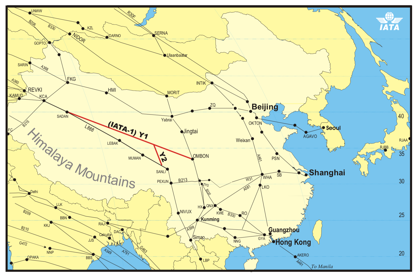
L888 – The Silk Road Airway

We received this interesting question this week:
We said: “There are four airways over the Himalayas (L888, Y1, Y2, Y3) which the Chinese authorities will only let you use if you have ADS, CPDLC and satellite voice communication, and operators need to verify their equipment with them at least 60 days in advance! So they recommend that only regular scheduled flights apply to use these airways.”
Member said: “We’ve not been allowed to fly these routes, costing time between Europe and Hong Kong. I’ve been unable to get a direct answer of why not from our local Universal Aviation reps except, “the authorities won’t allow it”. Per above, there appears to be a procedure to use these airways. What is the process to gain access to these airways? Our equipment is Gulfstream with everything including the kitchen sink.”
We will start with the answer
The process to apply for access to these airways is found in AIP CHINA Section ENR 3.3.2.4 “L888, Y1, Y2”.
Excerpt from AIP CHINA published by CAAC:
12.1 A formal application shall be submitted to Air Traffic Management Bureau of the Civil Aviation Administration of China before air carriers operate data-link route, the application shall include:
” City pairs;
” Schedules;
” Starting time;
” Type of aircraft used;
” Satellite telephone numbers for the fleet;
” Procedure of emergent escape. (Y1, Y2 exceptive)12.2 Flight plan notification of data-link capability is required before data-link services can be provided.
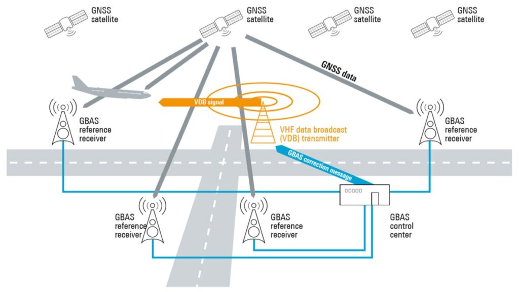
12.3 Aircraft equipped with serviceable ATS data-link equipment shall fill in ICAO flight plan forms as follows: a. Advice of data-link capability shall be included in Field 10 (Communication and Navigation) by using an abbreviation “J”. b. Advice of available data-link media shall be included in field 18 by use of the prefix DAT/followed by one or more letters, as follows:
” DAT/S for satellited data-link,
” DAT/H for HF data-link,
” DAT/V for VHF data-link,
” DAT/M for SSR mode data-link,
” DAT/SAT for satellite phone.12.4 Serviceable ADS equipment carried will be annotated by adding the letter D to the SSR equipment carried.
12.5 Air Carriers are required to provide a list of satellite telephone numbers with each aircraft which flying along route L888, Y1, Y2.
Now, onto the interesting stuff. The process requires submission of a “Procedure of emergent escape”.
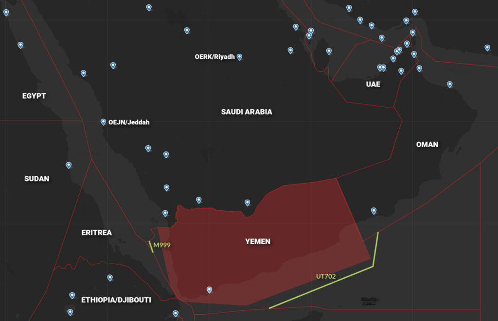
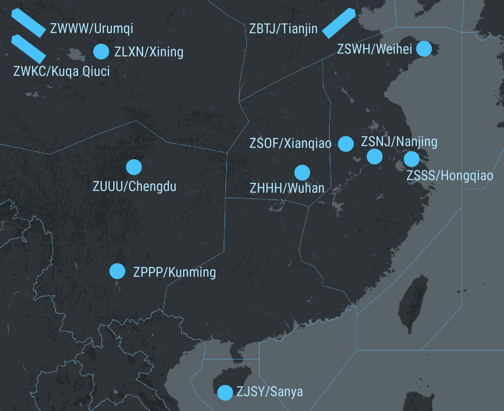
The available alternate airports for route L888 are (according to the AIP);
- ZPPP/Kunming airport;
- ZUUU/Chengdu airport;
- ZWWW/Urumqi airport; and
- ZWSH/Kashi airport.
This is where it can get a little complicated. The handful of “air carriers” authorized to operate over these airways have type specific ‘escape’ procedures such as this example which shows a B777-300ER ‘Depressurization Terrain Considerations’ on Y1.
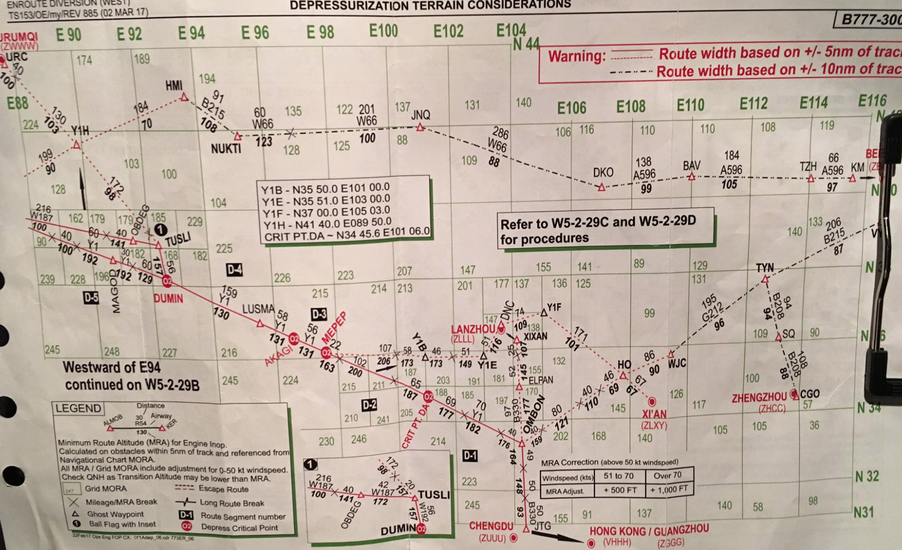
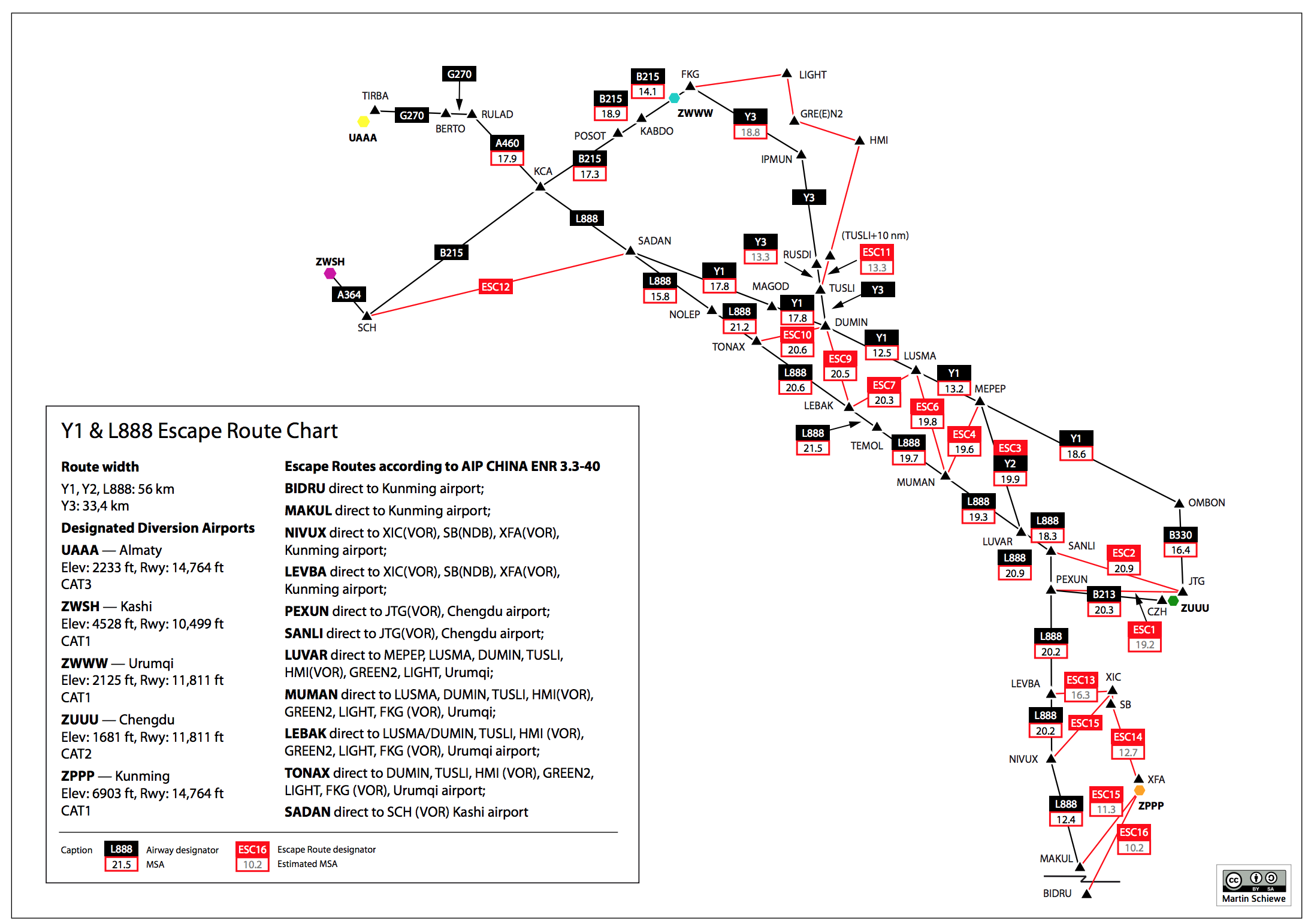
There is also the consideration of additional crew and passenger oxygen. The GRID MORA is over 20,000ft for several hours.
If you’re flying routes over this airspace regularly with the same aircraft, meet the onboard aircraft requirements and are willing to invest in developing type specific escape procedures, then a submission to CAAC might be in order. Even then, it’s a complicated approval process and there is always the potential requirement to carry an approved onboard navigator for travel to certain domestic airports.
Another tip we picked up was to make sure you don’t change callsigns between the submission of your application and the date you fly. Some flight plans have been getting rejected close to departure due to callsign confusion.
Some history…
As you’ll probably already know, the Silk Road or Silk Route was an ancient network of trade routes that were for centuries central to cultural interaction originally through regions of Eurasia connecting the East and West.
The concept behind the Silk Road initiative was not new. As long ago as 1997, the Australian airline QANTAS commissioned a study that crossed part of the Tibetan plateau which determined that there would be substantial benefits for their B747-400 aircraft, and that suitable depressurization escape routes were able to be determined.
As recently as 2013 ICAO was working to expand routes over this airspace:
“ICAO presented information on a possible high density routing initiative for traffic from Southeast Asia or Southern China to Europe via north of the Himalayas, taking advantage of the latest Performance-based Navigation (PBN) navigation specifications. The Silk Road initiative was a proof- of-concept ATS route study, utilising RNP 2, RNAV 2 or RNAV 5 navigation specifications, and was first presented to the Asia/Pacific Regional ATM Contingency Plan Task Force (RACP/TF) as a possible future contingency system for traffic operating on Major Traffic Flow (MTF) AR-4, in case of airspace unavailability in South Asian FIRs.”
Further Reading:
- You can view a great overview of the QANTAS approval process here.
- Airbus also had some interesting insights when they flew a test A380 over the route a few years back including commentary of their application process and hurdles.
- Lastly a great flight safety read about escape route planning and the complexities involved in it.