Bahamas Relief Flights – Operational Summary
Updated Tuesday 9.30am ET
SITUATION UPDATE – 0930 ET Tuesday
Hello all,
We’re standing down. The purpose of our involvement in the Bahamas Relief effort was twofold – to provide an accurate information flow from an aviation perspective, and to help coordinate in some way the massive amount of civil aircraft that started taking part last Thursday.
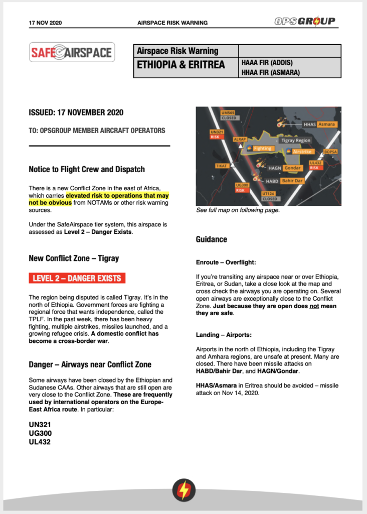
Once the winds had died down on Thursday morning, and it became safe for aircraft to start operations, what we initially saw was a void of information on the situation – which airports were available, and what the approval process from Bahamas CAA/NEMA was and how that worked. Nobody was quite sure. But hundreds wanted to help. So, we made contact with many of the pilots and operators, and Bahamas ATC, to get accurate status reports from Nassau, Freeport, Treasure Cay, Marsh Harbour, and Sandy Point – the five locations where the relief efforts were focused at the end of last week, and got that information out in a twice daily briefing. We also worked with the Bahamas CAA approvals team to get word out on how to apply, and what that process looked like.
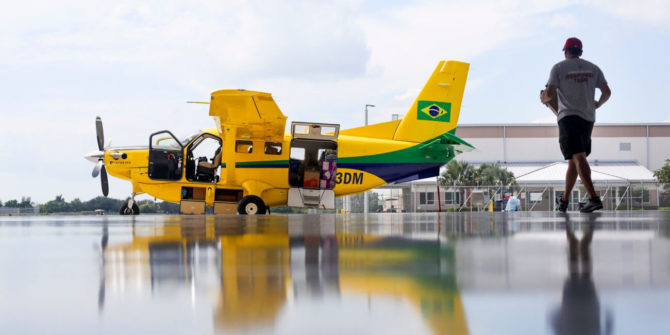
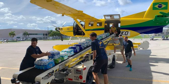
The response from Business and General Aviation was overwhelming to say the least. Hundreds of flights were flown on Thursday and Friday bringing in much needed first-response supplies. The initial situation was challenging – airports had not been secured and there was a rush to get relief items arriving, creating an unsafe security situation for crews in some locations. Nonetheless, efforts continued. It quickly reached a saturation point. There was no ATC, and the entire Abaco area was on one Unicom frequency. Airports that normally have a few movements per hour were seeing in excess of 60 aircraft per hour at times. Some were operating without transponder and radio calls.
On Friday evening, it showed no sign of abating, and airspace safety was now the primary concern. We worked with AOPA and NBAA ATS in an effort to reduce the level of GA traffic, especially as larger aircraft were now coming on scene and could do more to help. Saturday proved to be another exceptionally busy day, and we coordinated with Miami Center to get routes in place to manage that flow of traffic, and get word out to use those routes. Freeport opened up, with limited ATC.
Finally, by Sunday afternoon, there was some respite in the traffic, and the picture of airport status was clear, but there was still a need for coordination among the many separate organizations, and individual operators, conducting relief flights. We worked with Odyssey, Aerobridge, Operation Airdrop, Banyan, numerous FBO’s, the US Coast Guard, and probably 150 individual pilots, all part of the flotilla of floatplanes, helicopters, business jets, and private aircraft helping to bring relief. At the same time, airlines and military were now providing larger aircraft for the mass evacuations from Abaco that we saw Sunday and Monday. The marine relief effort was even bigger.
Throughout, we were in contact with the NEMA coordinator, UN OCHA, Bahamas CAA and ATC – and later, NGO’s – who all did an exceptional job given the extreme circumstances. The geography of the Bahamas was the biggest challenge – scores of tiny Cay’s, and with bridges out and roads washed away, there were – and still are – many pockets of cut-off communities, all needing help.
On Thursday night we started this Facebook group to bring as much information into one place for the operators and pilots involved as we could. It’s been a tremendous success. Thanks to all the volunteers participating, we’ve had a steady stream of updated information on airports and airspace, and more importantly, we’ve been able to coordinate everything from Search and Rescue helilifts, flights for teams of Doctors, medication transport, evacuation flights, and determine very specific locations to bring aid to.
And now? The presence of the UN, the USAF, International Navy vessels, and upwards of 50 NGO’s, all at full tilt, means that the vast majority of relief efforts are being taken care of on a larger scale.
Make no mistake. The situation is still dire. People still need help, in a massive way. Whole towns are gone. The death toll is much higher than than the small numbers first reported. Individual flights can and will continue to make a difference. We’ll keep this group open and running, so you can post and share info. I and the OPSGROUP team will get back to work on what we normally do, but we’ll keep an eye here to help out where we can.
So – a big THANK YOU to every single one of you that has been part of this effort. None of us have slept much in the last five days, and it’s been heartwarming to see the massive generosity of time, effort, aircraft, pilots, and supplies, and help. Simply amazing. Much love to you all!
Mark.
Earlier updates
Hello all,
If you are involved in the relief effort, planning to fly, or have information to share, please join:
FB group: Bahamas Relief Air Coordination

Much of the evacuation effort has been completed. Airports and airspace is now less crowded. SAR efforts continue. The flight of ‘general’ supplies in from GA is winding down. Some communities have made the decision not to be evacuated, and these will need resources. There is still an unfolding humanitarian crisis. We know that the death toll will rise significantly.
We now move to more specific tasked requests for aviation help. There are swarms of NGO and Relief Agencies in Nassau and the islands. Many need very specific help with things, and it’s clear from this evenings NEMA meeting and NGO coordination meetings, that support from the GA community, and private operators, will continue to be extremely useful.
It’s been a real challenge here for us to strike a balance between getting help where it’s needed, and not having too many respond to the same airports, which created the unsafe airspace situation we saw over the weekend.
We’ll continue to work on getting latest info out, so that from an air ops perspective you have the current status. With that, we’ll also continue to work with the NGO’s and NEMA to bring in private air support wherever we can. Please continue the great work here! Well done everyone.
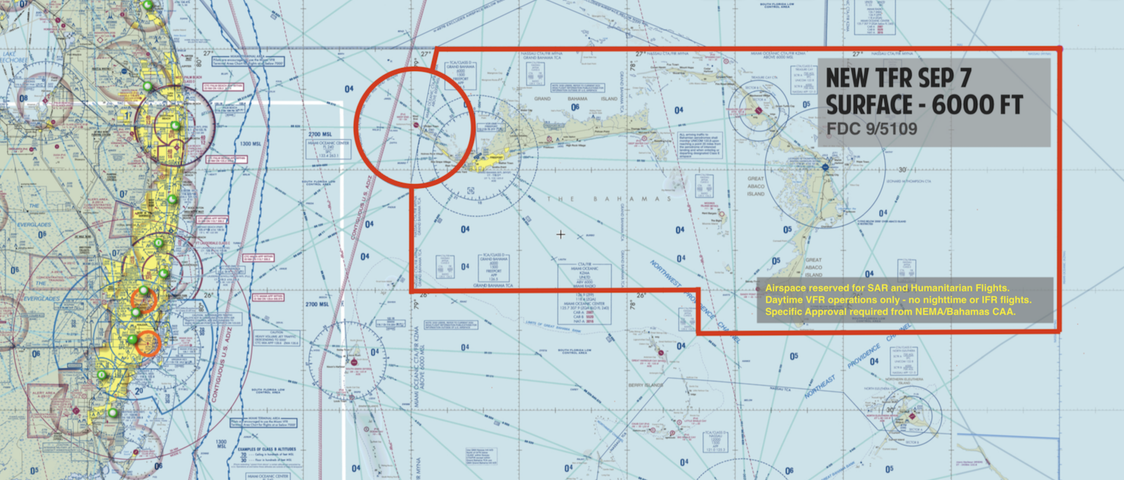
A new TFR has been issued Sunday morning restricting flights – see below.
There is very clear risk in too many aircraft operating here. Please share this, and get the word out as best you can. This is an exceptional situation, and if you can get this message to anyone thinking of flying, please do.
The operational situation in the northern Bahamas is still complex and changing continuously.
We’ve monitored the situation continuously, and have discussed with and received intel from many agencies including Bahamas and US ATC, FAA, BCAA, NEMA, USCG, Military, the NBAA, as well as a number of pilots that are currently operating there in a government and recon capacity.
New TFR for the Bahamas – Sunday
There is a new TFR (Restricted Airspace) issued early Sunday morning for the Bahamas, valid through until 1st Oct.
Key points:
– New TFR issued Sunday am
– Restricted area boundaries changes
– Surface to 6000 feet.
– Daytime VFR ops allowed only, no night ops or IFR.
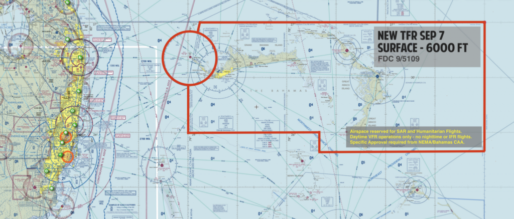
Full Text – original TFR here
Overall picture
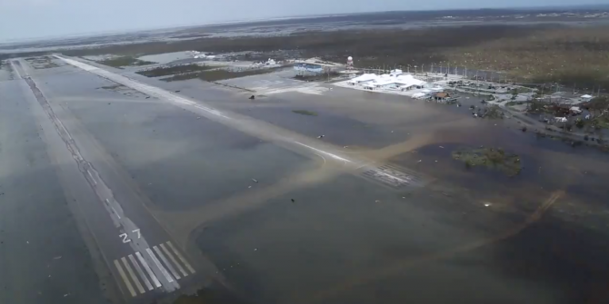
There are two primary areas where relief operations are currently happening – Abaco and Grand Bahama. Large parts of the islands have been wiped out, much flooding remains, roads are out, and the situation on the ground is very challenging. The focus at the moment is on evacuation – getting people out. The airspace picture is worrying. We’ve received reports of aircraft operating at low level without transponder (presumably because they don’t have approval to be there), creating a collision concern. There are many more aircraft than usual in Abaco, meaning the airspace is crowded in places, and there is no ATC. There is a TFR active, approval is required from NEMA, see below.
Before you go
Please consider the following carefully:
1. The airspace in Abaco is already overcrowded. The US Coast Guard, government aircraft, and approved relief flights are all operating to, from, and over the island. There are many more helicopters and fixed wing aircraft here than usual.
2. Some aircraft are operating without transponders, and may not be making radio calls, to avoid being pinged for operating without approvals.
3. Help is needed, but it has to be delivered sensibly. If you are going to go, you must request permission from NEMA/The Bahamas CAA. See below for contact details. Consider the safety of your own aircraft and pilots first, then others, and only operate with permission – or you are likely to jeopardize the relief effort as a whole.
4. There is a TFR for the entire Northern Bahamas. All aircraft require approval from NEMA. See below.
5. The situation changes hour by hour.
6. Miami ATC have published very specific preferred VFR and IFR routes. Check them carefully. See below for details. Especially if you are IFR, make sure to file the correct route – not doing so is creating issues for Miami.
7. Read these tips on Relief flying from the NBAA, and if you haven’t already, sign up for the Hero Database. Better to work with a larger organisation with coordinated relief efforts than trying to fly a single mission on your own.
Current Operational Information
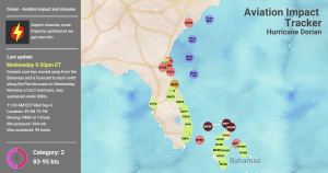
All the information that we have on Bahamas airfield status, permissions, fuel, customs, and general situation is at the Aviation Impact Tracker.
Getting permission to go
NEMA approval is necessary for operations to Abaco and Grand Bahama. It’s being managed by the Bahamas CAA.
Situation:
– The CAA and NEMA Teams are still at capacity trying to handle relief flights, but the essential ones are getting approvals. There is a team of 3 working right now through all requests.
– The airspace, particularly GB and Abaco area, is very busy. There are many aircraft operating on humanitarian relief missions.
– They ask that we get the word out that following the procedure, step by step, is the best way to help right now.
Procedure:
– All relief flights must request approval
– If you are planning a flight to the Bahamas, plan to fly to Nassau first. Clear customs there. If you are given approval to fly onwards, then do so from there. Only exceptional cases will be allowed to operate direct to GB and Abaco from outside the country.
– Use email as the first method of communication, rather than phoning them. Email the form to them with the first request.
tamiko.johnson@bcaa.gov.bs, Ladario.Brown@bcaa.gov.bs, Juliea.Brathwaite@bcaa.gov.bs
– If approved, you will get a TFR Number. Put this in your Flight Plan.
– Bahamas CAA are present at the out islands. Do not try to fly direct without authorization, do not operate without a transponder, or without radio calls. This seems obvious but some are doing this.
Reminders:
– There are MANY relief operations happening right now. Before adding your aircraft to this, consider whether it may be more helpful to send your load via a larger operation, or boat. Each additional aircraft increases the complexity.
Bahamas airports – current status
MYNN/Nassau is operational, but seeing increased traffic from the relief operation, including a lot of helicopters – not the norm for the Bahamas. Bear that in mind. Coordinate with the airport before you depart.
For the current status of Abaco and Grand Bahama airports, please check the Impact Tracker.
Most of the other unaffected airports are now operational, with the exception of Bimini, which is, we believe, planning to open Thursday morning.
See the latest on the Impact Tracker.
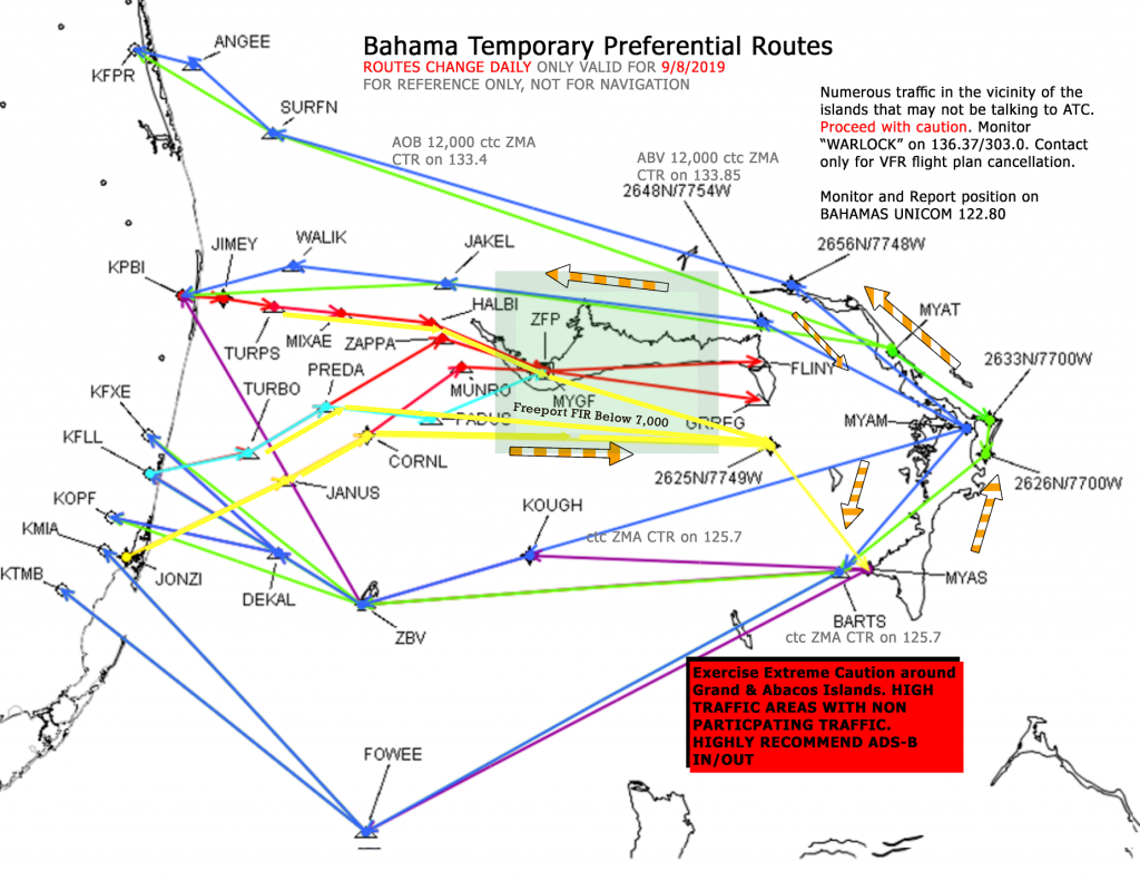
Routes to the Bahamas
Miami ATC are very up to speed on the whole situation, and have published some Preferred Routes (including which way to fly around the islands), as per the map here. The routes are being issued by Notam (KZMA is the identifier), and although the current set have been issued through to 4th Dec, these may change – so keep an eye on the Notams.
Please get the word out to IFR departures from Florida FILE AND FLY THE CORRECT ROUTE out to the Bahamas. There is a large volume of traffic and not filing/flying the correct route is creating a big issue.
From Miami Center: All aircraft arriving Bahamas must be at or above 7,000 FT. VFR aircraft should be +500 feet and proper altitude for direction of flight. If an aircraft cannot climb above 7,000 ft, they will be asked to hold and for pilot’s intentions prior to entering MYGF approach. Due to limited radar coverage northeast of ZFP ALL MYAT/MYAS/MYAM bound aircraft must be above 9,000 until clear of Freeport FIR.
Aircraft unable to maintain 9,000 can expect 7,000 feet will be terminated and handed off to Freeport approach, traffic permitting. Limited radio and radar coverage North and East of Freeport. Limited radio and radar coverage over Abaco Islands.
Aircraft may be instructed to monitor “WARLOCK” frequencies 136.37/303.0. Contact only for cancellation of VFR flight plan. The Bahamas Unicom frequency is 122.80, monitor this frequency and report positions.
This is the map for routes on Sunday Sept 8th. Routes for Monday and the week may be different, so check that Notam carefully!
Inaccurate CNN Reports
Many of you will have seen the reports from CNN, which have now been spread widely on Social Media, declaring that Freeport Airport is “gone”. This is not true. The CNN report was filmed in the Western Air terminal, not the main airport. The damage shown was to that facility. Although the airport terminal has been partly damaged, runways are OK, and the airport is open.
If we can help
Please just email us at team@ops.group and we’ll do our best to answer questions or point you in the right direction. There are a lot of relief efforts happening, and we’re doing our best to provide coordinated, useful, and accurate information for you.


 Specifically, these FIR’s:


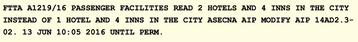
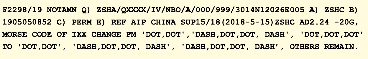
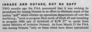
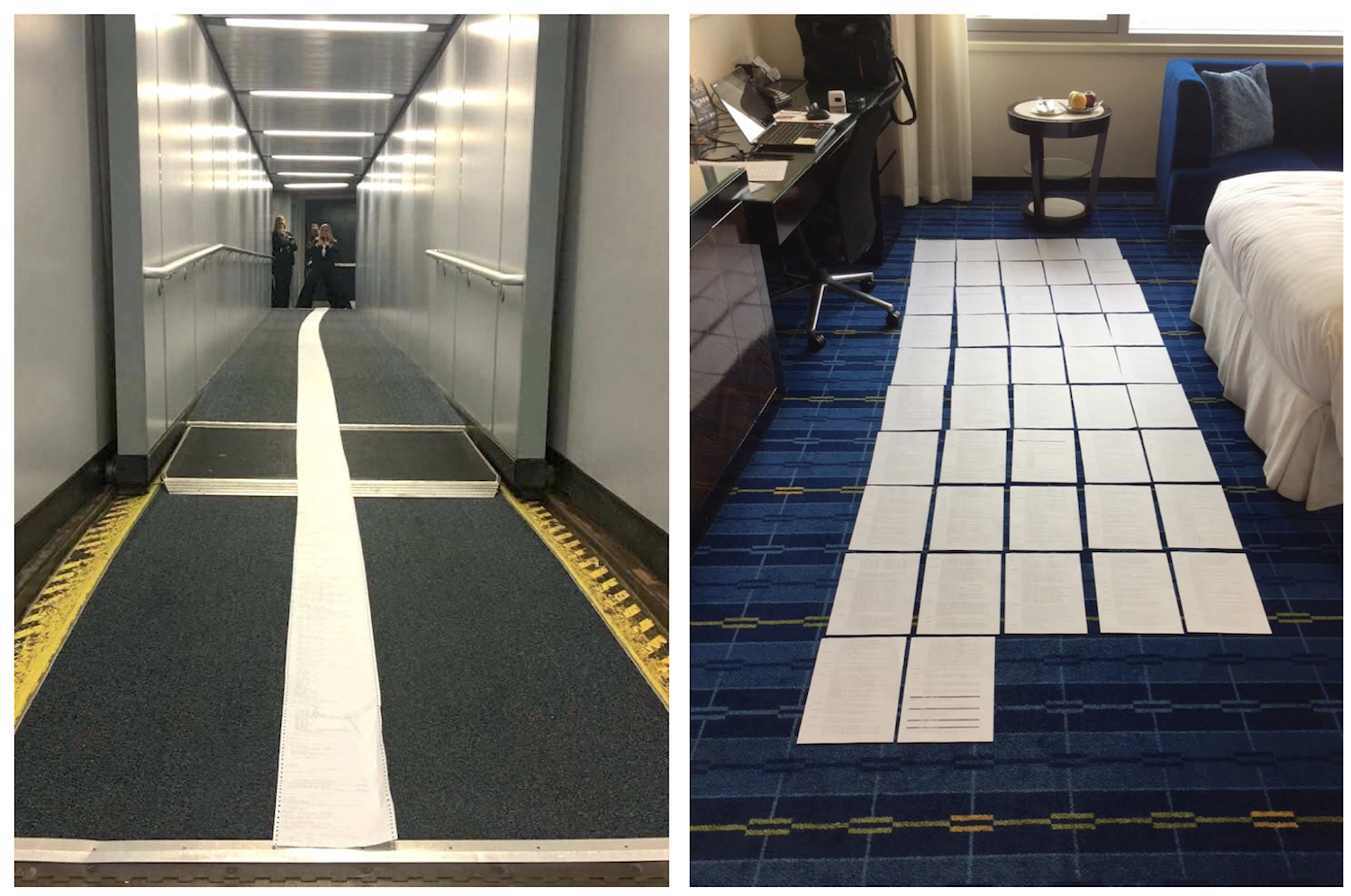 That is the average size of the Notam Briefing package that each crew is given. And so, your job as a pilot at briefing time, is to find the one Notam that will end your career or endanger the aircraft, in a package the same size as a short novel. Buried deep in Birds of Bangkok, War and Peace by Greece and Turkey, Unlighted Tiny Obstacles, Goat grazing times, Grass cutting timetables – is a runway closed, a diversion airport unavailable, a decision height changed. And you’ll miss it.


