GoCrow – Planning map & Route report
Welcome to GoCrow – the OpsGroup route analysis map. Use GoCrow to plan a route that’s coming up: see the latest alerts (including SafeAirspace warnings), get some basic performance figures (fuel, distance, time), check permits required, and see what others have said about your route.
Then, launch GoCrow and just enter a departure and destination airport, and choose your airplane. When you press “Route“, you’ll get a great circle track with enroute alternates, alerts, permit information, and member ‘Spy Reports’.
Search radius Default is 150nm either side of your track
Intl airports only Will display only Airports of entry
Runway length will show only airports longer than this.
The route displayed will be a simple “as the crow flies” track. To change the path to avoid certain countries, or follow a specific route, click the yellow line to get white circles, and then drag any of them. The data will then be recalculated. These are rudimentary planning numbers to give you a quick synopsis.

Dist This is an airway distance, using a simple 105% of great circle.
Gspd Groundspeed – best guess for your route. This isn’t date specific, so forecast winds are not in here, but it does make a best estimate according to your direction of flight. Eastbound is always going to be faster than westbound.
Block Time Distance/Speed from the first two, adjusted for taxi time, climb and descent.
Fuel Burn Using a simple first hour, subsequent hour burn rate for the airplane type.
GC Track Great Circle track.
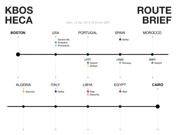
Alternates that may be suitable are displayed along the route, with an icon to show if there is a recent alert for that location.

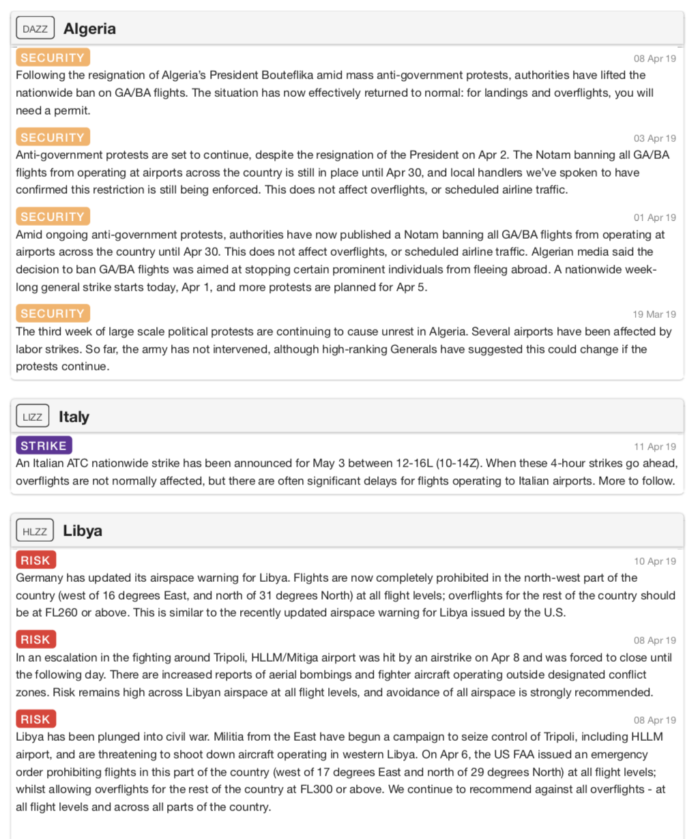
The news tab will give you ops alerts from the last 30 days as default, or you can set a longer period for additional info.

The permits tab will give you the lowdown on that country, how to get a permit, and which types of operation (private, commercial) need a permit.

The Airport Spy tab will pull all reports for your route that OpsGroup members have filed. Click on the airport name, or use the link icon, to go the Airport Spy page for that location and read all reports.
If you get a risk warning like this, then check the SafeAirspace map in your dashboard for full details.

Once you click on the country, you’ll see all warnings, Notams, and data for that airspace.


When you’ve found the route you want, you can print a Route Briefing
This will put all the ops alerts for your route into one PDF that you can download, print, or email.
Adding an aircraft
If you don’t see your aircraft type in the dropdown, then just send this data to team@ops.group and we’ll add it in:
- Aircraft type
- Groundspeed (at cruise, 75% max weight ideally)
- Fuel Burn for first hour
- Fuel Burn for next hour
For example: B737, 470 kts, 8400 Lbs, 6000 Lbs.
Links
