Key Points
- The forecast for Hurricane Idalia has been upgraded. It is now expected to be a Category 4 hurricane when it makes landfall over Florida’s northern panhandle on Wednesday morning.
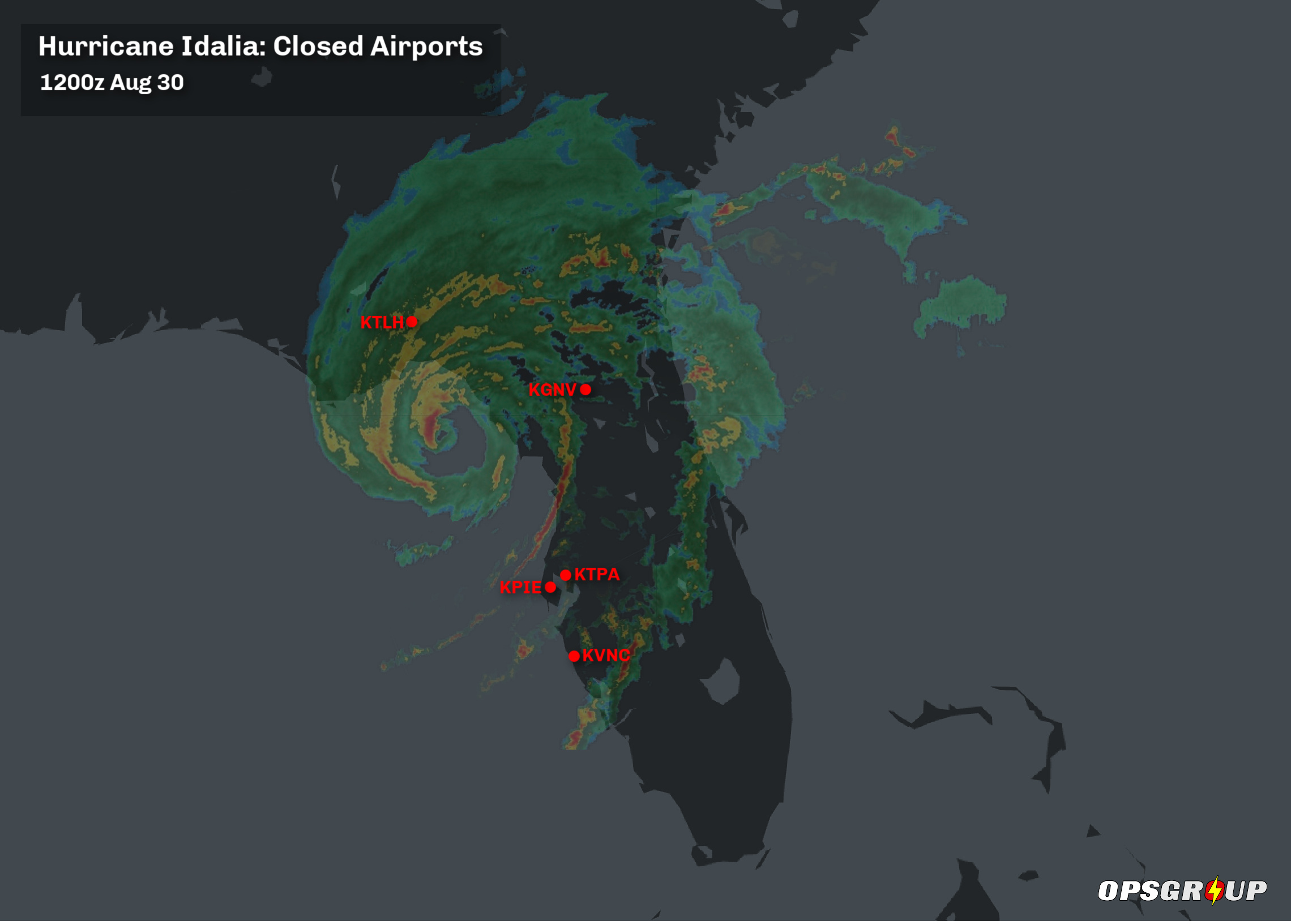
- Several airports are closed: KTPA/Tampa, KPIE/St Pete-Clearwater, KVNC/Venice, KTLH/Tallahassee, and KGNV/Gainesville. Expect closures to be announced at other airports in the region too.
- Hurricane warnings have been issued for the majority of the state’s Gulf Coast.
National Hurricane Center’s Advisory, issued 1200z Aug 30:
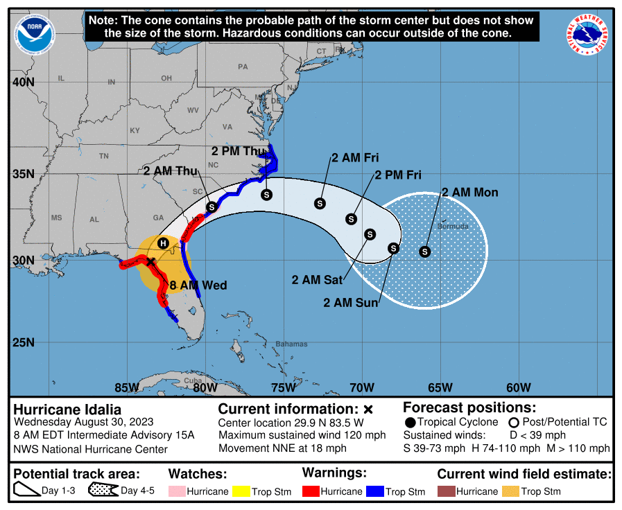
At 800 AM EDT (1200 UTC), the eye of Hurricane Idalia was located by
Tallahassee radar near latitude 29.9 North, longitude 83.5 West.
Idalia is moving toward the north-northeast near 18 mph (30 km/h). A
north-northeastward motion is expected through the morning, with
Idalia's center forecast to move into southern Georgia later today.
Idalia is forecast to turn toward the northeast and east-northeast,
moving near or along the coasts of Georgia, South Carolina, and
North Carolina late today and Thursday.

Maximum sustained winds are estimated near 120 mph (195 km/h) with
higher gusts. Idalia is a category 3 hurricane on the
Saffir-Simpson Hurricane Wind Scale. Although Idalia will weaken
further now that the center is inland, it is likely to still be a
hurricane while moving across southern Georgia, and near the coast
of Georgia or southern South Carolina late today. Idalia is forecast
to be a tropical storm while moving near the coasts of northeastern
South Carolina and North Carolina tonight and on Thursday.

Hurricane-force winds extend outward up to 25 miles (35 km) from
the center and tropical-storm-force winds extend outward up to 175
miles (280 km).

The minimum central pressure is 950 mb (28.05 inches) based on
aircraft data.

Water levels along the coast of the Florida Big Bend continue to
rise rapidly. A NOAA National Ocean Service tide gauge at Cedar
Key, Florida, recently reported a water level of 6.2 feet above
mean higher high water, which is an approximation of inundation in
that area.
Airport Closures
Several airports across the region will close for the passage of the storm. Here are the ones we know about as of 1200z on Aug 30:

And here are the Notams that carry the announcements of the closures:
KTPA/Tampa
08/255 – AD AP CLSD EXC EMERG ACFT AND MIL OPS AND LIFE FLT. 30 AUG 12:10 2023 UNTIL 30 AUG 21:00 2023. CREATED: 30 AUG 12:10 2023
KPIE/St Pete-Clearwater
(A0740/23) – AD AP CLSD. 29 AUG 19:00 2023 UNTIL 30 AUG 19:00 2023. CREATED: 28 AUG 17:27 2023
KVNC/Venice
08/354 – AD AP CLSD. 30 AUG 11:57 2023 UNTIL 30 AUG 18:00 2023. CREATED: 30 AUG 11:57 2023
KGNV/Gainesville
(A0547/23) – AD AP CLSD EXC EMERG ACFT AND LIFE FLT AND MIL OPS AND SKED ACFT 1HR PPR 352-262-6691. 30 AUG 10:45 2023 UNTIL 31 AUG 02:30 2023. CREATED: 29 AUG 21:03 2023
KTLH/Tallahassee
(A0665/23) – AD AP CLSD EXC EMERG ACFT AND SAR AND MIL OPS AND LAW ENFORCEMENT AND CARGO 1HR PPR 850-891-7830. 30 AUG 03:00 2023 UNTIL 31 AUG 08:00 2023. CREATED: 29 AUG 16:24 2023
More info
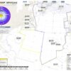
- Cyclocane have a tracker page for the hurricane here, which includes tracking map and source info from the National Hurricane Center.
- The FAA have a page on airport closures here. They have activated telcons for Idalia at 1230Z and 2200z each day – you can find dial in deets on the NASS website.
- The NBAA have a page on the hurricane here, which includes airport closures, equipment shutdowns, and route info.
If you have any additional info to add, please email us at news@ops.group
More on the topic:
- More: Hurricane Milton – Florida Under Warning
- More: Hurricane Beryl
- More: Hurricane Season Approaching: What’s in store for 2023?
- More: Hurricane Freddy: Still going strong
- More: Hurricane Nicole: Florida Airport Closures – Nov 10 1000z
More reading:
- Latest: Gander’s Bringing Back CPDLC Oceanic Reroutes
- Latest: EU Temporary Admission of Aircraft – Busting Myths
- Latest: US Ops Update: Speeds, Squawks and Slippery Runways
- Safe Airspace: Risk Database
- Weekly Ops Bulletin: Subscribe
- Membership plans: Why join OPSGROUP?