Crossing the Quiet South: From Australia to Argentina

Every so often, a question drops into our inbox that reminds us just how big and how quiet parts of the world still are.

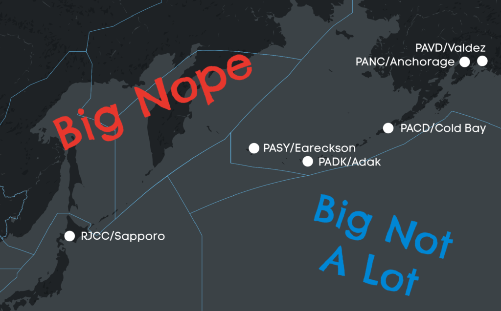
Not long ago, someone asked about flying from Australia to the southern tip of Argentina. It’s a trip across one of the most isolated parts of the planet: long stretches of ocean, few places to land, and very little room for error if something changes. There isn’t much written about it, and only a small number of crews have done it.

We checked with the OPSGROUP community and heard back from several operators and trip support teams who have made the crossing. They shared where they routed, where they stopped, and what they learned along the way.

This short guide brings together what we know so far, and we’ll keep adding to it as more of you share your experiences. If you’ve flown anywhere in this region, we’d love to hear from you at team@ops.group.
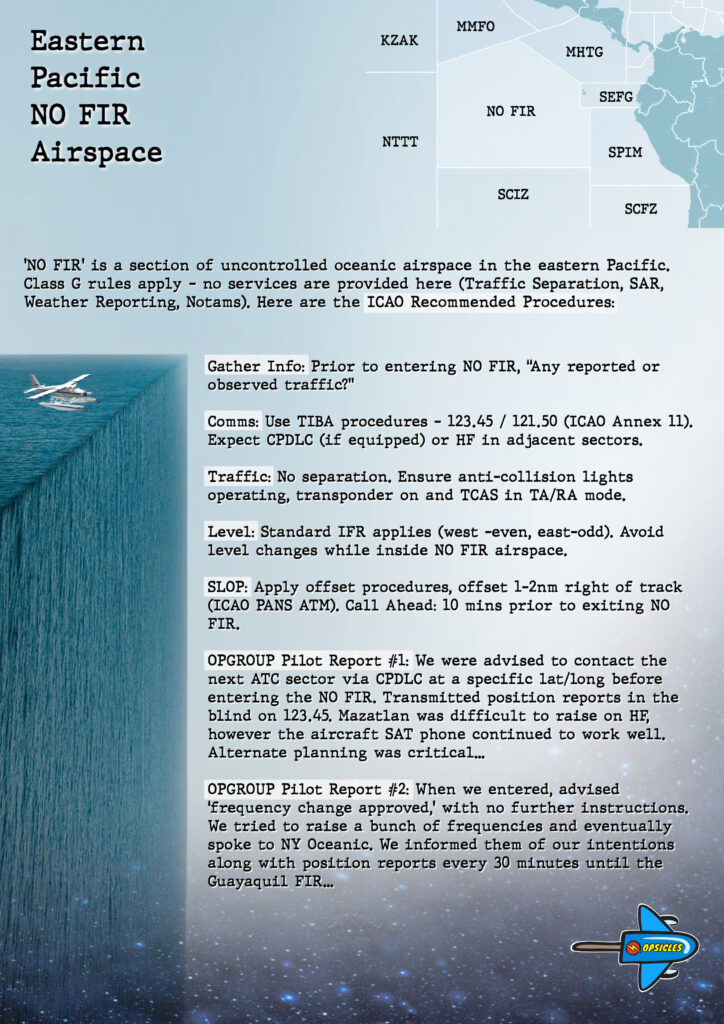
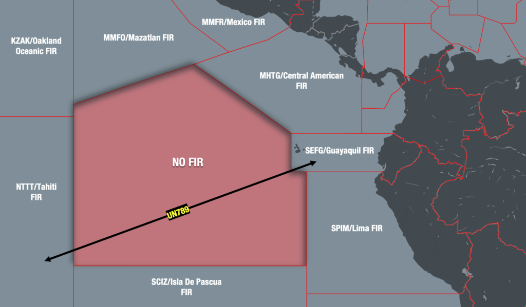
Few Places to Land

Once you leave Australia and head east across the South Pacific, things get quiet very quickly. It is a huge region with many small nations and islands, but only a few airports have long enough runways and operate around the clock. Many smaller fields have little or no parking, and fuel is not always guaranteed. Communication can also be slow, as email exchanges with local FBOs or authorities often take time, so it helps to plan well ahead.

Finding suitable alternates is another key challenge. Distances between usable airports are long, and ETOPS planning can be complex. Some crews recommend keeping about five degrees of spacing between waypoints to make navigation and decision-making easier. There are also a few US military airfields in the region, such as PGUA/Guam and PKWA/Kwajalein, but these are not open to civilian traffic.

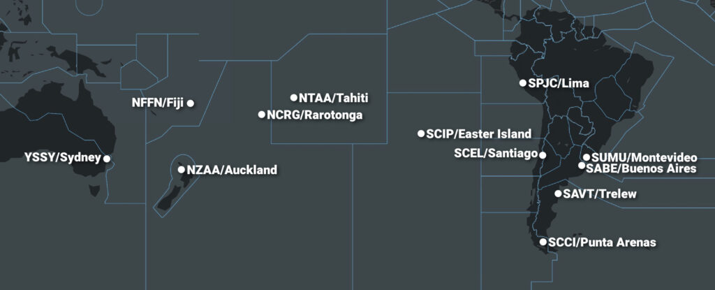
SCIP/Easter Island is the only true mid-ocean option. To the west lies NZAA/Auckland, and to the east SCCI/Punta Arenas marks the entry into South America. Antarctica may look close on a map, but it is not a realistic option because there is no fuel or services, and diversions there are reserved for real emergencies.

Most operators who have crossed the Pacific follow a similar island-hopping route:

YSSY/Sydney → NTAA/Tahiti → SCIP/Easter Island → South America (SADF, SCCI, SUMU)

Trans-polar routing is not practical for most bizjets, so this Polynesian path remains the preferred choice.

Many of the islands that can handle larger bizjets are not open 24 hours and often require slots or PPR. Last-minute diversions are rarely possible, especially in Polynesia. Even the main stops such as NTAA/Tahiti and SCIP/Easter Island can face full airport or runway closures at times. On Easter Island, handling is provided by a single agent with limited services, and cash may be preferred. Other alternates, including NCRG/Rarotonga, have similarly tight hours, so it’s best to check schedules and requirements well in advance.

Fuel shortages are uncommon (except for NCRG/Rarotonga, which has one now and then when the fuel tanker is late to arrive at the island), but arranging fuel releases in advance is always sensible. Permits and visas can also take extra time depending on the country, so it helps to build that into your schedule.

Comms and datalink are generally reliable, although one crew reported a four-hour satellite internet dropout west of Easter Island. Light turbulence can occur in the low 40s, especially during the Southern Hemisphere winter.

Once you reach the mainland, things become much easier. Handling in Chile and Argentina is efficient, fuel is reliable, and services are good. On the islands, operations are simpler but still manageable with good coordination.

How different aircraft made the trip

Several long-range bizjets have flown this route. Here are examples of routings that worked in practice.

Challenger 350

SADF/San Fernando → SCIP/Easter Island → NTAA/Tahiti
NTAA/Tahiti → SCIP/Easter Island → SADF/San Fernando
Possible with careful planning around alternates and timing.

Falcon 7X

SABE/Buenos Aires → SCIP/Easter Island → NZAA/Auckland 
YSSY/Sydney → NTAA/Tahiti → SABE/Buenos Aires
SADF/San Fernando → SCIP/Easter Island → NFFN/Nadi
NFFN/Nadi → SCIP/Easter Island → SADF/San Fernando
A flexible option with enough range to connect Polynesia with South America comfortably.

Global Express

SAVT/Trelew → NFFN/Nadi
Has no trouble with the longer Pacific legs, and Fiji works well as a fuel stop.

Gulfstream G550/G650

YSSY/Sydney → NTAA/Tahiti → SADF/San Fernando, SCCI/Punta Arenas
A straightforward option via Tahiti that keeps legs comfortable.

Airports along the way

A quick look at the key tech-stops, listed east to west, from Australia/New Zealand toward South America.

🇦🇺 YSSY/Sydney – Australia

The airport runs H24, though there is a strict 2300-0600 LT curfew. Handlers can request exceptions, but these are not guaranteed. FBOs can usually arrange CIQ directly on site. Fuel is tanker only, so plan large uplifts in advance. Slots are required. Expect standard Australian disinsection rules and have the empty spray can ready on arrival.

Jet Aviation closed its doors permanently on Nov 30, so ExecuJet is now the only FBO at the field moving forward.

FBO contact: fbo.yssy@execujet.com

🇳🇿 NZAA/Auckland – New Zealand

Another solid H24 tech stop just across the Tasman. The airport stays open all day, with short runway maintenance early on Monday and Saturday from 0130-0430 LT, which sometimes does not appear in Notams. Private flights under Part 91 do not need permits, while charter flights under Part 135 require CAA approval. CIQ operates around the clock, and fuel is available with notice, although last-minute uplifts can be slow during busy hours. New Zealand enforces strict biosecurity, and cabin disinsection is mandatory, but quarantine staff can handle it on arrival if needed.

FBO contact: fbo.nzaa@execujet.com, anz_info.s.e.a@swissport.com

🇫🇯 NFFN/Nadi – Fiji

A smooth 24-hour tech stop and refuel point midway between Polynesia and South America. The airport and customs run H24, fuel and handling are reliable, and turnarounds are quick. Wildlife can be active at dawn and dusk, but otherwise ops are straightforward.

FBO contact: info@fijiairports.com.fj, fbo@ats.com.fj

🇵🇫 NTAA/Tahiti – French Polynesia

The only international airport in French Polynesia and the main South Pacific stop. NTAA runs H24, though through early February non-based BizAv (private and charter flights) face limited operating windows matching airline peaks. Movements in those periods need airport manager approval, and use as a diversion is restricted to locally based or pre-scheduled aircraft.

For example, TASC FBO confirmed full 24/7 support on the north side, including CIQ pre-clearance on arrival. They handle disinsection if needed and provide fuel exclusively under the Petropol ExxonMobil brand. Occasionally, filing flight plans through the ARO can be difficult, so it’s recommended to send the FPL by email to seac-pf-bria-bf@aviation-civile.gouv.fr and wait for confirmation.

Landing permits must be requested by operators via the French Polynesia CAA portal (72 hours for private flights, 14 days for charter). Nearby NTTB/Bora Bora  and NTTR/Raiatea are domestic with limited hours and fuel, making NTAA the only reliable international option in the region.

For details on current NTAA restrictions and seasonal procedures, see our dedicated article here.

FBO contact: nuutea@tascfbo.com, ops.ei@airtahiti.pf, ulric.allard@airtahiti.pf

🇨🇰 NCRG/Rarotonga – Cook Islands

A small but reliable entry point between French Polynesia and South America. ATC hours rotate and are published by Notam, with controllers available on request for diversions at +682 25890 or +682 71439. A landing permit is required about 14 days in advance via the CAA, and CIQ is available anytime by prior arrangement. Most nationalities receive a 30-day visa on arrival. Fuel is supplied by Pacific Energy and currently limited for non-scheduled flights. There are two international stands, and overnight parking requires a towbar.

FBO contact: ross.warwick@airraro.com, savage@airportauthority.gov.ck, nikautangaroa@airportauthority.gov.ck

🇨🇱 SCIP/Easter Island – Chile

A key mid-Pacific stop that works well for fuel and rest but needs careful planning. The airport operates roughly 0900-1700 LT on weekdays with shorter weekend hours. A landing permit is required, and once approved, it also serves as parking authorization. Fuel from WFS must be requested 24 hours in advance, and all arrivals must complete cabin disinsection and show the empty spray can as proof. Instrument approaches are often unavailable by Notam, so be ready for visual arrivals and plan alternates carefully. Parking is very limited, usually one stand overnight, and the single handler provides basic services, often accepting only cash.

FBO contact: punavai949@gmail.com, edmundserviceseirl@gmail.com

🇨🇱 SCCI/Punta Arenas – Chile

A reliable southern mainland stop. The airport operates H24 with full CIQ coverage. Three runways provide flexibility, the main one being RWY 07/25 (2790 m / 9154 ft). Fuel is available, and parking can be arranged but must be requested in advance due to limited capacity. No slot requirement.

FBO contact: fbo@aviasur.com, ygonzalez@aviasur.com

🇨🇱 SCEL/Santiago – Chile

Another entry point into South America with reliable services and straightforward procedures. The airport operates H24 with CIQ available around the clock. Parking for BizAv is generally available, fuel is offered H24, and there are no slot or PPR requirements.

FBO contact: fbo@aviasur.com, psaavedra@aviasur.com

🇦🇷 SABE/Buenos Aires – Argentina

Busy city entry point operating H24 with full CIQ coverage. According to the FBO, ramp parking is limited to about two hours, so hangar space should be arranged in advance. Fuel is available.

FBO contact: comercial@royalclass.global, info@royalclass.com.ar

🇦🇷 SADF/San Fernando – Argentina

The other BizAv option for Buenos Aires. H24 with no slots, customs available, easy parking, and fuel on site. The single runway 05/23 is shorter at 1690 m (5545 ft), but ops are smooth, making it a popular alternative to SABE.

FBO contact: fbo@flyzar.com

🇦🇷 SAVT/Trelew – Argentina

A useful southern stop when routing toward Patagonia or Chile. The airport is open H24 with fuel available, and customs work on request with a 48-hour PPR, so it’s best to plan ahead to make sure everything is ready on arrival.

FBO contact: ops@aerowise.aero

🇺🇾 SUMU/Montevideo – Uruguay

A solid H24 option for tech stops or entry into Uruguay. The airport offers full customs, long runways, and reliable support, though most parking stands have specific wingspan and pushback limits, so it’s best to confirm space in advance. Fuel is available. Note local noise restrictions prohibiting departures over Montevideo between 2100-0700 LT, except for emergencies or weather-related operations.

FBO contact: fbo@fbo.com.uy, ops@aerowise.aero

Flying between Australia and Argentina is very doable, just not the kind of trip you improvise! The distances are huge, the alternates are few, and every good piece of info makes a real difference.

If you’ve been through any of these airports recently, we’d love to hear your story. You can share it with the community by submitting an Airport Spy Report. It’s basically a little postcard about what happened on the ground so the next crew knows what to expect. Your notes help everyone who sets out across the quiet South.


Updated FAA Oceanic Guides

The FAA has updated its resource guides for the three big oceanic areas of interest: the North Atlantic, the Pacific, and WAT airspace (West Atlantic / Gulf Of Mexico / Caribbean). All three have been updated effective July 2025.

These guides are a good starting point for understanding all the essentials of operating in these regions, and include links to all kinds of useful supplemental information around the main topics for each one.

Click on the pics to check them out.

North Atlantic

Pacific

WAT


To see a timeline of the big changes on the NAT stretching back to 2015 click here.

Opsgroup members can download several NAT guides and a NAT Plotting & Planning Chart via the Members Dashboard here.


Eastern Pacific: Navigating NO FIR Airspace

Key Points
  • ‘NO FIR’ is a section of uncontrolled oceanic airspace in the eastern Pacific.
  • Class G rules apply – no services are provided here (Traffic Separation, SAR, Weather Reporting, Notams).
  • There are some ICAO Recommended Procedures: Contact ATC, use TIBA Procedures, turn on all lights, keep squawking, SLOP, and fly standard levels.
  • Download the OPSICLE below for a summary of the procedures.

‘NO FIR’ at the edge of the world

Well off the coast of Peru in the Eastern Pacific sits a large chunk of oceanic airspace known simply as ‘NO FIR.’ As the name suggests – it is completely unassigned. No ATC agency is responsible for it.

You may not have heard of it, because in almost all cases operators simply avoid it. There are just no procedures out there. And when attempting to find some, more questions are raised than answered.

The problem is that avoidance is beginning to cost time and money. With the establishment of ultra-long-haul routes, and aircraft capable of flying them, fuel is becoming increasingly critical. Especially when you consider that in some case ETOPS certification has now reached a whopping 370 minutes – that’s six hours.

And so OPSGROUP is often asked – how exactly can we operate directly across it? We didn’t know either, so we reached out to ICAO for some answers.

Where can I find the procedures?

This may come as a surprise, but there are none. Because no state is responsible for the NO FIR airspace (yet), there is no AIP to reference.

Until ICAO can successfully delegate this laborious task to adjacent countries, the standard ‘rules of the road’ apply – and none of them are specific to this particular piece of the high seas.

There is some provisional guidance out there, but it is just that – provisional. It is based on a 2019 project to subdivide the NO FIR airspace into pieces managed by Peru, Ecuador, Tahiti and the COCESNA states. This has yet to happen, and was stalled by Covid. ICAO advise the project has been revised but will take more time to implement. Until then, no one is home.

Best practice

So, how do we cross the NO FIR airspace without procedures? We need to rely on best practices instead. Here is what ICAO suggested to OPSGROUP, and it begins with a caution:

No one is responsible for it. It is important to understand the impact of this. There will be no traffic separation, SAR services, weather forecasting or even Notams. You will also need to make sure your insurer is happy for you to traverse this kind of airspace.

Having made the decision to enter however, ICAO recommends the following:

  • Use the information available to you. Before you enter the NO FIR airspace, ask controlling ATC the following question (keeping in mind that English may not be their first language)…
    “Is there any known, or observed traffic?”
    It is possible they’re aware of preceding traffic ahead, or are expecting some to exit. Even partial info, is better than none at all.
  • Use TIBA procedures. Yes, they’re technically for ‘contingencies,’ but the principle remains the same – hear and be heard. You can find those procedures in ICAO Annex 11. What frequency? There isn’t one published for the NO FIR airspace and so ICAO suggests using chat (123.45) or guard (121.5).
  • Be Seen. Turn on all anti-collision and navigation lights, just in case.
  • Keep Squawking. Use your transponder and TCAS TA/RA function at all times.
  • SLOP. Follow Strategic Lateral Offset Procedures to further separate you from oncoming traffic. In other words, intentionally deviate up to 2nm right of your airway. You can find those procedures in ICAO PANS ATM, or ICAO Circular 354.
  • Fly Standard Levels. Stick to even levels heading west, and odd levels heading east. Also avoid changing levels inside the uncontrolled airspace unless it is dangerous not to do so.
  • Call Ahead. At least ten minutes before exiting the NO FIR airspace, call ahead and give the next ATC sector a head’s up you’re coming.

What not to do

Rely on adjacent agencies to take care of you anyway.

The most common misconception out there seems to be that the KZAK/Oakland Oceanic FIR will provide some emergency assistance via CPDLC.

When we reached out to them directly they advised this may be the case for some aircraft transiting the adjacent MMFO/Mazatlan FIR, but this is not the case for the NO FIR airspace – as far as they are concerned, there is no log-on available or any other services available.

Operator reports

So that’s what written on the back of the packet, but what about intel from pilots who have recently flown through it? OPSGROUP reached out to members, and received these reports on what to expect:

OPSGROUP Member: …we were advised to contact the next ATC sector via CPDLC at a specific lat/long before entering the NO FIR. We transmitted position reports in the blind on 123.45. Mazatlan was very difficult to raise on HF, however the aircraft SAT phone continued to work well. Alternate planning was critical. We flew through in day visual conditions, and so weather was easy to see and avoid…

OPSGROUP Member: …when we entered, we were simply told ‘frequency change approved,’ with no further instructions. We tried to raise a bunch of frequencies and eventually got in touch with NY Oceanic (randomly). We just informed them of our intentions along with position reports every 30 minutes until we entered the Guayaquil FIR. I’ve never been able to find further instructions on how to operate in this airspace…

There is no magic bullet

The Pacific’s NO FIR airspace is useable but with careful consideration. The challenges of crossing it can be mitigated, but only with solid contingencies in place.

ICAO’s guidance above is a solid starting point, however it is up to individual operators to decide whether the commercial reward outweighs the potential risks.


Navigating the NOPAC Redesign Project

To revolutionise the efficiency of the North Pacific Route System, the FAA and Japanese CAA have embarked on a journey called the “NOPAC Redesign Project”.

In 1974, when NOPAC was initially born, five parallel routes were drawn for pilots to spend many nights staring into nothingness between Japan and Alaska. If lucky, you would see the aurora borealis or maybe even a mysterious red UFO floating near the ocean 😊

However, it was a dark and quiet journey across the North Pacific for most.

This new project aims to compress four routes into less airspace, leaving pilots more room for creativity and manoeuvrability.

So, fasten your seatbelts and join us on this adventure through the whimsical world of airspace redesign…

Wait! Where are we talking about??

This area, from Alaska, over the North Pacific and down to Japan:

That’s just a big mess of yellow land and indiscernible blue lines

Yep, but thanks to the FAA we have some nicer maps available, showing exactly what is changing…

Phase 1B: The Story Begins

  • The two southernmost routes, G344 and R591, were zapped out of existence on Feb 23, 2023.
  • But for the hoarders, fear not, as the waypoints defining these routes were preserved. Think of them now as magical breadcrumbs to help pilots file their flight plans. This unlocked the airspace south of A590, providing opportunities for User Preferred Routes (UPRs). Free to do as we please, making for a more efficient trip.
  • The remaining three routes are: R220, R580, and A590.
  • Aircraft flying on R220 west of waypoint NULUK must have PBCS (RCP 240, RSP 180 and RNP4 approvals) to operate from FL340-FL400. 

Phase 2: Westbound on Route M523

  • At the end of 2023 (but most likely in Jan 2024), Phase 2 of this redesign will unfurl.
  • Brace yourselves for the birth of a new westbound ATS Route named M523. It is ideally situated between R220 and R580. Think of it like adding a secret passage to an already perplexing labyrinth. But unlike the old routes, M523 will only be open to westbound aircraft operating from FL340-FL400.
  • At this point, R220, M523 and R580 will all require PBCS from FL340-FL400, to ensure lateral separation between aircraft (which is now down to 23nm).
  • Don’t have PBCS? If you are flying a plane lacking these approvals, you can merrily explore R220 and R580 either at or below FL330 or at or above FL410. Do you want something more optimum? Then you can plan eastbound on A590, or a westbound route at least 50nm south of A590.

My head hurts

We’re almost there now, only one more phase to go…

Phase 3: Eastbound on Route N507

  • Cast your mind forward to mid-2024, when Phase 3 reveals itself. Behold the birth of the new eastbound route N507, positioned 25nm south of R580. Emerging from the charts, this route gives pilots more options to zigzag through the airspace. To maintain order amidst the chaos, aircraft operating on R220, M523, R580, N507, and the soon-to-be-deleted A590 waypoints will have to have PBCS.
  • Don’t have PBCS? You can operate on R220 and R580 at or below FL330, at or above FL410. Or you could operate at least 75nm south of N507. PBCS requirements do not apply in this southern airspace extravaganza.

Words words numbers numbers… just tell me what I need to know

A brave new world is appearing in the North Pacific, and to help us navigate the upcoming requirements, aviators should consider obtaining PBCS approvals in advance. Think of them like collecting golden tickets for new airspace adventures. So, dear pilots and planners, prepare yourselves for the challenges and delights that await in the world of NOPAC!

And to read all this information again in its pure, unbridled form, click here for the briefing from the FAA Anchorage ATC team.


Russia Reroutes: Alaskan Airport Options

With Russian airports and airspace now off limits for many operators, what airports across Alaska (and also Asia) are available, suitable, and useable for things like ETOPS alternates, fuel stops, and tech stops?

To be honest, very few! Once you cross into the Bering Sea you are extremely limited in the westerly direction, and probably looking at a far more southerly route initially because of the awkward “extra chunk” of Russia that sticks out the bottom.

Why is Russia off limits?

As part of a range of political sanctions imposed on Russia, several countries have now banned Russian aircraft and operators from their airspace – The European Union along with some non-EU countries, the US and Canada. In response, Russia has banned aircraft and operators of many of these countries from Russian airspace.

The exception, at present, is the US –  Russia has still not officially banned US aircraft/operators from its airspace. However, some local agents are saying that they are not able to provide Russian landing and overflight permits to US registered aircraft/operators, and we’ve had similar reports from some locally based OPSGROUP members. Major US carriers are already avoiding Russian airspace, which is sensible action to follow given the uncertainty.

This is affecting a lot of operators at present, who are now having to route around Russian airspace.

The Alaskan Options

A report on a recent routing from Anchorage to India considered the following airports as possible options.

  • PASY/Eareckson Air Station 
    • 10,004’/3050m x 45m
    • ILS 28 / RNAV 10
    • Fuel and maintenance support unknown
    • More an emergency option that a fuel or tech stop option
    • Talk to them on +1 907-552-3443 / +1 907-392-3361
    • ARFF Cat 7
    • PCN 132/F/A/W/T
  • PADK/Adak
    • 7790′ / 2374m x 60m
    • ILS 23 only
    • Some pretty mean terrain around and windshear warnings
    • Fuel available, maintenance support unknown
    • Talk to them on +1 907-269-0751 / +1 907-592-8026
    • ARFF Cat 01
    • PCN 49/R/B/X/T
  • PACD/Cold Bay
    • 10,179′ / 3102m x 45m
    • ILS 15 / RNAV 33
    • High terrain to the south
    • Gets some serious fog!
    • Fuel available, efficient services here
    • Talk to them on +1 907-532-5000 / +1 907-465-1788
    • ARFF Cat 06
    • PCN unknown
  • PAVD/Valdez (if routing from further east and you don’t fancy Anchorage)
    • 6500′ / 1981m x 45m
    • There are no straight in approaches of 05/23 because there is some serious mountainous terrain here. You need to have trained for this spot before you try it!
    • Talk to them on +1 907-451-5217 / +1 907-835-5658
    • Fuel and minor maintenance
    • ARFF Cat 01
    • PCN 54/F/B/X/T

The major international airpots of Alaska lie further east and aren’t so useful range-wise if routing westbound.

PANC/Anchorage to PADK/Adak is approximately 3:15 hours flying time, or 1900km. PASY/Eareckson Air Station lies further east.

The Asia Options

With Russian airspace now off limits for many operators, aircraft attempting to route westbound from the US (via Alaska) are most likely going to have to take a more southeasterly route initially, bringing them over Japan before routing further into Asia. Past Japan, another southern dogleg (albeit it smaller) is needed to avoid North Korean airspace as well.

The following airport has been recommended by other operators:

  • RJCC/New Chitose (Sapporo) 
    • Multiple runways 9843′ / 3000m x 60m
    • ILS CAT II/III available
    • Major international airport with all the facilities
    • RFF Cat 9
    • Talk to any of the many agent and handler options

The direct distance between PADK/Adak and RJCC/New Chitose is approximately 3,300km

For the pilots and planners

Range, suitability and availability are all going to be a bit of a problem with routes heading this direction. Considerations on weather conditions are probably one of the major things to think about. Your only real option if you need fuel or tech support is Adak airport and then onto Sapporo, depending on aircraft range.

There are limited options available to you if you have an emergency. Plan, prepare and monitor.

Where else?

The full list of airports we’ve heard suggested are as follows:

  • PANC/Anchorage
  • PACD/Cold Bay
  • PASY/Eareckson
  • PAFA/Fairbanks
  • RJCC/Chitose
  • RJAA/Tokyo
  • PADK/Adak
  • PABE/Bethel
  • PAKN/King Salomon
  • RJSM/Misawa
  • PAOM/Nome
  • PASN/St. Paul Island

If you are operating westbound and have been impacted by the Russian airspace bans, let us know what airports you considered at team@ops.group


PBCS – What, Where and How

In Short: The performance-based communication and surveillance (PBCS) framework allows for higher safety standards and more efficient airspace use. If your aircraft already has the equipment and you cross the Atlantic or Pacific Oceans often, it’s worth looking into getting your regulatory approval.

PB… what? It’s a good question. We have so many acronyms in aviation, it’s easy to forget what this one stands for and what it really means. So, let’s try and get to the bottom of it.

What is PBCS?

Official answer:

The ICAO performance-based communication and surveillance (PBCS) framework ensures that emerging technologies for communication and surveillance fully support ATM operations and are implemented and operated safely.

In plain speak:

With the technology already available on many aircraft and in the Air Traffic Control facility, aircraft can now fly closer than ever before, especially over non-radar oceanic airspace.

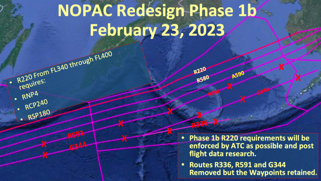
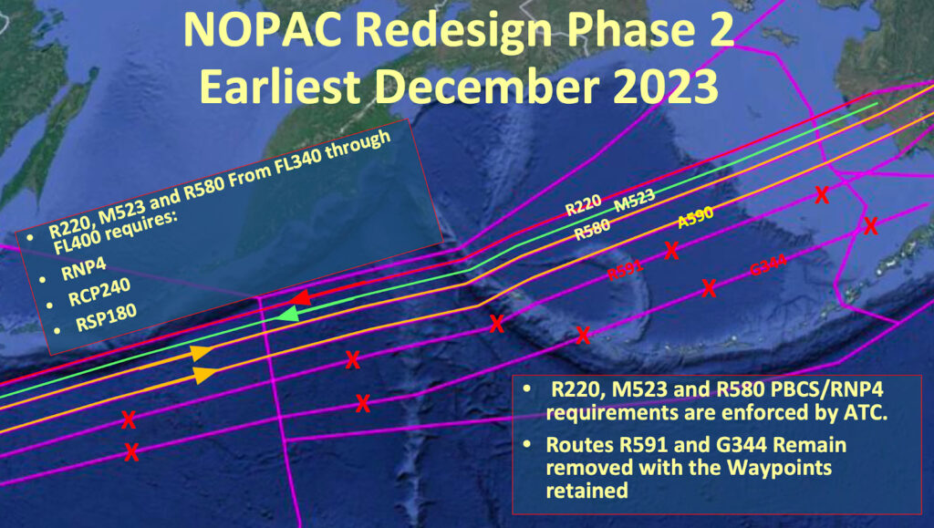
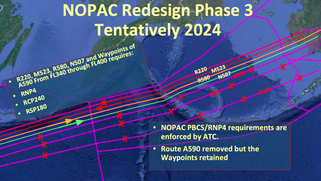
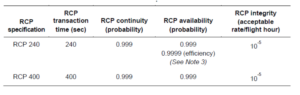
There are two key buzz words, so let’s define them. They are interlinked with RNP – Required Navigation Performance.

  • RSP – Required Surveillance Officially known as “surveillance data delivery”, often stipulated in the Airplane Flight Manual. Basically, how often does the aircraft send its position to ATC/ground station. There are two specifications, RSP180 and RSP400. The numbers indicate the maximum number of seconds (180 or 400) for the transaction to occur.
  • RCP – Required Communication ICAO has two specifications, RCP240 and RCP400. Again, the numbers indicate the maximum number of seconds (240 or 400), or “transaction time” taken for the controller to issue an instruction to the crew and for them to receive a response. This could be via CPDLC, HFDL, VDL or SATCOM.

So, we have a loop here, C-N-S. Communication, Navigation and Surveillance. An aircraft sends surveillance information to ATC about where it is; the aircraft stays within confines of RNP navigation requirements and ATC communicates with the aircraft within the required transaction times.  Pretty easy!

But why do we need PBCS?

The take away? If all given aircraft in a certain airspace have a lower RSP value and a lower RCP value, we can start putting these aircraft closer together.

Essentially – performance-based separation minima. This allows aircraft to be separated safely according to technological capability rather than “one-size-fits-all” prescriptive distances.

What are the differences from PBN?

They are similar but there are notable differences. In a simple sense, the PBN (RNP/RNAV) only requires that the operator obtains approval because it focuses on how the equipment works. PBCS (RSP/RCP) however requires the involvement and approval of the air traffic service provider because it’s a two-way communication and surveillance effort. There are dependencies and complexity with the equipment standards on both ends.

In this graphic you can see a high-level summary of who is responsible for what:

Where is it in place?

Currently PBCS is in effect in one form or another in the following FIR’s

  • NZZC/Auckland Oceanic
  • NFFF/Nadi
  • KZAK/Oakland Oceanic
  • PAZN/Anchorage Oceanic
  • WSJC/Singapore
  • VCCF/Sri Lanka
  • NTTT/Tahiti
  • RJJJ/ Fukuoka
  • KZNY/New York Oceanic
  • CZQX/Gander
  • EGGX/Shanwick
  • BIRD/ Reykjavik
  • LPPO/Santa Maria Oceanic

The Air Traffic Service providers of China, Brazil and Indonesia have also shown interest to introduce PBCS in the future.

Specifically, PBCS is being used between FL350 and 390 on certain “half” NAT tracks as we have written about before.

What do I need to do?

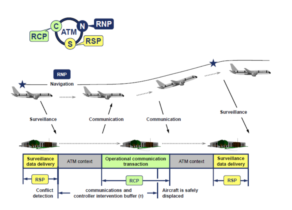
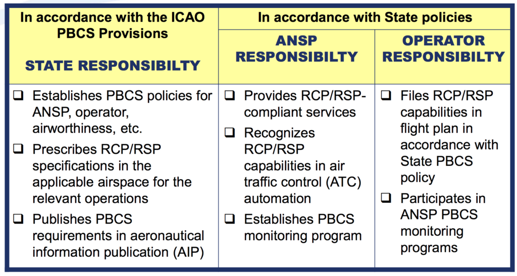
Requirements vary from state-to-state on the exact procedure for obtaining approval. It’s important to note that not all aircraft are automatically PBCS ready (refer to your aircraft manufacturer and your airplane flight manual).

The FAA has outlined its approval process here and has a handy powerpoint document here.

An important element is to prove that you have signed the “PBCS Global Charter” which can be found at the FANS Central Reporting Agency (CRA) website.

When a PBCS authorization is obtained an operator is required to file both P2 (indicating RCP240) in item 10 and SUR/RSP180 in item 18 of the flight plan, in addition to the J codes for CPDLC and D1 or G1 for ADS-C in item 10.

The correct filing of these two codes will indicate to any ATM ground systems applying performance-based separation minima that the aircraft is eligible for these minima and that the crew have received the relevant training in order to safely operate using the reduced separations.

Will you notice that PBCS standards are being applied to your flight?

Ok this is the funny part of this story. The short answer, probably not.

While it may be easier for RCP240/RSP180 approved aircraft to obtain optimal flight profiles, especially during high traffic periods, and particularly for NAT flights using the OTS, the application of these standards is generally tactical in nature for ATC. An aircraft may not have performance-based separation applied at all on an individual flight, or possibly may never have had it applied to any of its flights. Even if a you have RCP240/RSP180 approvals, if the aircraft nearby does not also have the approvals, the separation standards cannot be applied!

What if I don’t have RCP240 and RSP180 approval?

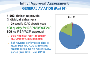
If you do not have RCP240/RSP180 approvals you will always have the larger separations, e.g. 10-min, applied, and not be eligible for the lower standards in cases where it may be beneficial.

The only airspace that has implemented tracks that will require PBCS to file is in the NAT OTS. There are still non-PBCS tracks in the OTS for which PBCS approvals are not required.

All other airspace in which performance-based separation minima are currently applied will allow aircraft with and without RCP240 and RSP180 approvals to enter and use the airspace in a mixed-mode operation.

Will I be penalized if I don’t have it?

Probably not in the short term. In the future as more and more airspace corridors become PBCS only, then it is possible you may be subject to reroutes, delays or the requirement to fly outside of certain flight levels.

So, our conclusion?

PBCS is a great step forward in maximizing efficiency in a busier airspace environment thanks to the advent of better technology. If you fly the NATs often and have an aircraft capable of PBCS certification standards, then yes – do it! The approval process is not overly burdensome, and many modern transatlantic jets already meet most of the technical requirements.

Ultimately, reduced separation standards mean more great air-to-air views. So, pack your camera!

Did we miss something, or does something need more explaining? Let us know!

Extra Reading:


Midweek Briefing 13JUL: South Sudan off limits, New Zealand airport strike off

South Sudan off limits 13JUL The security situation in Juba, and South Sudan, has deteriorated in the last week, with HSSJ/JUB becoming off limits due to fighting. Read the article.

New Zealand airport strike off 13JUL A planned strike by Aviation Security across airports in New Zealand, which would have led to wide scale disruption, has been called off at the last minute. Read the article.


BGBW/Narsarsuaq Current hours are Monday to Saturday 1000-1900Z. If you want to plan a visit outside these hours, or even use BGBW as an alternate, get permission from bgbw@mit.gl in advance. There will be additional costs, especially heavy on a Sunday.

SBZZ/Brazil is the latest country to wield the threat of shooting down aircraft. Last month we reported on the same language from Sudan, in reference to overflight permits. Brazil’s firm stance is in relation to the Olympic Games, and says that unidentified aircraft that violate the protected airspace around facilities of the Olympic Games in Rio de Janeiro. “We are not playing,” said Defence Minister Raul Jungmann. This is more of concern to a lost C172 than commercial flights (unlike Sudan, which is the reverse), but worth being aware of.

EGPZ/Poland has effectively dispensed with the Schengen agreement for now, expect full border controls at all international airports (ie. Passport check, Gendec).

EGPZ/Scottish FIR The military are carrying out some GPS jamming trials over the ocean from 12-29JUL. If you’re operating in the region of Benbecula VOR, especially west of it, be aware that your GPS might stop working.

OAKX/Kabul Aircraft in the eastern sections of the Kabul FIR can expect some radio issues, as a comm unit (VSAT at Ghanzi) is out of action. The advice from ATC in Afghanistan is to keep trying the assigned frequency until within range of a different transmitter; in the meantime, a bit of SLOP, IFBP and TCAS should keep you out of trouble. See full article.

MKZZ/Jamaica Significant increase in the number of confirmed cases of Dengue fever in Jamaica during the first half of 2016. Dengue fever is endemic to Latin America and the Caribbean and can occur throughout the year.

ENZZ/Norway FIR Plans are afoot to raise the transition altitude to 18,000ft. It’s an age old question, why does Europe have different TA’s, and the US has just one? Together with surrounding countries, and the Irish FAB, this looks to be changing – but it may take a little while. See Norway AIC 7/16.

YBBB/Brisbane FIR (and Melbourne) will be updating their software on the night of 20JUL, with a hefty 6 hour outage of CPDLC and all the other good stuff.

OAMS/Mazar-E-Sharif Fuel payment is now only accepted in cash.

NZZZ/New Zealand A planned strike by two airport workers’ unions and New Zealand’s Aviation Security Service (Avsec) will now not go ahead. The unions sought increases in compensation, and negotiations on their demands will take place in the coming weeks. Read the article

EYPH/Paluknys is a new location indicator for the airport in Lithuania.

ZBDS/Edros – Ejin Horo, China will open to foreign flights this month. We did battle with AIP China for 30 mins to get further info but lost the fight. If you know more, tell us and we’ll share.

HSZZ/South Sudan The ceasefire announced on 11 July is holding. Juba International Airport (HSSJ/JUB) is open to charter operations; however, commercial flights have yet to resume. U.S. government aircraft evacuated personnel on 12 July; however, a security message issued by the embassy later in the day advised U.S. citizens to continue to shelter in place and not attempt to travel to the airport. Meanwhile, other countries, such as Japan, Uganda, and Germany plan to send military aircraft to evacuate their nationals.

SEZZ/Ecuador A large earthquake (6.4) struck on 10JUL just east of Muisne, on the northwest coast of Ecuador. The quake had a shallow depth and followed 10 minutes after another earthquake that had a magnitude of 5.9. Although strong tremors were reported in Esmeralda and Quito, there were no immediate reports of damage. The Pacific Tsunami Warning Center did not issue a tsunami warning following the quake.

UZZZ/Mt. Klyuchevskoy, Russia continues to produce ash that extends up to 25,000 feet. Movement is towards the east at 10 knots.

PZZZ/Pacific Two hurricanes to monitor: The National Hurricane Center is issuing advisories on Hurricane Celia, located more than 1000 miles west-southwest of the southern tip of the Baja California peninsula, and on Tropical Storm Darby, located several hundred miles west-southwest of Manzanillo, Mexico. Tropical Storm 05E (Darby) is on a strengthening trend…and may reach category 1 hurricane stage over the open ocean in a couple of days. For now both are expected to remain offshore.

DGZZ/Ghana African Union nationals whose countries do not have a visa-free agreement with Ghana are now eligible for a 30-day visa-on-arrival for business and tourism. The visa-on-arrival program will be piloted for three months starting at Kotoka Airport and will be extended to other ports of entry in the future. Travellers can extend their visa upon expiry in Ghana, and business travellers can apply for a longer-term visa at a Ghanaian consular post.

BIZZ/Iceland ATC Strike continues, primarily affecting BIKF/Keflavik, BIRK/Reykjavik, and BIRD/Reykjavik Oceanic for International Operators. Restrictions on landing, eastbound, and westbound overflying traffic. Read the article

LTBB/Istanbul FIR If you’ve got some time on your hands, have a look at the Greece-Turkey great NOTAM argument of 2016. This is an almost annual performance, the equivalent of a street argument between two kids.. If you’re busy, just skip all of it when they appear on your Pre Flight Briefing for Turkey or Greece (which they will).

View the full International Bulletin 13JUL2016