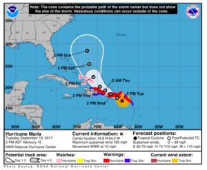
As of 2100Z today 19 September Hurricane Maria was located about 80 miles SE of the island of St. Croix and 175 miles SE of San Juan, Puerto Rico. The category 5 storm is slowly moving WNW at 10 mph. This movement and speed will place the cyclone right over the whole island of Puerto Rico by Wednesday 20 September at around 1800Z.
All Puerto Rican coastal areas are under hurricane warning and all airports in the island are expected to close at some point tomorrow. The East and North coasts of the Dominican Republic are expected to be hit by the storm in the early hours of Thursday 21 September; these coastal areas are also under hurricane warning mainly affecting Punta Cana (MDPC) and Puerto Plata (MDPP), which will most likely stop operations sometime tomorrow.
More on the topic:
- More: EU-LISA: The BizAv Guide
- More: Crisis in Iran: Elevated Airspace Risk
- More: Greece Winter Runway Closures
- More: South Africa Permits: Still a Mess
- More: Japan BizAv Ops: Haneda, Narita, and Nagoya Explained
More reading:
- Latest: EU-LISA: The BizAv Guide
- Latest: Crisis in Iran: Elevated Airspace Risk
- Latest: Greece Winter Runway Closures
- Safe Airspace: Risk Database
- Weekly Ops Bulletin: Subscribe
- Membership plans: Why join OPSGROUP?








 Get the famous weekly