Update – Thursday Sep 28
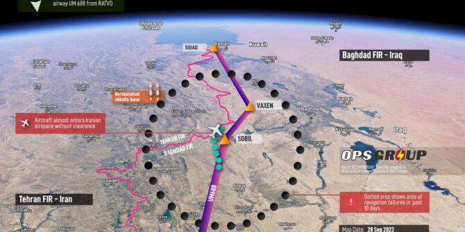
Since publishing Monday’s risk warning on complex navigation failures following fake GPS signals, we have received further concerning reports from operators, mirroring the same events. The impact of the nav failures is becoming clearer, with one operator almost entering Iranian airspace without clearance, and another left requiring ATC vectors all the way to their destination in Doha.
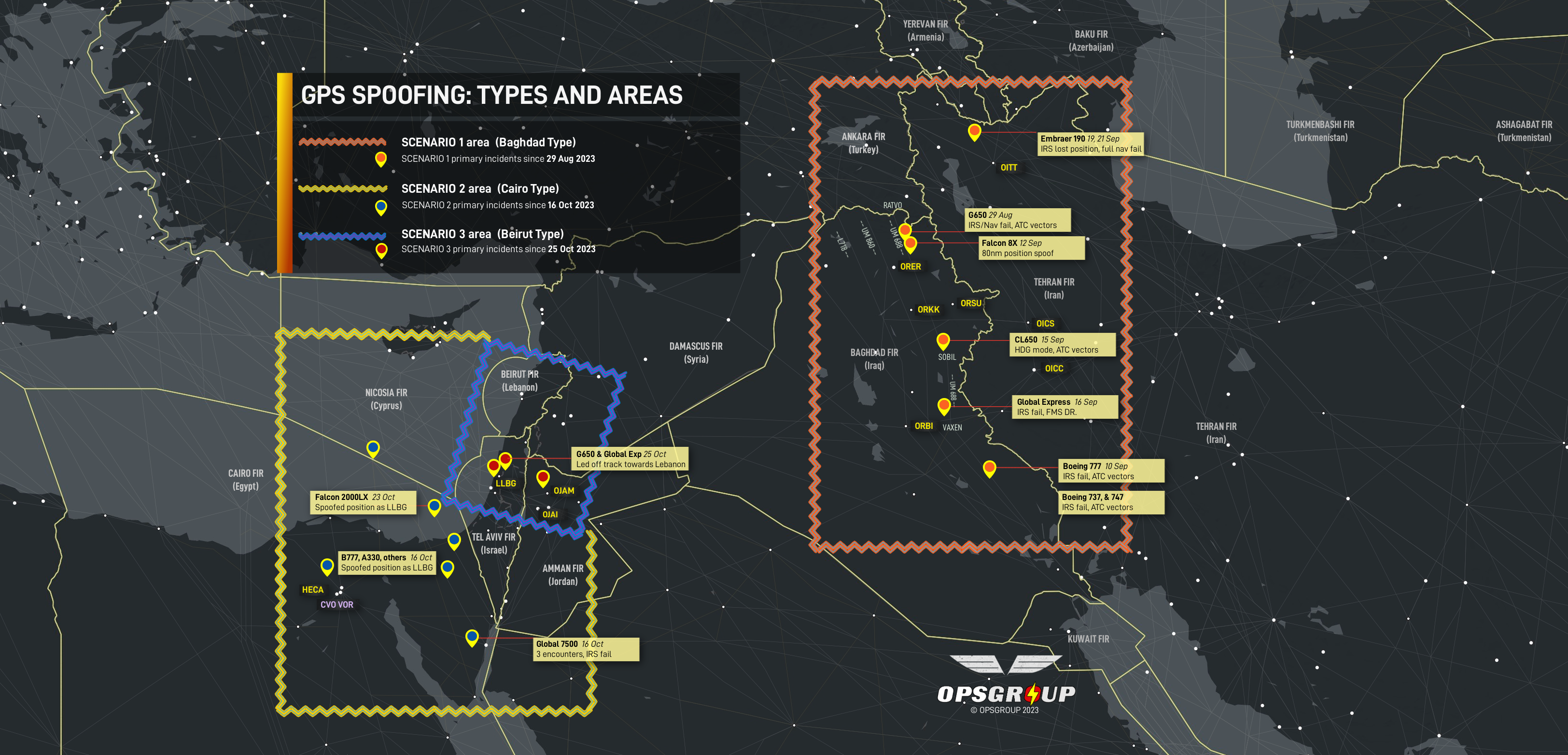
In total we now have 20 reports of almost identical situations. Full reports are in Version 2 of our Risk Warning (PDF).
On Wednesday evening, the FAA issued a warning memo to aircraft operators as a result of the situation, warning of increased “safety of flight risk to civil aviation operations”.
See new Briefing (28SEP) – “FAA Warning Issued, Further Serious Navigation Failures Reported”
Original article follows:
Key points
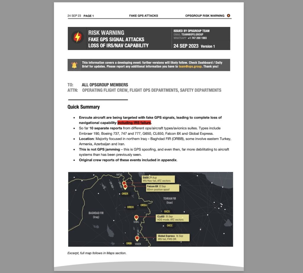
- New RISK WARNING: Enroute aircraft are being targeted with fake GPS signals, leading to complete nav failures
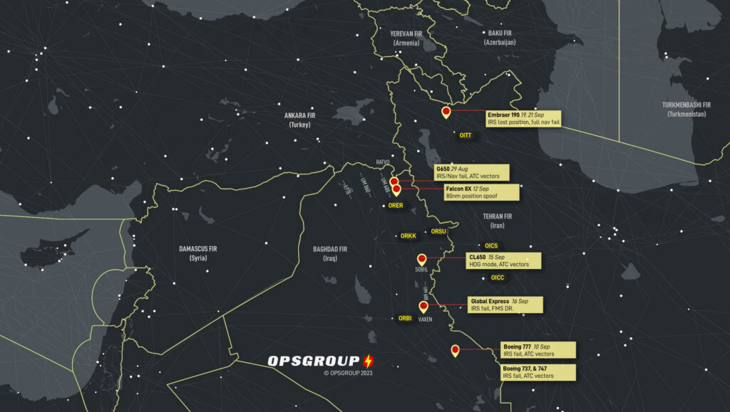
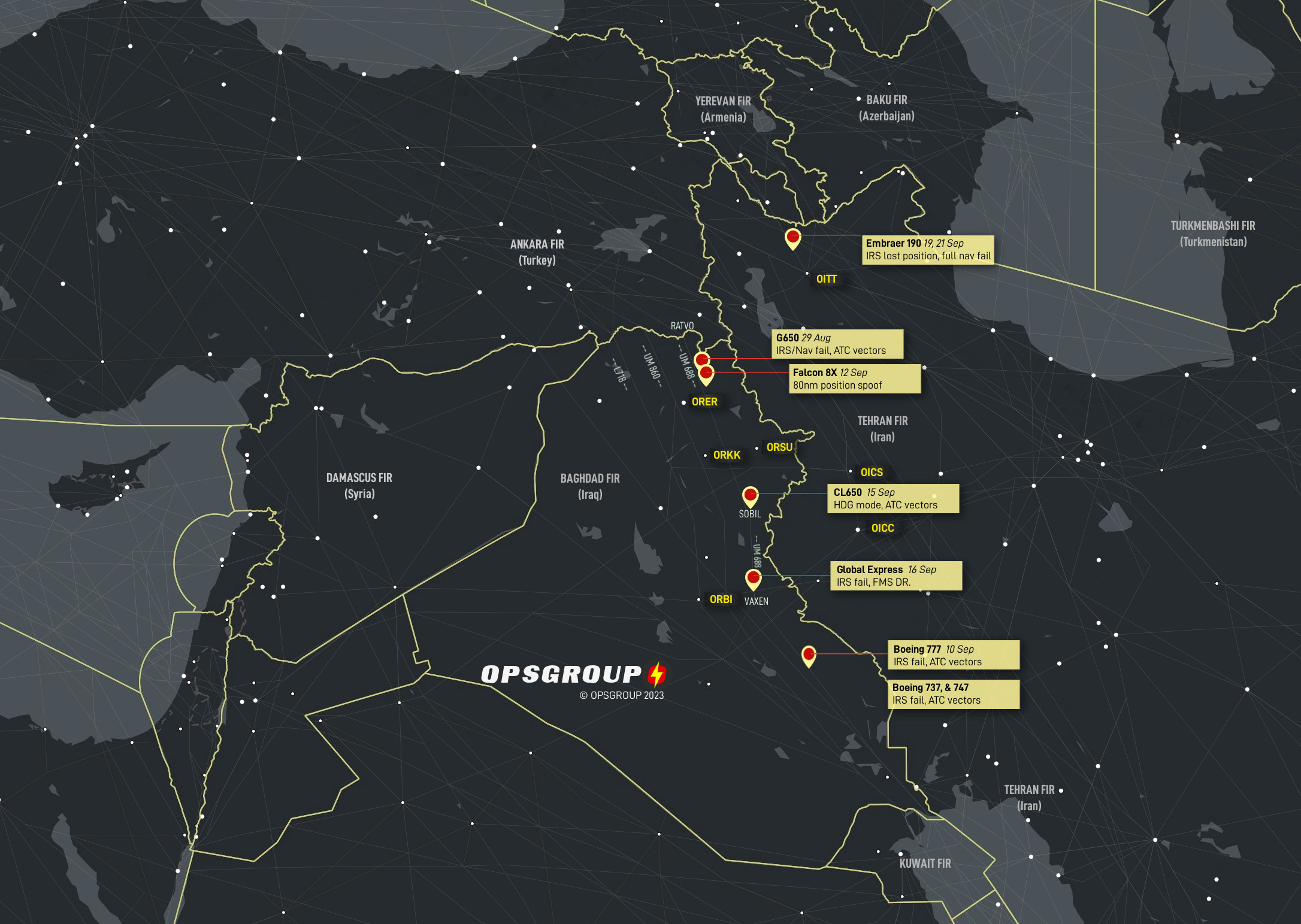
12 16 separate reports – types include Embraer 190, 600, Boeing 737, 747 and 777, G650, CL605, CL650, Lear 45, Falcon 8X and Global Express.- This type of GPS spoofing has not been seen before – IRS is quickly “infected” by false position
- OPSGROUP Members: Suggested Guidance and Procedures, and original crew reports, in Briefing PDF below

Situation
A troubling new development in enroute airspace is emerging: aircraft are being targeted with fake GPS signals, quickly leading to complete loss of navigational capability. 12 separate reports have been now received by OPSGROUP, and in most cases the IRS becomes unusable, VOR/DME sensor inputs fail, the aircraft UTC clock fails, and the crew have been forced to request vectors from ATC to navigate.
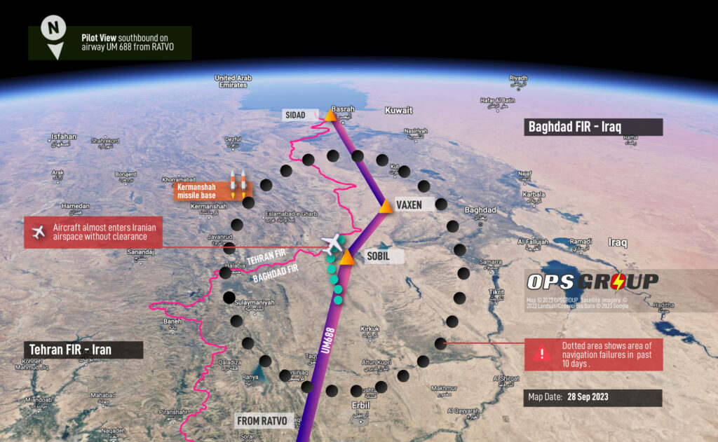
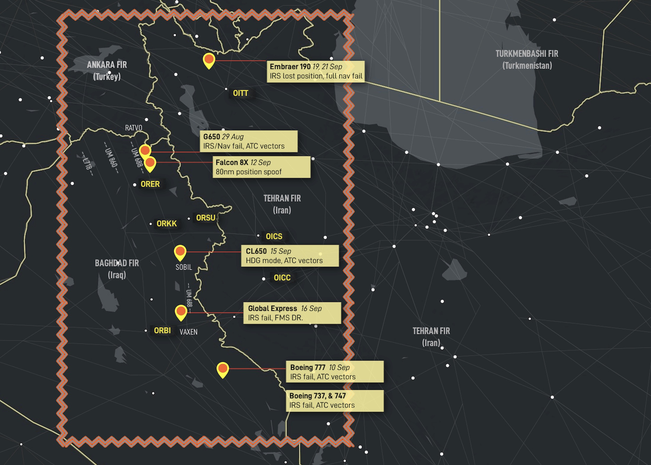
Most reports have been in the last 7 days. Aircraft involved include various Boeing types (B777, B747, B737), Embraer (190, 600), Gulfstream 650, Challenger 650, Global Express, and a Falcon 8X. The location for the majority is also quite specific: Airway UM688 in Iraq, close to the Iranian border.
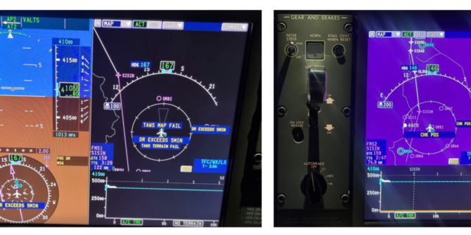
This immediately sounds unthinkable. The IRS (Inertial Reference System) should be a standalone system, unable to be spoofed. The idea that we could loose all onboard nav capablity, and have to ask ATC for our position and request a heading, makes little sense at first glance – especially for state of the art aircraft with the latest avionics. However, multiple reports confirm that this has happened. The key issue appears to be the way the IRS uses GPS updates to update its position during flight. Analysis from other OPSGROUP members is contained in the Briefing (Risk Warning) below.
In the Baghdad FIR, the crew of a 777 enroute were essentially forced to ask “What time is it, and where are we? “. Almost all incidents we’ve seen result in requiring ATC vectors to navigate. Clearly, in the areas that these events are occuring, this is disconcerting.
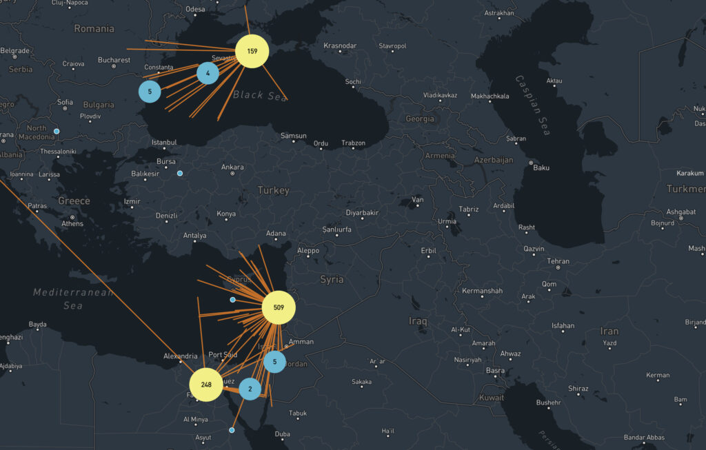
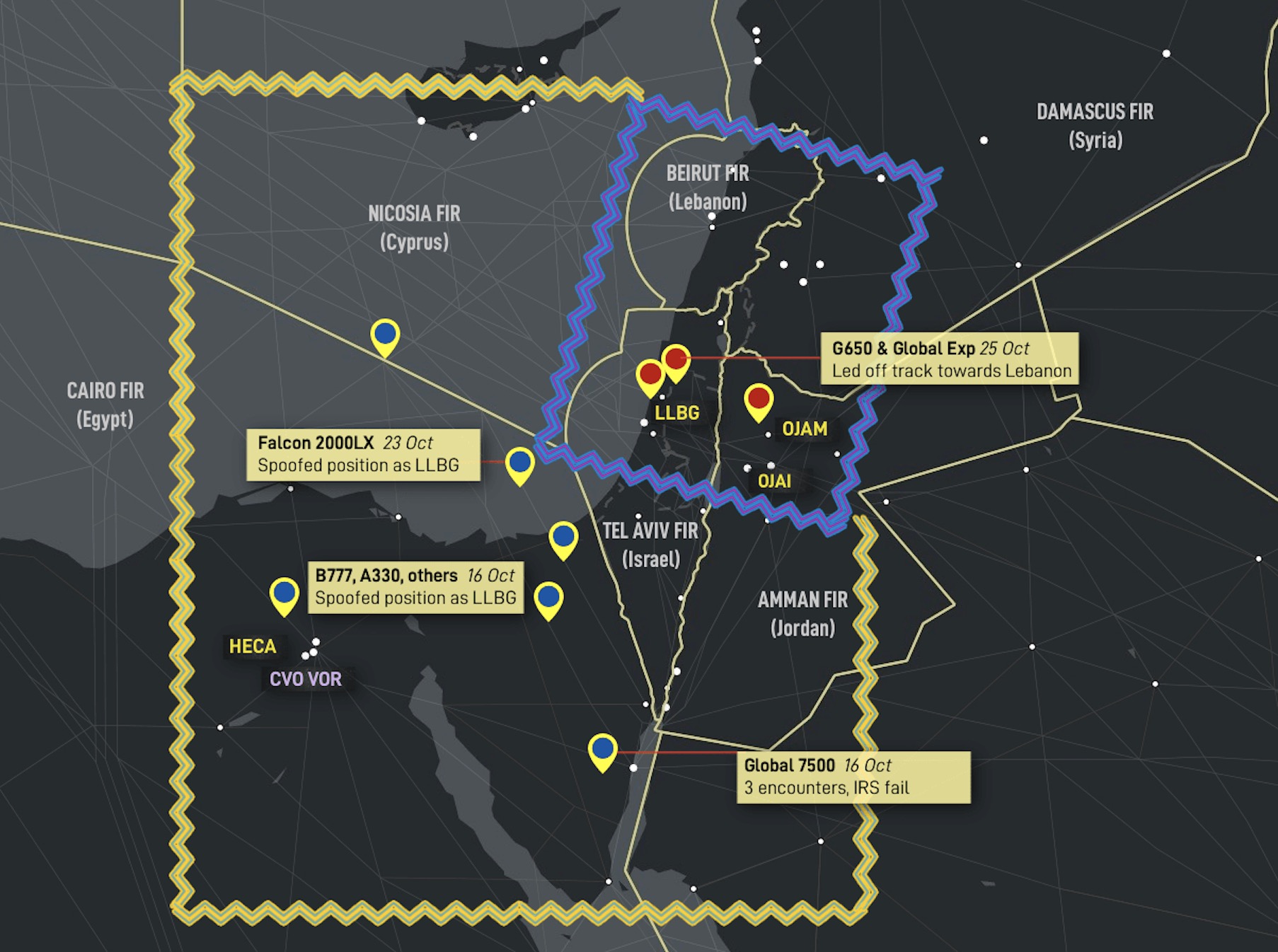
The location of reports received is mapped out below. The primary area of concern at the moment is Airway UM688 in northern Iraq. Most crews have reported the nav failures in the vicinity of ORER/Erbil, ORSU/Sulaimaniyah, and ORBI/Baghdad.
Full hi-res map available here
It’s important to highlight is that this not traditional GPS jamming – which we all experience almost as routine in these areas. We have become very used to GPS dropping out in Turkish and Iraqi airspace. These recent reports are GPS spoofing – and even then, not like anything we’ve seen before.
In most reports received, the situation plays out the same. A spoofed GPS signal is directed at the aircraft, or at least, received by the aircraft. The GPS position shifts by 60nm. The onboard systems start to react. Some crews have been able to quickly disable GPS inputs, but for the majority, the spoofed signal quickly leads to a nav failure.
One of the crew reports for an Embraer 190 (see below), tells us, “I have been on the aircraft for 13 years. I tried everything I know, but nothing helped. Two IRS’s, which are updated from GPS, lost position. FMS disagree messages appeared. The main point is to disable GPS inputs at the very beginning of spoofing. If you miss a moment, you will lose navigation capability!” This crew member is also Technical Pilot for the E190 type.
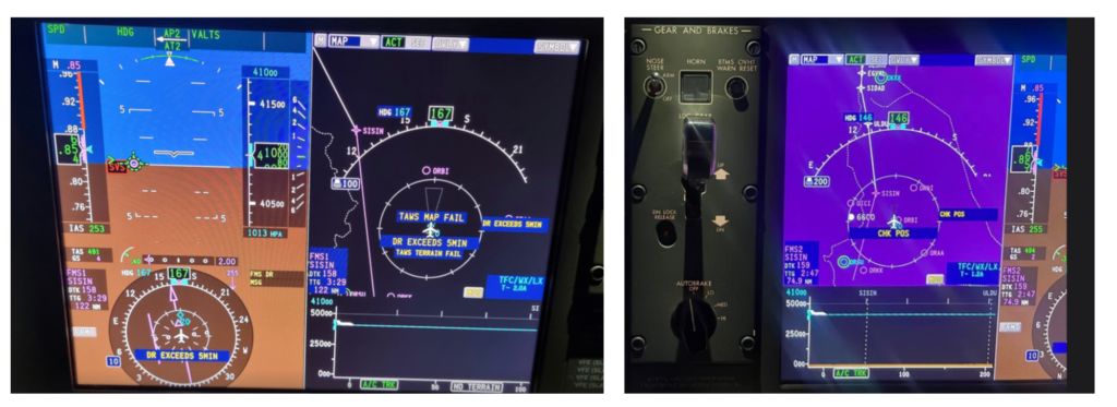
Aircraft position shown over Baghdad, but true location is 60nm east of that.
Worrying scenario
Of all locations that we fly through, the one place we don’t want to have any navigation issues would be along UM688. This airway runs southbound through Iraq, above an active conflict zone, and extremely close to the border with Iran. Any indavertent straying into Iranian airspace without a flight plan risks action by the Iranian military.
And yet it is precisely here that most of these events in the last week have been happening. As such, the risk to routine flight operations is extremely elevated.
OPSGROUP recommends that all operators using airway UM688, or entering the Iraq/Iran/Turkey region, review this new risk as soon as possible. Flight Crew should be made aware of the potential for fake GPS signals, the likely impact on aircraft systems, and a plan of action should this occur.
OPSGROUP Member resources
Over this past weekend (23-24 September), OPSGROUP members provided analysis of the events, and recommended guidance. This work has been collated into Briefing: RISK WARNING 24SEP/V1, available to all members in your Dashboard. Direct links are below.
- Download Briefing: RISK WARNING – Fake GPS signal attacks (PDF, 0.7 Mb)
- Situation report
- Key information for Flight Crew
- Analysis from OPSGROUP members
- Original Crew reports of GPS spoofing/Nav & IRS failures (First 10 reports listed)
- Guidance and Procedures
- Awareness of risk locations
- Recommended Procedure – entering risk area
- Recommended Procedure – active GPS spoofing
IRS failures
An excerpt of analysis from the Briefing Document above helps us understand the issue better:
“Most avionics suites are now engineered such that the IRS position is regularly GPS updated to ensure the highest accuracy, if the GPS fails!
Therefore if the GPS is jammed, then the IRS works from its last known position. However if it receives a spoof position, the system still believes the GPS input received to be accurate as all sources “say” the same thing, and this spoof position is then updated to the IRS(s) to match. Most avionics system know that a shift/gross-error has happened as ground based updates do not compute the correct position, and will flag a navigation/map/position warning.
However, all primary navigation systems end up being corrupted as a result. It has the potential to be very dangerous, and is part of the reason why pilots should back up navigation still, with “green needles” / ground based aids wherever possible. Our dependance on GPS is not always good!
I would recommend using conventional ground based navaids (DME/VOR/NDB) as far as practical, otherwise request assistance from ATC. Some platforms may allow IRS systems to be disconnected from GPS auto-updating, but most now do it in the background with no optional pilot interaction.
Unless the IRS systems are completely independent (the old fashioned ones that have to be initialised at startup location), GPS integration for frequent position updates, is sadly the issue due to its vulnerability to spoofing. For those that can disable the updating, they may wish to consider turning this function off, however it may impact on navigation capability, AFM requirements and operational approvals.
I would recommend that pilots and operators reach out to their OEMs for their recommendations on dealing with spoofing on their platform.”
Another member (767 operator) spoke to an IRS expert for perspective – also arguing that “the IRS system is “stand alone” and the only mixing between GPS and Inertial is inside the FMS and thus, the IRS couldn’t be spoofed. He assured me it could. Not enough to lose the alignment platform, but enough to confuse the present position and thus, none of the radio navaids are where they’re supposed to be.”
Updates
This information covers a developing event: further versions will likely follow. Check your members Dashboard / Daily Brief for updates.
Much of the information is compiled from member feedback. If you have any expertise to share, or information to add – please email team@ops.group, or send a WhatsApp message to +1 747 200 1993.
Thank you!


