NAT Conundrums Volume IV: Contingency Procedures

Welcome to our 4th Volume of North Atlantic Conundrums!
Volume I covered the following three conundrums:
1. To SLOP, or not to SLOP?
2. What’s the difference between the NAT Region and the NAT HLA?
3. Can I fly across the North Atlantic without Datalink?
Volume II covered these additional three:
4. Do you need to plot on Blue Spruce Routes?
5. Do we still fly Weather Contingency Procedures on Blue Spruce routes?
6. When can we disregard an ATC clearance and follow the contingency procedure instead?
Volume III looked at:
7. GOTA airspace.
And this post, Volume IV, looks at NAT Contingency Procedures – not those related to weather issues (which are well-known and described in the regs without the risk of misinterpretation), but those related to times when you need to deviate from your ATC clearance (due to comms issues, turbulence, depressurization, engine failure, immediate diversion, and other emergency situations).
What are in-flight contingency procedures on the NAT, and which regulation governs them?
These are established to address situations where aircraft may encounter difficulties or emergencies while operating in the NAT airspace. They are primarily governed by the ICAO Document 4444, which outlines regulations for air traffic management practices and procedures. In this article, we will focus specifically on non-weather related contingency procedures.
I’ve heard of the NAT Doc 007. Is it the main reference for NAT contingency procedures?
Yes and no. While the NAT Doc 007 is a valuable resource for operators in the North Atlantic region, it’s important to note that it explicitly states, “this document is for guidance only.” The primary regulatory framework for contingency procedures in the NAT remains ICAO DOC 4444.
Do I need a clearance to continue my flight?
Yes, you typically need a clearance to continue your flight. If an aircraft is unable to continue the flight in accordance with its ATC clearance, a revised clearance shall be obtained, whenever possible, prior to initiating any action.
Are there situations where I may not have a clearance?
There may be exceptional circumstances (such as emergencies or comms difficulties) where obtaining a clearance becomes challenging. In such cases, pilots should prioritize safety and follow established contingency procedures to ensure safe flight operations while seeking to obtain a revised clearance as soon as possible.
If I have already reported a contingency situation and subsequently receive a clearance, should I always follow the new clearance?
Yes, if you have been issued a clearance, you should adhere to it as long as it is safe to do so. If the new clearance is not safe, request an alternative clearance from ATC. Safety should always be the top priority.
If I have not yet been able to obtain a clearance, what should I do?
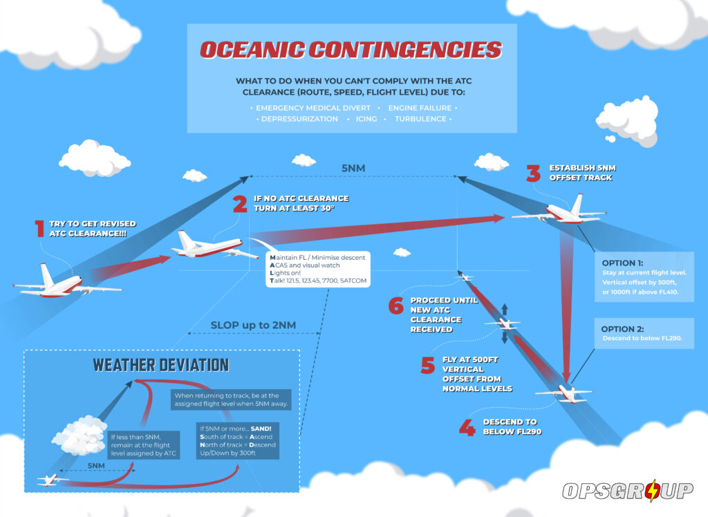
The procedure changed on the NAT in 2019, and then became the global standard in 2020 – so there is now one standard set of Contingency Procedures for all oceanic airspace worldwide (well, almost all airspace – there are still a few places which have slight differences, although these will eventually get aligned):
Leave your cleared track or ATS route by initiating a turn of at least 30 degrees to the right or left, in order to establish and maintain a parallel, same-direction track or ATS route offset of 5 NM.
Once established on a parallel, same-direction track or ATS route offset by 5.0 NM, you have two options:
- Establish a 500 ft vertical offset (or 1000 ft if above FL 410) from the usual flight levels, and proceed as required by the operational situation, or if an ATC clearance has been obtained, in accordance with the clearance.
- Descend below FL 290, and establish a 500 ft vertical offset from those flight levels normally used, and proceed as required by the operational situation or if an ATC clearance has been obtained, in accordance with the clearance.
The first rule is straightforward, involving manoeuvring to navigate between significant traffic operating in the North Atlantic High-Level Airspace (NAT HLA) by adjusting altitude with a 500 or 1000 feet offset before making a turn. However, the second rule, when maintaining altitude is not feasible, can sometimes be misinterpreted.
Why is the rule of descending below FL290 sometimes misunderstood?
The current wording of ICAO Doc 4444 can sometimes lead to confusion, as it may imply that aircraft must first descend to establish a 500 ft vertical offset before making any lateral deviation. This is not the intended interpretation.
This misinterpretation was perpetuated by the 2023 version of the NAT Doc 007 (version 2023-1), which said: “descend below FL 290, and establish a 150 m (500 ft) vertical offset from those flight levels normally used, then proceed…”. This wording inadvertently supported the misconception by introducing the word “then” implying a strict sequence in the procedure.
The new 2024 version of the NAT Doc 007 (version 2024-1), which becomes applicable in March 2024, has been corrected, replacing the word “then” with “and”, in line with ICAO Doc 4444.
How should it be understood?
The purpose of updating the contingency procedures in Doc 4444 was notably to provide a clear and effective way for aircraft to safely navigate and disengage from OTS (Organized Track System) with adjacent and nearby PBCS tracks without the risk of collisions. This is achieved by offering two primary options:
- Using vertical offsets; or
- In cases where maintaining altitude becomes impractical and to mitigate the risk of conflicts with the majority of traffic, which is located within the NAT HLA, descending below FL 290 before diverging.
As a result, depending on the situation, lateral divergence can be initiated as soon as FL 290 is crossed during descent, without the prior obligation to establish first at a potentially low FL offset before proceeding with the divergence.
In cases of depressurization requiring a descent to lower levels, or an engine failure necessitating a descent to lower levels depending on ETOPS speed, it may be preferable to initiate the turn as soon as the aircraft passes FL 290 when the alternate airport is located behind. This helps save valuable time, approximately 10 minutes, in returning to the same point as when crossing FL 290, especially in emergency situations.
In other circumstances (like when the alternate airport is located ahead), a pilot may elect to establish the vertical offset first.
The Doc 4444 regulations allow for both of these courses of action. Moreover, it’s worth noting that the fuel planning for critical ETOPS scenarios typically does not account for continuing for a long time in the wrong direction before initiating divergence.
How do I know that this is the correct interpretation?
Because we asked ICAO.
They told us that after reviewing all the working papers, it’s clear that the intent is focused on getting below FL290 before doing anything (if possible).
We also received confirmation that the SASP secretary, the ATM ops panel secretary, and the Flight Ops panel secretary had all discussed the issue and had agreed that the interpretation provided was correct. This does not reflect a specific panel viewpoint but rather a consolidated ICAO Secretariat view of the interpretation.
While it is preferable, given favorable conditions, to be at the offset level before initiating a turn (as this minimizes the potential for conflicts with other aircraft operating on adjacent tracks, providing some vertical ‘separation’ before turning across parallel tracks), the primary emphasis remains on descending below FL290. This priority is clarified in Doc 4444 Note 2 to 15.2.3.2(a) :
“Note 2.— Descent below FL 290 is considered particularly applicable to operations where there is a predominant traffic flow (e.g. east-west) or parallel track system where the aircraft’s diversion path will likely cross adjacent tracks or ATS routes. A descent below FL 290 can decrease the likelihood of conflict with other aircraft, ACAS RA events and delays in obtaining a revised ATC clearance.”
Ultimately, in emergency situations where it becomes absolutely necessary to deviate from the rules, it’s down to the pilot-in-command to assess the validity of an immediate diversion in consideration of the risk of conflict with nearby aircraft in the high-level oceanic airspace. As ICAO Annex 2 says:
“The pilot-in-command of an aircraft shall have final authority as to the disposition of the aircraft while in command… the pilot-in-command may depart from these rules in circumstances that render such departure absolutely necessary in the interests of safety.”
Key takeaways
In non-weather contingency scenarios, once you’re established on a parallel, same direction track or ATS route, offset by 5 NM, there are two cases to consider:
- If you can maintain altitude, adjust your altitude by 500 or 1000 feet and then make a lateral turn to insert yourself between the traffic in the NAT-HLA.
- If maintaining altitude is not possible, descend below FL290 while continuing your descent toward a 500 feet offset, allowing you to diverge beneath the traffic in the NAT HLA.
In cases where maintaining altitude is not feasible, there is no obligation to first establish an offset level before initiating divergence once FL 290 has been crossed during descent.
With any luck, future versions of Doc 4444 will make all of this more explicit, in order to avoid various misinterpretations!


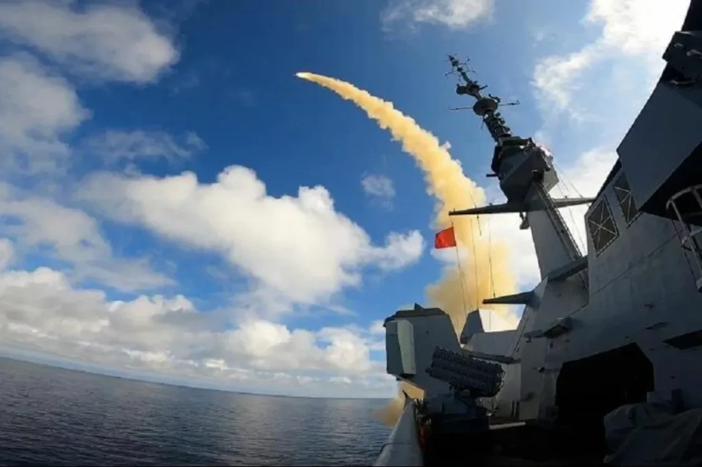
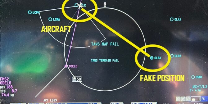
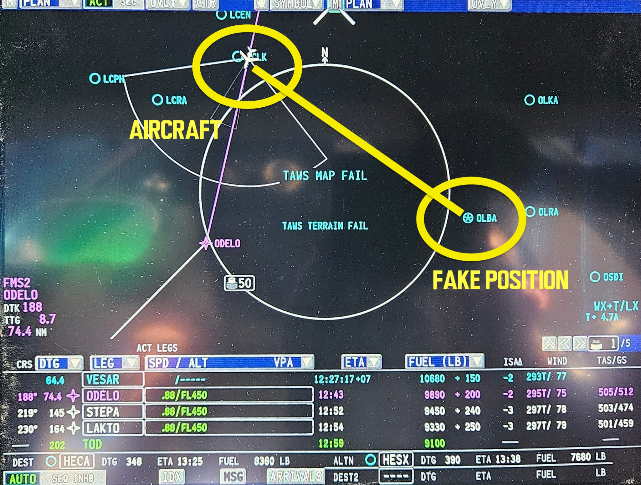
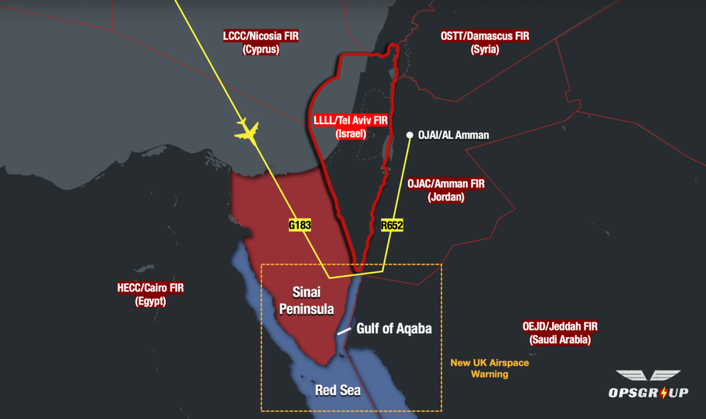 The primary risks to overflights are from misidentification or mis-targeting. The military air defence equipment present is advanced, and capable of reaching all levels.
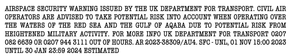


 …although the last one is still recommended by the FAA.


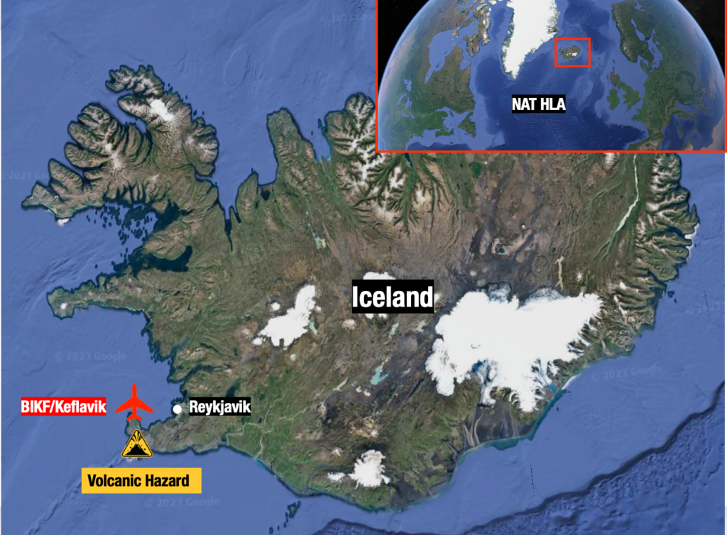
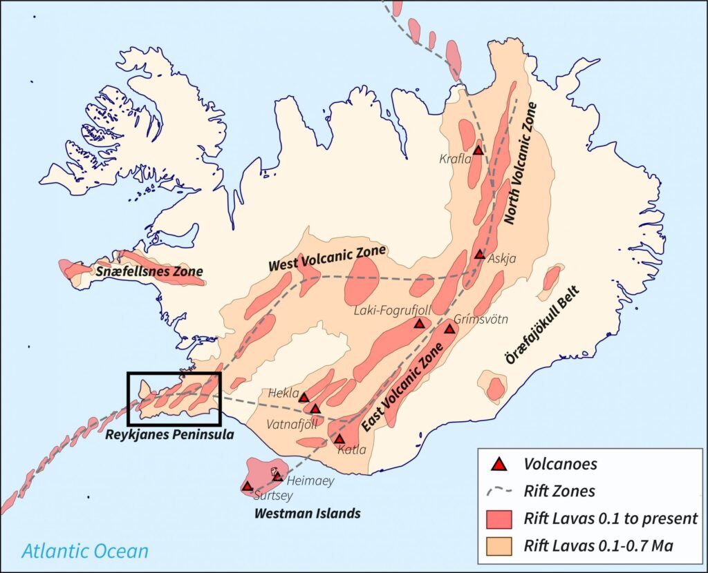
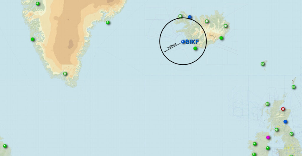


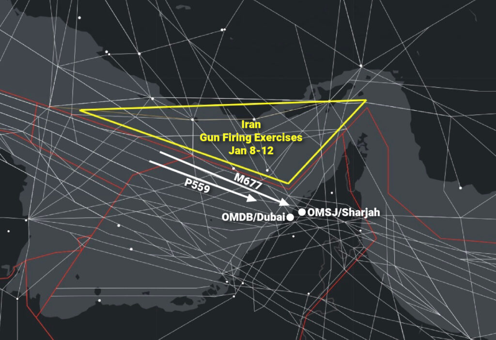
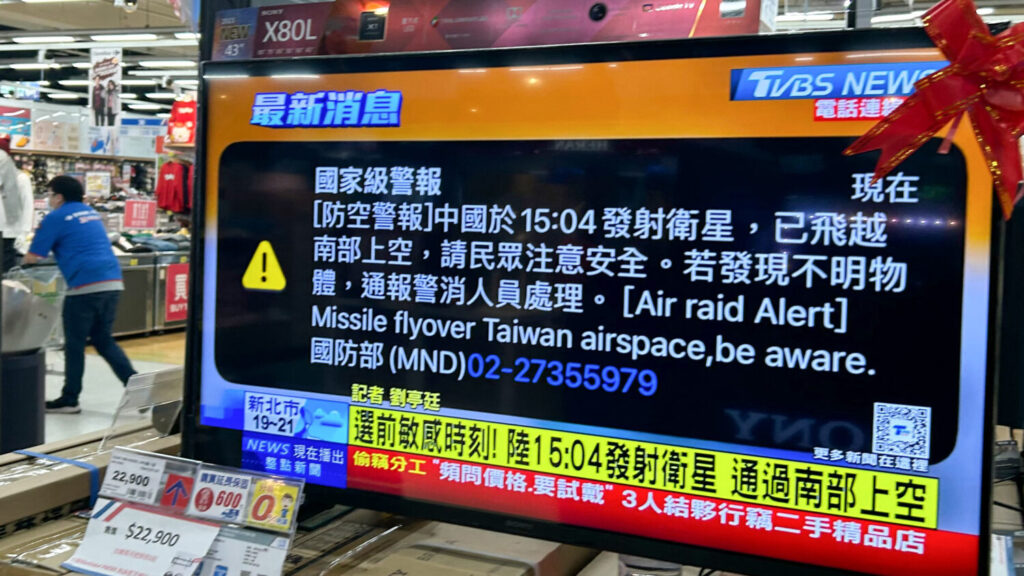
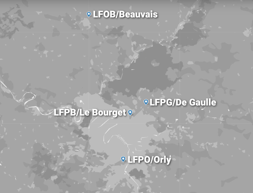
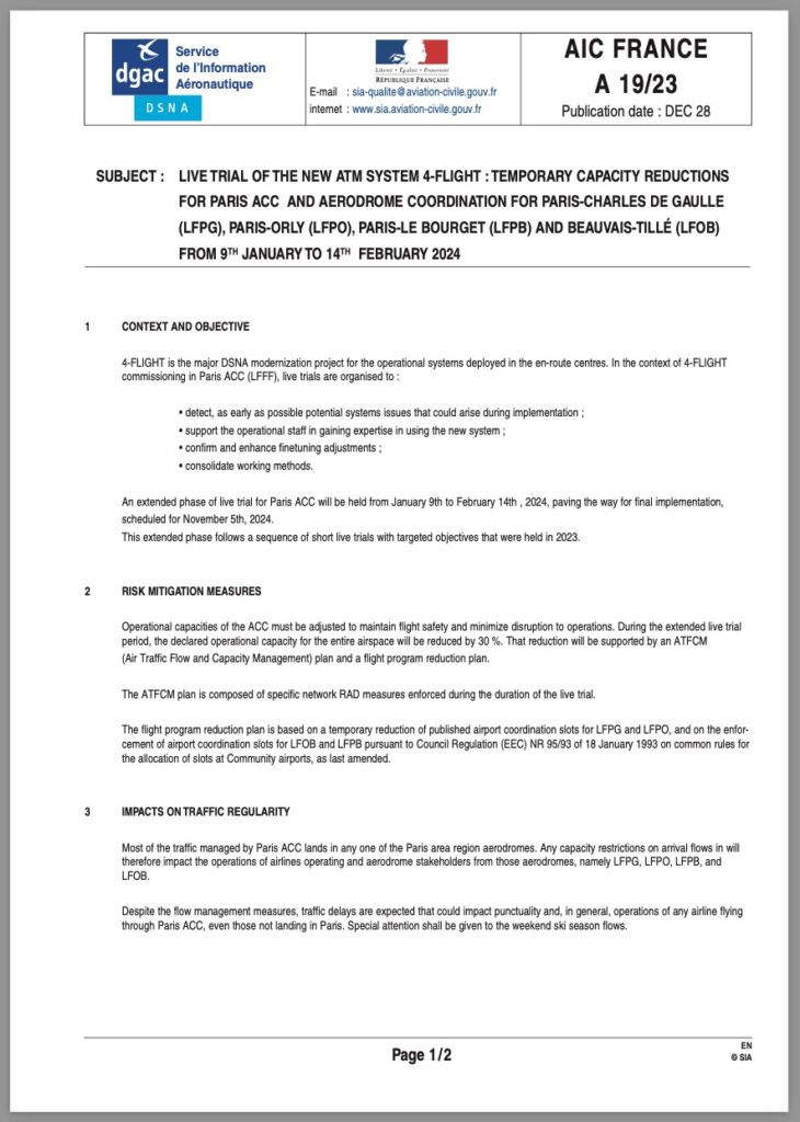
 All traffic crossing the NAT or operating over Western Europe right now should be keeping a close eye on this one.


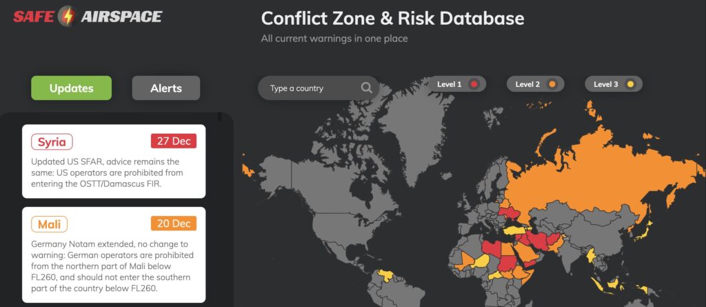
 Airspace warnings aren’t new for the


 1030 every morning


