Alphabet Soup: FAA New Flight Planning Codes

The FAA are changing up some flight planning codes, and they’ve published their plans in a handy little guide entitled ‘Filing for advanced capabilities using the ICAO flight plan (FPL)’.

We thought we’d take a look at what these new things coming into the FAA flight plan filing code world might be. When we say take a look, we mean literally type up the presentation and add some thoughts of your own.

This just applies to FAA flight plans, right?

Yes. No. Maybe…

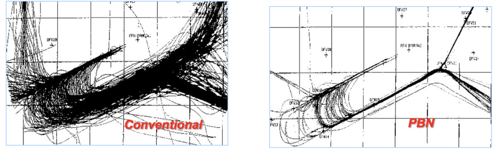
We think it is a yes because the US is implementing a lot of RNP1 SIDs and STARs (basically stuff that requires advanced Nav capabilities) and for reasons we’ll mention below, they need new codes.

You can expect to see a load of new items which relate to NAV/ and also DAT/, SUR/ and COM/. ICAO has “frozen” Items 10 and 18 for PBN/ unless it is a safety critical thing.

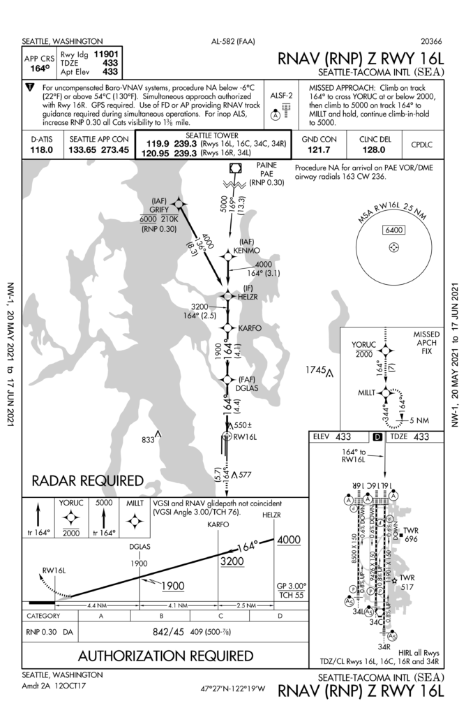
What’s more, in the FAA presentation there is a lot of talk about the STAYY SID into KSNA/Orange County (guessing because it will be the first RNP 1 SID published?). So, from Septemberish to Novemberish, if you’re flying there and are planning on flying this approach then you’ll need to be filing these.

So it’s all about RNP1?

Mostly, yes. RNP 1 SIDs and STARs require Radius to Fix (RF) capability. There is some mention of RNP2, which is used in the UK and Australia. The FAA are working with them to clarify this because there are actually two different RNP2 standards so it is currently a bit ambiguous.

What are these codes?

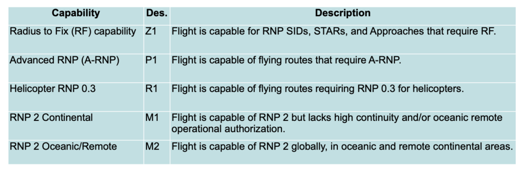
We are seeing a ‘Z’ which will go into Item 10a and a Z1 which will go into NAV/

What else?

Here is a table. Lots of new letters with a 1 after them (or a 2) confirming your various RNP capabilities.

What do we use at the moment?

Let’s take a quick jump back and talk about ‘Relevant Flight Plan Fields’.

If you’ve ever filed a flight plan, you are probably fairly familiar with Item 10 – Equipment and Capability (with 10a for your Nav, Comms and Approach Aids and 10b for your Surveillence). Then there is Item 18 – Other Information, and this is where you enter your PBN, NAV, DAT, SUR and COM stuff.

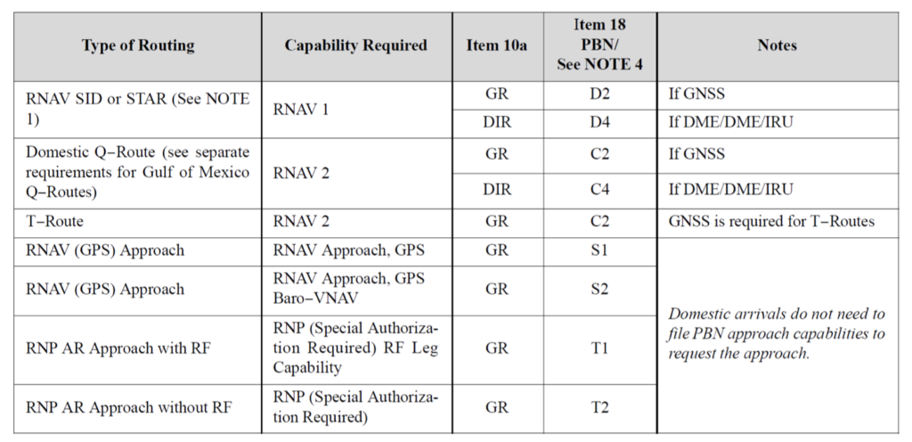
So, depending on the type of routing or what-have-you that you plan on doing, you need to add info in item 10 and item 18 to confirm you’re capable of doing it.

Here is a handy table for you. Basically, if the plan is to fly a ’T-Route’ for example, then your airplane needs to be capable of RNAV 2, which means you’ll want to whack a ‘GR’ into Item 10a and a ‘C2’ into Item 18.

Current AIM instructions

GR of course means GNSS and R means PBN approved. C2 means RNAV 2 GNSS specifications.

If any of this is totally new to you…

Maybe take a read of FAA Appendix A. FAA Form 7233-4 ‘International Flight Plan’ which covers all the boxes and their respective what’s and why’s.

PBN/ is limited.

Something else mentioned in the presentation is the limited number of PBN/ entries that you can make on your flight plan. This limit means the automation which “reads” your plan might make some assumptions. For example, if you enter a D1, D2, D4, O1 or O2 code, it is going to assume you are RNAV 2 capable.

There are also certain PBN/descriptions which don’t align with any OpSpec authorisations.

C3, D3, O3 – DME/DME is not adequate for RNAV 2, RNAV 1, RNP 1 and O4– DME/DME/IRU alone is not adequate for RNP 1.

All of which means changes are needed!

A reminder on using NAV/RNV to suppress a PBN segment

The automation (and this is a direct quote from the presentation) ‘bases route eligibility on PBN information but overrides that with the NAV/ information when provided’.

Right now, putting RNV means RNAV, so if you file NAV/RNV the automation won’t think you’re eligible for an RNP routing. In fact, 50% of flight plans which include RNP1 capability are only seen as RNAV 1 eligible. If this has happened to you, stop putting RNV in the NAV/ string.

The main point here is that the majority of users should be using PBN/ only.

There is more.

There is more, but it might be easier to read it in the FAA presentation itself. 

When all the FAA documents are changed and updated to include the new stuff, then this is what to look out for:

  • New NAV/ descriptors are coming in, including info on how to file them
  • Documentation on the new descriptors they’ve come up with will be there
  • Instructions on how to file RNP routes, including ones which require RF capability will be included
  • Instructions on how to use NAV/RNV to exclude PBN routes on a single segment will be removed (but there will be a web page and FAA contact info if you still need help).


The Gateway to the Skies

If you have not heard of the IFP Information Gateway then here is a little summary for you. It is the Instrument Flight Procedures Information Gateway which is, according to the FAA who run it, your centralized instrument flight procedure data portal.

It’s a handy site because it provides you with a single-source, one-stop-shop, first place to visit if you need info on any of the following:

  • Charts
  • The IFP Procedures plan
  • IFP Coordination (forms and things)
  • IFP Documents
  • IFP Request form – this is where you can submit a request or query on an IFP. SO if you fly somewhere and think an IFP needs creating, amending or cancelling, you can do it here!

And this isn’t just for US pilots – it is pretty handy for anyone flying into the US who flies IFR procedures.

The Optimisation Project

This is a major project that the FAA are undertaking. They are reviewing their entire inventory of equipment and procedures as part of a plan to modernize the National Airspace infrastructure – to improve airspace and airport efficiency and safety.

The NAS covers an area of something like 30 million square miles, so it is a big project.

What is the plan?

The introduction of PBN (performance based navigation) is a big part of the modernization. If you fly into the US then you need to know about this, because it is going to mean changes to routes and procedures, airspace and equipment required.

Charts are being updated to remove unnecessary clutter. In 2020 they cancelled 1,000 procedures and took out things like circling minima on charts that no longer needed it. You need to know about this because it will impact chart validity, and things like minimus are airports you might use.

As for the inventory check – they are reviewing all the procedures at airports and deciding which to keep, which to cease, and which just plain old need updating. This will start with the decommissioning of any ancient VORs and NDBs which no longer support the operations network. You need to know about this because there will be ongoing changes to the approaches available at airport.

Give us some more details on the inventory checks

The FAA are going to review all procedures.

Why?

Well, because having looked over some data they reckon at least 20% of current IFPs have pretty limited benefits to the NAS. If procedures are not being used then retiring them means lower admin, maintenance and training costs. It also means more efficient and effective airspace management, which means improved safety and access.

Take KSEA/Seattle for example. They have an RNAV RNP approach and a GPS approach for runway 16L. The RNAV RNP was only flown 17 out of a whopping 191,448 IFR arrivals.

It has higher minimum and an identical flight path to the GPS approach so there is really no reason for this approach to exist.

KPAE/Paine Field is another one worth looking at. It has a VOR-A approach which was only flown 95 times out of 10,348 IFR arrivals. It is under-utilized, costs a bunch to maintain and there are plenty other options. So it is a good one to chop.

What about KSBA/Santa Barbara airport and their VOR or GPS approach runway 25? This was also significantly under-utilized, being flown just 1,732 out of 17,174 arrivals. However, it is the most commonly used approach for GA traffic, and is the only one available when the wind is favoring that runway. Not such a good one to delete.

The IFP plan won’t just review data and statistics, it also engages with the folk using the IFPs to make sure changes are benefiting those it needs to benefit. Santa Barbara won’t lose the procedure just yet, although they might get itself a nice new space-based one out of this at some point.

Comments and feedback

If you fly into airports and have comments or feedback on IFPs then get in touch, either by filing in the form, or emailing at 9-AMC-Aerochart@faa.gov. This project is a long, ongoing one, but one that will benefit any operator who flies in or out of the US, and there are opportunities there to provide input.

Check out the info


PBN, RNP and what it all means

All across Europe, ‘Airspace Improvement Events’ are occurring. It sounds huge. We were expecting new regions, routes, maybe some special-filtered cleaner air being puffed out into it…

Alas, we read through all the Airspace Improvement Event notices, and from what we gather, it is part of a big, ongoing project to implement things like Free Route Airspace, more PBN routes, and to basically tidy up the airspace a little. This is not limited to just Europe though – the world is going PBN.

So, less an ‘Event’ and more a ‘Something’?

Everything is moving to Performance Based Navigation. It has something to do with being compliant with EC Regulation 2018/1048, but really just comes down to more efficient, better, safer, increased capacity airspace and approach benefits for everyone.

As simply as possible – VORs are out, Waypoints are in.

In a bit more detail – fixed ATS routes will continue to be implemented for better flow management and lateral separation, you’ll hear more about Free Route Space, and you’ll start seeing more RNP approaches popping up at airports.

So it is actually quite a big change, but one that will be slow to get implemented. Actually, most countries brought in things like RNAV5 routes and SIDs/STARs that use RNAV1 and GNSS instead of old-fashioned, Navaid-based manoeuvrings quite some time ago, so this isn’t something pilots will necessarily notice and there is no Big Date to look out for.

Except for one – December 1 2022 (but we will get to that later).

Why don’t we like conventional Navaids anymore?

Well, old Navaids need a lot of maintenance and they break a lot. Ok, not a lot, but they do potentially double the chance of some sort of issue for an airplane relying on them. Take your bog standard ILS for example – it has ground transmitters and aircraft receivers (and all the bits around them and in between then) and if any one of these conks out then you can’t fly the ILS (quite so well) anymore.

Your GPS approach on the other hand relies on the aircraft system only, which means less to go wrong.*

*Actually satellites can have issues too – GPS Jamming is a big problem and the plan to decommission Navaids is being delayed because of this.

So, what does this all actually mean, practically?

For operators, it doesn’t mean a whole lot. Most aircraft will have been operating to RNAV5 for a fair old while now, so the only noticeable change will probably some newly named waypoints, and some slightly more efficient routings.

You might need to pay a little more attention to any MELs that affect your performance capabilities, and be aware that approaches might no longer have conventional Navaids as backups in the future because a bunch of these are getting decommissioned.

But overall, it really means keeping an eye on them charts to see what’s happening where, and to make sure you pull the right plate out for your arrival.

PBN, Say Again?

So, PBN, again. And December 1 2022. What happens then?

ICAO has ordered all approach charts to reflect the new specifications by December 1, 2022.

What is changing?

All charts will say RNP APCH on them (or RNP AR APCH) instead of RNAV, RNP (GNSS) or whatever other random title they currently have. The chart should have the three lines of minima on it which you will need to know – your LNAV, LNAV/VNAV or your LPV.

Which country is winning the chart race?

ICAO post updates on the implementation which you can follow here, although they last updated it in 2017 so let’s hope it is looking a little better now.

All the R’s

In case you are still lost at RNP instead of RNAV, here is a quick recap on some terms for you:

  • GNSS is your Global Navigation Satellite System and it is a generic terms for all satellite navigation systems including GPS, Galileo, GLONASS, and ones augmented by ABAS, SBAS, GBAS… all the BASes.
  • LNAV, VNVAV, LPV, LP are your different minimus given on an RNP approach chart.
  • PBN is Performance Based Navigation based on performance requirements of the aircraft on a route or approach or in designated airspace.
  • RNP is required navigation performance which basically means the onboard monitoring and alerting system your aircraft has.
  • RNP Approach is a generic term for any approach which uses GNSS to enable it and an RNP system to fly it.
  • RNAV Approach is what RNP approaches used to be called.
  • RNP APCH is the name of the navigation specification in the ICAO PBN manual for the 4 types of approach:
    • LNAV (GPS NPA)
    • LP (SBAS-based NPA)
    • LNAV/VNAV (APV Baro-VNAV)
    • LPV (APV SBAS or SBAS Cat I)
  • RNP AR APCH is an approach the requires a specific aircraft qualification and operational approval. Usually because it takes places in an environment “rich in obstacles”. The AR stands for ‘approval required”. So you might be allowed to fly an RNP (RNAV) but not an RNP AR and your OpSpec (and training) are going to make this pretty clear.

What is Free Route Airspace?

FRA is a specified volume of airspace in which users can freely plan a route between defined entry and exit points. It makes the sector much more efficient.

And because we mentioned it earlier, what about RNAV?

Way back in the olden days (not as far back as when airplanes just had a compass and a map to use, but before GPS came in), there used to be Navaids. Ancient relics called VORs and NDBs which helped pilots work out where they were.

But then GPS came along and brought with it a way more effective and accurate way to navigate. How accurate is defined by ICAO under their four main navigation specifications – RNAV10, RNAV5, RNAV2 and RNAV1

RNAV5 is actually fairly basic. It has been around in Europe since 1998 and is mandated in pretty much all high level airspace there. 

The 5 bit refers to the requirement for aircraft to operate to a minimum navigational accuracy of +/-5nm for 95% of the time.

RNAV1 is your precision RNAV (1 being +/-1nm). RNAV10 is generally what you find over the oceans, and RNAV2 is generally used in en-route areas of the US.

Fun fact: The UAE and Bahrain FIRs implemented RNAV1 a while back, which means you need GPS Primary to route into here. If you’ve encountered GPS jamming en-route, (common in Turkey, Iran, Iraq etc, read all about that here), then this might cause problems for you.

What do you need for RNAV5 operations?

You need some sort of FMS, 1 IRS, 1 GPS or VOR/DME receiver and 2 nav displays.

What about RNP?

If it is an RNP navigation specification then there is also a requirement for on-board performance monitoring and alerting. RNAV refers to ‘area navigation’ and it is slightly different to an RNP system (the monitoring and alerting requirements). PBN requires an RNAV or RNP system, while and RNP APCH specifically requires an RNP system.

What else?

Actually, that’s about it. Except for the poor old UK that will no longer support LPV approaches from June.

Need to know more?

Here is ICAO EUR Doc 025 which contains all the EUR RNP APCH Guidance Material.


Australia: GPS requirements relaxed

The implementation day for Australia switching off Navaids remains the same: 26MAY2016, but the GPS requirements are relaxed – a little – especially for foreign private operators.

If you’re Australia based:

  • You’ll have seen this coming and will already be RNP1/2 compliant. CASA has no exceptions.


If you’re a Foreign Operator and have RNP1/2:

  • After 26MAY2016, if you’re RNP1/2 compliant, put it in the Flight Plan (read on), and that’s about it.


If you’re a Foreign Operator and you don’t have RNP1/2:

  • Australia has a Two Year Transition for Foreign Operators after 26MAY
  • An “Acceptable Means of Compliance” is contained in CASA EX06/16
  • Notify CASA in advance using Form “Notification to operate aircraft on RNP 2 routes and/or RNP 1 procedures using GNSS based RNAV 1 & RNAV 2”
  • If you are a non-commercial operator – ie. operating a Private flight, then compliance is not mandatory. According to CASA, through a release to IBAC, “Only commercial operators that can comply with the requirements and want RNP 1 and RNP 2 traffic services are required to apply for an exemption. “


Flight Planning:

  • If you have RNP2 – put GRZ in Field 10a and NAV/RNP2 in Field 18.
  • If you don’t, then you must operate according to Australia’s “Acceptable Means of Compliance” and put RMK/CASA RNP AMC in Field 18.
  • If you don’t, and you’re a private operator, probably worth a RMK/NEG RNP PVT FLT or similar.
  • Keep an eye on the charts – a bunch of new 5 letter waypoints are coming, to replace the VOR’s and NDB’s being switched off.

Reference:


Australia is turning off its Navaids – are you ready?

On the 26th of May, Australia will switch off around 180 different VOR’s, NDB’s, and other ground-based Navaids. Those that escape the cull – about 245 of them – will form the basis of their new “Backup Navigation Network”, or BNN.

For International Operators, in short, Australia wants you to navigate with GNSS as your primary means of navigation. The new standards, from 26MAY, are:

  • Oceanic Routes: RNP4 if able, otherwise RNP10
  • Continental Routes: RNP2
  • SIDs and STARs: RNP1
  • Non Precision approaches: RNP APCH (ie. RNAV(GNSS)

CASA will issue an exemption if you have an existing RNAV1 or RNAV2 approval based on GNSS from your National Authority, but you must have either the above RNP capabilities, or the exemption, to operate in Australian Airspace from 26MAY.

Further reading:


5618564-3x2-940x627