Last Line of Defence? Anti-missile Tech on Civilian Aircraft

According to an FAA document that’s hot off the press, back in 2019 a major US cargo carrier asked the FAA for the nod to install surface-to-air missile defence systems on some of its narrow body jet aircraft.

The FAA was left scratching its head – there were no rules in place to allow them to respond with a yay, or even a nay. It is almost un-chartered territory for commercial aviation. So much so that they’re asking the public for feedback.

But with surface-to-air weaponry a growing threat to aviation in conflict zones around the world, why is flying higher or avoiding them our only line of defence, when these counter-measures could be installed as our last? After all, they work for the military. Why not for us?

The answer may not be so simple. So let’s take a closer look.

What do we mean by counter-measures?

Simply put, technology designed to deter surface-to-air missiles. How they achieve this depends on how the missile is guided. While there are different ways, the two biggest threats to civil aircraft are from missiles that use radar or heat.

Radar

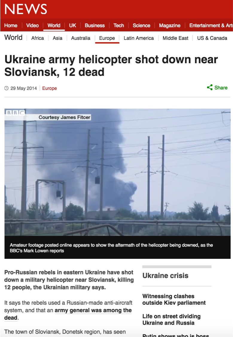
Radar guided missiles tend to be more advanced. Which is why airspace warnings found around the world refer to ‘advanced’ anti-aircraft weaponry – they can fly further and higher. They need fancy equipment on the ground, and trained operators to deploy or use them. MH17 was shot down by a radar guided ‘Buk’ missile in 2014 at FL330.

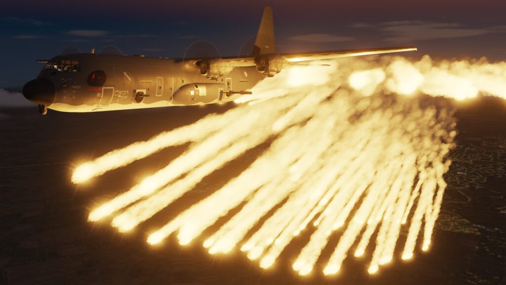
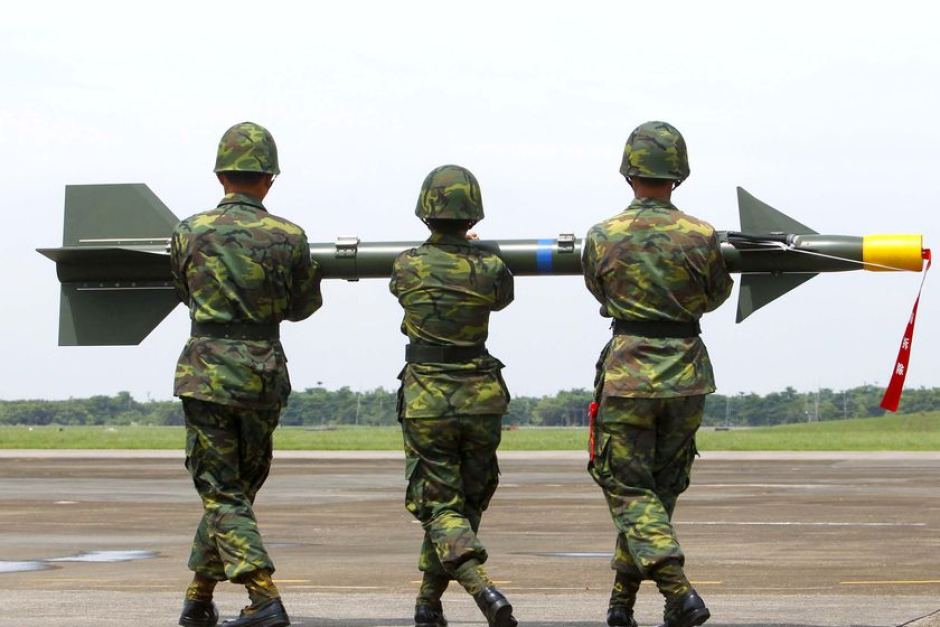
The military’s answer to this is Chaff. Or in other words, a cloud of small thin pieces of metal, metallized glass or plastic to bamboozle the radar with a cluster of targets. The Chaff is then generally lit up or ‘illuminated’ by a signal from the target aircraft so that the radar can’t distinguish between the two.

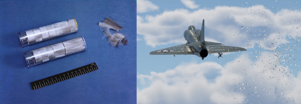
Chaff systems spread a cloud of small, thin pieces of radar reflective material.

Heat

 This is the biggest danger. Why? Because the majority of MANPADS use it. MANPADS stands for ‘man portable air defence system’. As the name implies, they’re light, self-guided and can be fired by a single person with little or no training.

What’s worse is that they’re scattered around the globe in the hands of non-state actors such as terrorist groups and can remain useable in storage for over twenty years. Which is why they’re so hard to control. In fact, over a million of them have been produced and now exist in over one hundred countries the world over. Since 73’ there have been sixty-five MANPAD attacks on civilian aircraft.

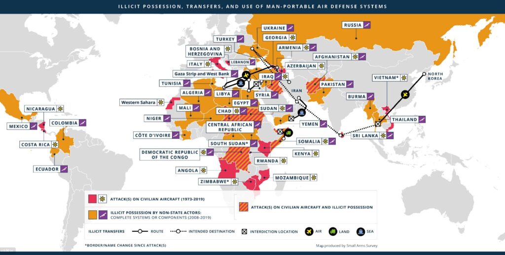
The possession of non-state actors with access to weapons such as MANPADS is cause for industry wide concern. Africa especially stands out. Courtesy: Small Arms Survey

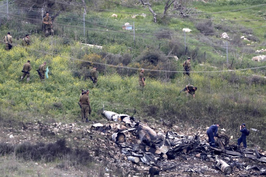
MANPADS generally can’t reach aircraft above FL250, and are short range – typically around 25nm. Which is why aircraft landing and departing are most at risk.

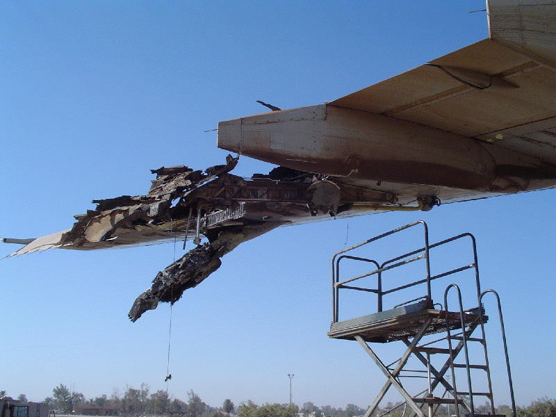
Aircraft are most at risk from MANPAD attack during take off and landing – like this A300 which took heavy damage to its wing departing Baghdad airport.

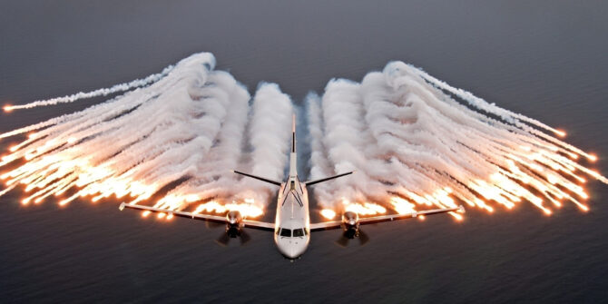
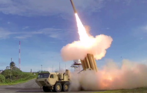
MANPAD missiles lock on to the heat an aircraft’s engines produce. Which is why they’re deterred with heat decoys. Military aircraft deploy flares – pyrotechnic devices that light up like fireworks. They burn magnesium which is far hotter than an engine’s exhaust.

Another method is the use of infrared. This is what our friends at the cargo airline are hoping to use. There are no fireworks with this device. Instead, it can detect an inbound missile and direct an infrared beam towards it to confuse its heat seeking abilities.

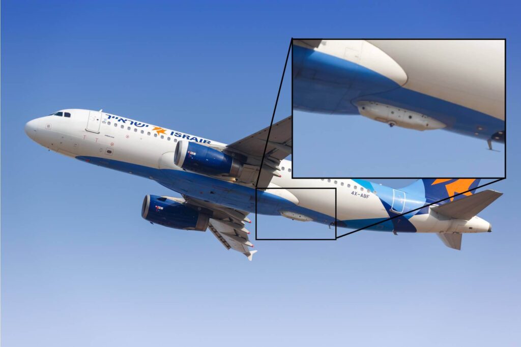
The recent application to the FAA was to install infrared pods like this one. The problem for the industry is cost.

Sounds great, sign me up.

The problem for civil aviation is that it is not the military.

For starters there’s the cost – which sadly is astronomical. That old chestnut. For instance, an infrared system like the one above would cost over a million USD to install – per airplane. This doesn’t include the extra cost of more weight and more drag.

Then there are the fireworks – chaff and flares. The military have specialists to install, service and store the equipment and the infrastructure to do it safely. And they are acutely aware of things that explode. Maintaining an industry-wide team of professionals who have the right training might be a step too far.

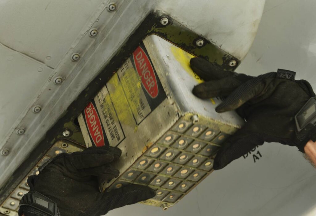
Large numbers of highly trained technicians would be needed for the industry to maintain flare and chaff systems.

But here’s what the FAA are most concerned about. What happens if these systems deploy at the wrong time or accidentally? Especially over built-up areas, on the ground at airports or onboard an aircraft itself. Magnesium, for example, burns at four thousand degrees fahrenheit and can’t be extinguished with water or halon. It’s dangerous stuff.

Magnesium flares burn extremely hot and cannot be put out with water or halon. Which is why accidental activations are a major concern on the ground, and aboard the aircraft.

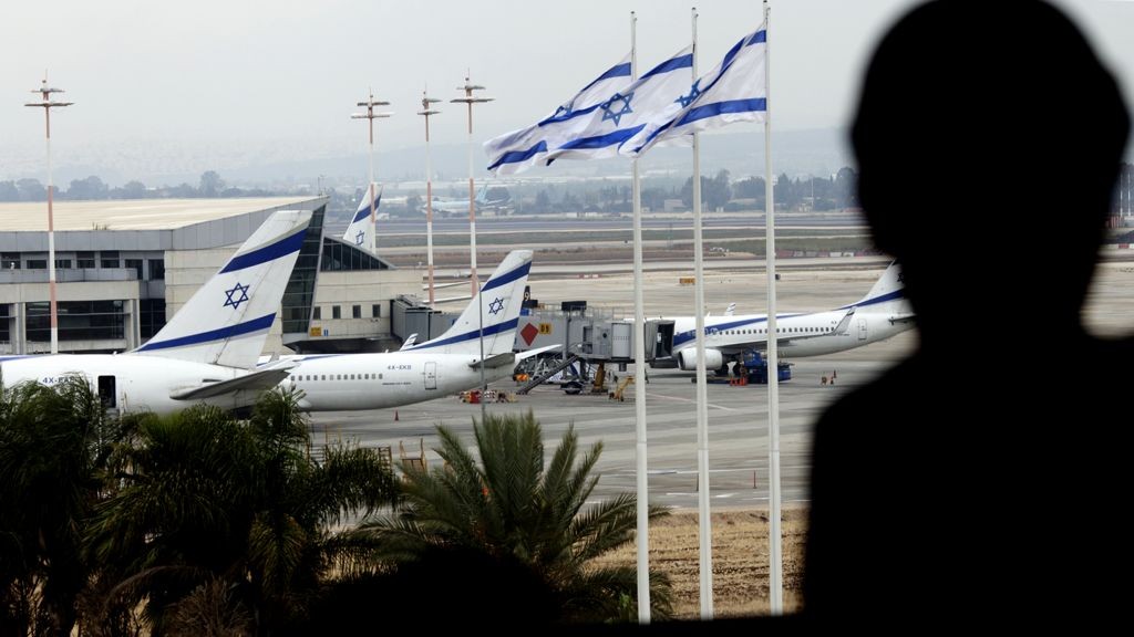
Israel’s carrier El Al has previously installed missile counter-measures on their aircraft which were banned from operating at some European airports.

All of these factors add up to risk and cost. And when measured against the actual risk of an aircraft being actively attacked by a surface-to-air missile, it may simply be cheaper to rely on existing measures. In other words, avoidance.

Finding the right fit.

This doesn’t mean all hope is lost. There is likely some type of future for military style counter-measures in civilian aircraft – for the right operation. Operators with small numbers of aircraft who regularly fly in high-risk airspace could immediately benefit from current tech, such as infrared systems without necessarily bankrupting themselves.

Or we can wait for the tech to become cheaper and more accessible. As is often the case, technology can develop from a military application into a civilian one. We just might not be ready for a straight swap just yet.

Back to the FAA.

It sounds like they think there is a future in it too. And work is underway to come up with a plan to approve applications for infra-red anti-missile systems on civil aircraft. This will include special safety conditions to mitigate some of the threats along with standard markings, training and other info to keep people interacting with these systems safe.

Want to contribute? You can read the FAA’s proposal here, and submit your comments. Just make sure you do it before March 4.


Why are we still flying airline passengers over war zones?

Here’s the level of inconsistency we’ve reached in international air transport: we take each passenger, scrutinize their booking, check the no-fly-list, watch them on CCTV, pull them apart at TSA, remove anything sharper than a pen, question them, x-ray the bags, run Explosive Trace Detection tests, screen the hold baggage, background check every member of the crew, and then, once they’ve all boarded, fly this ultra-secure airplane straight into a war zone.

Welcome to the Eastern Mediterranean. It’s an active conflict zone. The Russian naval build up there this month is the largest since Moscow’s intervention in Syria began in 2015. Over Syria, 9 aircraft have been shot down this year.

The most recent was on Monday night this week, when Syria came under attack from Israel fighter jets, and started firing indiscriminately at anything off the coast that looked like a threat. They wanted to shoot something down, and they did — except it was a friend, not foe. They took out a Russian Ilyushin IL-20M transport category airplane. Even on the worst radar, that doesn’t look anything like an Israeli F-16.

50 miles away from where the Russian aircraft plunged into the sea on Monday night is the international airway UL620, busy with all the big name airline traffic heading for Beirut and Tel Aviv. If Syria can mistakenly shoot down a Russian ally aircraft, they can also take out your A320 as you cruise past.

And yet, most airlines continue to operate. Are we really so comfortable with operating in conflict zones again?

The lessons of MH17 seem to be fading fast. It’s a little over four years since 298 people lost their lives over Ukraine one summer afternoon, thanks to an errant missile fired during a civil war at an aircraft that they thought was a military threat. “Why were they over a war zone”, everyone cried afterwards.

Well, we all were. Me too. I was a pilot for Austrian Airlines at the time. I recall one morning in Vienna, some months before MH17. Boarding the last of the passengers, my BBC news app flashed up a story about a helicopter being shot down in eastern Ukraine .

As we were headed east, with my colleague in the cockpit, we quickly plotted the position on our enroute chart, and noted that it was really close to our route. Maybe 30 miles north. “We might see something interesting!”, we said, and pushed back. We didn’t, nor did we think much more about it.

Do you see the thought process though? Before MH17, we didn’t consider the risks to our aircraft from war zones. Especially being so high. Helicopters might be getting shot down, but we’re at 35,000 feet. No problem.

This is why all of these airlines — mine, at the time, included — operated on the route.


Image: Der Spiegel

And then it happened, and none of us could quite believe it.

But we learned. “Conflict Zone” became a buzzword. We had task forces and committees, whitepapers and promises, and — myself included — talked at length about how this happened, why, and how to avoid it in the future.

And yet, here we are flying unsuspecting passengers along the Syrian border. If you’re unsuspecting enough, and buy a SkyTeam codeshare ticket — you’ll actually overfly Syria on the Honey Badger airline of the region, Middle East Airlines.

Here we are flying passengers in the Eastern Mediterranean war zone. Why is this happening?

My guess: because we don’t think anything bad is going to happen, because the airspace boundary lines on the charts make that little bit of sea near Cyprus feel different from that little bit of sea near Syria, but mainly because there is no clear guidance from Aviation Authorities.

Let’s start with Cyprus. The Nicosia FIR has a big chunk of unsafe airspace. The Russian aircraft on Monday was shot down on the Nicosia FIR boundary. What do the Notams say? Take a look. There are 97 of them. Mostly about fireworks at local hotels. Critical stuff indeed. Then there are 20 or 30 about “Russian naval exercises”. A clue, perhaps, but where is the black and white “An Aircraft was Shot Down on our Border on Monday?” . Or, since we are still using teletype to communicate Notams to crews, “AN AIRCRAFT WAS SHOT DOWN ON OUR BORDER ON MONDAY”. Wait, we have to abbreviate that, and use codes, for some reason. “ACFT SHOT DOWN ON FIR BDY 17SEP”. That’s better.

What about Turkey? Anything on the Eastern Mediterranean risk? Let’s have a look. Nope, just 132 Bullshit Notams, and something about an AWACS aircraft. See you back here in 30 minutes when you’ve read them all.

Remember, I’m being a pilot, an airline, a dispatcher, trying to find information on the Risk in the Eastern Mediterranean. And this is how hard it is.

EASA (European Aviation Safety Agency), how are you doing? Let’s start here, at the “Information on Conflict Zones”. Paragraph 2 tells us that ICAO have a Central Repository on Conflict Zones, launched in 2015.

No, they don’t. That died — quite a long time ago. This is where it used to live. So, there is no ICAO Central Repository on Conflict Zones. There is a new ICAO document with guidance on managing Conflict Zone risk (and it’s a bloody good one, too) — but where is the picture of current risk?

Let’s plough on through the EASA site. Aha! Seems we have a Conflict Zone alerting system, and Conflict Zone bulletins. Here they all are: https://ad.easa.europa.eu/czib-docs/page-1

The last one on Syria was issued on April 17th. But it seems to be just a list of Notams issued by other states. And these are out of date. The German Notam has expired, the French AIC has been replaced.

And there’s no guidance. No Map. No routes to avoid. Nothing about Cyprus, or Beirut. No mention of the Russian shootdown. No mention of the 9 aircraft shot down this year.

How am I supposed to know, as an operator, or pilot, what the risks are and where to avoid. We’re getting closer to the point here. You’re not supposed to rely on the Aviation Authority. That is their message. You must conduct your own risk assessment. You must research and find out about the risks yourself.

You are on your own.

If you’re a big airline, that’s probably fine. You’ll make your own decisions about where to fly, anyhow. But what about everybody else?

While OpsGroup works hard to get information out to our members — and we spend a lot of time researching risk — I would greatly prefer that we didn’t have to.

Aviation Authorities must issue better guidance for the aircraft entering their areas.

Let me remind you. Airlines are operating 50 miles from a position where an airplane was shot down at night, by a missile type that’s already taken out a passenger airliner by mistake, fired by a beleaguered Syrian defence post, at a friendly aircraft that they did not take time to identify.

And the guidance to operators from Authorities: NIL.


Opsgroup has now published Note 31: Airspace Risk in the Eastern Mediterranean. There is a clear risk to civil aircraft operating on airways UL620, UW74, UR18, and UP62. In simple terms, if you find yourself planned overwater east of Cyprus, reconsider your route.

Further reading:


The risks posed to civil aircraft by surface-to-air missiles

In Short: Worldwide the SAM threat is deemed to be “low” by ICAO with the caveat that this can change quickly when flying over or near conflict zones. The best risk mitigation is centred around which airspace you are operating over and what information you have access to. As we have explained before: There is no safe altitude from a large SAM.

What are surface-to-air missiles, and who has them?

Surface-to-air missiles (SAMs) are large, complex units, with the capability of reaching aircraft at cruising levels well above 25,000 ft, and they are designed to be operated by trained military personnel.

They are distinct from Man Portable Air Defence Systems (MANPADS), which are the smaller, shoulder-launched systems, the most dangerous of which being the FIM-92 Stinger which has an operational ceiling of 26,000 ft.

SAM systems vary but they are all designed to track and destroy military targets in flight. Due to the size and predictable flight paths, civil aircraft represent easy and highly vulnerable targets.

Many SAMs are mobile and can be moved quickly between locations. Many are located on warships. It is estimated that more than 70 States around the world have acquired SAMs as part of their military capability. A small number of non-State actors (i.e. militant groups) have also reportedly acquired SAMs, but as they require a radar system as part of the mechanism, they may not have the technical capability to use them. To date, SAMs have never been used by terrorists.

What has happened in the past?

There have been three documented occurrences where aircraft destruction has occurred due to SAM attacks.

The risk of intentional attack

To date, no documented case of intentional SAM attack on a civilian aircraft has been identified. In the case of MH17 and Iran Air, both occurred during periods of military conflict or high tension, whilst Siberia flight 1812 was shot down during a military training exercise.

ICAO say that “with regard to the States and non-State actors that currently do have access to SAMs, there is no reason to believe that the intent currently exists to target civil aviation deliberately.” And with regards to terrorist groups (as opposed to militarized forces), they say that “even where intent may exist there is currently no evidence of capability (in terms of hardware and trained personnel).”

Overall, the current risk to aviation from intentional SAM attack is therefore currently assessed to be low, the key caveat being to avoid overflying airspace over territory where terrorist groups tend to operate – normally areas of conflict where there is a breakdown of State control.

The risk of unintentional attack

Past events show us that the higher risk to civil aviation is from unintended and unintentional attacks when flying over or near conflict zones – missiles fired at military aircraft which miss their target, missiles fired at civil aircraft which have been misidentified as military aircraft, and missiles fired by State defence systems intended to shoot down other missiles.

Areas where there are armed conflicts going on clearly present an increased risk of an unintentional attack. But when assessing the risk of overflying a particular conflict zone, here are some more specific questions to consider:

Are there increased levels of military aircraft flying around in the region?

This could be anything from fighter jets being operated in a combat role, or for hostile reconnaissance; remotely piloted aircraft; or military aircraft used to transport troops or equipment. If military aircraft are one of the most likely targets for intentional attacks, then the chances of civil aircraft being mistakenly targeted increases in those areas where there are lots of military aircraft zipping around.

Are there likely to be a bunch of poorly trained or inexperienced personnel operating SAMs in the region?

This may be difficult to evaluate, but the risk is likely to be highest where SAMs may have been acquired by non-State actors. The risk is also likely to be higher in places where there is less of a robust command and control procedure for launching missiles, thus increasing the risk of misidentification of civil aircraft.

Is the territory below the airspace fully controlled by the State?

If not, and there are some areas controlled by militant or terrorist groups, the information on the presence and type of weaponry in such areas, as well as the information on who controls them, may not be readily available. In such regions, the information promulgated by the State about the risks to airspace safety may therefore not be 100% reliable.

Does the route pass over or near anywhere of particular importance in the context of the conflict?

These could be areas or locations that may be of strategic importance or sensitivity in the conflict, such as key infrastructure or military sites, which might be considered potential targets for air attack and would therefore be more likely to be guarded by SAMs.


Ultimately, risk mitigation is centred around which airspace you are operating over and what information you have access to. But as has been reported in the past, history has shown us that badly-written information published by the State often does little to highlight the real dangers posed by overflying conflict zones.

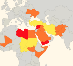
There is some evidence to suggest that more States are starting to provide better guidance and information to assist operators in making appropriate routing decisions, but we think this still has some way to go.

That is why we have been running our safe airspace map to provide guidance to assist operators in determining whether to avoid specific airspaces around the world.


Extra Reading:


European air traffic warned over Syria strikes

EASA are warning of possible air strikes into Syria being launched from locations within the LCCC/Nicosia FIR over the next 72 hours (Apr 11-14).

Eurocontrol have published a ‘Rapid Alert Notification’ on their website, with a statement from EASA that reads:

“Due to the possible launch of air strikes into Syria with air-to-ground and / or cruise missiles within the next 72 hours, and the possibility of intermittent disruption of radio navigation equipment, due consideration needs to be taken when planning flight operations in the Eastern Mediterranean / Nicosia FIR area.”

Very few commercial flights operate over Syria, and authorities in the US, UK, France and Germany have all previously issued warnings for Syrian airspace.

But many airlines regularly transit the LCCC/Nicosia FIR: there are frequent holiday flights to the main Cypriot airports of LCLK/Larnaca and LCPH/Paphos; overflight traffic from Europe to the likes of OLBA/Beirut, OJAI/Amman and LLBG/Tel Aviv; as well as traffic from Istanbul heading south to the Gulf and beyond.

Last year, two US warships in the eastern Mediterranean fired missiles at an air base in Syria after a chemical weapons attack by the Assad regime killed more than 80 people.

This week, following another suspected chemical attack by the Syrian government against civilians in a rebel-held town in Syria, the US President Donald Trump warned there would be a “forceful” response. On Apr 11, he took to Twitter to warn Russia to prepare for strike on Syria:

For the airstrikes on Syria last year, the US gave Russia advance warning of the attack, and Russian forces opted not to attempt to shoot down the missiles using its air defence systems stationed in the region.

However, this time round things could be very different. This week, Russia’s ambassador to Lebanon reminded the US that the head of the Russian military has said his forces in Syria would not only shoot down any missiles that threatened them but would target the source of the weapons as well.

The only US warship currently in the Mediterranean and capable of a possible strike is the USS Donald Cook, which left port in Larnaca and started to patrol in vicinity of Syria on Apr 9. According to some reports, it has since weighed anchor off Syrian territorial waters, and has been “buzzed” by low-flying Russian military jets.

Another 3 warships of the Sixth Fleet are already in the Atlantic Ocean, and on Apr 11 the entire US Truman Fleet (including an aircraft carrier, 6 destroyers, and nearly 6,500 sailors) departed Norfolk, Virginia, to head to the Mediterranean Sea. However, it may take up to a week for any of these warships to arrive.

Here’s an overview of US and coalition forces’ military options currently thought to be on offer in the eastern Mediterranean:

With the downing of MH17 by a surface-to-air missile over Ukraine in 2014, as well as all the recent unannounced missile tests by North Korea, there has been increased focus by the aviation community on the risks posed by conflict zones. If any missiles are launched from the Eastern Mediterranean in the next few days, be prepared for possible last-minute reroutes, as any Notams that get published may not give much warning.

Further reading:

One of our biggest missions in OPSGROUP is to share risk information and keep operators aware of the current threat picture. Check out Safeairspace for the most up-to-date information on airspace safety around the world.


Feb 2018: Tel Aviv Airport closes as a precaution against attack

LLBG/Tel-aviv: Israel’s main airport briefly suspended operations on Feb 10, due to military clashes along the northern border with Syria.

Two Israeli pilots were forced to abandon their F-16 jet, which crashed near the border after being hit by a Syrian anti-aircraft missile. The jet was on a mission in which it struck an Iranian facility in Syria that had previously operated a drone which Israel shot down over its territory.

This resulted in all flights from LLBG/Tel-aviv Airport being grounded for around an hour starting at 9am local time, as a precaution against any further attacks. The airport is considered a strategic location that could be targeted during military conflict.

Here’s what Israel’s PM had to say about it:

This incident marks the most significant engagement by Israel in the fighting that has been taking place in neighbouring Syria since 2011. Israel has mostly stayed out of the conflict so far, but has recently become more concerned about the increased Iranian presence along its border.


Missile attack on OERK/Riyadh was “warning shot”, other airports now targets

Update: Yemen-based Houthi forces fired another missile into Saudi Arabia on Dec 19. Saudi Arabia claim they intercepted it south of the capital Riyadh, with no damage or casualties reported, though a loud explosion was heard throughout the capital. The Houthi forces claim they were targeting a palace in southern Riyadh. This follows the previous Houthi missile attack on OERK/Riyadh Airport on Nov 4th, when they said: “the missile that targeted King Khalid airport was a warning shot and we warn all companies to prevent landing of their planes in the UAE and Saudi Arabia airports”. A Yemeni Army spokesman has said that the November 4 missile attack on OERK was a “warning shot”.

That missile was launched from rebel territory in Yemen, specifically targeting OERK/Riyadh King Khalid airport. Although most mainstream media carried the “missile was intercepted” story, we’re not sure that this is the case – even if it was, parts of it did fall on airport property and there was a visible explosion.

The spokesman said “the missile that targeted King Khalid airport was a warning shot and we warn all companies to prevent landing of their planes in the UAE and Saudi Arabia airports”.

Given that the Yemeni rebels have demonstrated their capability of reaching their target, there is some credibility to the threat.

Operators should consider this in operations to OE** and OM** airports.

At present, there is no indication of increased threat to overflight of Saudi or UAE airspace.

On Monday, the Saudi Arabia coalition closed all air, sea and land borders with Yemen after the missile strike on Riyadh on Nov 4, effectively closing all airports in Yemen. Yemenia airlines said that the coalition, which controls Yemen’s airspace, had declined it permission to fly out of Aden and Seiyun, the only two remaining functioning airports. OYSN/Sanaa has been closed since August 2016.

Also, all UN humanitarian flights to Yemen, one of the few international operators, have been cancelled after flights were no longer given clearance from the Saudi-led coalition to land in the country.

SCATANA remains active in the southwestern portion of the Jeddah FIR, no new Notams have been issued in relation to the last few days.

For further:

  • Monitor Saudi Arabia page on SafeAirspace
  • Monitor OPSGROUP member updates
  • Talk to us at team@fsbureau.org