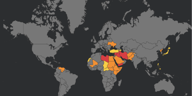
Assessing the Risk: Operations Over Conflict Zones

ICAO Doc 10084, if you have not come across it, is a sixty plus page document looking at ‘Risk Assessment for Civil Aircraft Operation Over or Near Conflict Zones’. Important stuff.

But despite manuals and procedures, regulations and recommendations telling us how to watch out for, assess, mitigate and manage the risk of conflict zones, there remains a much bigger and more significant risk to safety because of conflict zones.

So, what is this risk, and more importantly, what can we do about it in the aviation community?

Information

The huge hindrance to maintaining safety does not lie just with the SAMs themselves. It lies with information – the quality, quantity, reliability and promulgation of it. The result is that risk assessments are fundamentally flawed, understanding is limited and critical information does not reach those who need it.

So, there are four big points that need considering when we look at conflict zones and their impact on airspace safety:

  1. The Bigger Question – A risk assessment is much more than just asking “Is there a weapon down there?”
  2. Rules alone do not change the behavior of states – Information from states is critical, but it is often not shared, or not shared very well.
  3. Are we actively seeking information, or simply waiting for it to come our way? – The safety process does not stop at the state level, it continues (should continue) dynamically with operators and with the pilots, so understanding the situation is important.
  4. How can we do better? – Individuals and the industry have a responsibility to ensure information and strategies are shared.

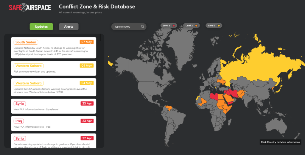
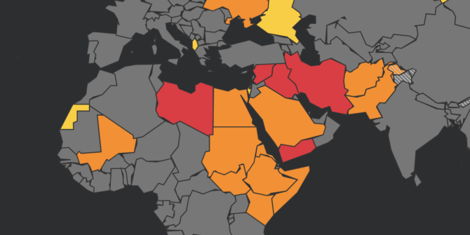
SafeAirspace main page

1. The Bigger Question

The bigger question is to do with how risk is assessed, and it is a complex process even when information is available.

ICAO Doc 10084 lays out the risk assessment process. It’s an interesting read and worth taking a few minutes to think about because understanding the background to conflicts and what the key factors at play are is the only way for safety strategies and risk assessments to continue, and continue they should – it does not stop when a Notam is released.

The process is dynamic and needs to continue with the operator and the pilots too.

What are the key factors in a risk assessment?

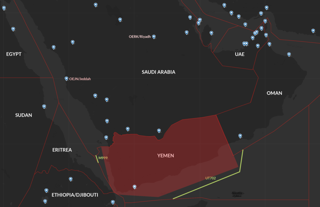
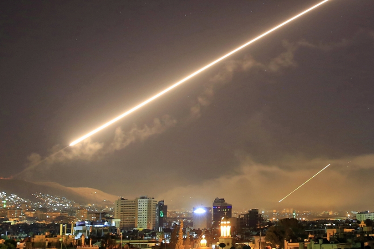
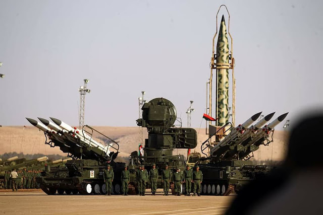
First up, what are we actually talking about here? Long-range Surface-to-air missiles (SAMs) can reach aircraft cruising in excess of 25,000ft (7600m). They are often linked with radar sensor systems to help identify targets, and are mobile and easily and quickly relocated.
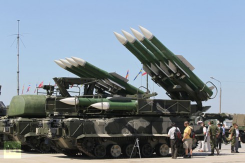
Russian mobile SAM

So we need an assessment of what danger these pose to airlines and airplanes, and this means we need to know who has them (the capability) and also their intent (who or what do they plan to target).

But it is not that simple. Where there is intent, there is not always capability; and as importantly, where there is capability there is not always intent. The Iranian shoot down is a clear example of this. So we also need to consider the unintentional risks as well.

The questions asked look something like this:

  • Is there use of military aircraft in combat roles or for hostile reconnaissance (including unmanned aircraft)?
  • Are aircraft used to transport troops into the area and do these routes coincide with civil air corridors, or lie close and so pose a risk of misidentification between civil and military aircraft operating in the area?
  • What are the politics relating to the region?
  • What are the training levels of SAM operators and what is the military deployment of SAMs? How reliable and credible is the information shared by the state regarding this?
  • Is there a lack of effective air traffic management over the relevant airspace? Is the state fully in control of their own territory and do they fulfil all their ATC, coordination and promulgation (of information) obligations?
  • Do civil aircraft route pass over or close to locations or assets of high strategic importance or which may be considered vulnerable to aerial attack in a conflict situation?

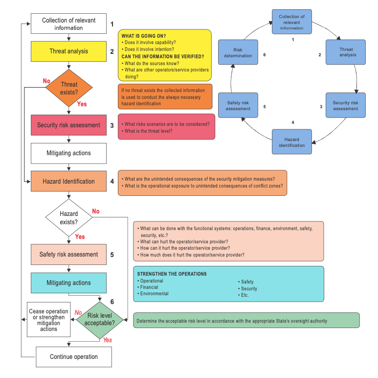
The Risk Assessment cycle is worthless if Point 1 – the collection of relevant information – is flawed

But, the risk continues beyond this initial assessment because we also have to identify any ongoing consequences of an event. If a major airport is targeted, the impact is not only with the initial damage – if that initial damage is to the ATC systems required to maintain control and separation of aircraft then now we have reduced safety in the airspace and a much larger level of disruption.

So, we must think about the overall severity, and with that the tolerability of an infrastructure or operation. We are asking both ‘What can it hurt?’ and ‘How much it will hurt?’ 

This assessment, according to the ICAO document, is thrown into a matrix and churns out a ‘Risk Level’ which leads to the actions taken. 

pastedGraphic.png

The Matrix for Recommended action

Sounds simple, but there is one key point here – 

This info is not easy to come by. It is rarely reliable, and there is a qualitative narrative that makes it very subjective. The information has to be promulgated from states.

Which leads us to Point Number 2.

2. Rules do not change the behavior of a state….

States are responsible for sharing info on hazards, on what mitigation strategies they have in place, and the assessed impact of the strategies they adopt.

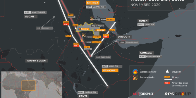
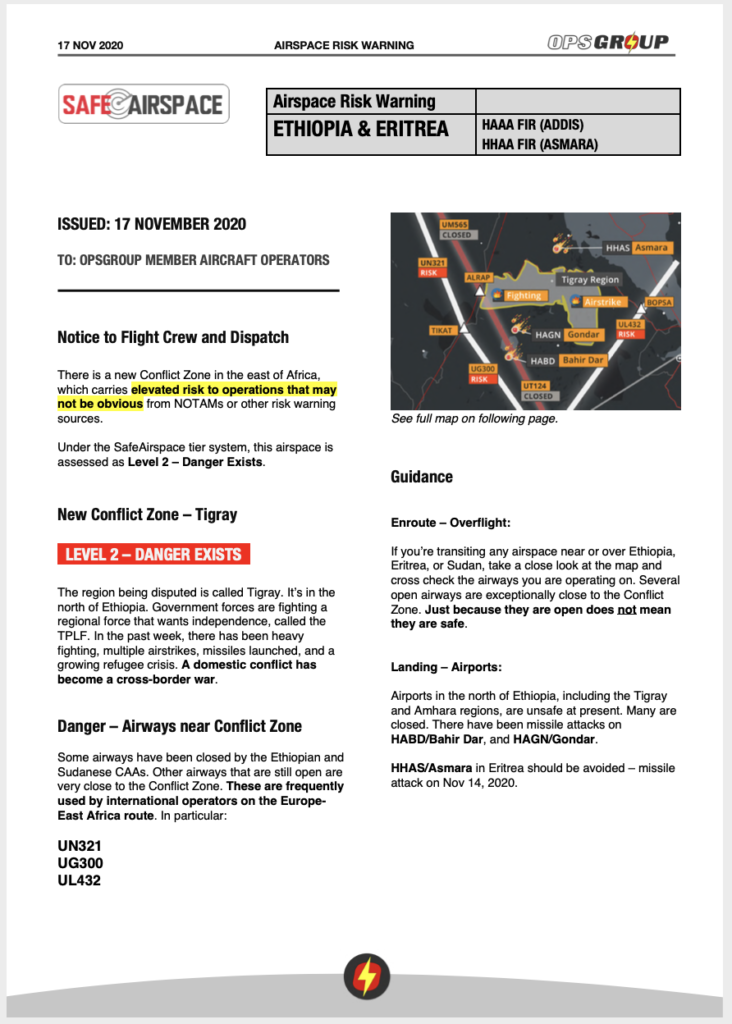
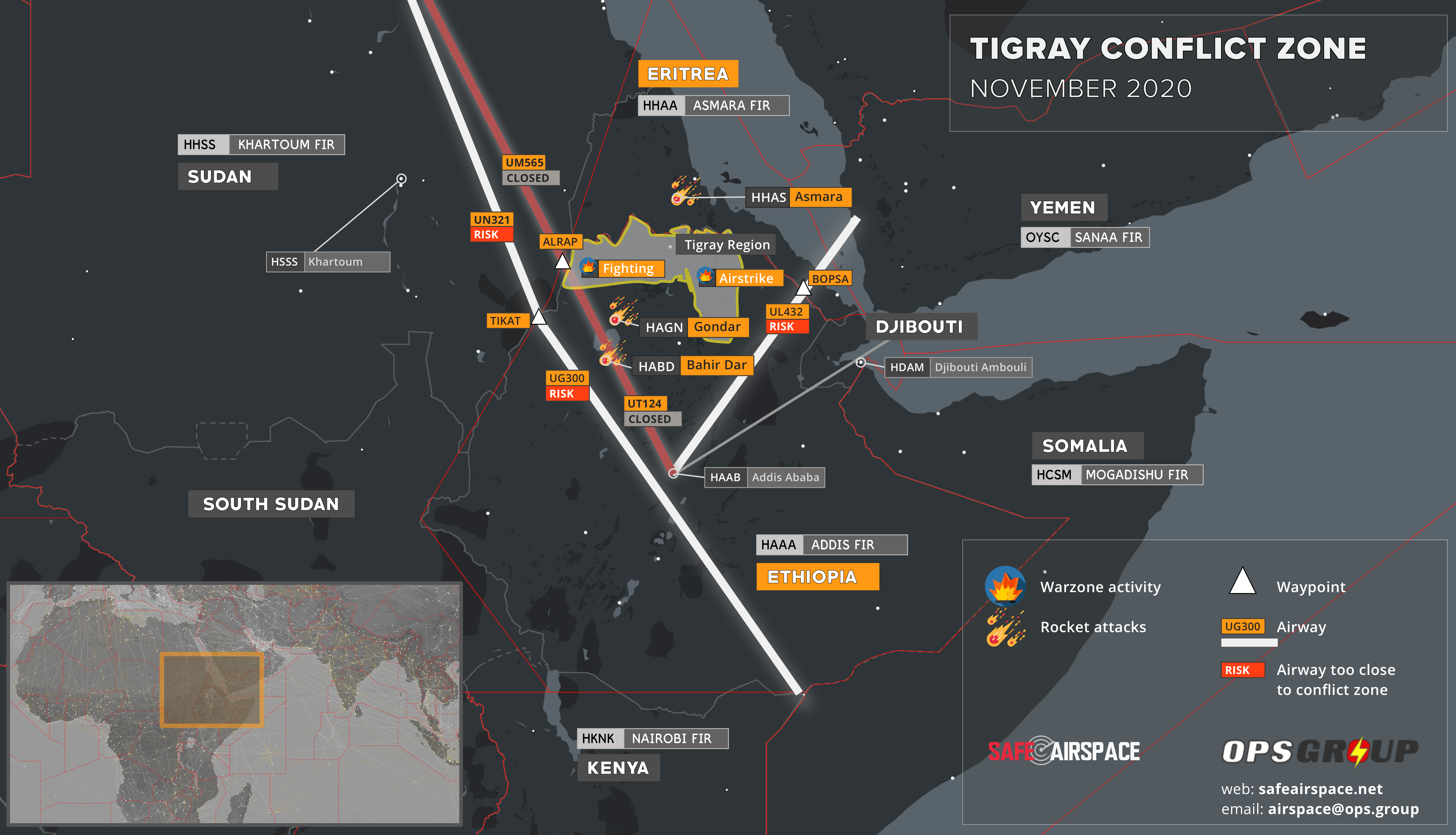
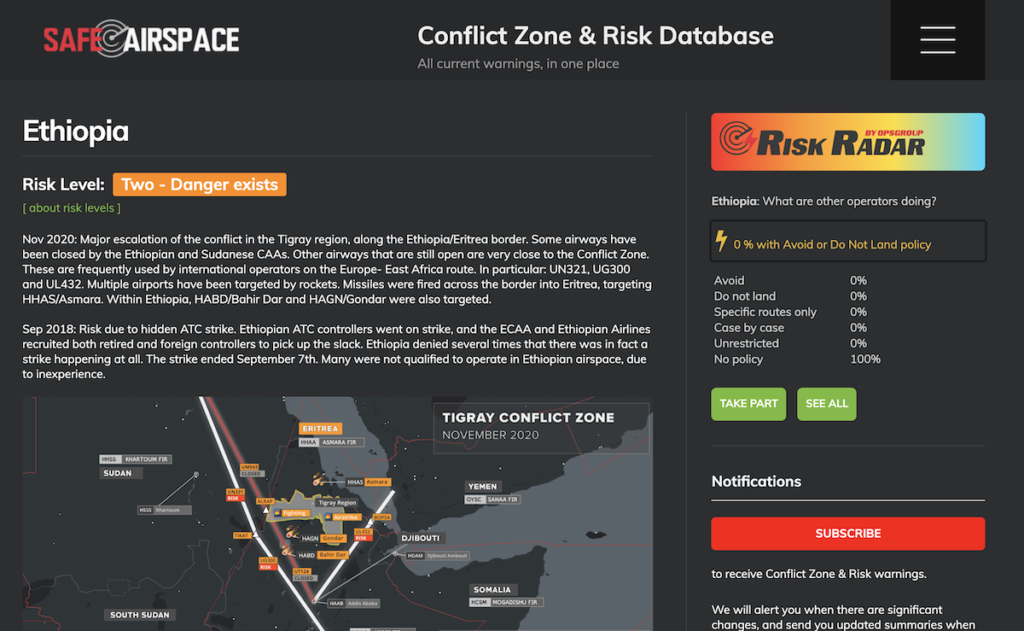
This often does not happen, or it does not happen well. Look at Ethiopia/Tigray region situation – misleading Notams and no guidance from the Ethiopian authorities led to Opsgroup issuing our own warning regarding the situation.

Further to that, ICAO only mandated the reporting of hazards in notices to pilots since 2020, and some states are still failing to do so.

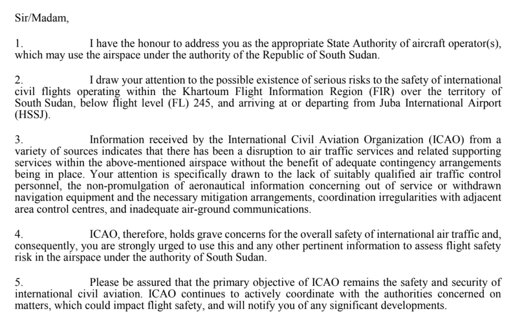
Letter issued by ICO highlighting concerns in South Sudan

3. People are not seeking information, they are waiting for it to come their way

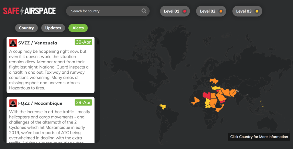
This is why SafeAirspace was created.

Information is not being shared well and risk assessments are fundamentally flawed because the information on key factors is simply not available or reliable most of the time.

What’s more, people are rarely questioning whether the information they received was reliable, accurate or complete. Few proper risk assessments are taking place because those responsible are waiting for the information to come to them, and without a proper risk assessment, mitigation strategies are not sufficient, and are not being passed on to those who need them – the pilots.

The information we provide on SafeAirspace

What is the Operator’s continued role in the process?

Every operator is responsible for continuing the risk assessment. It is not enough to simply direct crew to a Notam. Ensuring crew have a full briefing on the threat and any mitigation strategies is important.

  • Emergency and abnormal procedures should be considered in advance. Take Mogadishu airspace where only flights on specific airways over the water are allowed. What is the strategy here in case of an engine failure or depressurization? If you operate over this region, you should have access to this information.
  • Operators are also responsible reviewing fuel requirements – ensuring additional fuel is provided for potential diversions around conflict zones.
  • If aircraft will be operating into conflict zones, then a review of MEL items which can be deferred is a good call – can the aircraft get out again without requiring maintenance or fueling?

What is the pilot’s continued responsibility in the process?

The information and strategies we see at the operations end are things like these:

  • Coordination between military authorities, security and ATS units
  • Briefings of personnel
  • Identification of civil aircraft by military units
  • Issuance of warnings and navigation advice
  • Air Traffic Restrictions
  • Closure of Airspace

But this does not mean the full risk has been removed. Understanding this, understanding how the situation got to this point, and understanding the risk assessment and safety management that has taken place is vital because the process now continues with you, the pilot, and this a fundamental step in continuing to manage safety.

  • The Crew, and the Commander of the aircraft are responsible for the safety of the aircraft and the passengers. Of course, we all know that, but if you are given a Notam saying “this airspace ain’t great, maybe avoid it” and then you fly through it, where does the responsibility of your operator end and yours begin?
  • Reading notams, the AIPs, AICs, and being aware of the threats of the airspace you might be asked to operate into is vital. More than that, ensure you are aware of any mitigation strategies required.
  • Pre-prepare for diversions and know where you can safely go. Some diversions might take you through prohibited airspace so if you are operating in the vicinity of some, have a route ready in box two so you can easily avoid airspace when you need to.
  • Be aware of security threats and hazards on the ground, in advance.
  • Consider the serviceability of aircraft equipment before you go – critical equipment would be communication systems, and those required to ensure military units can identify them as civilian;
  • Have an awareness of the potential political implications if diverting into some regions with certain nationalities onboard. If you divert there, what will happen to your passengers and crew, and why?
  • Report things. Keep the information loop going.

Send in AirportSpy reports on hazards and security concerns

4. How can we do better?

Aeronautical info from states and authorities is your first point of call. AICs, AIPs and Notams are going to contain info on advisories, restrictions and recommendations.

If you are an FAA operator, then the FAA put out KICZ notams and this page has all the current ones for airspace.

Networks and organizations such as us here at OPSGROUP try to share relevant and up-to-date information on airspace, conflicts and the risks that are out there.

Open sources like social media and news sites are also good – but be careful, these may come from unconfirmed or unreliable sources. We recommend checking info with other sources too, like handling agents in the area.

Finally, talk to other pilots and operators, and be sure to report information you have from operating in or through airspace.


Chad Airspace Update

Chad’s long term President, Idriss Déby died this week, having spent more than three decades in power as one of Africa’s longest-serving leaders. So why did his death result in the temporary closure of the country, and what is the impact to aviation?

The background

Chad is a large landlocked country in Africa, bordered by Sudan, Libya, the CAR, Cameroon,Nigeria and Niger.

Déby was focused on building a more democratic society and he had strong allies in France and with other Western powers through his continued fighting against Jihadist groups. Provincial elections were already underway with projections suggesting he would be successful in winning a sixth term.

However, Chad is also one of the poorest nations in the world, with big problems around poverty, corruption and human rights, and with that came civil unrest.

What happened?

Déby was injured during a visit to troops who were battling against rebels belonging to a group called Fact (the Front for Change and Concord in Chad). The big concern now is who will become the next leader – Déby’s son has stepped in – but the government has been dissolved and conflict is escalating in the country as opposing parties fight for power.

The military elected initially to close land and maritime borders, but then closed all airports as well, whilst putting in a strict countrywide curfew.

The Impact for Aviation

Initially, a Notam was issued stating that FTTJ/Ndjamena airport was closed, and that Contingency Procedures were in effect across the FTTT/Ndjamena FIR. Then a couple of days later, on Apr 21, the Notam was cancelled and the US Embassy issued a Security Alert advising that FTTJ airport has reopened.

In the short term however, landings are not advised, and overflying aircraft should be familiar with Contingency Procedures. You can download the Contingency Plan from the Acesna AIP here.

This plan lays out the arrangements for situations where the Air Navigation Services are partially or totally disrupted, and aims to ensure overflights remain possible. Effectively, it aims to coordinate with neighboring ATS units so control of the N’Djamena UIR is temporarily assigned to them – Brazzaville ACC and Niamey ACC are the primary units being used.

Pilot operating procedures while Contingency Procedures are activated are shown under section 8.3 and the advises the following:

  • Maintain contact with Brazzaville or Niamey control until entering, and contact the next control at least 10 minutes prior to exiting.
  • Operate along the assigned contingency route (as listed in the table), although SLOP is recommended.
  • Reach your assigned level at least 10 minutes prior to entering N’Djamena UIR and maintain throughout unless an emergency arises requiring you to diverge from it.
  • Listen out on 12.6 and transmit position reports.

What else do we know?

N’Djamena in the past was a popular fuel stop in central Africa, but multiple travel warnings now advise against travel here (see the UK advice here, and the US advice here). No official state Notams have been issued, but risk remains high. A state of emergency remains in place for the Lake Chad region. Overall there is a high threat for terrorism and it is strongly advised to avoid landings.


SafeAirspace: 2021 Update

2020 was a heck of a ride. But therein lies the risk – what else might you have missed amongst all the Covid-related noise? Sadly, conflicts and their risks to civil aviation have not taken a break during the pandemic.

As it’s a new year, we thought a summary of Airspace Risk was called for. Here’s what’s making headlines at the moment:

Saudi Arabia & Yemen

Houthi rebels in Yemen are regularly firing explosive drones and rockets across the border into Saudi Arabia, and these usually target airports in the south such as OEAH/Abha and OEGN/Jizan. Their latest attack was on OYAA/Aden airport in late December which resulted in mass casualties.

Saudi Arabia continues to retaliate with airstrikes. The latest was in the capital Sanaa just weeks ago, where multiple munitions landed near the airport.

The risk to aviation is that overflying aircraft may get caught in the crossfire or might be misidentified by Saudi air defences. Active terrorist groups in Yemen may also use anti-aircraft weaponry to target foreign interests.

The FAA prohibit all US operators from entering most of the OYSC/Sanaa FIR at any level. Only two airways are allowed, and they are well off the coast – UT702 and M999.

There are no restrictions on Saudi Arabia but use caution in the southern regions. France and Germany have issued their own warnings.

SafeAirspace Yemen page – click here.
SafeAirspace Saudi Arabia page – click here.

Iraq

Rocket attacks on military interests at airports have become a common occurrence. They are generally fired by local militia without warning. ORBI/Baghdad is frequently targeted, along with other airports including ORER/Erbil. There is a clear risk to aircraft at low levels.

US relations were further strained through 2020 with multiple attacks on the US embassy in Baghdad. The tensions escalated to a point where the US considering closing it.

Foreign aircraft continue to be at risk from armed militia who have access to portable anti-aircraft weaponry, while misidentification by the air defence systems of multiple foreign forces in the country is also possible.

The FAA has extended its ban on US operators entering the Baghdad FIR at any level. Even though the SFAR says you can enter above FL320, the long-running Notam KICZ A0036/30 says otherwise.

SafeAirspace Iraq page – click here.

Syria

There have been several recent Israeli airstrikes on targets throughout Syria. In late December there are reports that Israeli fighters transited Lebanese airspace at low level causing alarm in Beirut before attacking targets in Western Syria. Just weeks ago, several sites around Damascus were targeted by Israeli missiles.

The primary risk is that aircraft may be misidentified by Syrian air defence systems which are regularly activated. Civil operators may get caught in the crossfire as missiles may erroneously lock on to the wrong aircraft.

The FAA are taking no chances – the ban on US operators entering the OSTT/Damascus FIR at any level has been extended a full three years to 2023.

SafeAirspace Syria page – click here.

South Sudan

Just this week ICAO issued a concerning warning about the risk to aircraft operating below FL245 in the HSSX/Khartoum FIR over South Sudan, or flying in and out of HSSJ/Juba. They are ‘gravely’ concerned about ATC disruptions, a lack of contingencies, inadequate training of controllers, limited info about equipment outages and a lack of co-ordination with other ATS units.

SafeAirspace South Sudan page – click here.

Emerging Conflict Zones

2020 saw three new conflict zones emerge, here is what is happening with them now.

Ethiopia

A civil conflict erupted in October last year in the Tigray region of Northern Ethiopia. The government went to war with the TPLF – a regional force seeking independence.

The region’s airports were closed and TPLF showed an intent to internationalise the conflict by attacking aviation interests. They fired rockets into Eritrea targeting HHAS/Asmara, and also attacked multiple airports to the South of the Tigray region.

Two airways were closed (T124, and M308) with no explanation of the risk.  Other airways remained open but uncomfortably close to the fight – especially UG300, UN321 and UL432. No airspace warnings were issued despite the dangers.

What’s the latest?

In late November Ethiopian forces captured the region’s capital Mekelle and regained control. Remaining TPLF forces have retreated leaving behind a humanitarian disaster and a vow to continue the fight. Since then, the airway closures have been removed and things have gone quiet, but an airspace risk remains – armed militia continue to be active in Northern regions and may be looking to make a statement. Be wary of operating in the area.

Western Sahara

Late last year the region’s independence movement (the Polisario) declared war on Morocco for breaching a ceasefire agreement. The FAA published a warning that the Polisario might have access to anti-aircraft weaponry left over from previous conflicts.

What’s the latest?

It is still an active conflict zone.  The fight has reached the international stage after the US declared their support for Morocco. The Polisario have indicated they are willing to at least talk, but so far have not put down their weapons. So, it is a wait-and-see type deal.

The risk to overflying aircraft remains. The GCCC/Canarias FIR keep extending a Notam advising operators to not fly below FL200 on the following airways: UY601, UN728 and UT975.  However, the reason is still missing: because of the risk of anti-aircraft fire. The GOOO/Dakar FIR haven’t issued any warnings despite the threat. Take care if operating in the area.

Armenia-Azerbaijan

In September last year, an ethnic conflict erupted over a disputed territory in Western Azerbaijan – Nagorno-Karabakh. The fight was between Azerbaijan and Armenia.

As a major air corridor for en-route traffic, there were significant flight disruptions. Azerbaijan swiftly closed all but one west/eastbound airway and routed traffic via Georgia. Armenia asked aircraft to take extra fuel and expect re-routes. The conflict was short but intense, with heavy artillery fire from both sides. The conflict eventually spread beyond the contested regions with longer range weapons. The entire border region posed a risk for civil aircraft.

What’s the latest?

For once the news is good. In November a ceasefire agreement was signed with the help of Russia. Armenia effectively lost and withdrew from the region and the conflict was officially over. Armenia removed its airspace warning, while Azerbaijan re-opened the affected airways and a large section of airspace near the border.

With the conflict now over, and no new reports of significant fighting since the peace agreement in November, direct crossing traffic between the two countries is now technically possible again.  However, most East-West flights are currently still electing to go further north instead, connecting between Azerbaijan and Georgia’s airspace, avoiding Armenia.

What about Safeairspace.net?

Our conflict zone and risk database is updated constantly. We assess risk with official sources and build a simple picture for you of those need-to know-places.

There are currently 5 regions which are assessed as a Level 1 Risk – No Fly. These are: Iraq, Iran, Yemen, Libya, and Syria.

Head over to SafeAirspace.net and take a look. With a single click you can download a risk briefing of the entire world in just a few pages of nice simple English.

The mission of SafeAirspace is this: to provide a single, independent, and eternally free resource for all airspace risk warnings, so that airlines and aircraft operators can easily see the current risk picture for unfamiliar airspace. If you know of a risk not listed on the site, or you have anything else to add, please get in touch with us at news@ops.group


Airspace Risk Warning – Ethiopia and Eritrea

There is a new Conflict Zone in the east of Africa, which carries elevated risk to flight operations that may not be obvious from NOTAMs or other risk warning sources.

Some airways have been closed by the Ethiopian and Sudanese CAAs. Other airways that are still open are very close to the Conflict Zone. These are frequently used by international operators on the Europe- East Africa route. In particular: UN321, UG300 and UL432. We are concerned that operators may be using these routes without being aware of the risk.

OPSGROUP has today issued an Airspace Risk Warning to its members.

Download OPSGROUP Airspace Risk Warning – Ethiopia/Eritrea (PDF)


Download Hi-Res version of this Conflict Zone map


Situation

The region being disputed is called Tigray. It’s in the north of Ethiopia. Government forces are fighting a regional force that wants independence, called the TPLF. In the past week, there has been heavy fighting, multiple airstrikes, missiles launched, and a growing refugee crisis. A domestic conflict has become a cross-border war.

Our Concerns

There are many warning flags that point to previous shootdown incidents – not least MH17 and PS752. These are the reasons we are particularly concerned about the risk to civil aviation in this region:

Local NOTAMs are misleading
The NOTAMs issued by the Ethiopian CAA to close airways in the conflict zone (UM308, UT124) do not say why they are closed. NOTAMs issued to reroute traffic to adjacent routes (UN321, UL432) do not say why they are rerouted. The same applies to NOTAMs issued by the Sudan CAA to close airways and reroute traffic. Flight crews and aircraft operators are therefore not alerted to any conflict in the area by NOTAM.

Arbitrary Reroutes
Traffic is being rerouted to other airways by ATC, but it’s not clear, or likely, that there has been any risk assessment. European flights are now using UN321/UG300, and UL432 – all of which come exceptionally close to the conflict zone. As we’ve learned from MH17 and PS752, just because airspace is open and available, does not mean it is safe.

Previous shootdowns
The Ethiopian Army shot down an Embraer 120 in May 2020, in Somalia. The Ethiopian Air Force shot down a US Learjet in August 1999 in the Eritrean border region. Both were misidentified.

No guidance to operators
No aviation authorities or official sources have issued any guidance or warnings to date via normal channels.

Rapid Escalation of Conflict
The situation has intensified rapidly, and is extremely unpredictable and unstable. The impact on aviation has not been widely reported.

Guidance

Enroute – Overflight:
If you’re transiting any airspace near or over Ethiopia, Eritrea, or Sudan, take a close look at the map and cross check the airways you are operating on. Several open airways are exceptionally close to the Conflict Zone. Just because they are open does not mean they are safe.

Landing – Airports:
Airports in the north of Ethiopia, including the Tigray and Amhara regions, are unsafe at present. Many are closed. There have been missile attacks on HABD/Bahir Dar, and HAGN/Gondar. HHAS/Asmara in Eritrea should be avoided – missile attack on Nov 14, 2020.

Information Sources

The Conflict Zone & Risk Database at SafeAirspace.net contains all current published warnings and alerts for Ethiopia and Eritrea.

The countries that issue the most relevant updates for unsafe airspace are:

• US (FAA) – through Notams and SFARs
• UK (DFT) – by Notam and then AIP
• Germany (BMVI) – by Notam
• France (DGAC) – by AIC

Note: Operators should not rely on EASA Conflict Zone Information Bulletins (CZIB)’s as a primary source of information. These serve only as pointers to the above sources, and often are not issued until several months after updates, if at all. Note that the Civil Aviation Authorities of the countries whose airspace is determined to be unsafe are unlikely to issue reliable guidance.

Group effort

This information is compiled from OPSGROUP member input, information, intelligence and analysis. If you have additional information to share, please send it to report@safeairspace.net.

Members: More information

OPSGROUP Members: More information in the discussion in the Forum about Ethiopia/Eritrea:
Forum > International Ops > New Conflict Zone Ethiopia/Eritrea

All links to further resources are there.


Libya Airspace Update Oct 2019

On 23rd Oct 2019, the US issued an emergency order prohibiting U.S. operators from flying in Libyan airspace. The guidance here is very clear: do not operate anywhere in the HLLL/Tripoli FIR, at any flight level.

This follows months of civil war in Libya, with militia from the east mounting a campaign to seize control of Tripoli, including HLLM airport, and threatening to shoot down aircraft operating in western Libya.

In recent months there have been a number of airstrikes targeting HLLM/Mitiga airport, the latest coming on Aug 15, which reportedly killed two people and forced the airport to close. There are videos on social media showing planes landing at the airport as shells are falling in the background.

Prior to yesterday’s announcement, the U.S. guidance on Libya was that operators were allowed to overfly Libya at FL300 or above, except an area in the north-western part of the country over Tripoli, where all flights were prohibited. Here’s what that looked like:

But this guidance is now defunct. The FAA website now shows the updated guidance for Libya – including the Background Notice.

Germany and Malta still have warnings in place which mirror the old advice of the U.S. – do not fly over the north-western part of Libya, but overflights of the rest of the country are permitted at the higher flight levels. The UK and France advise against all overflights. These warnings may be updated in the coming days, following the new advice from the U.S.

Libya remains politically unstable, with a fragile security situation across the country. In their SFAR issued back in March 2019, the U.S. said that the main threat to aviation at the lower flight levels stems from the widespread proliferation of man-portable air-defence systems (MANPADS) across the country:

“Both GNA and advancing LNA forces have access to advanced man portable air defense systems (MANPADS) and likely anti-aircraft artillery. These ground-based weapon systems present a risk to aircraft, but only at altitudes below FL300. LNA forces have tactical aircraft capable of intercepting aircraft at altitudes at and above FL300 within the self-declared military zone in Western Libya, which may present an inadvertent risk to civil aviation operations in Western Libya. While the LNA tactical aircraft threat is likely intended for GNA military aircraft, an inadvertent risk remains for civil aviation at all altitudes due to potential miscalculation or misidentification.”

However, there are factions on the ground in Libya which possess weapons capable of targeting aircraft above FL300. The LNA is one of many armed groups in Libya which continues to use various rocket systems looted from Gaddafi’s stockpiles at the end of the war in 2011. In May 2018, the LNA proudly displayed a refurbished Russian-made surface-to-air missile system at HLLB/Benina Airbase in Benghazi. This system has the capability to engage aircraft at altitudes up to FL450.

The opposing GNA forces have surface-to-air missile systems of their own. Some reports indicate that the GNA are in possession of the Russian-made SA-3 system, which has the capability to engage aircraft at altitudes over FL800.

With the current conflict between these and other rival factions on the ground in Libya now escalating, it’s not clear what level of control the main players hold over their missile systems.

Bottom line, there’s still a potential risk to aircraft at all altitudes and across all parts of Libya.

Even if you are allowed to overfly the country, there are only two approved routes available, in the far north-eastern corner of the country, as per HLLL Libyan Notam A0063/17:

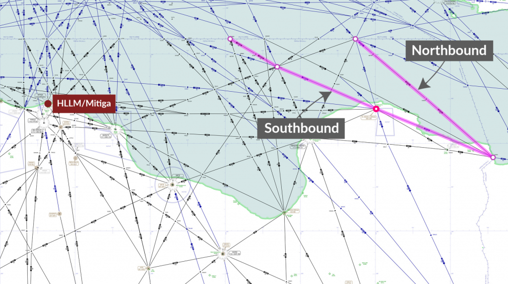
Northbound: LOSUL UP128 LAB UM979 RAMLI UZ270 OLMAX (even levels)
Southbound: RASNO UY751 LOSUL (odd levels)

Even on these routes, reliable ATC services cannot be guaranteed. The past few years have seen regular ATS and radar outages across the HLLL FIR airspace, and severe limitations in VHF capability, with operators having to communicate with Malta ATC for guidance.

Given the current security concerns, we continue to list the entire country as “Level 1 – Avoid” at SafeAirspace.net


“THIS NOTAM IS AN EMERGENCY ORDER” – FAA on Venezuela

At 8.30pm tonight, the FAA issued a new “Do Not Fly” instruction to US operators, barring all operations into or over Venezuela, unless operating at or above FL260, and giving a window of 48 hours to leave the country.

The order comes on a day of an information battle waged between Maduro and Guaidó, and although the coup status is uncertain, one thing is clear: taking your aircraft to Venezuela is not a good idea.

The new Notam, KICZ A0013/19, has as postscript: “THIS NOTAM IS AN EMERGENCY ORDER ISSUED UNDER 49 USC 40113(A) AND 46105(C).” It gives US operators 48 hours to leave Venezuela.

Over the past year, the situation in Venezuela has steadily declined, and in OPSGROUP we have issued multiple alerts and warnings, most recently today, on the back of several member reports:

The Venezuelan authorities had also published a Notam on 30 APR banning all GA/BA flights from operating to/from airports in the country, but this has since been cancelled.

The new FAA Notam leads with:

“ALL FLIGHT OPERATIONS IN THE TERRITORY AND AIRSPACE OF VENEZUELA AT ALTITUDES BELOW FL 260 BY THE PERSONS DESCRIBED IN PARAGRAPH A BELOW ARE PROHIBITED UNTIL FURTHER ADVISED DUE TO INCREASING POLITICAL INSTABILITY AND TENSIONS IN VENEZUELA AND THE ASSOCIATED INADVERTENT RISK TO FLIGHT OPERATIONS.”

and is issued as a Permanent Notam with no expiration date.

Rerouting options for overflights choosing to avoid, would be either west via Colombia, or east via Guyana and Piarco.

The full FAA Notam text is below. SafeAirspace.net is now updated with the new information.

FAA Notam KICZ A0013/19 issued May 1st, 2019, 0025Z.:

KICZ A0013/19 – SECURITY..UNITED STATES OF AMERICA PROHIBITION FOR
VENEZUELA

ALL FLIGHT OPERATIONS IN THE TERRITORY AND AIRSPACE OF VENEZUELA AT ALTITUDES BELOW FL
260 BY THE PERSONS DESCRIBED IN PARAGRAPH A BELOW ARE PROHIBITED UNTIL FURTHER ADVISED
DUE TO INCREASING POLITICAL INSTABILITY AND TENSIONS IN VENEZUELA AND THE ASSOCIATED
INADVERTENT RISK TO FLIGHT OPERATIONS.

A. APPLICABILITY. THIS NOTAM APPLIES TO: ALL U.S. AIR CARRIERS AND COMMERCIAL OPERATORS;
ALL PERSONS EXERCISING THE PRIVILEGES OF AN AIRMAN CERTIFICATE ISSUED BY THE FAA, EXCEPT
SUCH PERSONS OPERATING U.S.‐REGISTERED AIRCRAFT FOR A FOREIGN AIR CARRIER; AND ALL
OPERATORS OF AIRCRAFT REGISTERED IN THE UNITED STATES, EXCEPT WHERE THE OPERATOR OF
SUCH AIRCRAFT IS A FOREIGN AIR CARRIER.

B. PERMITTED OPERATIONS. THIS NOTAM DOES NOT PROHIBIT PERSONS DESCRIBED IN PARAGRAPH
A (APPLICABILITY) FROM CONDUCTING FLIGHT OPERATIONS IN THE ABOVE-NAMED AREA WHEN
SUCH OPERATIONS ARE AUTHORIZED EITHER BY ANOTHER AGENCY OF THE UNITED STATES
GOVERNMENT WITH THE APPROVAL OF THE FAA OR BY A DEVIATION, EXEMPTION, OR OTHER
AUTHORIZATION ISSUED BY THE FAA ADMINISTRATOR. OPERATORS MUST CALL THE FAA
WASHINGTON OPERATIONS CENTER AT 202-267-3333 TO INITIATE COORDINATION FOR FAA
AUTHORIZATION TO CONDUCT OPERATIONS.

C. ALLOWANCES. PERSONS DESCRIBED IN PARAGRAPH A ABOVE WHO ARE IN THE TERRITORY AND
AIRSPACE OF VENEZUELA AT THE TIME THIS NOTAM IS ISSUED MAY DEPART THE TERRITORY AND
AIRSPACE OF VENEZUELA BY THE MOST EXPEDITIOUS POSSIBLE ROUTE WITHIN 48 HOURS FROM THE
TIME THIS NOTAM IS ISSUED, IF THE PILOT IN COMMAND DETERMINES THAT THE OPERATION CAN
BE CONDUCTED SAFELY.

D. EMERGENCY SITUATIONS. IN AN EMERGENCY THAT REQUIRES IMMEDIATE DECISION AND ACTION
FOR THE SAFETY OF THE FLIGHT, THE PILOT IN COMMAND OF AN AIRCRAFT MAY DEVIATE FROM THIS
NOTAM TO THE EXTENT REQUIRED BY THAT EMERGENCY.

THIS NOTAM IS AN EMERGENCY ORDER ISSUED UNDER 49 USC 40113(A) AND 46105(C).
SFC – FL259; 01 MAY 00:25 2019 UNTIL PERM. CREATED: 01 MAY 00:28 2019