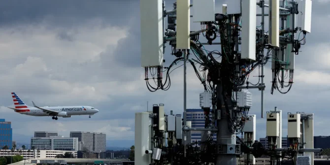
US will not delay 5G aircraft retrofit deadline

Telecoms firms will be rolling out 5G near major US airports from July 1, 2023. Most aircraft need to upgrade their radio altimeters by this date to continue certain operations, and the FAA has said it will not be extending the deadline.

What do you mean by “certain operations”?
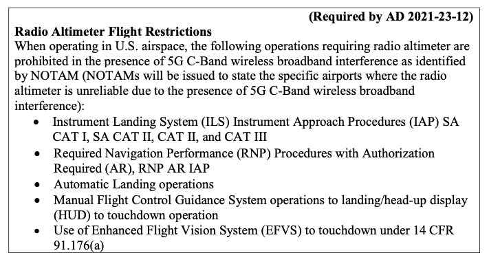
These ones:

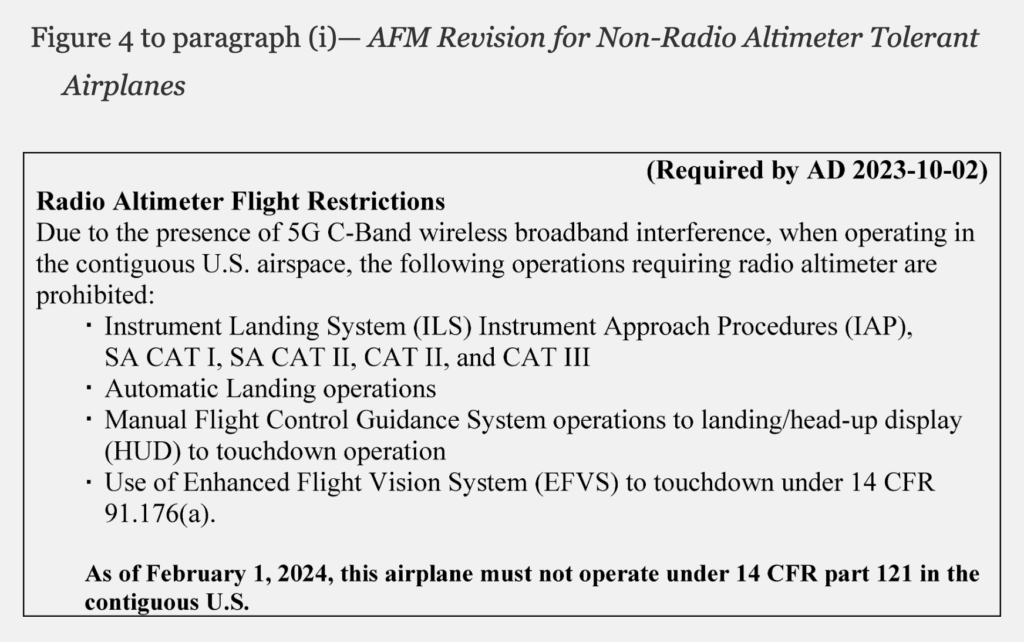
  • Special Authorization CAT I, CAT II and above approaches.
  • Auto-landings.
  • Head-up display landings.
  • Enhanced vision systems through touchdown.

For ease of reference, we’re going to call these “fancy landings” for the rest of this article.

What do you mean by “most aircraft”?

Aircraft that need to do this are “Transport and Commuter Category Airplanes.” Just like it says in the FAA rules!

What FAA rules?

The initial set of rules (Airworthiness Directive 2021-23-12) was published in Dec 2021. But that got superseded in May 2023 (right at the death, with only 1.5 months to go until the July 1st deadline!) with Airworthiness Directive 2023-10-02. This really is the place to go to find answers to all questions.

The rules set two deadlines:

July 1, 2023: All transport and commuter category airplanes, regardless of the type of operation (Part 91, Part 135, Part 121), will be prohibited from performing these fancy landings at any US airport unless they have upgraded their radio altimeters. Aircraft without upgraded radio altimeters will be able to operate into any airport, but cannot fly the fancy landings.

Feb 1, 2024: US aircraft operating under Part 121 need to have upgraded their radio altimeters to be able to operate anywhere in the contiguous US.

What are “transport and commuter category airplanes”?

Commuter Airplanes = multi-engine, max pax seats 19, max takeoff weight of 19,000lbs. If you have more than 19 seats, or you’re heavier than 19,000lbs, that makes you a Transport Airplane.

So this basically means everyone.

EVERYONE everyone? Or just N-reg aircraft?

Yeah ok, not EVERYONE everyone. The rules only apply to N-reg aircraft.

So, technically, if you’re not N-reg you can carry on flying the fancy landings in the US after July 1st even if you haven’t upgraded your radio altimeter. But that’s probably not a great idea, because the 5G interference is still going to be an issue for you!

As the FAA says in the rules (in response to no fewer than eleven foreign airlines who asked this very same question):

“Under ICAO Annex 8, Airworthiness of Aircraft, the state of registry of an airplane 
is the state responsible for its airworthiness. For this reason, FAA ADs apply only 
to U.S.-registered airplanes. To the extent the FAA's bilateral partners agree with 
the FAA's finding of an unsafe condition in U.S. airspace, the FAA encourages those 
authorities to adopt the FAA AD or similar requirements as mandatory continuing 
airworthiness instructions for airplanes registered in other countries. 
The FAA also plans to publish information in the FAA's Aeronautical Information 
Publication to alert international operators to the 5G C-Band situation in the U.S., 
including the agency's use of Domestic Notices. The FAA strongly urges operators of 
foreign-registered airplanes to voluntarily comply with the actions required by this 
AD when operating in the contiguous U.S. given the unsafe condition affects their 
airplanes as much as the airplanes subject to this AD.”

What if I don’t care about these fancy landings?

If you’re N-reg but don’t have approvals to do these fancy landings, you don’t need to worry – no radio altimeter upgrade is required.

Before July 1st, just stick this table into your AFM, and you’re done:

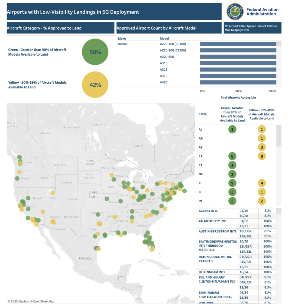
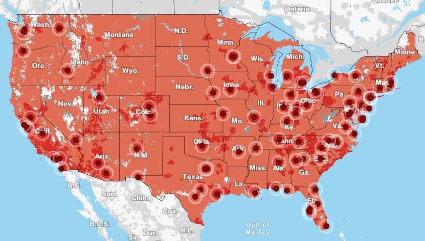
Which airports are affected?

Right now, there are almost 200 US airports with 5G interference issues. The FAA has an interactive map of them all here, where you can check all the restrictions for each one.

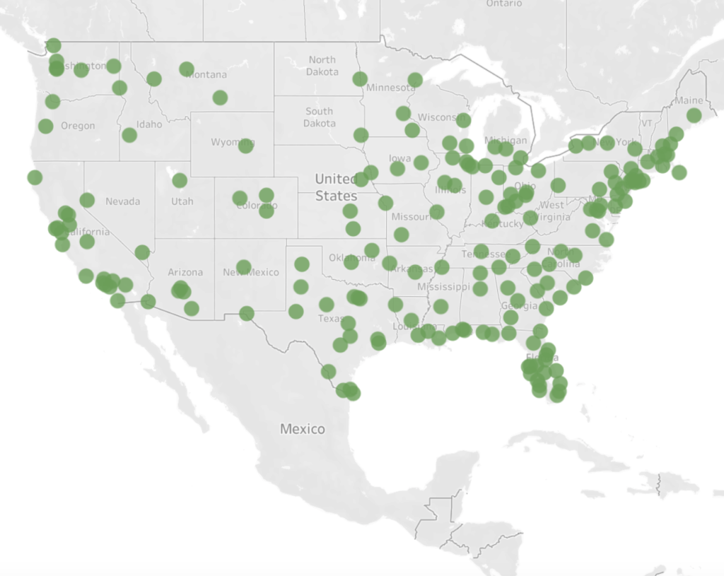
This list of airports is probably going to increase after July 1st, as more 5G towers are installed across the country.

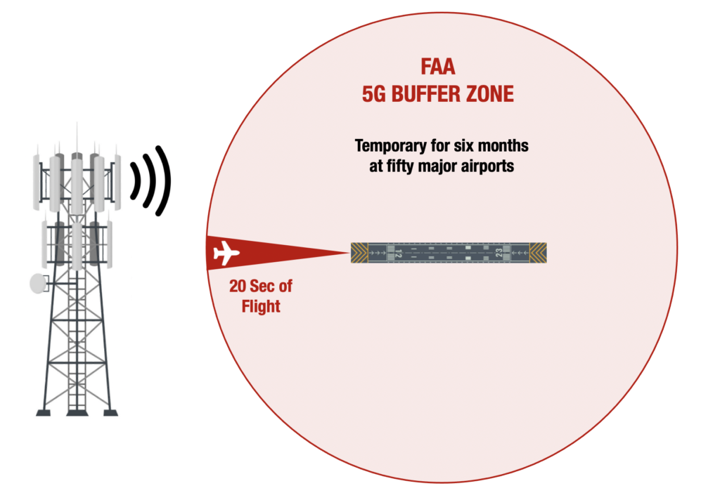
What’s the backstory to all this? Please make it short

In Dec 2021, the FAA had concerns about 5G networks interfering with aircraft radio altimeters due to similar frequencies. They banned fancy landings at some airports, issued some guidelines, and allowed some exemptions. In the end, a deal was made to delay activation near major airports, initially until July 2022 but extended to July 2023.

Where can I find more info?

  • Really, truly, head here first for the FAA rules on all this, to get it from the horse’s mouth.
  • Then if you’re still keen, you can check here for the FAA website on all things 5G.
  • And also here for a recent webinar by AIN on the impact of 5G, with a focus on bizav.
  • Then finally here for the most recent special airworthiness information bulletin issued by the FAA on 24th May 2023, where they’re basically asking manufacturers and operators to continue assessing the whole 5G issue and report back to them their findings.


US: 5G Rollout Near Airports Delayed Until 2023

Six months have passed since the FAA hurriedly reached an agreement with Telecoms AT&T and Verizon to delay switching on powerful new 5G antennas near major airports.

That agreement was set to expire on July 5. And the original concerns haven’t gone away – 5G can still interfere with radio altimeters, and the industry is still scrambling for a fix.  If safety buffer zones were to stop buffering at larger airports, where low visibility landings are more common, the impact would have become even worse.

However, on Friday the FAA released its first update since February – and the news is good…

A new agreement

AT&T and Verizon have agreed to extend the delay until July 2023 to allow the FAA and operators more time to get their ducks in a row.

There is compromise happening on both sides of the deal. While the FAA hasn’t gone into the specifics, they have said there is now a phased rollout plan to make sure that both sides are kept happy.

The FAA will begin work to identify which airports are safe enough for the Telecoms to start enhancing their services there right away, without turning everything on.

On the flip side, there will be more time for operators of aircraft fitted with radio altimeters vulnerable to interference to replace them, or install special filters. Regional aircraft are particularly affected by this.

Considering that the first customers are only just now receiving these filters from the radio altimeter manufacturers, the original goalposts were always fairly ambitious.

A new FAA deadline for operators to complete work on their fleets is set for the end of the year, and this time it looks to be firm. The Telecoms are expecting to be let loose at the end of the new deal.

In the meantime

The status quo – existing restrictions will remain in place. Back in January over a thousand Notams (1,478 to be precise) were issued when 5G hit the proverbial fan. Many of them restrict the use of Autoland, HUD to Touchdown, and Synthetic Vision Systems at specific airports. The FAA has also published a guide that explains the different types of Notams and what those limitations mean for operators at various airports.

The FAA has also since provided a number of exemptions for more common passenger jets to continue with low visibility landings. You can view those through the FAA’s handy map here.

Unfortunately, the support for business jets has not been as forthcoming. If your aircraft doesn’t have an exemption, you’ll have to stick to the Notams, which means paying extra special attention to the weather and alternate planning when it’s looking murky out there.

Buffers will also remain in place at several major airports to make sure that low visibility landings can continue without causing major headaches for operators. You can view that list here.

Other things to look at

If you’d like to know more about the problem with 5G networks and aviation in more detail, we wrote a blog article earlier this year that would be a great place to start.

There’s also the FAA’s official 5G website, where updates like the one above are published.

Get in touch

If you have other questions, we’d be happy to help. You can reach us on news@ops.group.


US 5G Roll Out: Launch Day, More Delays, New Notams and FAA Buffers

**Update, Jan 19 – New**

While most of the 5G network has been switched on, several 5G providers have delayed rolling out services at stations close to the major airports. It isn’t clear how the long the delay is for.

Over the weekend, the US FAA said it had cleared 45 percent of the US commercial aircraft fleet for operation in low-visibility conditions at 48 of the 88 airports directly affected by 5G C-band interference. This latest delay is most likely to allow the FAA to continue confirming the safety consequences at the major airports, after pressure from US and foreign carriers.

**Update, Jan 19**

The big day has arrived for the new 5G networks. They are set to be switched on.

New FAA Notams with operating restrictions at a large number of airports across the US become effective. Make sure you check them for any airport you may be operating at (including alternates) – especially if you are expecting low visibility operations. You may not be able to carry out Cat II/III approaches. You can search for the new Notams here, using the keyword ‘5G.’

Several industry heavy weights have asked the US Government directly to further restrict 5G networks near major airports and the outcome is still pending. Both Verizon and AT&T has reportedly already agreed to limit services near some – more details will follow as they come to hand.

Major international carriers have also begun cancelling or restricting flights to the US until more is known about the safety implications of the new networks.

**Update, Jan 14**

At least 100 airports have Notams banning or restricting operations such as Autolands, HUD usage, or any other manoeuvre reliant on radio altimeters, unless the aircraft is equipped with another means of compliance (with altitude monitoring).

The Autoland ‘ban’ is of significant concern due to its potential impact on safety and efficiency during low visibility and poor weather conditions. This could limit alternate options and result in significant delays and fuel situations if airports are unable to accommodate traffic during these conditions.

Several major airports are impacted including KORD/Chicago, KFDW/Dallas Fort Worth, KIAH/Houston, KJFK/New York, KSEA/Seattle, KBOS/Boston and KLAX/Los Angeles.

The Situation

The US FAA has published a list of fifty major US airports which will have 5G buffers in place to ensure safe operations.

Here’s an update on the latest and what this all means.

Flicking the ‘ON’ Switch

Verizon and AT&T will activate major new 5G networks in the US on January 19. This follows a two-week delay as the industry scrambles to assess just how much of a safety risk this might be to civil aviation.

The Concern

These new 5G services will operate in a frequency band that is uncomfortably close to what radio altimeters use. This could lead to erroneous signals and mess with safety-critical systems – especially auto land and TAWS.

For more details information on these issues, including how you can mitigate them, see our recent article.

How will these ‘buffer zones’ work?

Both Verizon and AT&T have made an agreement with the FAA to turn off transmitters in close proximity to select major airports for a further six months. During this time the FAA will be able to better assess the potential for interference.

These buffer zones will apply within the last twenty seconds of flying time in all directions from the airport.

How did the FAA choose the list?

A number of factors were taken into account. These included traffic volume, how many low visibility days there are each year, and how close the airports were to the new antennas.

Other major airports were not included for various reasons such as those in areas where the networks aren’t being rolled out, ones that are far enough away from the antennas, or  fields with no CAT II/III facilities.

Important US Resources

In recent months the FAA has published a number of important documents for pilots dealing with this looming 5G issue:

….for a detailed breakdown of these, click here.

The US isn’t alone.

There have also been some developments north of the border in Canada, where 5G networks are being progressively rolled out.

On Dec 23, Transport Canada published its own Safety Alert (CASA 2021-08) with some important recommendations for pilots. This was the big one – avoid flying RNP AR approaches that are not protected by buffer zones in IMC conditions, unless you have another way to identify terrain (such as weather radar). This is because the TAWS may not be reliable.

What next?

Industry efforts to understand the safety impact to aviation from these networks are ongoing. That means working directly with airlines and manufacturers, and it will take time. Temporary buffer zones help, but long-term solutions are needed.

But there’s 5G in other countries. Why is this such a big issue in the US?

A few reasons. Signal strengths will be much higher in the US than in other countries’ networks around the world.

Other design features and protections in place for aviation overseas have not been mandated on network providers. These include measures such as tilting antennas down, introducing permanent buffer zones, rules on how close antennas can be to airports and reduced power levels.

Stay Updated

There are two places to stay updated as this all develops. The first is the FAA’s official 5G website found here. The NBAA have also published a handy resource you can access by clicking here.


Is the 5G rollout a new threat to aircraft safety?

The FAA issued a statement on Dec 7 regarding the expansion of 5G networks across the US, and its impact on aviation. It doesn’t sound good – which is something folk have been saying for a while now…

What’s the background?

5G is being rolled out across the US in the form of massive antennas. No issue so far. The problem comes in when they turn them on because they use frequencies which are part of the ‘slice’ of radio spectrum usually reserved for GPS signals. Which means they will probably interfere with those signals, and disrupt the equipment in the aircraft utilising those frequencies.

That equipment concerned are Radio Altimeters which, as we all know, are fairly critical to certain operations. Some big accidents have been attributed to malfunctioning Rad Alts like Turkish Airlines Flight 1951.

Radio Altimeters transmit on frequencies between 4.2GHz and 4.4GHz, while the 5G network will use a C-Band range of 3.7GHz to 3.98GHz.

Why the concern?

The big problem in all of this is the lack of information on how much interference will actually occur.

It is not clear which airports will be impacted or to what degree equipment might be disrupted because it depends on the location and the strength of signals. While the RTCA (Radio Technical Commission for Aeronautics) has conducted measurements and found that high levels of inaccuracy and outright failure of Radio Altimeters can be expected when operated near base stations – many of which are located near major airports – until they are turned on it is hard to know… 

The FAA also suggested that while issues with RAs are the primary problem, it is unknown what else may be impacted so crew are going to have to be extra vigilant of their instruments, and of passengers potentially connecting to 5G networks while airborne because the impacts are just not known.

What has the FAA done?

The FAA has issued two airworthiness directives, one for aircraft and one for helicopters, in an attempt to enable ‘the expansion of 5G and aviation’ to ‘safely co-exist’.

This is in addition to an earlier Special Airworthiness Information Bulletin issued in November 2021 highlighting the Risk of Potential Adverse Effects on Radio Altimeters.

Let’s take a look at the new directive.

The FAA determined that – “at this time, no information has been presented that shows radio altimeters are not susceptible to interference caused by C-Band emissions” and because they don’t know, they have to mitigate against the possibility that they will be.

So, AD 2021-23-12 requires the “revising of the limitations section of the exiting airplane/aircraft flight manual (AFM) to incorporate limitations prohibiting certain operations requiring radio altimeter data when in presence of 5G C-Band interference as identified by NOTAMs.”

In other words, you’re going to need to amend your AFM so it takes into account the possible impact of 5G.

The AFM revision will look something like this –

What’s the impact?

In short – possibly a lot, possibly nothing, and the only way to tell is to check NOTAMs. Start checking them now, because operations using the new spectrum started December 5.

The key word in the revision is ‘interference’ because again, that won’t be entirely known until base stations are switched on and reports received. Which puts operators in a tough spot because those approaches that are prohibited (because of interference) are effectively all your precision approaches and means of landing in reduced weather conditions:

  • ILS CAT I, II, III.
  • RNP (AR) procedures.
  • Automatic Landing.
  • Manual flight control guidance system operations to landing/HUD to touchdown operations.
  • Use of EFVS to touchdown.

Where is the impact?

The US currently has around 279 cities, across 46 states, connected to the 5G network. Of course, it is only the base stations in close proximity to airports which will be operating on the C-band at interfering levels that are a problem. The FAA are currently working with telecoms providers to establish which airports will have C-Band base stations near them.

This shows the anticipated coverage across the USA. The magenta is 5G Ultra Wideband, the bright red is 5G Nationwide, and the pinkish/orangey red is the current 4G LTE coverage.

It could be a worldwide problem

The issue is not necessarily restricted to the US. 5G is growing globally, with China equally far ahead in their implementation of it, which raises concerns of where else this might pose a potential threat.

Thankfully some countries, like Canada, have opted to prevent or restrict services near major airports, at least until further data is received.

What you need to do.

  • As an operator, you will need to ensure your aircraft are compliant with the new directive, so read AD 2021-23-12  and ensure you update your AFM when required.
  • Right now, the biggest thing to do is to check NOTAMs.
    • Base stations are still being activated, and the interference levels due variable power levels and locations means it is not clear where or what the impact will be. NOTAMs will therefore be issued for specific airports confirming the restrictions for them, as and when this is known. And this could change daily.
  • Staying updated on the situation at airports you operate into, as well as encouraging crew to review the weather and alternative approaches in case they become required is critical.
  • Review the function of radio altimeters on your aircraft and understand the implications to capability and performance of malfunctions.

What else can you do?

You can write in and express comments, written data, views and arguments on the directive to the FAA. Ensure you title the correspondence with this – “Docket No. FAA-2021-0953 and Project Identifier AD-2021-01169-T” 

You can Email this feedback to operationalsafety@faa.gov. Alternatively, you can send via Fax: 202-493-2251 or Post: U.S. Department of Transportation, Docket Operations, M-30, West Building Ground Floor, Room W12-140, 1200 New Jersey Avenue SE, Washington, DC 20590.

You can also request further information from Mr Brett Portwood, Continued Operational Safety Technical Advisor, COS Program Management Section, Operational Safety Branch, FAA, 3960 Paramount Boulevard, Lakewood, CA 90712-4137.

Any interference should be reported to the FAA to assist them in building up a better picture of the impact and safety concern.

You can also follow AOPA’s work on 5G as they continue to monitor and ask the FAA to address the situation urgently.


GPS U/S in the US

We have written a fair amount on worldwide GPS Jamming issues. Here is what we said about it in ‘GPS Jamming: All the Wrong Signals’. But there is another GPS problem though which is a little closer to home (if your ‘aviation’ home is in the US anyway).

What’s the deal?

Let’s take a step back to 2017, when the NBAA and a bunch of other stakeholders took part in the 2017 RTCA tactical operation committee. That’s the Radio Technical Commission for Aeronautics and they are great – they try and help find compromises amongst the competing interests on critical aviation modernization issues.

One of these very issues is with GPS.

The FAA’s NextGen modernization program is using more and more GPS ‘stuff’. Stuff that is critical for commercial flight operations safety and efficiency. The US Department of Defense on the other hand is sort of doing the opposite – they are running GPS Jamming tests which are critical for National Security and the big problem with this is that the jamming tests often interfere with the GPS signals civil aircraft are using.

What was the 2017 outcome?

After they talked about it in 2017, the compromise was that the DoD will notify the FAA at least 120 hours before any planned tests. This should give the FAA time or put out Notams to warn crew and operators.

Problem solved?

Unfortunately not. The 120 hours notification is given, but the information which filters down to the pilots and operators who need to know about it often not sufficient. One of the difficulties is that the Notams have to provide information on different outage locations and this means loooooooong Notams filled with lots of Lat and Longs and times and dates. And this means critical information can sometimes get buried inside and makes it difficult or confusing for the crew to find it, extrapolate it (or even be aware of it in the first place).

What’s the plan now?

Well, the NBAA have reported on this, and say that the FAA are taking their concerns onboard. They plan to revisit the idea of producing visual representations of the outage areas. These will be much easier to digest than lines of lat and longs, and would hopefully enable crew to use them in conjunction with planning apps in the future.

There has also been a reminder issued to crew asking them to report outages and issues. If you find yourself in a jammy area, let ATC know. Tell them what you have lost so that they can warn other aircraft in the immediate area. The reminder has been sent to ATC as well because in the past, when aircraft have made these reports, the information has not always been shared out to other operators in the near vicinity.

What do you need to look out for?

What an outage means, practically, is interference to the GPS signals which your navigation system is using. The result can be a degradation in accuracy, or a full loss of the system (GPS primary).

If you are enroute, let ATC know your capability has been degraded so you can get the support you need to continue navigating safely.

Some aircraft are particularly sensitive to disruption in the GPS signals, and it can lead to you losing that system until it is reset on the ground. This means RNAV/RNP approaches might not be flyable anymore. Having an awareness of what this means for your aircraft is important. Think about your plan B for approaches in case you do loose GPS navigation capability.

Notams are out there and it might be frustrating picking out the areas which could impact you, but knowing about the outage spots in advance will help.

Where can you look for info?

The 5G Update

We thought we’d throw in a little update in on this as well.

Last year we saw increasing concerns about possible interference from 5G networks because they operate on the same slice of radio spectrum usually reserved for Radio Altimeter signals (the 3.7-3.98 GHz band).

The big concern here is that interference could result in degradation of accuracy from spurious emissions, or outright failures in the radio altimeters. Not sure how much of a risk that means? Well, Turkish Airlines TK1951 crashed in EHAM/Amsterdam Schiphol in 2009 and one of the primary factors was attributed to a malfunctioning radio altimeter which sent an erroneous -8ft reading to the autothrottle system, commanding it to idle.

The NBAA are fronting a campaign here as well. Twenty organizations have joined forces to send the FAA a letter raising their concerns over this, in response to a report issued on March 3 that they don’t feel addresses the threat with enough analysis.

You can read the letter here.

Military aircraft and UAVs are also at risk here. Their radio altimeters use the same C-band frequencies, but they tend to fly a lot nearer the ground a lot more often. A very good summary of the issue can be found here.