Is the 5G rollout a new threat to aircraft safety?

The FAA issued a statement on Dec 7 regarding the expansion of 5G networks across the US, and its impact on aviation. It doesn’t sound good – which is something folk have been saying for a while now…

What’s the background?

5G is being rolled out across the US in the form of massive antennas. No issue so far. The problem comes in when they turn them on because they use frequencies which are part of the ‘slice’ of radio spectrum usually reserved for GPS signals. Which means they will probably interfere with those signals, and disrupt the equipment in the aircraft utilising those frequencies.

That equipment concerned are Radio Altimeters which, as we all know, are fairly critical to certain operations. Some big accidents have been attributed to malfunctioning Rad Alts like Turkish Airlines Flight 1951.

Radio Altimeters transmit on frequencies between 4.2GHz and 4.4GHz, while the 5G network will use a C-Band range of 3.7GHz to 3.98GHz.

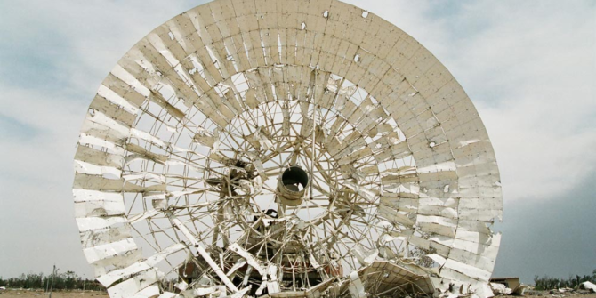
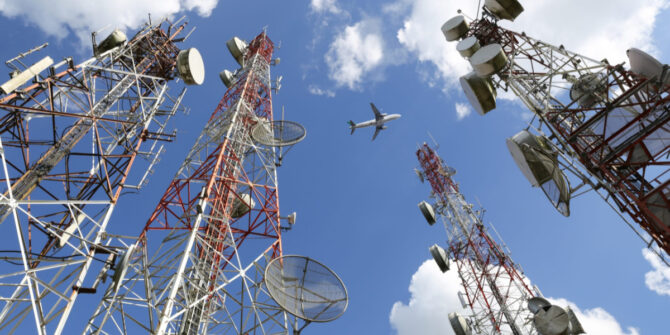
A larger telecommunications base station.

Why the concern?

The big problem in all of this is the lack of information on how much interference will actually occur.

It is not clear which airports will be impacted or to what degree equipment might be disrupted because it depends on the location and the strength of signals. While the RTCA (Radio Technical Commission for Aeronautics) has conducted measurements and found that high levels of inaccuracy and outright failure of Radio Altimeters can be expected when operated near base stations – many of which are located near major airports – until they are turned on it is hard to know… 

The FAA also suggested that while issues with RAs are the primary problem, it is unknown what else may be impacted so crew are going to have to be extra vigilant of their instruments, and of passengers potentially connecting to 5G networks while airborne because the impacts are just not known.

What has the FAA done?

The FAA has issued two airworthiness directives, one for aircraft and one for helicopters, in an attempt to enable ‘the expansion of 5G and aviation’ to ‘safely co-exist’.

This is in addition to an earlier Special Airworthiness Information Bulletin issued in November 2021 highlighting the Risk of Potential Adverse Effects on Radio Altimeters.

Let’s take a look at the new directive.

The FAA determined that – “at this time, no information has been presented that shows radio altimeters are not susceptible to interference caused by C-Band emissions” and because they don’t know, they have to mitigate against the possibility that they will be.

So, AD 2021-23-12 requires the “revising of the limitations section of the exiting airplane/aircraft flight manual (AFM) to incorporate limitations prohibiting certain operations requiring radio altimeter data when in presence of 5G C-Band interference as identified by NOTAMs.”

In other words, you’re going to need to amend your AFM so it takes into account the possible impact of 5G.

The AFM revision will look something like this –

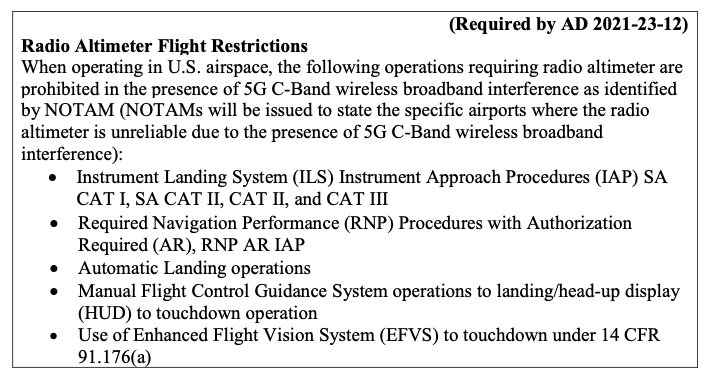
The AFM revision showing RA restrictions

What’s the impact?

In short – possibly a lot, possibly nothing, and the only way to tell is to check NOTAMs. Start checking them now, because operations using the new spectrum started December 5.

The key word in the revision is ‘interference’ because again, that won’t be entirely known until base stations are switched on and reports received. Which puts operators in a tough spot because those approaches that are prohibited (because of interference) are effectively all your precision approaches and means of landing in reduced weather conditions:

  • ILS CAT I, II, III.
  • RNP (AR) procedures.
  • Automatic Landing.
  • Manual flight control guidance system operations to landing/HUD to touchdown operations.
  • Use of EFVS to touchdown.

Where is the impact?

The US currently has around 279 cities, across 46 states, connected to the 5G network. Of course, it is only the base stations in close proximity to airports which will be operating on the C-band at interfering levels that are a problem. The FAA are currently working with telecoms providers to establish which airports will have C-Band base stations near them.

This shows the anticipated coverage across the USA. The magenta is 5G Ultra Wideband, the bright red is 5G Nationwide, and the pinkish/orangey red is the current 4G LTE coverage.
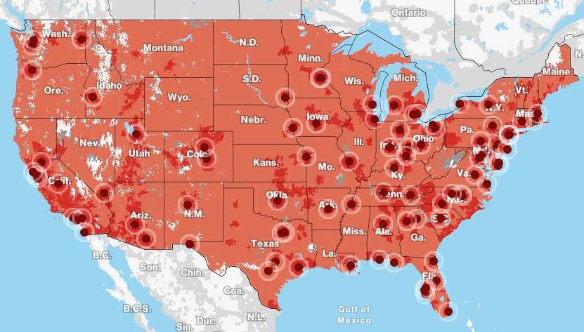
Map of 5G coverage

It could be a worldwide problem

The issue is not necessarily restricted to the US. 5G is growing globally, with China equally far ahead in their implementation of it, which raises concerns of where else this might pose a potential threat.

Thankfully some countries, like Canada, have opted to prevent or restrict services near major airports, at least until further data is received.

What you need to do.

  • As an operator, you will need to ensure your aircraft are compliant with the new directive, so read AD 2021-23-12  and ensure you update your AFM when required.
  • Right now, the biggest thing to do is to check NOTAMs.
    • Base stations are still being activated, and the interference levels due variable power levels and locations means it is not clear where or what the impact will be. NOTAMs will therefore be issued for specific airports confirming the restrictions for them, as and when this is known. And this could change daily.
  • Staying updated on the situation at airports you operate into, as well as encouraging crew to review the weather and alternative approaches in case they become required is critical.
  • Review the function of radio altimeters on your aircraft and understand the implications to capability and performance of malfunctions.

What else can you do?

You can write in and express comments, written data, views and arguments on the directive to the FAA. Ensure you title the correspondence with this – “Docket No. FAA-2021-0953 and Project Identifier AD-2021-01169-T” 

You can Email this feedback to operationalsafety@faa.gov. Alternatively, you can send via Fax: 202-493-2251 or Post: U.S. Department of Transportation, Docket Operations, M-30, West Building Ground Floor, Room W12-140, 1200 New Jersey Avenue SE, Washington, DC 20590.

You can also request further information from Mr Brett Portwood, Continued Operational Safety Technical Advisor, COS Program Management Section, Operational Safety Branch, FAA, 3960 Paramount Boulevard, Lakewood, CA 90712-4137.

Any interference should be reported to the FAA to assist them in building up a better picture of the impact and safety concern.

You can also follow AOPA’s work on 5G as they continue to monitor and ask the FAA to address the situation urgently.


GPS U/S in the US

We have written a fair amount on worldwide GPS Jamming issues. Here is what we said about it in ‘GPS Jamming: All the Wrong Signals’. But there is another GPS problem though which is a little closer to home (if your ‘aviation’ home is in the US anyway).

What’s the deal?

Let’s take a step back to 2017, when the NBAA and a bunch of other stakeholders took part in the 2017 RTCA tactical operation committee. That’s the Radio Technical Commission for Aeronautics and they are great – they try and help find compromises amongst the competing interests on critical aviation modernization issues.

One of these very issues is with GPS.

The FAA’s NextGen modernization program is using more and more GPS ‘stuff’. Stuff that is critical for commercial flight operations safety and efficiency. The US Department of Defense on the other hand is sort of doing the opposite – they are running GPS Jamming tests which are critical for National Security and the big problem with this is that the jamming tests often interfere with the GPS signals civil aircraft are using.

What was the 2017 outcome?

After they talked about it in 2017, the compromise was that the DoD will notify the FAA at least 120 hours before any planned tests. This should give the FAA time or put out Notams to warn crew and operators.

Problem solved?

Unfortunately not. The 120 hours notification is given, but the information which filters down to the pilots and operators who need to know about it often not sufficient. One of the difficulties is that the Notams have to provide information on different outage locations and this means loooooooong Notams filled with lots of Lat and Longs and times and dates. And this means critical information can sometimes get buried inside and makes it difficult or confusing for the crew to find it, extrapolate it (or even be aware of it in the first place).

What’s the plan now?

Well, the NBAA have reported on this, and say that the FAA are taking their concerns onboard. They plan to revisit the idea of producing visual representations of the outage areas. These will be much easier to digest than lines of lat and longs, and would hopefully enable crew to use them in conjunction with planning apps in the future.

There has also been a reminder issued to crew asking them to report outages and issues. If you find yourself in a jammy area, let ATC know. Tell them what you have lost so that they can warn other aircraft in the immediate area. The reminder has been sent to ATC as well because in the past, when aircraft have made these reports, the information has not always been shared out to other operators in the near vicinity.

What do you need to look out for?

What an outage means, practically, is interference to the GPS signals which your navigation system is using. The result can be a degradation in accuracy, or a full loss of the system (GPS primary).

If you are enroute, let ATC know your capability has been degraded so you can get the support you need to continue navigating safely.

Some aircraft are particularly sensitive to disruption in the GPS signals, and it can lead to you losing that system until it is reset on the ground. This means RNAV/RNP approaches might not be flyable anymore. Having an awareness of what this means for your aircraft is important. Think about your plan B for approaches in case you do loose GPS navigation capability.

Notams are out there and it might be frustrating picking out the areas which could impact you, but knowing about the outage spots in advance will help.

Where can you look for info?

The 5G Update

We thought we’d throw in a little update in on this as well.

Last year we saw increasing concerns about possible interference from 5G networks because they operate on the same slice of radio spectrum usually reserved for Radio Altimeter signals (the 3.7-3.98 GHz band).

The big concern here is that interference could result in degradation of accuracy from spurious emissions, or outright failures in the radio altimeters. Not sure how much of a risk that means? Well, Turkish Airlines TK1951 crashed in EHAM/Amsterdam Schiphol in 2009 and one of the primary factors was attributed to a malfunctioning radio altimeter which sent an erroneous -8ft reading to the autothrottle system, commanding it to idle.

The NBAA are fronting a campaign here as well. Twenty organizations have joined forces to send the FAA a letter raising their concerns over this, in response to a report issued on March 3 that they don’t feel addresses the threat with enough analysis.

You can read the letter here.

Military aircraft and UAVs are also at risk here. Their radio altimeters use the same C-band frequencies, but they tend to fly a lot nearer the ground a lot more often. A very good summary of the issue can be found here.


Bomb Onboard: Do you know your procedures?

Airport security means the threat of a bomb onboard is greatly reduced. But if you do receive a bomb threat, or find a suspicious package onboard, what procedure does your operator have in place for you to follow?

How much risk is there?

You have probably all heard the Shoe Bomber attempt from 2001. This was thwarted by some brave passengers and crew, and also the fact the bomber had sweaty feet – his swamp foot dampened the trigger preventing it from igniting.

In 2016, an aircraft made an emergency at HCMM/Mogadishu airport after a bomb exploded onboard. The bomb was likely brought on concealed within a laptop. This flight was lucky though – the impact of the bomb was minimal, limited because the bomb exploded while the aircraft was at a lower altitude (11,000ft).

In 2020 a European airline found a ‘bomb note’ onboard. The flight was escorted to a safe landing and passengers disembarked without incident.

So bomb threats, and attempted bombings, do occur, and while security is getting better and better, unfortunately terrorists are getting more creative in finding ways to bring items on board. The attempts are not always aimed at causing destruction either – threats alone cause a huge amount of disruption to operations. So understanding how to assess the risk and credibility of a threat is as important as knowing how to deal with a possible explosive device if one is found onboard.

Is the threat credible?

Threats received regarding an aircraft need to be assessed, and the credibility determined. The threat classification will generally be based around how specific the threat is. Most operators will have a procedure in place for determining this, and probably take into account something along the following lines:

If a threat mentions a specific target, or is made by a known terrorist organization and is deemed credible then this is going to be considered more serious. Often these are referred to as a red threat.

On the other hand, a threat which is vague, general, and doesn’t specify targets might be considered less credible. A hand scribbled note in the toilet for example. This would be categorized as a green threat.

However, regardless of the assessed credibility, a bomb threat has to be taken seriously and treated as a genuine situation.

If you are on the ground

The simplest and safest option if you are on the ground is to disembark and carry out a full search of the aircraft. It might be a hassle and result in some big delays, but the possible alternative is much worse.

A serious threat may require a precautionary disembarkation – which will result in offloading the passengers as quickly and as safely as possible. This creates a risk to safety in itself, and generally the credibility of the threat will be communicated to the crew so that they can judge the risk of waiting (for steps) versus disembarking immediately to clear the aircraft (but have passengers hurling themselves towards the tarmac).

If you are in flight

If a threat is received against your aircraft while in flight, carry out a search checking those places which are often overlooked during security checks on the ground, but where an article might easily be concealed – toilets, galleys, jump seats, stowage areas, closets etc. Try and do it discreetly to avoid unnecessary worry for passengers.

If an article is found, do not move it or touch it. Move passengers away from the immediate area, and remove any flammable items and have fire extinguishers ready in case. A PA asking for anyone onboard with ‘BD or EOD experience’ might help – these are terms which experts will recognize without saying “Hey, passengers, is there a bomb expert onboard?”

Not terrifying your passengers is probably a good call, but ensuring they are following your crew’s orders, and that they are prepared for the situation on the ground, is also necessary. This means providing them with clear information, but without dramatizing the situation.

“Ladies and Gentlemen, we have received a message that a threat has been made against one of our aircraft/an aircraft in this airspace. These threats do happen, however, until we can establish how credible it is, we will take all possible precautions and therefore intend to land at… in…”

If you find a suspicious article

Most manufacturers provide checklists for bomb-on-board situations. Know where this is, and understand what it says. 

There are a few measures you might want to consider:

  • Talk to ATC so they know exactly what is going on and what you need. They all assist with locating an airport with services needed, and coordinating with military if necessary.
  • Try to avoid routes over heavily populated areas.
  • Consider carefully the choice between flying fast to minimize airborne time versus flying slow to minimize air-loads and damage (in the event of fuselage rupture).
  • Request remote parking on the ground if there isn’t a designated bomb location.
  • Brief your crew for a possible emergency landing, and in any event, brief them to ensure passengers are disembarked quickly and moved to at least 200m upwind from the aircraft.
  • Avoid large and rapid changes to pressure altitude – consider using manual cabin altitude controls to minimize rapid pressure changes while still lowering the cabin altitude to reduce the differential pressure.

Aircraft are designed to not ‘explode’ if there is a rupture in the fuselage – that’s why they tend to have a lot of smaller sections attached together. It makes the overall structure more resilient to the effects of an explosive decompression, aiming to keep it “localized”.

Reducing the differential pressure to around 1 PSI will also reduce the damage if an explosion does occur. Maintaining a slight differential will ensure the blast moves outwards, but the lower differential limits the force of air from the cabin outwards. 

1psi is the equivalent of about 2,500 feet difference, but flying at an altitude that allows you to manually reduce the differential will probably mean a much lower level and much higher fuel burn.

Where is your aircraft’s LRBL?

A Least Risk Bomb Location is an area where the least damage will occur should a bomb explode. This should be specified in your aircraft manual. These are often near aft doors or in washroom stowage areas. The area provides the least risk, in the event of an explosion, to flight critical structures and systems.

If the article is deemed unsafe to move, cover it in plastic to prevent any liquids getting in, and then pile blankets and pillows, seat cushions and soft clothing around it. We’re talking as big a pile as you can, and once done, saturate in water to minimize fire risk in case an explosion does occur. Don’t forget the plastic sheets first though –  liquid damage to electrical components is also a big risk.

If you can move it, and only if it is deemed essential to do so, then check that LRBL. Once in place, build up the barricade.

Always minimize movement to any article as much as possible, and don’t put anything directly on top of it. An igloo of saturated cushions around it and the gaps stuffed with blankets etc is good.  This ‘cushioning’ will help minimize the force if an explosion does occur. Never put inside an oven or trolley though as a sealed container will amplify the pressure and explosive force of a bomb.

Where to go

You will likely be accompanied by fighter jets to an airport with a designated bomb area – usually a remote apron away from buildings, fuel supplies and other aircraft.

What next?

Getting your aircraft safely on the ground is Step One. Getting your aircraft to a safe point to disembark/evacuate your passengers and crew is Step Two and coordinating this with ATC and airport services is important. Knowing in advance where you will taxi to will get you there more quickly and safely. Landing, slamming on brakes and bursting tires will get you nowhere fast, so plan ahead and be prepared.

A bomb threat or bomb onboard situation is difficult to plan for because the ‘where you are and what will happen’ is not something we can prepare for, other than being ready to follow our procedures and remaining calm. Chances are this is not a situation many of us will (thankfully) find ourselves in, but understanding the resources you have to assist, and knowing the onboard procedures so you can coordinate passengers and crew will no doubt help if it ever does occur.