Volcanoes, Ash and Better Forecasts: Meet QVA

Volcanic ash has always been one of aviation’s most frustrating hazards. It is invisible to most onboard radar systems. It can cause engines to surge or flame out, and it can force huge reroutes with very little notice. Until now, forecast products have mostly shown where ash exists rather than how much of it is actually in the air. That is about to change.

The UK Met Office and Météo France are introducing a new type of volcanic ash forecast called Quantitative Volcanic Ash, or QVA. From 27 November 2025, QVA becomes an official ICAO product, with London and Toulouse the first VAACs to provide it operationally. More VAACs around the world are expected to join over the following year as the service is rolled out globally.

What QVA Is and Why It Matters

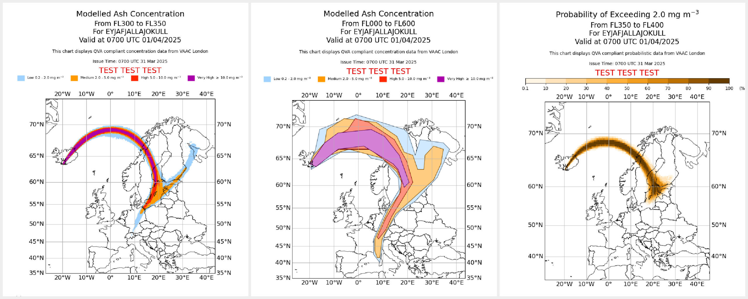
QVA gives you real ash concentration values at different flight levels. Instead of large shaded areas that simply show where ash might be, you get a detailed 3D picture of how much ash is expected in each place and at each time. This lets operators compare forecast ash directly with engine exposure limits rather than working with broad warning zones.

QVA also shows how confident the model is. Low uncertainty means you can keep margins tighter around an ash plume. High uncertainty means planning extra room into the route. It is a smarter and more practical way to think about volcanic ash when planning flights.

The forecasts have a much higher resolution than before. VAAC London says that one forecast used to take about an hour to produce. With QVA they can now generate around 150 ash fields in the same time. You get more detail and you get it faster, which is a big advantage in busy regions like the North Atlantic.

If the data is of interest to your organisation, a request can be made to VAAC London for access to their free QVA API. Just email QVA@metoffice.gov.uk with details of your organisational requirements for volcanic ash data across the north-eastern corner of the North Atlantic, including Iceland and the UK.

The API provides ash concentration and probability forecasts up to FL600 in 3-hourly time steps out to 24 hours, with new forecast runs issued at least every six hours while a significant ash cloud is a hazard. For more details you can visit the Met Office page, and you can also find additional QVA info from VAAC Toulouse.

In short, QVA looks like a real upgrade. Instead of staying far away from anything that resembles a volcano, we can finally make smarter and more precise decisions. Low concentration with low uncertainty may keep a flight close to its ideal track. High concentration with high uncertainty is your clear cue to reroute.

Ash will always be ash, but at least now we can be a bit clever about how we deal with it. We are curious to hear what you think, so we would love to hear from you at team@ops.group.

Volcanoes of the World: The Misery Tour

The last few years have given us a colourful mix of eruptions, each creating its own special brand of trouble for aviation. Here are a few highlights from our unofficial misery tour, in order from oldest to newest.

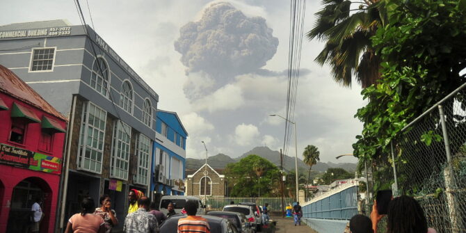
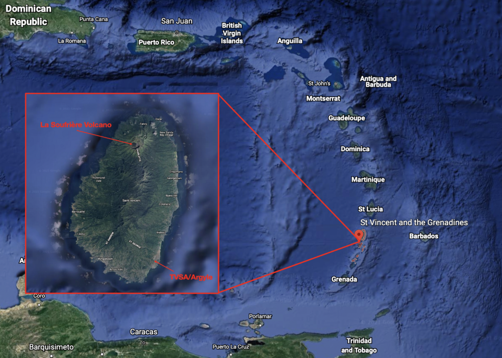
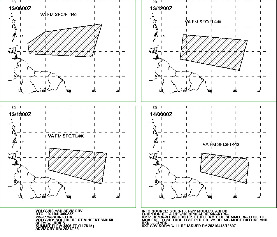
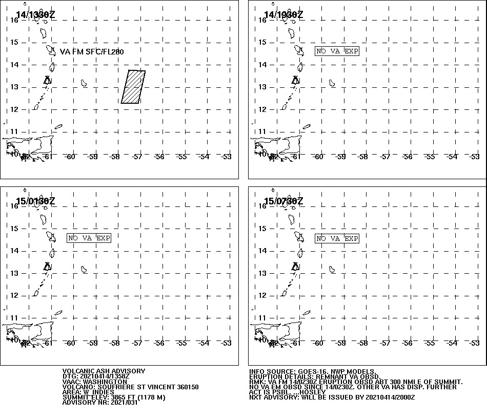
La Soufriere, St Vincent, 2021

A run of explosive eruptions blasted ash up to about 40,000 ft and spread thick clouds across the Caribbean. Airports closed with little warning and alternates quickly filled up as crews diverted around the ash.

Most affected airports: TVSV/St Vincent, TBPB/Barbados, TGPY/Grenada, TAPA/Antigua

Hunga Tonga, Tonga: 2022

This underwater volcano delivered one of the biggest bangs ever recorded. The shockwave circled the planet, ash shot well above cruise levels and satellite links struggled under the pressure. Flights across the South Pacific had to reroute or delay until conditions improved.

Most affected airports: NFTF/Fua’amotu, NFFN/Nadi, NWWW/Noumea, YSSY/Sydney, NZAA/Auckland

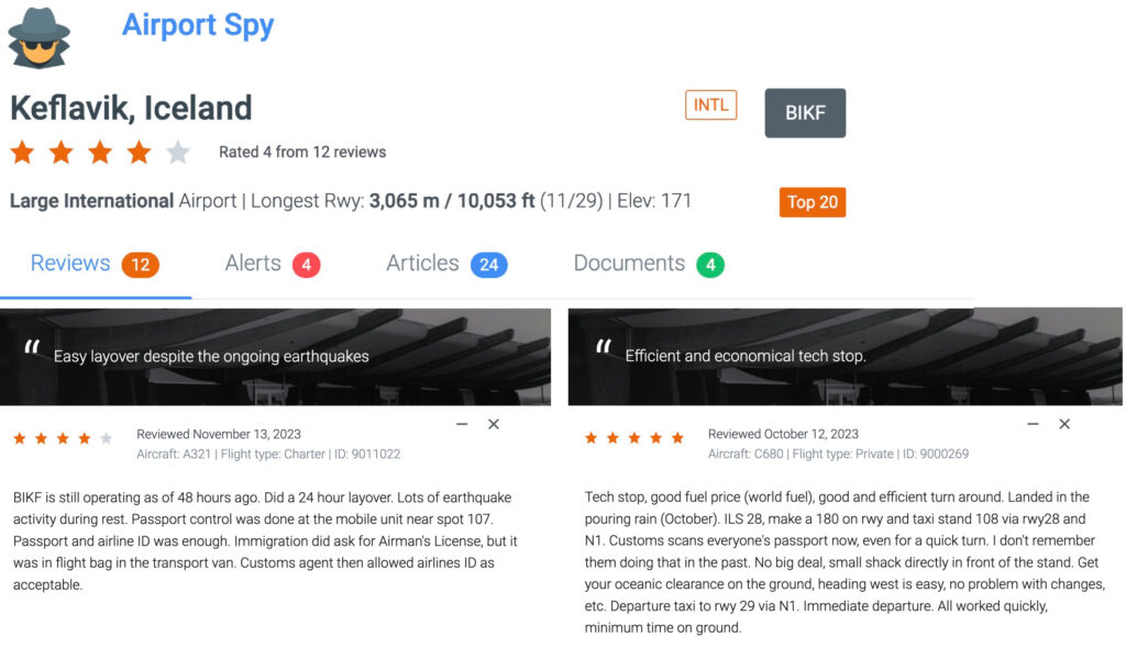
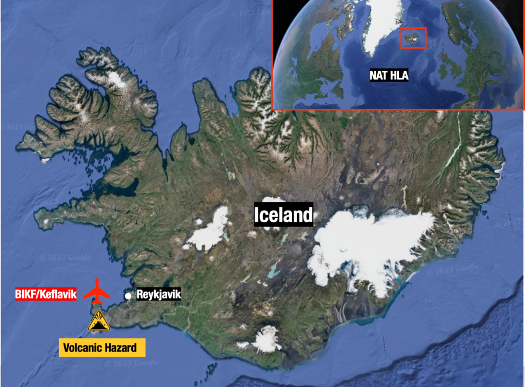
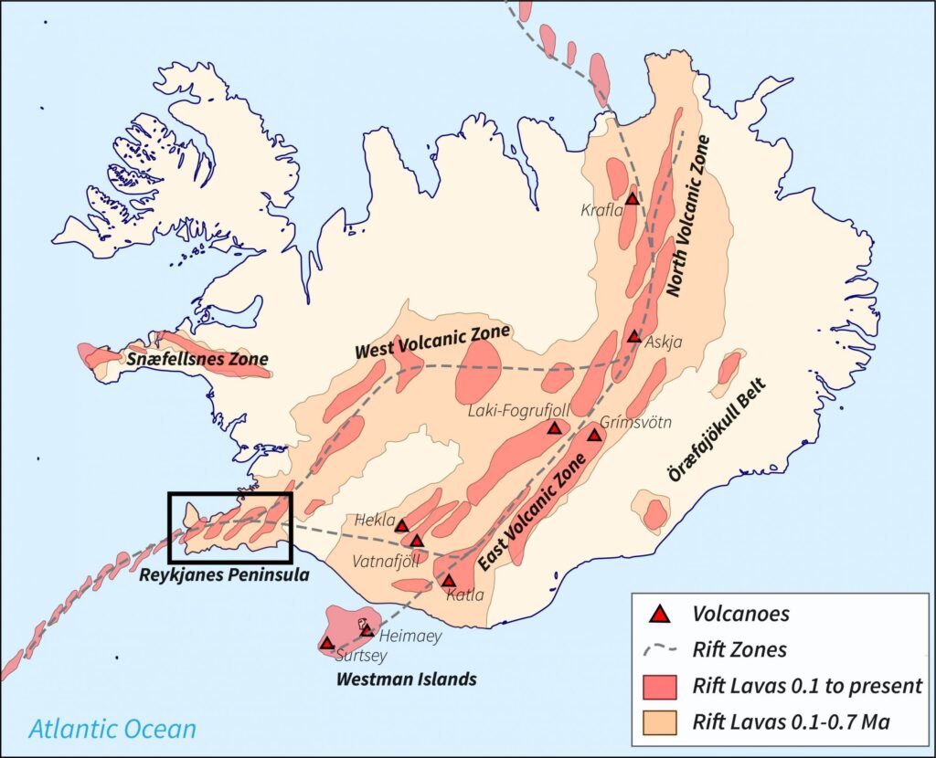
Icelandic volcanoes: 2023-2025

Activity around Fagradalsfjall and the Reykjanes Peninsula caused periodic airport disruptions and NAT flow adjustments. Nothing like 2010, but enough to keep everyone alert.

Most affected airports: BIKF/Keflavik, BIRK/Reykjavik, EGLL/Heathrow, EGKK/Gatwick

Etna and Stromboli, Italy: ongoing

Their eruptions are usually smaller but still a regular headache. Etna can reach flight levels and Stromboli occasionally pushes ash into southern Italian airspace.

Most affected airports: LICC/Catania, LICJ/Palermo

Sangay, Ecuador and Popocatepetl, Mexico: ongoing

Both erupt frequently and love throwing ash across busy Central and South American airways. Dispatchers in the region see SIGMETs from these two on a regular basis.

Most affected airports: SECU/Cuenca, SEQM/New Quito, MMMX/Mexico City, MMPN/Uruapan, MMTO/Toluca.

How Dispatchers and Pilots Actually Work With Volcanic Ash

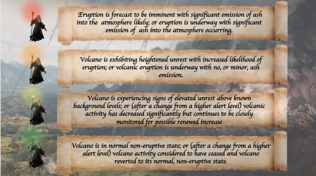
When volcanic ash shows up, dispatchers start with the big picture. The VAAC advisory outlines where the eruption is, how high the ash is being thrown and how the cloud is expected to drift over time.

For actual flight planning though, SIGMETs do most of the heavy lifting. They are the operationally binding piece because they identify where ash is present or expected within the FIRs you are about to cross and at which flight levels. If a SIGMET says ash is sitting between FL200 and FL350 along your route, that plan is getting a makeover. ASHTAMs then step in to describe the major operational impacts such as airport closures or significant service limitations caused by ash.

The routine is simple: check the VAAC to understand the overall structure of the cloud, check the SIGMETs to see what actually matters to your airspace and altitude, and then draw a route that stays sensible without being overly conservative. QVA will slide into this workflow neatly because it finally shows how much ash is out there and how confident the forecast is, which makes the whole decision process a lot more grown-up.

Ash is still ash, but at least now everyone can know exactly how worried to be.

What about you?

When you plan routes in areas affected by volcanic ash, what do you rely on most? Do you start with the VAAC advisories, or do SIGMETs and ASHTAMs carry more weight for you? How do you bring all these pieces together when deciding whether to reroute, change levels or continue as planned?

We would also love to know which tools, charts or sources you find the most useful in real ash events. Let us know at team@ops.group!


North Atlantic Volcanic Threat

Key Points
  • One of Iceland’s volcanoes (10nm southwest of BIKF/Keflavik) is showing signs it’s about to erupt.
  • If it does, NAT crossing traffic is likely to be affected at short notice.
  • ICAO have a Contingency Plan ready to go if it does erupt (PDF below).
  • Pilots and Operators: There is a list of things to watch out for if you do fly through volcanic ash, and a recommended procedure to follow.

Iceland is on high alert for an imminent eruption at one of the volcanoes on the Reykjanes Peninsula – a stone’s throw southwest of Keflavik. If it does erupt, it has potential to seriously impact North Atlantic traffic.

The last time this happened in 2010, the (try pronouncing this one) Eyjafjallajökull volcano closed almost every country’s airspace in Western Europe in the weeks that followed. Nearly 100,000 commercial flights were grounded.

Where are we talking about?

What happens if it erupts?

So far, it’s just a warning. But it’s credible enough for Iceland to declare a state of emergency. Recent earthquakes in the area are an ominous sign. If it does erupt, there are several possible scenarios that could affect air traffic.

  • BIKF/Keflavik may close. Unlike previous eruptions, this one is just 10nm away from the airport and a little further from the Icelandic capital, Reykjavik. Aside from being a major airport in its own right, BIKF is a commonly used ETOPS/EDTO alternate for traffic crossing the NAT.
  • Part of the NAT HLA may become unusable depending on the spread of ash. More southerly routes than usual may become a requirement which means extended flight times and more fuel.
  • Major airspace closures could occur for an extended period of time.  The European mainland may once again be in the firing line, thanks to the mid-latitude westerlies.

Yeah but what ACTUALLY happens?

If the volcano warning goes to code RED (it’s currently code ORANGE), that basically means an eruption has started. In this case, the airspace within a 120nm radius will close, until they confirm there’s no ash cloud. They currently think there is a 15km long line where magma is flowing and moving towards the surface – an eruption could happen anywhere close to that line.

120nm of closed airspace around BIKF/Keflavik airport (remember, the volcano is just up the road) would look something like this:

There’s also a thing called the Volcanic Ash Contingency Plan that ICAO put together. This doc is the one you want to read – there are a few more scattered around online, but they’re all older versions of this one.

This doc sprang from the misery caused by the eruption in 2010, and aims to set out what actually happens if a big volcano erupts.

Essentially, it goes like this:

  1. Volcano erupts. There’s ash all over the place.
  2. Volcanic ash people issue a volcanic ash warning.
  3. Notam people issue a Notam.
  4. Pilots/Operators read the Notam and don’t fly into the ash. ATC help them.

What should I do if I fly through ash?

Don’t fly through ash.

But if you do, then do this:

  1. Reduce thrust.
  2. Do a 180 degree turnback.
  3. Put masks on.
  4. Declare MAYDAY.
  5. Panic a bit as you do whatever emergency tasks you need to do.
  6. Divert somewhere pronto.

Or as it says in more official language in the Contingency Plan:

If I do fly through ash, how scary will it be?

Very scary. Don’t do it. Here’s a list of nightmarish things that will probably happen if you do:

  1. Smoke, fumes or dust may appear in the cockpit. Get those masks on.
  2. Engine malfunctions, stalls, over-temperature, thrust loss, engine failure.
  3. Reduced visibility due to the abrasive effects of ash on windshields and landing lights.
  4. Pitot tubes may become blocked, so airspeed indications may become unreliable.

Advice: disconnect the autopilot, set engine thrust to an appropriate value and maintain the aircraft’s pitch attitude manually. This will keep the aircraft at a safe speed, but will probably result in difficulty to maintain the assigned altitude. Increased separation is required (above and below).

Advisories and Warnings

The London Volcanic Ash Advisory Center (VAAC) is responsible for issuing any ash advisories for this region. You can access those here.

The current alert level is Orange. Verbatim, this means that the volcano is ‘exhibiting heightened unrest with increased likelihood of eruption; or that an eruption is underway with minor ash emission…’ Or in other words, it may be about to erupt.

If you’re not familiar with the volcanic alert scale, here’s how it works:

All traffic crossing the NAT or operating over Western Europe right now should be keeping a close eye on this one.

What’s the latest at BIKF/Keflavik Airport?

We’ve had a couple of reports from members who have been through there recently. If you’ve got anything to add, please file a report at Airport Spy! For info from the airport, you can contact the local handlers at jetcenter@icelandair.is or ops@southair.is.


Eruption in the Caribbean: The La Soufrière Volcano

A tiny island in the Southern Caribbean has made headlines this week after a volcano, dormant for decades, suddenly erupted on Friday almost without warning. It ejected ash as high as FL440.

The La Soufrière volcano is found on the main island of Saint Vincent and the Grenadines, a small country nestled amongst the southeast Windward Islands of the Lesser Antilles. It is neighbours with Saint Lucia to the north, Barbados to the east and Grenada to the South.

The volcano first made headlines on Thursday when scientists detected large seismic tremors – an ominous sign that the La Soufrière volcano was stirring. It had last erupted back in 1979.

Evacuations began for people living near the volcano which is found only 10nm north of the country’s main airport, TVSA/Argyle. Scientists believed an eruption was imminent.

Then on Friday La Soufrière literally exploded back to life with several violent eruptions producing massive amounts of ash. Since then, sporadic eruptions have continued. The latest was on Monday, and scientists believe there is no end in sight. It may continue to erupt (and produce ash) for weeks.

What’s the current operational impact?

The initial VAAC advisories indicated a large ash cloud extending up to FL440 and moving in an easterly direction away from land and into the Central Atlantic:

However, the most recent VAAC Advisory, dated 1358z on April 14, only shows a small area still affected by volcanic ash up to FL280, forecast to dissipate by 1930z:

Two main airports have been shut down by the eruption:

TVSA/Argyle has been closed until further notice having been coated in thick ash. TVSA Notam A0591/21 has that info and is due to expire at 00z on April 15 however it is very likely to be extended.

Further east, winds carried ash toward Barbados closing down TBPB/Bridgetown. It is due to reopen at 1600z on April 16, but further disruptions are possible (TBPB Notam A0585/21 refers).

Outlook

The La Soufrière Volcano remains at Aviation Colour Code Red, meaning a major eruption is underway with significant ash emissions.

The amount of ash it produces depends on the strength of each eruption which is difficult to predict. So far they have been many and varied.

Airports in neighbouring Saint Lucia and Grenada have remained open but may be impacted by further eruptions depending on prevailing winds. Disruptions and closures are possible throughout the South-Eastern Caribbean.

Scientists have seen no sign that the volcano is slowing down and it appears to be following the same patterns as previous eruptions that lasted for extended periods of time – so things may get worse before they get better.

More info

  • You can view the latest VAAC advisories for La Soufrière here.
  • For the dangers of flying in volcanic ash along with operational advice, see our recent article here.