Rules revised: SAFA Ramp Checks for ‘Suspect Aircraft’

01JUN: EASA have published new guidelines for inspectors to assess which aircraft should be prioritised for SAFA ramp checks in Europe and SAFA compliant states. ARO.RAMP.100(b) in the Part-ARO contains the updated list of aircraft that will be selected for priority checking:

(a) (when EASA receive) information regarding poor maintenance of, or obvious damage or defects to an aircraft;

(b) reports that an aircraft has performed abnormal manoeuvres that give rise to serious safety concerns in the airspace of a Member State;

(c) a previous ramp inspection that has revealed deficiencies indicating that the aircraft does not comply with the applicable requirements and where the competent authority suspects that these deficiencies have not been corrected;

(d) previous lists, referred to in ARO.RAMP.105, indicating that the operator or the State of the operator has been suspected of non-compliance;

(e) evidence that the State in which an aircraft is registered is not exercising proper safety oversight; or

(f) concerns about the operator of the aircraft that have arisen from occurrence reporting information and non-compliance recorded in a ramp inspection report on any other aircraft used by that operator;

(g) information received from EASA Third-Country Operator (TCO) monitoring activities;

(h) any relevant information collected pursuant to ARO.RAMP.110. (“whistleblowers”)


The revised Part-ARO, issued in May 2016, contains a large number of revisions and operators should take a close look at the changes.

For a general guide to SAFA Ramp Checks, have a look at our other article: Avoiding the Pain of a Ramp Check.

References:


Australia: GPS requirements relaxed

The implementation day for Australia switching off Navaids remains the same: 26MAY2016, but the GPS requirements are relaxed – a little – especially for foreign private operators.

If you’re Australia based:

  • You’ll have seen this coming and will already be RNP1/2 compliant. CASA has no exceptions.


If you’re a Foreign Operator and have RNP1/2:

  • After 26MAY2016, if you’re RNP1/2 compliant, put it in the Flight Plan (read on), and that’s about it.


If you’re a Foreign Operator and you don’t have RNP1/2:

  • Australia has a Two Year Transition for Foreign Operators after 26MAY
  • An “Acceptable Means of Compliance” is contained in CASA EX06/16
  • Notify CASA in advance using Form “Notification to operate aircraft on RNP 2 routes and/or RNP 1 procedures using GNSS based RNAV 1 & RNAV 2”
  • If you are a non-commercial operator – ie. operating a Private flight, then compliance is not mandatory. According to CASA, through a release to IBAC, “Only commercial operators that can comply with the requirements and want RNP 1 and RNP 2 traffic services are required to apply for an exemption. “


Flight Planning:

  • If you have RNP2 – put GRZ in Field 10a and NAV/RNP2 in Field 18.
  • If you don’t, then you must operate according to Australia’s “Acceptable Means of Compliance” and put RMK/CASA RNP AMC in Field 18.
  • If you don’t, and you’re a private operator, probably worth a RMK/NEG RNP PVT FLT or similar.
  • Keep an eye on the charts – a bunch of new 5 letter waypoints are coming, to replace the VOR’s and NDB’s being switched off.

Reference:


Oceanic Errors

Unfortunately, we don’t fly with three in the cockpit anymore – or even four. The navigators job falls squarely onto the front two seats. Over one weekend in April there was one Gross Navigation Error, and two close calls reported on the North Atlantic.

April 22nd (Friday)
Democratic Republic of the Congo Boeing 727 100 (9QCDC/DRC001) from Santa Maria Island, Azores (LPAZ) to St. John’s NL (CYYT)
At 1235Z, Observed on radar to be over position 4720N 4745W, which was approximately 60 miles north of the cleared route 45N 45W – 47N 50W. The crew reported correctly while in oceanic airspace. The flight was cleared direct to YYT and landed without incident at CYYT. There was no traffic, and no other impact to operations.

April 24th (Sunday)
Neos Airline Boeing 767-300 (INDDL/NOS730) from Ferno, Italy (LIMC) to Havana, Cuba (MUHA)
Cleared via 49N030W 48N040W 45N050W. At 30W, the flight reported 48N040W 44N050W. The aircraft recleared to 45N050W prior to proceeding off course.

Apr 25th (Monday)
Transportes Aereos Portugueses Airbus A330-202 (CSTOO/TAP203) from Lisbon, Portugal (LPPT) to Newark, NJ (KEWR)
Cleared 46N030W 46N040W 45N050W. The aircraft reported proceeding via 46N030W 46N040W 44N050W, as per the original flight plan. The aircraft was recleared via 45N050W prior to proceeding off course.

Did you notice how hard it was to find the error in the above two examples?


Gross Navigation Errors are a really interesting topic, and relevant not just on the North Atlantic but in any Oceanic or Remote airspace where ATC cannot monitor the aircraft tracking.

What defines a GNE? Normally, 25nm: That is, when on “own navigation” the aircraft departs the cleared route by more than 25nm. The NAT Central Monitoring Agency (CMA) now defines a Gross Navigation Error as 10nm instead of 25nm.

Annually, the biggest offenders in order of “market share” are: 1. Corporate/Private, 2. Military/State 3. Civil airlines.

How to Avoid a GNE?
(aka How to avoid a Nastygram from the Authorities):

In general, when operating outside of ATC Radar coverage in any airspace:

  • Crews: Don’t have more than one paper copy of the Flight Plan in the cockpit. Mark the active one “Master Document”. Hide any other copies where you won’t find them.
  • Ops: If you send a new Flight Plan to the crew, tell them what the changes are – especially if you’ve filed a different route in Oceanic or Remote Airspace.
  • Fly the Clearance, not the Filed Plan. This is the biggest gotcha. As soon as you reach the Oceanic Entry Point, or leave radar airspace – refer only to the most recent Clearance from ATC. The filed plan is a request only – sounds obvious, but most GNE’s occur because the crew fly the filed plan although there was a reroute.
  • Be aware of the ‘ARINC424 problem’: In the aircraft FMS, and map display, the current common waypoint format is 5230N for position 52N030W (as prescribed by ARINC 424). To show position 5230N030W – ARINC 424 offers a format N5230. The potential for confusion is clear. ICAO, in NAT Ops Bulletin 3/15, have recommended that operators use the format H5230, if a five-letter FMS format waypoint is required. In addition pilots are recommended to cross check any waypoints that don’t have a ‘name’.
  • Use a plotting chart – it’s mandatory. You don’t have to use ours, but use one.
  • Use an Oceanic/Remote Area Checklist (sample link below).

And specifically on the Atlantic:

  • Read the advice on the Daily Track Message – waypoint cross check, Fly the Clearance (and be sure it is the clearance!)
  • Know the weather deviation procedures: Even with the new “Half Tracks”, there are no changes to the in flight contingency procedures and weather deviation procedures as detailed in PANS ATM Doc444 Para15.2 & 15.2.3.

Here’s some links and resources that we think are really useful:


For regular notices and content like the above, consider joining OPSGROUP.


Brazil airspace changes for Olympics

A number of airspace changes, and specific procedures for aircrew and ATC, have been created for Brazil in advance of the 2016 Olympic Games, which start on 05AUG.

Big chunks of prohibited and restricted airspace will take effect in BELO HORIZONTE, BRASÍLIA, MANAUS, RIO DE JANEIRO, SALVADOR, and SÃO PAULO – the focus cities for the games.

The current instrument departure and arrival procedures are not going to be suspended and/or canceled, despite the restrictions imposed by the activation of these areas.

Special departure and arrival procedures have been designed for SBSP, SBGR, SBGL, and SBRJ.

Airports affected will be slot controlled for the Olympics from 19JUL until 23SEP –  these are SBBH, SBBR, SBCF, SBGL, SBGR, SBKP, SBRJ, and SBSP. Slots can be arranged directly by operators at the CGNA homepage.

That’s the skinny. If you need the full details, read the 122 page AIC 07/16.


Overflights without a full Airworthiness Certificate

For many countries, if an aircraft is operating normally, no Overflight or Landing permit is required. Sometimes, however, the aircraft will not meet full airworthiness requirements but is still safe to fly.

New deliveries, ferry flights to a new operator, maintenance flights, or positioning to storage, may all have special circumstances that normally result in the aircraft operating with a Special Airworthiness Certificate.

DSC00010

Special Airworthiness Certificates

The most common type of Special Airworthiness Certificate is a regular Ferry Permit. The FAA call this a ‘Special Flight permit’, EASA’s term is a ‘Permit to Fly’. It is issued by the Country of registration and allows an aircraft to be flown on a specific route and date, eg. for delivery, maintenance, transfer of ownership.

Other types of Special Airworthiness Certificate categories are Restricted (eg. modified special purposeaircraft like NASA’s 747SP with a telescope, or Pratt & Whitney’s 747 engine testbed), Experimental (like the Lockheed Martin X-55.

SAC


Special Permit (Flight Authorisation)

Every aircraft operating on a Special Airworthiness Certificate requires a Special Authorisation from each country being overflown or landed in. This is normally requested from the Ministry of Transport for that country, or the technical department of the Civil Aviation Authority. Official processing times are up to 20 days.

Specific to foreign operators flying to or over the USA, the FAA term for this is ‘Special Flight Authorization.

EU Blacklist – Special Permit

For Operators that are on the current EU Blacklist under Annex A (airlines that are banned from operating in the European Union) and Annex B (airlines that are permitted to operate in the European Union only under specific conditions), a Special Permit can also be obtained to allow flights that are required to operate to the EU for maintenance or other reasons. A separate permit is required from each EU country enroute.

Together with obtaining a Special Permit for each EU country overflown, SAFA must be notified, and the standard Eurocontrol FPL Alarming system must be deactivated for your flight.

Processing Fees

The cost to obtain a Special Permit is different for each country, according to complexity and Civil Aviation and Ministry of Transport charges.

What’s the easiest way to file a request for a Special Permit? 

Many can now be done online through the Flight Service permit tool.

Special Permit


You can also contact service@fsbureau.org for any questions.


FL200 – or 2,000ft? International differences

The key to this incident in Ireland, just published by the AAIU, is the wording of a departure clearance to a corporate jet departing EIKY/Kerry – “Climb Flight Level Two Hundred”.

The crew report states: “Our altitude climb instruction was “climb level Two Hundred”. We read back the clearance and began the departure. As we began to climb we had some confusion as to what the altitude clearance limit was as we were unsure what level Two Hundred meant. We levelled at Two Thousand feet to ensure we didn’t exceed any altitude limits

US operators are used to Flight Levels being that airspace above 18,000 ft, and in Ireland, as in much of Europe, Flight Levels can be as low as FL060 (6,000ft) – depending on the transition level – this international difference appears to have been the root cause of the confusion.

Standard ICAO phraseology dictates that “FL200” is Flight-Level-Two-Zero-Zero, but the UK in CAP413 suggest using “Flight-Level-Two-Hundred” to avoid confusion with FL210; this edict has been adopted de-facto many European ATC agencies.

The concern in this case, raised by ATC in Shannon, was that the aircraft levelled out at 2,000ft in the direction of high terrain – with, it appears from the report, real potential for CFIT.

EIKY

The full report is here.


Australia is turning off its Navaids – are you ready?

On the 26th of May, Australia will switch off around 180 different VOR’s, NDB’s, and other ground-based Navaids. Those that escape the cull – about 245 of them – will form the basis of their new “Backup Navigation Network”, or BNN.

For International Operators, in short, Australia wants you to navigate with GNSS as your primary means of navigation. The new standards, from 26MAY, are:

  • Oceanic Routes: RNP4 if able, otherwise RNP10
  • Continental Routes: RNP2
  • SIDs and STARs: RNP1
  • Non Precision approaches: RNP APCH (ie. RNAV(GNSS)

CASA will issue an exemption if you have an existing RNAV1 or RNAV2 approval based on GNSS from your National Authority, but you must have either the above RNP capabilities, or the exemption, to operate in Australian Airspace from 26MAY.

Further reading:


5618564-3x2-940x627


Most expensive ATC in Europe?

Let’s say you have a flight heading to Europe tomorrow, and you’re routing it eastbound via: Shanwick (EGGX), Shannon (EISN), and London (EGTT) FIR’s into Amsterdam.

Do you have any idea what it  costs to talk to each controller, on an hourly basis?

EB Route

The answer might surprise you. We’ll assume you’re crossing in a B737, weighing around 80 tons (or 175,000 lbs). For an hour’s worth of ATC on the Ocean, it’s 50 bucks.

Next up, you’ll talk to Shannon – and this will cost you about $300 an hour in your B737. As soon as you enter London’s airspace – same service – that rate goes up to about $1000 an hour.

For the above example, you’ll have paid these charges, in USD:

  • Shanwick(Oceanic): $50
  • Shannon(Ireland): $280
  • London(UK): $780

Worth knowing, right? Eurocontrol publishes a list of Unit Rates each month – the current one for May 2016 is below. So who is the most expensive? Simple answer: Switzerland. Followed closely by the UK, Germany and Italy. As you can see, there are huge variations.

The Unit charge in each is what you will pay in a 50 ton aircraft (the Boeing 717 is bang on this weight), for 50nm of that airspace. So, enter the Swiss FIR for 50 miles in a B717, and you’ll get a bill for €104. If you operate a larger aircraft, then a weight factor is applied, for example, multiply everything by 1.25 for a B737. (If you want the maths, here’s the formula).

These are the May Unit Rates, just published, in order of expense, in Euro, which is $1.15 right now.


ICAO Airspace Unit Rate
LS Switzerland € 104.14
EG United Kingdom € 92.12
ED Germany € 82.68
LI Italy € 80.17
LO Austria € 73.72
LE Spain Continent. € 71.78
LF France € 67.63
EH Netherlands € 67.09
EB Belg.-Luxembourg € 65.50
LJ Slovenia € 65.47
ES Sweden € 63.02
EK Denmark € 61.91
LU Moldova € 59.37
GC Spain Canarias € 58.45
EF Finland € 56.32
LZ Slovak Republic € 52.63
LW FYROM € 52.36
LD Croatia € 48.02
LA Albania € 45.61
EY Lithuania € 44.99
LK Czech Republic € 43.06
LQ Bosnia Herzeg. € 41.88
EN Norway € 41.05
LP Portugal Lisboa € 39.99
UD Armenia € 38.65
LY Serb.-Montenegro-KFOR € 37.06
LR Romania € 36.48
LG Greece € 36.11
LH Hungary € 35.04
EP Poland € 33.84
LC Cyprus € 33.66
EI Ireland € 29.76
EV Latvia € 27.40
LM Malta € 25.88
LT Turkey € 25.69
UG Georgia € 23.80
LB Bulgaria € 22.68
AZ Portugal S M € 10.89

table-01

Further reading:

Eurocontrol Guide to Route Charges


Ferry Flight from Seattle: Boeing 707

We’ve sent out a lot of updates in the last 12 months about changes on the North Atlantic; if we go back 45 years you’ll see that navigating was a little different – but for all that has changed, much is still the same.

This Flight Log is from the Delivery Flight (KSEA/Seattle-EGLL/London Heathrow) of Boeing 707 G-APFN, which took place on 18NOV1960.

Home via the Pole

Our take-off weight was 130,500kg, of which 72,000kg represented full tanks. We needed, with all allowances, 66,500kg of fuel for the 4,210 n.m. flight. Estimated flight time 8hr 42min on a minimum-time track, with average +24kt wind component, calculated by BOAC’s New York dispatching office and received in Seattle by telephone. The 72,000kg of fuel would give us 11 hr 48 min endurance.

Track: Carmi, Churchill, Frobisher, 64°N at 50°W, 56°N at 10°W, Bush Mills, London. Flight level 330 to 90°W, 370 to 20°W, then 410. Take-off about 1700hr local, 0100Z (GMT). Take-off clearance: “Climb on runway heading to 3,000ft: left turn to heading 340° to intercept 030° radial of Seattle VOR: climb NE-bound until 15,000ft via direct Carmi: maintain flight level 330. Transition height, 24,500ft because of the mountains. Gets dark during climb, red rotating beacons reflecting off pods; flight deck almost Christmas-like in red and white lights on grey panels: everyone head-down working hard, except pilots peering into night sky. We press on to cruising height, mostly using DR plot and scattered NDBs with occasional VOR. Talking to all sorts of stations on VHF and HF, asking for position reports to be passed to BOAC at Montreal.

Distinctly Canadian accents on radio. Change heading from 025° to 060°. Meet jarring turbulence: navigator’s plot shows sharp wind-change: radar shows thunderstorms: temperature drops rapidly; lights dimmed and captain stares into black night, hand on autopilot heading control. This is a jet stream—and rough! Decide to climb straight to 370 to get clear, and notify control. Using both VHF and HF almost constantly. Pass Tippo Lake at 0202Z estimating Churchill at 0300Z. Dull, furtive veils of northern lights snaking above us—

ADFs tuned to Frobisher NDB, no astro. Outside air temperature—52°C. Hear SAS over-the-Pole flight asking to climb from 280 to 310 at 0449Z, position 70 °W, 66 °N. KLM flight is there too. Northern lights seem to have gone. We talk to “Leeway” on VHF.

0445Z: Note from co-pilot Lee, “Leeway is defence radar at Frobisher: we saw their lights on the ground: have now returned to compass steering: will get radar fix on No 2 VHF at about 0455Z: now reporting to Goose on No 1 HF.” Our report, read from a form, gives estimate for 64°N, 67°W as 0509Z, the wind found, fuel state and consumption, speed, ETA for London and much besides. Goose asked to repeat to Gander and Montreal for BOAC, to Sondrestrom for ATC. Sondrestrom cannot understand, so Goose changes HF frequency to try again. “Leeway” fixes us by radar at 120 miles. SAS and two other BOAC aircraft talking on HF. Navigator plotting all the time; engineer fills in fuel tables every 5,000kg, about every 40min. Pressurizing on one turbocompressor and two direct engine bleeds.  We call Prestwick on HF, apparently without reply.

Northern Lights

0530Z: Northern lights sneak up again. ADF tuned to Kook Island NDB, mid-west of Greenland, and we see its lights below. Whoever lives there? No. 2 ADF getting Christiansund NDB, 320 miles away on southern tip of Greenland. At 37,000ft: TAS 475kt; two minutes up on ETA; winds northerly; engines at 88 per cent r.p.m.; radar tilted down 7° for mapping.

0542Z: Temperature — 55°C. Air has been smooth for hours. Captain and navigator still hard at it, co-pilots and engineer relieved. Passenger cabin a dark, empty tunnel—only nine seats fitted. Dead of night, northern lights stealing about.

0625Z: At 35°W and 37,000ft. Hope to climb at 30″W. Three min ahead of plan. No VHF contacts. Iceland cannot hear our HF, so relaying via Sondrestrom. Expect to contact weather ship on VHF at 0645 and get fix. Nearest to Iceland at 0700. Many other aircraft south of us calling Gander. Receive HF weather broadcast from Shannon giving shallow fog for most British airfields; also Canadian maritime weather broadcast from Gander. Frobisher has a 9,000ft runway good for a diversion. Our point of no return relates to Gander. But now we have the feel of the other side and are heading south-east for Britain.

B707 Cockpit

0800Z: Wake with a start from sleep to see a hard yellow, copper and pale green dawn rising over us. Still making 480kt true on 132°. ATC has held us down to 37,000ft; passing 10°W and estimating Bush Mills at 0830Z. Windscreen frames now thickly coated with frost. The sun begins to shine dazzlingly straight in at the windscreen, and shades are down, lights turned low. Outside temperature — 48 °C. Captain still in seat. Navigator makes complete table of airways check-point ETAs for Red 1 and Amber 1 via Belfast, Isle of Man, Wallasey, Lichfield, Daventry, Beacon Hill and Watford to LAP’s runway 28R.

Descent to begin at 0852 and to last 24 min at mean TAS of 364kt, using 800kg fuel. Engineers plan pressurization management between bleeds and turbos when throttled back on descent. ETA London 0916Z with 19,000kg of fuel remaining at 1,000ft. The tip of Ireland is painting well on radar at 60 miles. Sun is blinding. A leaden sea visible between dollops of cloud thrown almost up to our level in polar maritime cold air. IAS 250kt; M0.82; r.p.m. 88 per cent; o.a.t. — 48 °C; cabin height 6,000ft. Navigator hands time plot to co-pilot and relaxes slightly. HF weather reports in French. Cillard RAF radar (in Scotland?) has us. English voices, clipped and calm in welcoming efficiency.

0820Z: Ireland in sight. Centre and reserve tanks now dry, remaining fuel distributed in wings.

0837Z: Cillard loses us and we switch to Scottish Airways control. Estimate Isle of Man at 0843. Prepare-for-descent checks read out. Landing weight will be 77,500kg—very light—VREF 126kt, target threshold speed 135kt, maximum threshold speed 149kt.

0842Z : Pass Isle of Man, in sight below, together with coasts of Wales, Ireland, England and Scotland, and request descent clearance for 0851. At 0846 cleared down to flight level 210 and call Preston. Throttle outers to 68 per cent and inners to 87 per cent r.p.m. Descending at M.O.68 at 700ft./min. Wallasey at 0853.

0900Z: The Pennines lava-like in valley fog and snowy tops. Joddrell Bank telescope like a deployed parachute far below. Atlantic charts and manuals being cleared away. Pass Lichfield, estimating Daventry at 0907, tuning beacons, change to London control. 250kt i.a.s., jolted in rough air. Daventry at 0907, estimating Beacon Hill at 0913. Cleared to flight level 190. Watford on No 1 ADF, Dunsfold on No 2 ADF. Find Beacon Hill by Flying Dunsfold range leg to a bearing from Watford. Under London radar surveillance from Daventry. Cleared to flight level 080. Don’t confuse Beacon Hill with Woburn, check with ADF. l,000ft/min now at 150. Wheels rumble down for airbrake effect, slow to 200kt at 2,500ft/min; trying to make Watford at 8,000ft. Over Watford at 11,000ft radar takes us straight on to a southerly lead-in for ILS, asks our rate of descent.

Runway visibility 1,500yd. Still on autopilot, in cloud. Flap coming down. See Greenwich through a hole in cloud, then Crystal Palace. A helicopter is reported leaving Battersea. Approach checks read. Autopilot-coupled glide-path and localizer armed. Radar vectors us on to centre-line. Speed coming back to 150kt at 3,200ft. QNH set on co-pilot’s altimeter, QFE on captain’s. Height 2,100ft, glidepath coupler engaged at 152kt, going down at 900ft/min into dull mist. Melted frost dripping fast from window frames. Captain’s hand poised on control wheel. Windscreen wipers working hard. Lead-in lights now dimly in view, but no trace of runway. BEA engineering base comes into sight to our left, co-pilot postively identifies runway and tells captain.

We surge in past the lights, the captain cuts the autopilot and holds off. When I think we are still 100ft up, the main wheels touch smoothly, the nose comes down, spoilers are popped out, reverse thrust pulled. Further end of runway still out of sight. The captain takes the nosewheel tiller and starts braking while the co-pilot holds the column forward and calls the decreasing speeds down to 60kt. We turn off with some runway to spare, switch to airfield control frequency. Shutting down checks begin.

We are home. Chock-to-chock time 9hr 15min for 4,210 n.m.: we took off at about 1700 hr Seattle time and it is now 0130 by that reckoning— time for bed. But here in London it is 0900hr or so and a new day is just beginning. This is the way to travel if you don’t weaken ..

This is an exerpt from an article originally published by Mark Lambert in Flight International in 1960.


US and Canada may lose EU visa right

The European Commission published warning on 12APR that visa-free travel by US and Canadian citizens to Europe is at risk, due to the lack of a full reciprocal arrangement for EU citizens.

The core of the issue is this: Although US and Canadian passport holders can travel to Europe for stays of up to 90 days without requiring a visa, citizens of some EU countries are not eligible for the same privilege in return. Specifically, citizens of Bulgaria, Croatia, Cyprus, Poland and Romania require a visa for the US, and citizens of Bulgaria and Romania require one for Canada.

The deadline for US and Canada to include those citizens in their own visa-waiver programs expired yesterday, on 12APR2016. Consequently, the EU is obliged, under their own policy document, to take steps to remove the visa-free travel privilege for US and Canadian Citizens.

The United Kingdom and Ireland do not take part in the development of the common visa policy and would not be bound by a visa waiver suspension.

No change has yet occurred, and any decision to limit travel would have a lead time (most likely 90 days). For further background see the full EU press release.


Cheapest Jet fuel on the Atlantic? $1.15 a gallon

The cost of a gallon of Jet A1 has been rather unstable lately. Over the last couple of years, we’ve produced several versions of our  North Atlantic Plotting Chart, and as we’ve done so, the price of Jet A1 has dropped each time across the Atlantic seaboard.

So, where is cheapest? Answer: Keflavik. $1.15 for a gallon of Jet A1 at the best available commercial airline rate. Now, that was six weeks back or so, when we did the research for the chart, and prices have been rising since (tracking the Oil price pretty well).

BIKF

Next best on the list is Shannon, Ireland – $1.37 USD/USG, thanks to the Shannon Free Zone, which strips out most of the taxes that the EU levies as standard.

Next question, then: most expensive? Narsarsuaq, at $5.65 for a gallon. Why so much more? Primary reason: getting the fuel to BGBW is an awful lot harder than getting it to BIKF. The rest is down to the difference in government tax policy.

Fuel price is of course not the only tech stop or diversion consideration on the North Atlantic, but given that security, safety, and service quality is pretty much equal across the entire NAT region, it’s an important factor – along with the cost of handling.

If you look at the snapshot above, you can see that your G550 will cost around $1685 including Airport Fees; taking a B787 to KEF will run around $4300 all in.

The North Atlantic Plotting Chart has all this information for all the common North Atlantic ETOPS/Diversion Fields – namely: CYYT/St Johns, CYQX/Gander, CYJT/Stephenville, CYYR/Goose Bay, CYFB/Iqaluit, BGSF/Sondrestrom, BGBW/Narsarauq, BIKF/Keflavik, EGPF/Glasgow Intl, EGAA/Belfast, EINN/Shannon, and LPLA/Lajes.
Download NAT Plotting Chart


Take a close look at this chart. Notice anything strange?

On second thoughts – let’s ask another question, that might be easier: Notice anything familiar? I’ll venture a guess: probably not. This is a North Atlantic Plotting Chart from the 70’s (hauled out of the Flight Service Bureau archives), and it’s the area just west of the Shannon FIR, at 20W. Busy place, back in 1973.

So what are we looking at, exactly? Most of the coloured lines are LORAN lines (dashed ones indicating the station is only receivable at night); but there is also a range ring for the BUSHMILLS (MWN) Consol Navigation Station on the North coast of Ireland (long since gone).

Shannon FIR 1973

Most interesting is the waypoint marked JULIETT. It’s 52’30N and 20W: Officially known as an Ocean Station Vessel (OSV), this was a Weather Ship operated by the UK and the Netherlands and permanently in position. It was used back in those days to take regular radiosonde readings, collect weather reports, act as a radio beacon (NDB on 370Khz), and provide Search and Rescue (SAR) cover.

There were 10 such ships on the Atlantic; A through E operated by the US coast guard; and I through M by the Europeans.

cumulu11-1

Howard Cox, in “Ocean Weather Ships”, writes: “Light aircraft were reasonably frequent ‘visitors’ on their delivery flights to the UK or Europe. Without exception there was always something not working –VHF but no HF or vice versa, no heating, no DF and so it went on. I remember one occasion when we were on Juliet when we were requested by Shanwick Oceanic Control to keep the ships navigation beacon on continuously and to keep a continuous radar watch on from a certain time. An aircraft being ferried to Europe via the UK had taken off from Gander and lost his radio compass before he had even reached the US Coast Guard cutter manning Ocean Station Charlie.”

Cox continues, “They had brought him over the top of them using their radar, ‘set’ the radar beam in the direction of Juliet and guided the pilot as far as they could along the beam till out of range. We did likewise when he reached our part of the ocean, setting the beam in the direction of Shannon Airport in Ireland and guiding him along that until he passed out of range. In the meantime Shannon did the same when he got in range of them. He was lucky, he made it, crossing the Atlantic courtesy of three radars!”

The value of the SAR function of these ships was proven in the Pacific 1956, when about 1200 miles west of San Francisco Pan Am flight 6 ditched after a double engine failure with no fatalities; all 44 people on board survived thanks to Ocean Station November, which is where this photo was taken from.

561016PanAmDitches-3

Our next look at old charts will be this one from the Cold War, showing a very distinctive three-corridor system of entry and exit to ….

Pankow


Join our writing team!

Your interest in International Flight Ops is likely as strong as ours, and much as we want to keep you informed and engaged on the most relevant changes and topics – it’s sometimes hard! So, we thought we’d add a couple of guest writers to our blog.

Do you want to join in? It’s pretty easy – you’ll get a login and can create your own articles that will be published to our blog readers.

  • You get a login to our blog site (25,000 readers)
  • Write an article about an International Ops topic that you genuinely care about or are strongly interested in
  • Add in the most relevant links and photos, and you’re done!

Keen? Email us at bulletin@fsbureau.org


High Seas Airspace – What is it?

Austria might have the worlds most perfect little piece of airspace. Wien (Vienna) FIR matches the countries’ political boundaries perfectly. There is no ocean, no disputed boundaries, and no delegation of ATC.

Wien FIR

For most others, it’s not as straightforward. For some, it’s beyond complex.

So how do countries determine what their airspace looks like? Airspace overhead the actual landmass belongs without question to the country, so that’s easy.

Then, from the shoreline out to 12nm are the Territorial Waters, as agreed by the UN Convention on the Law of the Sea in 1982 – giving us “Territorial Waters Airspace”.

The next chunk is the 12nm-200nm area – the Exclusive Economic Zone. In aviation, this sometimes has an effect on whether prior permission in the form of an Overflight Permit is required – Peru and Ecuador have in the past claimed this requirement. Beyond this, International Waters exist.

In aviation, the term of reference has become High Seas Airspace, and is taken to refer to anything outside the 12nm buffer where no country has sovereign jurisdiction over airspace. By international agreement, chunks of airspace are assigned to individual countries to provide an ATC service, because we prefer to have ATC watching us and providing separation, in comparison to trying to do it ourselves using 126.9 and TCAS.

As has been recently the case over the Black Sea, that agreement isn’t always unanimous, and ICAO sometimes has to tread a difficult political line in assigning their preferred responsibility – last month Ukraine opened up routes in “High Seas Airspace” that Russia also wanted to have a crack at managing.

The Baltic Sea has long been a generator of news stories of close encounters with the Bear (Tu-95), this is because of the multitude of small chunks of High Seas Airspace that allow flights out of Russia towards the UK and Europe. ICAO is concerned at the rising incidences of conflict between civil traffic (that’s us) and military flights over the Baltic.

These military flights operate under Due Regard – but often don’t file flight plans and ATC know nothing about them until they are pretty close to you. You’re unlikely to see them on TCAS either. So, that regard is not so high.

We’ll continue the next time with a look at “No FIR Airspace” – those chunks of High Seas airspace where nobody is in control, mysteriously marked “XXX” on our charts.


Why we have a “Now” Page

Internet rulebook: Flashy is better. Make it polished, add images, video, a quote, and wrap it up with some ads. Sometimes (often, mostly?) – that’s a tedious way to get through simple information. It’s a clear message that the reader isn’t being put first.

Most websites have an “About”, and a “Contact us”. But what is that person, or that company doing now? Would it be useful to have a “Now” page? We thought it might be, and we also thought the simpler, the better.

So, we added one, and you can see it at fsbureau.org/now.


World’s longest flight? That’s about to change …

So what is the longest scheduled air route in the world at the moment? If you said Panama-Dubai, you’d be right – but only for a few more days. As things stand, the PTY-DXB route, all 7463nm of it, takes on average 17 hrs 30.

With the introduction of the Boeing 787, the number of routes around the 7000nm mark is steadily increasing, to the point that we’re probably going to have to stop calling them “Ultra Long Haul Routes”. They are becoming the new norm. United are operating a SFO-SIN route with the 787-9 at 7339nm, and LAX-MEL at 6905nm.

From March 1st, the longest route in the world will become Auckland-Dubai, operated by Emirates with a B777-200LR. The leg distance is 7668nm, and westbound this will be around 17 hrs 15. Use of the AUSOTS Track System and extension of UPR’s (User Preferred Routes) into the New Zealand FIR has allowed this route to work, so that UAE can select the optimum wind routing for much more of the flight.


Caution Wake Turbulence: New Rules for the EU

What Wake Turbulence Category is a B757? That long favoured question by Dispatch Trainers and ATC Instructors will become a thing of the past under new rules slowly being introduced in Europe, where the current four (Light, Medium, Heavy, Super) will become six. The first place you will see this happening is at LFPG/Paris Charles de Gaulle and LFPB/Paris Le Bourget, from 22 MAR 2016.

Those six new categories are Light, Medium (with Lower and Upper), and Heavy (with Lower, Upper and Super). The rules are part of the RECAT-EU project, with the intention of squeezing more traffic into busy European Airports by applying more precise turbulence separation rules.

The separation minima are determined specific to each Aircraft Pair. For example, at the moment, an A330 following a B777 (Heavy behind heavy) requires 4 miles in trail. With the new rules, that is reduced to 3nm. An A320 can now follow 4 miles behind a B777, instead of the current 5nm.

There are no Flight Planning Changes (continue to use /L,M,H,J for the ICAO Category). For crews, you’ll notice the smaller separation, but there are no changes to callsigns or pilot obligations – for now.

New-Wake-Turbulence-Categories-RECAT-EU


Sample-Aircraft-Categories-RECAT EU

 
References:


New Moscow Airport: Ramenskoye

March 16th will see the official opening of UUBW/Moscow Ramenskoye to civilian flights, after a long history of serving as an experimental design base for both military and civil aircraft, with most Russian OKB’s having a base on the airfield.

The main runway 12/30 is 5,402 metres, making it the second longest runway in the world, second only to ZUBD/Qamdo Bamda in Tibet (that one is 5500m).

Ramenskoye will be the fourth International Civil airport in Moscow, and will provide an additional alternative to Sheremetyevo, Domodedovo, and Vnukovo.  It is also known as Zhukovsky, and hosts the MAKS Airshow every two years.

The data: ICAO: UUBW, IATA: ZIA, Runway Length: 5402m, Elevation: 404ft, Operator: Ramport.


Canada Entry: New Rules for 2016

Update (16MAR2016): Canada has announced a Leniency Period for this new rule “until Fall” – which we take to mean September 2016. Visit the official site link below for the latest.


Starting 15 MAR 2016, visa-exempt foreign nationals who fly to or transit through Canada will need an Electronic Travel Authorization (eTA). Exceptions include U.S. citizens and travellers with an existing visa.

The system is similar to the ESTA (Electronic System for Travel Authorization) currently in use by the USA. Until now, visa-exempt foreign nationals seeking entry to Canada are not systematically screened for admissibility until they arrive at a Canadian port of entry.

The Canadian pre-approval system will only be required for TRV-exempt individuals seeking to enter Canada by air to visit on a temporary basis. A fee of CAD $7.00 will be required for processing. Electronic travel authorization will be valid for a period of five years.

A number of exemptions from the requirement to obtain pre-approval to travel will be in place, including:

  • nationals of the United States,
  • individuals already in possession of a Canadian temporary resident visa,
  • certain foreign diplomats,
  • commercial air crew
  • individuals in possession of a visa to enter the United States on a flight bound for that country in transit through Canada, where the sole purpose of the flight stopping in Canada is for purpose of refuelling,
  • individuals transiting through Canada as a passenger on a flight who are in possession of any visa required to enter the country of destination

For the full details, and to apply for an eTA if you need one, take a look at the official Canada eTA site.


On simplifying International Flight Information …

Our aim with the weekly International Ops Bulletin that we produce is to take relevant operational news affecting International Flight Operations each week, and simplify it.

It’s a learning process for us as well, because the technical language of aviation is often unnecessarily verbose, legalese, jargon-filled text. Spare a moment for those of us that don’t have English as our first language (and that’s most).

Our process is to read through the source data, translate them into bullet point plain English, and combine these with the Flight Reports, News, and Input that we get from our 25,000 or so readers.

For each item, we also ask ourselves one simple question. Would this affect my decision as an Aircraft Operator to fly to this Airport? If yes, then we’ll include it – relevance is as important as clarity.

Some stories are worth expanding into a quick blog post, primarily to gather the useful links into one spot so that you can explore more of the story if you want to, and those will appear here.

We’ve now moved to publishing the Bulletin on a Wednesday; blog posts can happen anytime. For regular email delivery, just pop your details in here.


Did you know MNPS is over? Meet HLA, the new North Atlantic Airspace.

From Feb 4th, 2016, MNPS (Minimum Navigation Performance Specifications) Airspace is being dumped as a term (no loss, really), and replaced by the much more user friendly NAT High Level Airspace or NAT HLA. MNPS first came into being in 1977, and this change is significant in that the requirements for approval to enter the new NAT HLA are updated – you must now have RNP4, or RNP10. Also, the rest of the Atlantic welcomes Bodø Oceanic to the fray – it joins Shanwick, Gander, Reykjavik, New York, and Santa Maria to make up the new NAT HLA, which keep the original vertical profile of FL285-FL420.

In short, that’s all you need to know. You should read our International Ops Notice 01/16 for the full story.


January 2016 US Visa Waiver Changes

When do these changes come in to effect?

The “four countries” restriction is effective 20DEC2015; the passport requirement 01APR2016.

Who is prohibited from traveling under the Visa Waiver Program by the new law?  Are there any exceptions or waivers from the restrictions?

The new VWP travel restrictions apply to:

• Nationals of VWP countries who, since 01MAR2011, have traveled to Iran, Iraq, Sudan, Syria or any other country of concern designated by the Department of Homeland Security; and

• Dual nationals of a VWP country and Iran, Iraq, Sudan, Syria or any other country of concern designated by the Department of Homeland Security.

If you have traveled to a country of concern since March 1, 2011, you are prohibited from traveling under the VWP.

If you are a dual national of a VWP country and Iran, Iraq, Sudan, Syria or any other country or area deemed to be of concern by the Secretary of Homeland Security, you are prohibited from traveling under the VWP.  There is no exception to this prohibition.

If you are barred from the VWP travel and do not qualify for an exception or a waiver, you must obtain a B-1/B-2 visa at a U.S. consulate before traveling to the United States for business or tourism.


What are the new passport requirements for travel under the Visa Waiver Program?  How do they differ from previous VWP requirements?

Starting 01APR2016, all VWP travelers (including infants and children) must present an e-Passport – i.e., a travel document that is machine-readable and contains an electronic chip – when traveling to the United States.

Most VWP travelers have been required to present an e-Passport when entering the United States for some time. However, some nationals of longtime VWP member countries whose passports were issued before October 26, 2006, have been able to travel to the United States on the VWP even if they do not have an e-Passport.

After March 31, 2016, all VWP travelers must present an e-Passport.   E-Passports contain an integrated computer chip that stores the passports holder’s biographic data, a biometric identifier, a digital signature and a unique chip identification number.  The data on the chip includes two lines of machine-readable data as well as facial recognition details. The chip can also be scanned to match the identity of the traveler to the passport.

These passport requirements apply only to travelers under the Visa Waiver Program. Foreign nationals who have a U.S. visitor visa or another type of U.S. nonimmigrant visa stamped in their passport are not required to comply with these revised passport requirements.


What is the Visa Waiver Program and who is eligible to participate?

The Visa Waiver Program permits eligible citizens of designated countries to travel to the United States for up to 90 days for business or pleasure without first having to obtain a visitor visa at a U.S. consulate.  In order to use the VWP, travelers must obtain Electronic System for Travel Authorization (ESTA) clearance.

Citizens of the following 38 countries are eligible to participate in the VWP: Andorra, Australia, Austria, Belgium, Brunei, Chile, the Czech Republic, Denmark, Estonia, Finland, France, Germany, Greece, Hungary, Iceland, Ireland, Italy, Japan, Latvia, Liechtenstein, Lithuania, Luxembourg, Malta, Monaco, Netherlands, New Zealand, Norway, Portugal, San Marino, Singapore, Slovakia, Slovenia, South Korea, Spain, Sweden, Switzerland, Taiwan, and the United Kingdom.


Clipperton Oceanic – a shark infested radio station

Marisa Brook writes: ” For a tropical island, Clipperton doesn’t have very much going for it. The tiny, ring-shaped atoll lying 1,000 kilometres off the southwest coast of Mexico is covered in hard, pointy coral and a prodigious number of nasty little crabs. The wet season from May to October brings incessant and torrential rain, and for the rest of the year the island reeks of ammonia. The Pacific Ocean batters the island from all sides, picking away at the scab of land that rises abruptly from the seabed. A few coconut palms are virtually the only thing that the island boasts in the way of vegetation. Oh, and the sea all around is full of sharks. It isn’t much of a surprise that Clipperton Island is decidedly uninhabited.”

It’s definitely an interesting place. The history surrounding its Air Traffic Control, is equally intriguing.

In 1967, according to an entry on Wikipedia, the Soviet Union launched a takeover bid for their airspace – the Clipperton Flight Information Region.

There are two anomalies here. First, the ratio between the island itself, and the airspace that is owns, is huge. Clipperton Island is 6 km2. The airspace is 1.8 million square kilometres.

Second, Clipperton Island lies – only just – outside the Clipperton FIR. In 1937, when a Radio Service was first provided here, the island was the closest to the chunk of airspace that it served, giving the airspace its name.

Business was good, for a while – Clipperton Oceanic provided a Flight Information and Weather service on HF to aircraft crossing the Pacific Routes. But, according to the (brief) “History of Clipperton Oceanic“, written by P.G. Welkins in 1971, :

"Operations at Clipperton Oceanic ended in 1958, as the HF service
offered by Tahiti Radio was seen as sufficient, and funding
provided by American, French, and British governments was
stopped. AFTN circuits were disconnected, and the ICAO code NPCX
assigned to Clipperton Flight Information Region was withdrawn
from use. Staff at the Oceanic Facility were reassigned to Birdlip,
in the UK – later to become Shanwick Aeradio."

Welkins also records the last transmission from the operators at Clipperton in 1958:

And there ends the aviation history of Clipperton Oceanic.

The island itself, though – has more to tell. It’s actually named after an English Pirate, John Clipperton – who in his activities attacking Spanish targets on the west coast of the Americas, used Clipperton Island as a base from which to stage his attacks and store loot and supplies, fortifying Clipperton Rock and expanding its cave network. That was just the start of a long and interesting history – for which it is well worth reading Marisa’s article in full.


Special Report: Crimea and Simferopol FIR

Crimea & Simferopol FIR
Following the recent events in Ukraine and Crimea, we received a high volume of requests for information on the airspace and current situation. The information below is a majority extract from our International Ops Notice 03/14 published on 05APR.

SUMMARY

Effective April 2014 a significant number of changes will affect Airports and Airspace in the Crimean Peninsula.

BACKGROUND – What happened?

Following the removal of Ukrainian President Viktor Yanukovych on 21 February, Russia moved to take control of Crimea, an autonomous republic that until now has been part of Ukraine. While the referendum that ceded authority is disputed internationally, Crimea is now under de facto control of Russia, creating a political standoff with Europe and the US that has led to a complicated airspace situation.

AIRSPACE AND AIRPORTS INVOLVED

  • Simferopol FIR A large and significant FIR covering busy Black Sea routes, with a predominant east/west flow, with ATC service provided from Simferopol Airport.
  • Simferopol Airport A large airport in the centre of Crimea with International and Domestic Air Service, with TWR/APP
  • Sevastopol Airport A smaller civil, domestic airport beside the town of Sevastopol in the southwest of Crimea, with TWR.
  • Zavodskoe Airport Another smaller domestic airport beside Simferopol, with an AFIS Unit.
  • Kerch Airport Used only by general aviation, currently bankrupt.

Some History – MARCH DEVELOPMENTS

  • 13 March Russian troops took control of the Towers, Airports, and ATC Centre. Simferopol and Sevastopol closed to civil traffic. ATC Service from Simferopol was terminated.
  • 14 March ATC Service for the Simferopol FIR is now provided by other ATC Centres in Ukraine. Odesa took control of the western portion (Sectors 3,4,5) and Dnipropetrovsk the eastern portion (Sectors 1,2)
  • 16 March Referendum held in Crimea, result determines wish to join Russia.

Current Status – CHANGES SINCE RUSSIAN CONTROL OF CRIMEA

  • 24 March Rouble adopted as official currency of Crimea
  • 24 March Russian Passports issued to existing population. Russian Visa required to enter for non-Ukrainians/Crimeans
  • 31 March Clocks move forward 2 hours, Crimea is now on Moscow time
  • 03 April Simferopol ACC re-opens, providing ATC Service in the Simferopol FIR
  • 03 April Permit now required to enter Airspace over Crimea, according to NOTAM from Russia


Simferopol ACC

The Simferopol FIR is normally controlled from an Area Control Centre located at Simferopol Airport. It was closed on 13 March (picture taken same day) when Russia took control of facilities in the peninsula, and service for the FIR was provided using remote radar data by Ukrainian controllers from Odesa and Dnipropetrovsk.

At 10am on 3 April Simferopol ACC was reopened, managed by a new service provider called “Krymaeronavigatsiya”. The controllers in the centre are mostly the same controllers that operated Simferopol ACC for the Ukrainian National Authority.

To reactivate control of the airspace from Simferopol, Russia issued several NOTAMs on 28 March which were subsequently disputed by Ukraine and Eurocontrol. This has led to an unsafe situation leading to an ICAO letter and recommendation to avoid the Simferopol FIR until the situation is resolved.

NEW ICAO CODES

URFB Sevastopol Belbek (was UKFB)
URFF Simferopol (was UKFF)
URFV Simferopol FIR/ACC (was URFV)

* Issued by Russia, not (yet) recognised outside Russia.

Aircraft Reports

Since the re-opening of Simferopol ACC on 03 APR, Eurocontrol has rejected FPL’s containing routings through the Simferopol FIR with the exception of the L851 airway which runs along the southern part of the FIR.

Traffic operating through the Simferopol FIR on Friday 04APR reported issues with “Joint Authority”:

B747 enroute Europe-ME:
Instruction from Bucharest ACC to contact Odessa on 134.675
On initial contact with them, they advised us to comply only to their instructions!
Then Simferopol ACC calls on 121.5 and advised to switch on 120.4.
Also they advised us to comply only to their instructions!
Both performed radio check to see if the aircraft is still on frequencies Both provide instructions (position report), fortunately the same
.”

CL601 enroute LOWW/Vienna-URKK/Krasnodar
We were passed onto Odessa Radar and checked in with them. We were then told to maintain our altitude and also warned NOT to get in contact with Simferopol as it is not a legal ATC station.
We were also given another frequency in case we lost comms with Odessa.
We were contacted on 121.5, the emergency frequency by Simferopol advising us to contact them on their frequency numerous times. We decided as a crew to stay with Odessa. We were then passed onto Rostov control and continued the flight with no incident.


ANALYSIS

At present, there is effectively a stand off between Russia and Ukraine over recognititon of who is the rightful Authority to manage the airspace over Crimea. Russia has determined that it is Simferopol ACC, and is providing full service for the airspace from the existing ATC Centre. Ukraine, through Eurocontrol, determined that it should continue to provide service from remote sites, and therefore asserts its authority over the airspace.

The result, is that two Authorities are both stating claim over what has become Disputed Airspace, in a very similar situation to that in Northern Cyprus. So, who is right? There is no correct answer. The political situation is complex at present, and it difficult to determine what the future will bring.

Purely on a practical analysis however, it can be said with relative certainty, that Crimea will remain under Russian control, and it is likely to be a matter of time before Russian managed operation of Simferopol ACC is accepted internationally, either on a safety case or a relaxing of political stance.
Until such time, operation within the Simferopol FIR is operationally possible but carries with it the risks associated with Disputed Airspace.

Questions and Answers

What’s happening?
Russia has claimed territorial control over Crimea, leading to the reopening of Simferopol ACC after a three week closure, and the same claim over airspace. Ukraine, under a new government, has defied the move, issuing its own NOTAMs to declare Russia’s move invalid.

Can we enter the Simferopol FIR?
In short, Yes. The airspace is not closed. However, it’s probably not a good idea, if you can avoid it. Two countries have claimed authority over the running of ATC – Russia and Ukraine, and there is no clear winner. For some operators there will be no choice but to enter, so see below for advice.

Can I file a flight plan to enter the Simferopol FIR?
Yes, if you’re outside Europe. However, any FPL filed within the IFPS Region (ie. Eurocontrol) will be rejected if it contains a routing through the Simferopol FIR.

What if we decide to enter the airspace? Are there any sanctions or restrictions?
No, there aren’t any legal or diplomatic sanctions preventing this, only Flight Planning restrictions from Eurocontrol. On the first day that Simferopol ACC was open, 145 flights were handled through the FIR, primarily non-European operators. If you do enter, we recommend:
•    Two VHF sets – one on Simferopol frequency, one on Odesa or Dnipropetrovsk frequency
•    Contact and remain in contact with both controllers, as long as possible
•    Fly standard levels, do not request a level change
•    Monitor TCAS
•    Consider any instruction to change level or routing carefully, and coordinate with both ATC’s.

Is this is the same situation as Ercan (Cyprus) ?
Kind of. Since 1974 there has been Disputed Airspace over the northern part of Cyprus, and two stations vie for control of the airsapce – Ercan and Nicosia. However, there are a couple of important differences. First, ICAO has declared it’s recognition only of Nicosia, this is not the case in Crimea, where ICAO has only said it’s unsafe at present, so avoid. Second, there are clear instructions for crossing that airspace – for Crimea, at present, there are no procedures – again, only an advice to avoid.

Do I need a permit to enter Simferopol FIR?
Not at present, but this could change fast. Officially, Russia has declared the FIR to fall under the same rules as the rest of Russia, which means that a permit should be required to enter the airspace. However, there are two complicating factors.

1. A number of “Non-Sovereign routes” run through the Black Sea that Russia does not require a permit for (as the next sector is Rostov-on-Don airspace), requiring only advance notification to UUUWZDZX. Simferopol FIR would likely follow the same logic, though this has not been published.

URRV FIR (Rostov) Non- Sovereign Routes
GAMAN G277 BANUT
OLENA R230 LAMET A277 BANUT
BANUT A277 LAMET R230 OLENA
BANUT B147 TISOM
SOBLO B143 IDLER

2. The second factor is that the confusion at present is allowing leniency for overflight permits. However, if the situation is resolved with Russia being recognised as the sole controlling Authority, then flights over Crimean landmass will absolutely require a permit to overfly.

What about the Airports in Crimea? Is Simferopol open?
Yes, Simferopol is open to civil traffic, and a permit is required from the Russian Authorities. The process follows the same procedure as in the rest of Russia, with local Crimean approval, and also Federal approval required. Sevastopol is lesser used in any case, but may be available.

Is there any security risk in overflying Crimea?
No. The situation on the ground in Crimea is very stable, and there is no determined risk of any ground-air strikes or anything affecting security of flight.

Is there a safety risk in overflying Crimea, or entering the Simferopol FIR?
At the moment, yes. There is a risk level, although relatively minimal, due to the potential for confusion as to the correct controlling authority. The risk is highest near the airspace boundaries with other Ukrainian sectors. There is likely to also be an increased volume of traffic speaking Russian and therefore reducing situational awareness for international crews overflying.

So, is Simferopol an “Illegal” ATC Station?
No. Their authority is questioned by Europe, but they are fully trained, valid controllers, with ICAO recognised licenses. It’s worth remembering that although Simferopol is currently declared “illegal” by some adjacent sectors, they are the same controllers that were operating that airspace just three weeks ago, and have done so for decades. If you are in there, you should at least be talking to them, not least because they will have control of conflicting westbound Russian traffic that will not be in contact with other sectors.

What happens westbound from Russia?
If you are entering Simferopol FIR from Rostov-na-Donu FIR, you will be transferred in a normal fashion to Simferopol ACC on the usual (historic) frequencies. Once approaching the boundary with Odessa or Dnipro you should make contact at least 10 minutes in advance.

Is there any co-ordination between Simferopol and Odesa, or Dnipropetrvosk ATC ?
We’re uncertain, but we believe flight information is being exchanged in terms of boundary estimates and OLDI interchange. However, verbal communications are not likely cooperative at the moment, given the disputed control of the airspace.

When will this be resolved?
Hard to say, and the question that everyone is asking. The Ukraine NOTAMS are valid until 14APR, but that indicates little. A long term avoidance of the Simferopol FIR is unlikely due to commercial pressure. At a minimum, the airspace south of the landmass, ie. L850 and south, could be expected to be made available in the event of an ongoing standoff.

Map_Block FIR_Block Crimea_Airspace


Special Report: Operating Internationally

Questions and Answers

The Questions ….

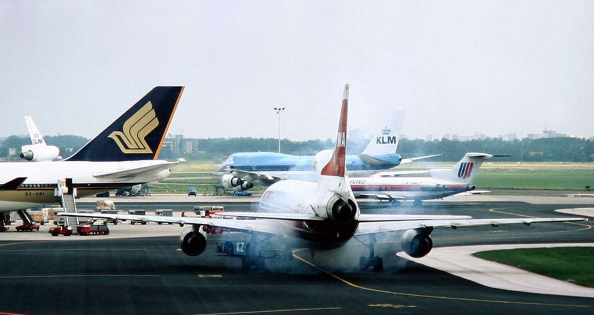
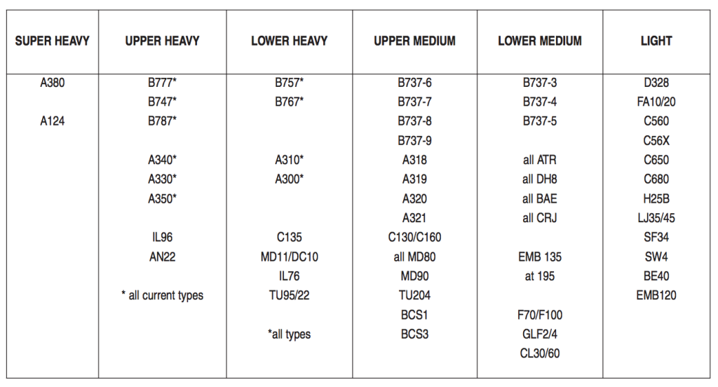
1. Is RVSM Height Monitoring required in the USA?
The United States adopted the requirement for height monitoring in response to ICAO implementing a standard that periodic monitoring was required as specified in Amendment 29 to Annex 6 Part II.

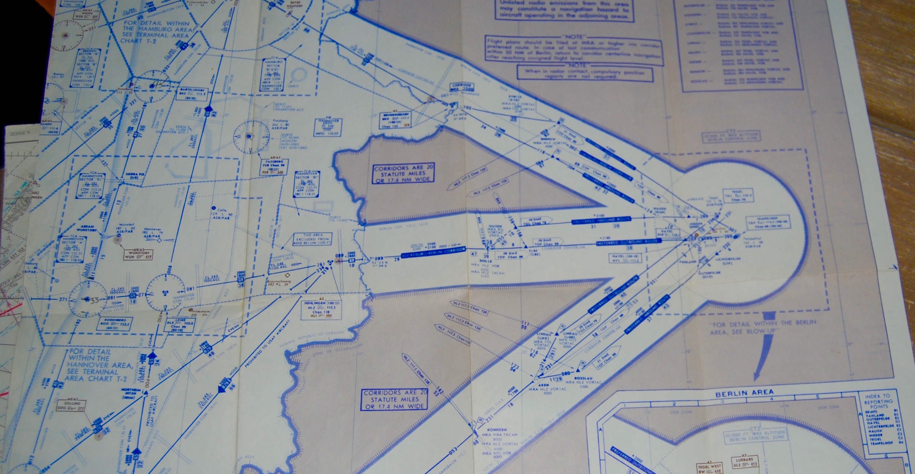
2. I have been asked a question about an airways routing plan out of Israel to Middle East and Africa destinations that are referred to as Red Sea Routes. Have you heard of this?
Saudi “V Routes” are for domestic Saudi operators with government approval Saudi “Uncoordinated flights” (read no slots) can fly over the Red Sea at FL250 Southbound/FL260Northbound Saudi Arabia AIP Enroute 1.1-3 Para: 1.1. 4.2. 4

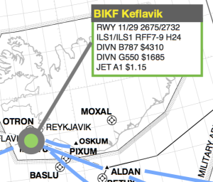
3. Where can I find information about designated HAJJ routes to/from Saudi Arabia?
Special HAJJ routes to/from Africa region airports into Jeddah FIR are published in theDakar AIP Supplement NR 22/a11GO dated 28JUL 11 www.ais-asecna.org

4. What is the requirement for international operations on a crewmember to hold a valid radiotelephone license?
International only.FCC Form 605 Radio Station License Pilots Restricted Station License: http://wireless.fcc.gov/uls and
http://wireless.fcc.gov/commoperators/rp.html

5. Is it legal for me to use my FAA temporary pilot certificate internationally?
Usually a temporary is not accepted,it will depend on the country’s AIP.
6. Is there a maximum age limit for pilots flying internationally?
There is no “Age 60” problem with Part 91/GA operations. The requirement comes in with Commercial operations, (Part 135 or 121). ICAO requires one pilot at the controls to be below 60 if the PIC is over 60. The issue is further confused by the fact that the FAA has applied this to Part 121 carriers only. ICAO countries apply this rule to any commercial operation (Part 135 included). An individual state (country) has the right to set their own rules apart from the ICAO or FAA. The AIP for the country in question would have this information.

7. Is it legal for a Crewmember to have two passports for the USA?
Yes, the US Government allows a US national to have a Second Passport Book (limited validity up to 2 years) for one of 2 reasons. 1. Frequent international travel that requires one to have visas etc. and the conflicting dates/times for the travel to these countries 2. For your personal security when traveling in the Middle East with regards to Israel and the countries that will not allow you to either obtain visas or enter if you have a visa if there is immigration stamp from Israel.

8. I have a conviction in the USA of Driving while intoxicated. Is this a problem in international operations?
This Canadian immigration policy prohibits entry of any person (not just flight crews) who have a 10-year old or less misdemeanor conviction, or any class DUI conviction. The decision to grant or deny the petition for waiver is totally discretionary with the Canadian immigration officials. Review the Canadian immigration web site is a good one. The url is http://www.cic.gc.ca/english/visit/index.asp. If you have any questions about how they enforce this policy, call their Call Centre at 888.242.2100.

9. Do I need an “English Language” endorsement?
Effective 5 March 2008, ICAO Annex 1 (Personnel Licensing) standards required all pilots operating internationally to have an airman certificate with endorsement of English language proficiency (ELP).While many States (countries) complied with the ICAO implementation date, ICAO allowed delays up to three years for countries notifying the organization of intended delays.

10. When checking in with ATC, whether being a new country or simply a new sector in the same country, they seem to want to confirm my routing each and every time. Am I doing this wrong?
There are no specific references as to why this is being done. PANS-ATM, Doc#4444, Paragraph 4.5.7.2. states that the route of flight may be detailed “as necessary” in each clearance. Perhaps the controller’s are using this for verification of your routing and altitude.

11. How does the US Customs define a “Commercial” aircraft?
“Commercial Aircraft” are defined by U.S. Customs regulations as aircraft “transporting passengers and/or cargo for some payment or other consideration, including money or services rendered.” 19 CFR 122.1(d). A “Commercial Aircraft” also includes any aircraft which is not carrying passengers and/or cargo at the time of its inbound CBP clearance, but which, nonetheless, left the U.S. with passengers and/or cargo transported to a foreign area for “commercial purposes.” The rule is not a FAR. The rule is for CBP. CBP do code FAA regulations – 91, 135, 121.

12. How does the US Customs define a “Private” aircraft?
“Private Aircraft” are defined as aircraft which are not carrying passengers and/or cargo for “commercial purposes” (that is, for payment or other consideration). 19 CFR 122.1(h)(1).“Private Aircraft” also may include returning aircraft which are not carrying passengers and/or cargo and did not leave the U.S. with passengers and/or cargo carried for “commercial purposes.” 19 CFR122.1(h)(3). The rule is for CBP. CBP do code FAA regulations – 91, 135, 121.

13. What is the toll-free phone number for ARINC?
From the ARINC website,SFO is 1-925-371-3920, NYC is 1-631-244-2492

14. I got a TCAS/ACAS Resolution Advisory on my last trip in the USA. Do I have any reporting requirements?
The NTSB has issued a final rule that adds six reporting requirements to NTSB 830.5 (a). The reporting requirements became effective March 8, 2010. These new additions specifically address aircraft with turbine engines and glass cockpits, and also include air carriers and fixed and rotary-wing aircraft. One of these elements speaks directly to TCAS/ACAS Airborne Collision Avoidance System (ACAS) resolution advisories issued either (1) when an aircraft is being operated on an instrument flight rules (IFR) flight plan and compliance with the advisory is necessary to avert a substantial risk of collision between two or more aircraft, or (2) to an aircraft operating in class A airspace; NTSB Regional Officeshttp://www.ntsb.gov/Abt_NTSB/regions/AVIATION.HTM

15. I’ve recently heard a pilot mentioning a requirement for “Aircraft operating certificate in Europe” For Part 91 Operations, do we need to comply with this regulation to operate in Europe?
An AOC is not a requirement for an FAA Part 91 General Aviation operation. A change to ICAO Annex 6 in 2010 requires an AOC be in a standardized format and Certified True Copy for commercial operations. This may be part of the confusion. There is an FAA Info to Operators that describes this in detail.InFo#09019 dated 12/1/09. The key is to prove to a foreign inspector that your operation is GA vice commercial. There is an AC that helps. AC 120-12A dated 4/24/86 describes what defines “Commercial Operations”.

16. What is the form number to apply for a Radio Station License?
FCC Form 605. You can do it on-line athttp://www.fcc.gov/Forms/Form605/605.html

17. Can a newly delivered jet with a pink registration can be legally flown from Florida to Puerto Rico and back, with no stops anywhere in between?
“Pink slips” are only valid for the continental U.S., you will need a Flywire to expedite the registration process The flywire will allow you to operate Internationally. Contact information can be found at: http://www.faa.gov/licenses_certificates/aircraft_certification/aircraft_registry/contact_aircraft_certification/”

18. I have heard it both ways and am looking for a FAA reference that states whether operating in the Gulf of Mexico between Houston and Cancun is actually Class II nav.
Class II navigation is any enroute flight operation or portion of a flight operation that is not Class I navigation.FAA Order 8900.1 Volume 4, Chapter 1, Section 4, Paragraph 4-76B.

19. Is a special pilot qualification or training required to operate into/from LFMN, Nice Cote D’Azure?
As a private operator, no special training is required but is recommended. Commercial operators require specific familiarization. Usually a line check and currency is sufficient.French AIP, AD Section
20. Where can I find a copy of the ICAO Annexes?
Try this website: http://www.bazl.admin.ch/dokumentation/grundlagen/02643/index.html

21. How do I get an FAA/FCC approved company Callsign to use internationally?
FAA Advisory Circular 120-26J dated 1/1/05

22. Describe the “Mach Number Technique”
Flying and maintain the aircraft at a constant true Mach number vise an indicated Mach number. NAT Document #007, Guidance Concerning Air Navigation in and above the NAT MNPSA Chapter 7, Paragraph 7.1

23. When is a revised ETA required?
When it is off plus or minus 3 minutes or more. NAT Document #007, Guidance Concerning Air Navigation in and above the NAT MNPSA Chapter5, Paragraph 5.1.6

25. What is a Navigation Accuracy Check?
Prior to entering any airspace requiring the use of a long-range navigation system, the aircraft position shall be accurately fixed using airways navigation facilities or ATC radar. After exiting this airspace, the aircraft position shall be accurately fixed and the long- range navigation system error shall be determined and logged in accordance with the operator’s approved procedures. NAT Document #007, Guidance Concerning Air Navigation in and above the NAT MNPSA Chapter8, Paragraph 8.4.9

26. Can a GPS instrument approach be flown with an expired database?
If the database has expired or, If during the flight the AIRAC cycle changes, operators should establish procedures to ensure the accuracy of navigation data, including suitability of navigation facilities used to define the route of flight, and approach. Traditionally, this has been accomplished by verifying electronic data against paper products. An acceptable means is to compare aeronautical charts (new and old) to verify navigation fixes prior to dispatch. If an amended chart is published for the procedure, the data within the database shall not be used to conduct the operation. The pilot must verify that the instrument procedure has not been amended since the expiration. For en route and terminal use, the pilot must verify the data for correctness if the database is not current. See Table 1-1-6 in the Aeronautical Information Manual and AC 90-100a, Para. #10. AC 90-96a #Para. 2a

27. Name the elements of an oceanic ATC clearance.
3 Elements – Flight Level, Mach and Route. NAT Document #007, Guidance Concerning Air Navigation in and above the NAT MNPSA Chapter5, Paragraph 5.1.9

28. How many nautical miles is 1 degree of latitude?
60 Nautical Miles. FAA H-8083-25A Pilot’s Handbook of Aeronautical Knowledge, Chapter 15, Page 15-4

29. How many nautical miles is 1 degree of longitude?
Depends on latitude, the lines come together at the poles and are farthest apart at the Equator. FAA H-8083-25A Pilot’s Handbook of Aeronautical Knowledge, Chapter 15, Page 15-4

30. Does the ICAO make the rules and procedures internationally?
ICAO does not require any regulation. It sets standards and recommends practices that each signatory State (read country) has the option to accept and enforce or not, in their own regulatory environment. One of the Articles of the Convention guarantees this right. As such, ICAO has no authority over rulemaking in the US, for US Operators.14CFR 91.703 does direct US operators to follow specific ICAO procedures while over the “High Seas”

31. I’ve recently head a pilot mentioning a requirement for “Aircraft operating certificate in Europe” For Part 91 Operations, do we need to compile with this regulation to operate in Europe?
An AOC is not a requirement for an FAA Part 91 General Aviation operation. A change to ICAO Annex 6 in 2010 requires an AOC be in a standardized format and Certified True Copy for commercial operations. This may be part of the confusion. There is an FAA Info to Operators that describes this in detail. InFo#09019 dated 12/1/09. The key is to prove to a foreign inspector that your operation is GA vice commercial. There also is an AC that helps. AC 120-12A dated 4/24/86 describes what defines “Commercial Operations”.

32. I thought that with ADS-C the aircraft was sending position reports to a ground station (once logged on), Why do I have to make HF radio calls?
HF radios would be used to voice report position, maintain a back up to CPDLC. SELCAL would also have to be checked for functionality. Global Operational Data Link Document (GOLD) Chapter 5, Paragraph 5.1.3.7

33. In reference to ATC Clearances, I can’t find a good working definition of the words “At” or “By”
“At” would indicate that the pilot takes the appropriate actions so
as to arrive at the correct position (vertical, lateral,
horizontal) specified in the clearance at the specified time or
location.
“By” would indicate that at the pilot’s prerogative the appropriate
action would be taken so as to arrive at the correct position
(vertical, lateral, longitudinal) before the position specified in
the clearance.
If unsure of what the clearance is requiring, query the controller and get confirmation. ICAO Document #4444, Paragraph 12.3.1, GOLD Document, Appendix A, UM21,UM26 and Oceanic Errors Safety Bulletin, OESB 01-09 “Large Height Deviations” and “Controller Pilot Data Link Communication”

34. Explain why you would expect a time-delay when transmitting position reports and requesting clearances from oceanic communications facilities.
It is important that pilots appreciate that routine air/ground ATS Voice communications in the NAT Region are conducted via aeroradio stations staffed by communicators who have no executive ATC authority. Messages are relayed by the ground station to/from the air traffic controllers in the relevant OAC. Guidance concerning Air Navigation in and above the NAT MNPSA, NAT Document #007, Chapter 6, Paragraph 6.1.1

35. Explain the term “IFBP” and where would you use it?
“The IATA broadcast is a specially formatted position report to enhance situational awareness in Africa and is recommended to be used:
A) In central Africa operations on 126.9.
B) When operating off airways.
C) For flight level changes only.
D) Throughout most of the continent, as a backup to ATC, and as an awareness tool for other aircraft. Broadcasts should be made in the format published on the Jeppesen Africa High/Low Enroute 1 / 2 en-route chart. IATA broadcast is recommended en-route for these specifics:
A) 2-5 minutes before change in flight level
B) At the time of a flight level change
C) 5 minutes prior to a reporting point
In-Flight Broadcast Procedures 5.1 2010 http://www.iata.org

36. Are MET reports required?
ICAO Annex 3, Chapter 5, Paragraph 5.4 and 5.5exempts non-Data Link aircraft from making routine MET reports. However, special reports are required for observations of moderate icing, moderate turbulence, volcanic ash ect.

37. Is there a route from Florida along Cuba to Cancun that is Class I airspace? It seems on the edge; but I have seen references of extended range ground based nav-aids?
This basically comes down to a question of what is the Standard Service Volume for the ground based Navaids involved. SSV is dependent on power output of the facility and the altitude of the aircraft. High VOR’s are listed to have a SSV of 130NM between FL180 and FL450. HH NDB’s have a SSV of 75NM. DME has a SSV of 199NM. This may be the reference to extended range navaids you have seen. Using these mileages, the critical part comes in when crossing the Yucatan Channel between Cuba and Mexico. The shortest route I could find is Gerona NDB (UNG) along UR519 to Cancun VOR (CUN), 227NM between navaids. I cannot find any reference to extended range capabilities of CUN or UNG. 227NM is the mileage listed on the chart along UR519. As an alternate route I would offer UCY, UR506, NUDAL. It is the next best distance at 252NM. Both routes are longer than 205NM (130+75), This would be legal as a Class One routing by 22NM and 47NM. 14 CFR 91.511

38. Where is the datum that MSL (mean sea level) is measured?
“Mean Sea Level (MSL) is a local tidal datum which is determined by averaging the hourly height readings over a specific 19 year period. NOS operates a network of water level stations for which those local datums are determined. The term MSL has also been confused with the geodetic datum, National Geodetic Vertical Datum of 1929 (formerly called the Sea Level Datum of 1929).
http://tidesandcurrents.noaa.gov/datum_options.html

39. I am looking for a site or program that you use to get current weather and information for the city that you are arriving into for the CEO’s review?
Try this website: http://www.intellicast.com/

40. What is a “Maintenance Release” and how do I get one for a FAA Part 91 Operation?
Very basically, the European inspectors are looking for an entry in an aircraft maintenance logbook (Technical Log) that reads something like “On this date aircraft released for XXXdays of flight” and signed off by an A and P maintenance tech. A good description is found in the UK’s CAP 393, Air Navigation the order and procedures, Section3, Item #30

41. How do I find a HF frequency that would work on the ground in the Mid Atlantic area for the purposes of an HF check?
Go to the ARINC-2 page in your Jeppesen subscription. You will find a list of VHF frequencies to contact AIRINC and then ask the Radio Operator which HF frequencies are good at that particular moment. An alternate method is calling NY AIRINC at 631-589-7272.

42. My aircraft is a 1989 model. I do not think it will require a Digital FDR.
From Amendment 29 to Annex 6 Part II, Paragraph 3.6.3.1.2.2All aeroplanes of a maximum certificated takeoff mass of over 5,700 kg for which an individual certificate of airworthiness is first issued on or after 1 January 2005 shall be equipped with a Type 1A FDR

From Amendment 29 to Annex 6 Part II, Paragraph 3.6.3.1.2.3All aeroplanes of a maximum certificated takeoff mass of over 27,000 kg for which the individual certificate of airworthiness is first issued on or after 1 January 1989 shall be equipped with a Type 1 FDR

From Amendment 29 to Annex 6 Part II, Paragraph 3.6.3.1.2.4Recommendation – All aeroplanes of a maximum certificated takeoff mass of over 5,700 kg up to and including 27,000 kg for which the individual certificate of airworthiness is first issued on or after 1 January 1989, should be equipped with a Type II FDR

43. What is the regulation for a requirement to have a First Aid Kit on Board for a Part 91 or Part 135 aircraft?
14 CFR 91.513 and 135.177

44. How do you apply and what do you say when at the counter requesting the second passport?
Go to the State Dep. web site. Complete the DS82 form.The second, or more, passport will have a 2-year term.

45. Where is the requirement for “Emergency Locator Transmitter” “CUT HERE” placards found? FAR’s, EASA, ICAO?
Chapter 11 of your MM will outline the “minimum” placards you must have for your aircraft. Chapter 11 is written IAW the various FAR’s that govern that specific aircraft, (FAR 23 or 25).

46. If we are a US registered aircraft, flying Part 91 into Canada with passengers, picking up more passengers in Canada, and traveling to another Canadian airport, would that be considered Cabotage?
A U.S. private registered aircraft may enter Canada and then stop at more than one Canadian location and that Canadians can embark, disembark or re-embark during the movement through Canada, along with passengers who are “the same passengers who originate outside of Canada.” That section allows the movement of Canadian originating passengers between those points in Canada only if their presence on board the aircraft is incidental to the primary purpose of the trip and no remuneration is involved. http://www.cbsa.gc.ca/publications/dm-md/d2/d2-1-1-eng.html

47. What are the recurrent training requirements for international procedures?
Specific international operations’ training is not required by the FAA regulations or by Annex 2 to the ICAO. FAA Inspector’s have wide latitude in determining crew qualifications for “Special Use Airspace” and “Special Navigation Equipment”. In the FAA Inspector’s Handbook, Order 8900.1 Volume 4 Chapter 12 it states: “Experience has clearly demonstrated that the presence of sophisticated navigational equipment on board an aircraft does not, by itself, ensure that a high level of performance will be achieved.

It is essential that operators provide adequate training for the personnel operating or maintaining the equipment, and that operating drills and procedures are included in crew training.” At a minimum, private operators are expected to “Be Familiar” with the Oceanic/Remote operation intended. Commercial operators usually need to satisfy a crew training requirement by completing an operator’s FAA approved oceanic operations training program or by completing a commercial provider’s oceanic operations training. Military training records indicating prior oceanic operations experience may be use as proof of training also.

48. Where do I Find This Definition of “Special Use Airspace”?
From the FAA aviation safety inspector’s (ASI) Handbook, (FAA Order 8900.1, VOL.4, Chapter 1).

Examples of special areas of operation include the following:
Areas of Magnetic Unreliability (AMU) and Polar operations
North Atlantic Minimum Navigation Performance Specification (NAT/MNPS) airspace
Central East Pacific (CEPAC) airspace
North Pacific (NOPAC) airspace
Pacific Organized Track System (PACOTS)
West Atlantic Route System (WATRS) and the Caribbean Sea
Gulf of Mexico control areas (Gulf routes)
Reduced Vertical Separation Minimum (RVSM)
Required Navigation Performance (RNP)-10,4 ect.

Examples of special Navigation Equipment include the following:
Area Navigation (RNAV)
Inertial navigation or reference systems INS, IRS or GPS

49. What are the recurrent training requirements for European RVSM?
Europe does mandate RVSM training for crews operating there. But, they do not specify initial, recurrent or mandate a frequency of training. If you have been trained at some point in the past that would be accepted as sufficient. During a SAFA check as long as one can show they have been trained it is sufficient. Joint Aviation Authorities Administrative and Guidance Material, Section One, General Part 3, Temporary Guidance Leaflet No. 6, Revision 1, Appendix 4″

50. Many Jepp charts have TERPS or PANS-OPS notated in the lower left margin. Many have nothing notated (e.g.: Canada, Mexico, Panama). If there is no criteria notated does the pilot assume it is under PANS-OPS or assume it is an unspecified criteria specific to that country?
If not annotated on the chart look in the Air Traffic Control section of the Jeppesen Airway Manual and look up the country rules and procedures for the country you operating in. Specifically, look in the Procedure Limitations and Options section of the countries rules and procedures to determine what criteria they use in the development of procedures. The source document of course is the countries Aeronautical Information Publication.

51. Is MNPS required for the ‘Blue Spruce’ Routes, or more specifically, what operational approvals would be required for those routes, and to fly within Europe, for a small Citation under 12,500#?
MNPS approval for the navigation system is required under this condition. The relief from full MNPS requirement is that only one LRNS is required vice, the two normally. The weight/FAR Part 23/25 certification has no part in this. NAT Document #007, Guidance Concerning Air Navigation in and above the NAT MNPSA Chapter1, Paragraph 1.4.1 and FAR 91.511

52. Are SAFA checks applicable to all aircraft, or only aircraft under 12,500#?
“Safety Assessment of Foreign Aircraft” is a EU check of compliance for all aircraft operating in EU countries. ICAO says any country has the right to do this, (FAA has the same authority here). The weight is not a deciding factor in who gets inspected, just what is inspected or expected. Some items like TCAS or GPWS may not be required for aircraft below a 5,700KG/12,500Lbs weight.
http://www.easa.europa.eu/approvals-and-standardisation/safety-assessment-of-foreign-aircraft-SAFA.php”

53. In regards to IRS time limitations for navigation. Where do I find the reference for this limitation?
Time limits on IRS’s are associated with operating in RNAV 10 airspace. Those limitations are published in FAA Order 8400.12B.

54. Where do I find the requirement to add country of manufacture and N# to the aircraft data plates?
What we are referring to is an “Identification Plate” not the “Data Plate”. The a/c data plate can only be issued/changed by the manufacturer. From ICAO Annex 7: “”8. IDENTIFICATION PLATE”

55. Am I required to have a NAT Track Message onboard for the crossing?
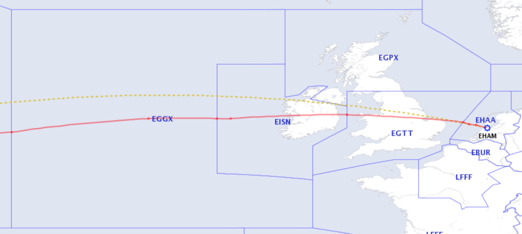
Copies must be available on-board the aircraft. NAT Document #007, Guidance Concerning Air Navigation in and above the NAT MNPSA Chapter4, Paragraph 4.1.1

56. When London Control asks me “What services are we requesting”. What are they asking for?
“Basic Service”, relies on the pilot avoiding other traffic, unaided by controllers/ FISOs. Pilots should not expect any form of traffic information from a controller/FISO. Traffic Service is a surveillance based ATS, where in addition to the provisions of Basic Service, the controller provides specific surveillance-derived traffic information to assist the pilot in avoiding other traffic.
“Deconfliction Service” is a surveillance based ATS where, in addition to the provisions of a Basic Service, the controller provides specific surveillance-derived traffic information and issues headings and/or levels aimed at achieving planned deconfliction minima, or for positioning and/or sequencing.
“Procedural Service” the controller provides restrictions, instructions, and approach clearances, which if complied with, shall achieve deconfliction minima against other aircraft participating in the Procedural Service.
CAP 774 UK Flight Information Services”

57. What document defines “Class Two Navigation” for the FAA?
Any navigation that is not Class One.
FAA Order 8900.1 Volume 4, Chapter 1, Section 4, Paragraph 4-76B.

58. What is a “Minor Repair” to a SAFA inspector in the UK?
A minor repair or modification means one which has no appreciable effect on the mass, balance, structural strength, reliability, operational characteristics, noise, fuel venting, exhaust emission or other characteristics affecting the airworthiness of the aircraft, part or equipment. UK’s CAP 393, Air Navigation the order and procedures, Section3, Item #30

59. If SELCAL isn’t functioning in Oceanic/Remote airspace. Can I continue the flight?
Yes, SELCAL meets the “Continuous listening watch” requirement of 14 CFR 91.511. If SELCAL is inoperative one of the pilots must listen on the appropriate enroute frequency for calls.

60. What document can pilots refer to find “Country or Region specific” information?
That country’s Aeronautical Information Publication is the source.Jeppeson reprints some of this information in the ATC Section of their publications. ICAO Document #7030 and FAA AC 90-70A are additional resources

61. Where would you find intercept procedures?
ICAO Annex 2, chapter 3, paragraph 3.8, and attachment Acontains guidance for international interception procedures. Appendix 1 of Annex 2 contains international interception signals. Further information is found in ICAO Document #4444, Section 15, Paragraph 15.5.1 and 15.5.2.

62. Is specific training required to be conducted in the area of Foreign ATC terminology and verbiage?
No. Recommended reading on this subject: ICAO Annex 10, Volume2. ICAO Document 9432, UK’s CAP 413 and the FAA’s Pilot/Controller Glossary

63. Define “Loop Error” and describe how you will guard against this risk.
Misunderstanding of clearance details between the pilot and the controller. This is one of the reasons that in the NAT pilots are required to report before leaving any altitude and upon reaching a new cruising altitude. NAT Document #007, Guidance Concerning Air Navigation in and above the NAT MNPSA Chapter 9, Paragraph 9.1.15

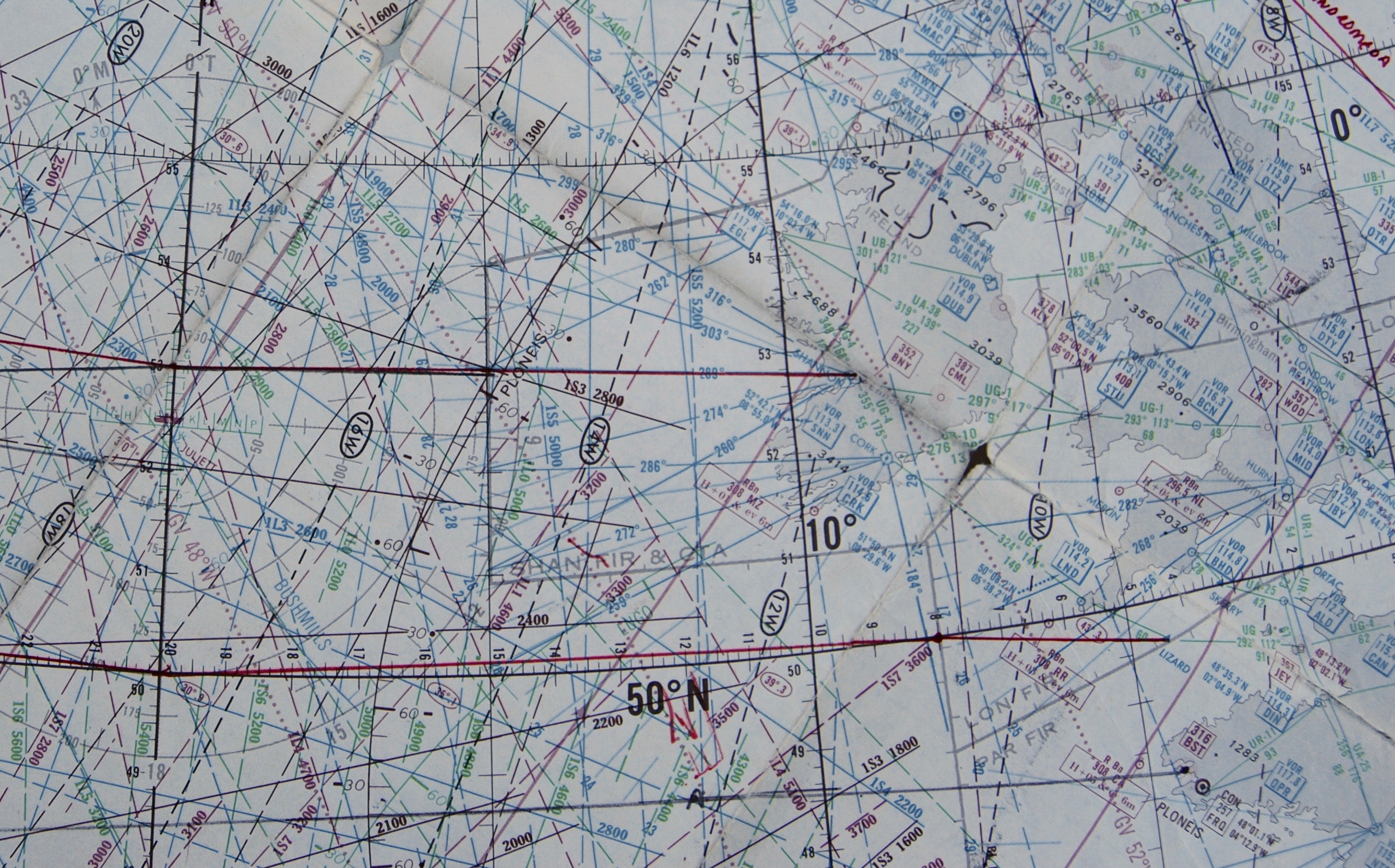
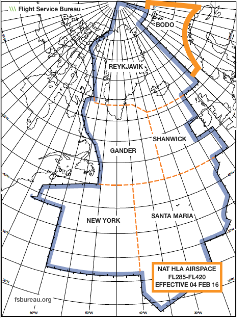
64. What should you consider doing when overtaking another aircraft that is 1000 feet below your altitude directly underneath your flight track?
An aircraft overtaking another aircraft should offset within the confines of this procedure, if capable, so as to create the least amount of wake turbulence for the aircraft being overtaken. NAT Document #007, Guidance Concerning Air Navigation in and above the NAT MNPSA Chapter 8, Paragraph 8.5.3

65. Briefly describe MNPS dimensions
“The vertical dimension of MNPS Airspace is between FL285 and FL420 (i.e. in terms of normally used cruising levels, from FL290 to FL410 inclusive). The lateral dimensions include the following Control Areas (CTAs): REYKJAVIK, SHANWICK, GANDER and SANTA MARIA OCEANIC plus the portion of NEW YORK OCEANIC which is North of 27°N but excluding the area which is west of 60°W & south of 38°30’N NAT Document #007, Guidance Concerning Air Navigation in and above the NAT MNPSA Foreword

66. When should we squawk 2000?
When reaching oceanic airspace, squawk 2000 and monitor VHF 121.5 and the air-to-air frequency 123.45. FAA AC 90-70A Chapter 5, Paragraph 5.5

67. Briefly describe the cockpit set-up for VHF radios (121.5, 123.45) in Oceanic/Remote airspace.
When reaching oceanic airspace, squawk 2000 and monitor VHF 121.5 and the air-to-air frequency 123.45. FAA AC 90-70A Chapter 5, Paragraph 5.5

68. Is a master clock required to be designated in Oceanic/Remote airspace?
Yes. NAT Document #007, Guidance Concerning Air Navigation in and above the NAT MNPSA Chapter 8, Paragraph 8.2.2 FAA AC 90-70A Appendix 2 Paragraph 2

69. What is the allowable Track and Distance difference, from each waypoint displayed in the FMS vs. Master Document?
2-3 degrees and 1-2 NM. These small differences are there due to the individual FMS calculations of track and distances vs. flight planning computers calculation. Larger differences need to be investigated and resolved. NAT Document #007, Guidance Concerning Air Navigation in and above the NAT MNPSA Chapter 8, Paragraph 8.3.18

70. When should we give a new ETA?
Time Error. Occurs when an aircraft’s reported actual time of arrival (ATA) is more than 3 minutes before or after the estimated time of arrival (ETA). (For North Atlantic (NAT) the criteria are 3 minutes or more.) FAA ORDER 7110.82D Effective Date: 06/03/09

71. Generally speaking, how many minutes prior to entering Oceanic/Remote airspace, should you have the Oceanic Clearance?
It is recommended that pilots should request their Oceanic Clearance at least 40 minutes prior to the Oceanic entry point ETA except when entering the Reykjavik area from the Scottish or Stavanger areas, then the clearance should be requested 20 minutes before the Oceanic entry point ETA. NAT Document #007, Guidance Concerning Air Navigation in and above the NAT MNPSA Chapter 5, Paragraph 5.1

72. What defines a Gross Navigation Error GNE?
GNE. Lateral errors of 25 nautical miles (NM) or more from the aircraft’s cleared route. FAA ORDER 7110.82D Effective Date: 06/03/09

73. What defines a Large Height Error?
Height Error. Errors of 300 feet or more from a clearance altitude. FAA ORDER 7110.82D Effective Date: 06/03/09

74. What defines a Time Error?
Time Error. Occurs when an aircraft’s reported actual time of arrival (ATA) is more than 3 minutes before or after the estimated time of arrival (ETA). (For North Atlantic (NAT) the criterion is 3 minutes or more.) FAA ORDER 7110.82D Effective Date: 06/03/09

75. Briefly describe 14 CFR 91.703
When over the high seas, comply with annex 2 (Rules of the Air) to the Convention on International Civil Aviation and with 91.117(c), 91.127, 91.129, and 91.131; When within a foreign country, comply with the regulations relating to the flight and maneuver of aircraft there in force.

76. Do I need a French Crew visa?
Travel to France on the continent of Europe does not require an Schengen visa for crewmembers. France also has 4 overseas departments that are wholly integral parts of France and considered equally among the country’s 28 regions. The Overseas Departments (département d’outre-mer, or DOM) include Guadeloupe (Le Raizet- TFFR), Guyane (Cayenne-Rochambeau- SOCA), Martinique (Le Lamentin- TFFF) and Reunion (Saint Denis- FMEE). However, the Schengen visa does not apply to the Overseas Departments. There is a specific visa for visits to DOM. Details regarding all French visas can be found @ the French Embassy website.
http://www.consulfrance-washington.org/spip.php?rubrique98

77. Explain the term “SLOP” the procedure for applying it.
Strategic Lateral Offset Procedure. Aircraft can fly in automatic mode 1 or 2 N.M. to the right of centerline of the cleared course. Position reports are given as if you are crossing the actual waypoint. When entering and exiting oceanic airspace you must cross the actual waypoint.ICAO Doc#4444, Chapter 16, Paragraph 16.5″

78. If an aircraft is required to deviate from track to avoid adverse meteorological conditions and a prior clearance cannot be obtained, what are the PIC responsibilities?
Alert other near by aircraft, turn on exterior lights, if more than 10 N.M. off course and flying eastbound then descend 300’ if north of course or climb 300’ if south of course; if westbound then climb 300’ if south of course and descend 300’ if north of course. ICAO Doc#4444, Chapter 15, Paragraph 15.2.3

79. How do I locate RVSM monitoring flight information on the FAA web site?
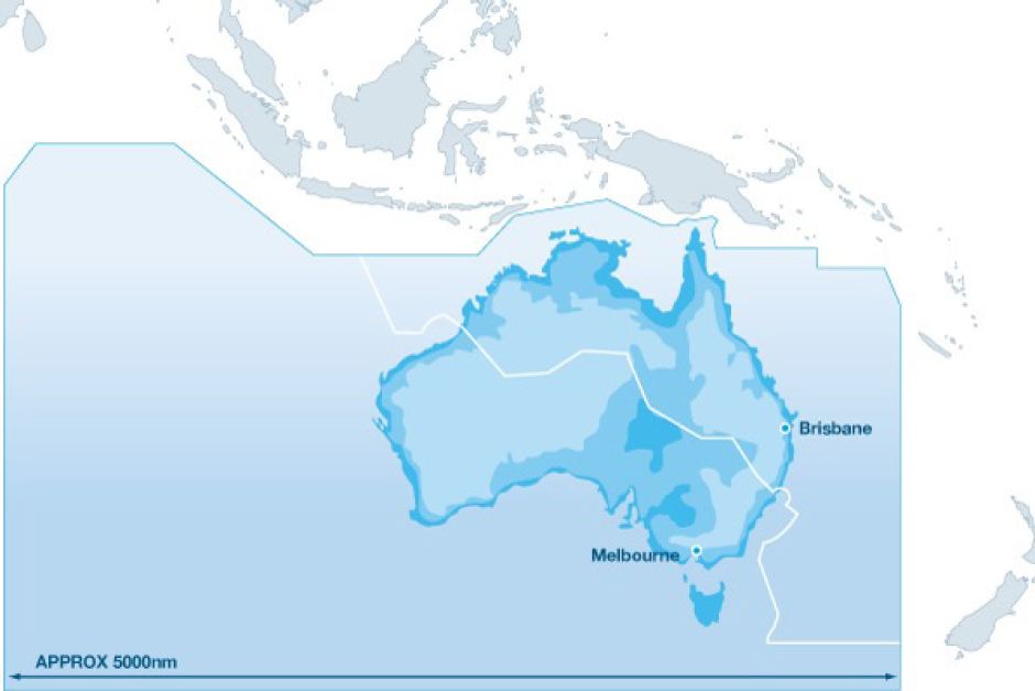
The FAA RVSM Approvals page link is: http://www.faa.gov/air_traffic/separation_standards/naarmo/rvsm_approvals/Look under International General Aviation “IGA”

80. What are the requirements for carrying and using an oceanic plotting chart?
There is no specific regulatory requirement for plotting charts. Check your specific operations approval documents for details on your operation. The requirement is to be able to reliably fix your position and cross-check navigation information. AC 91-70A Para 3.6

81. How many aircraft within a fleet must have completed a RVSM monitoring flight to satisfy the European requirement?
Group approved and indicates data indicates RVSM compliant, 2 Aircraft per fleet. Group approved with insufficient data or Revs compliance, 60% or airframes Non group aircraft, 100% of airframesICAO Annex 6, Part I, Para. 7.2.7, Part II Para. 2.5.2.7 http://www.ecacnav.com/content.asp?PageID=65

82. What is a Journey Log Book?
A Journey Log Book shall be maintained in respect of every aircraft engaged in international navigation. In this log shall be entered particulars of the aircraft, crew and each journey. Recommended items are aeroplane nationality, registration, date, crew names and duty assignments, departure and arrival times and points, purpose and observations of the flight, PIC signature.ICAO Article 29, 34, ICAO Annex 6, Part 1, Paragraph 11.4
ICAO Annex 6, Part 2, Paragraph 2.8.2

83. How does a U.S. operator satisfy the requirement for a Journey Log Book according to the FAA?
The term logbook in this context means a navigation log and/or plotting chart that may be kept in the form of electronic data. This record should be maintained for 6 calendar months following the flight.FAA Order 8900.1 Volume 4, Chapter 12, Paragraph 4-1299 c

84. How do I determine if a country is WGS 84 compliant?
The specific country’s Aeronautical Information Publication, AIP will list this information. An FAA approved source for this information may be found at: http://www.jeppesen.com/company/publications/wgs-84.jsp”

85. What is the difference between the RNAV Specification and the RNP Specification for airspaces based on Performance Based Navigation?
RNAV specifies navigation accuracy only. RNP specifies navigation accuracy, alerting and monitoringICAO Doc# 9613, “Executive Summary”

86. Is it legal to carry fireworks onboard a part 91 flight?
They are a HAZMAT, Class 1.3 or 1.4 explosive ground transport only. 49 CFR 172.101

87.When are passengers entering the United States on a Part 91 flight required to have a visa?
US Citizens do not require a visa. Non-US citizens require a visa if; they are not a citizen of a country that the US permits a waiver from. The Visa Waiver Program (VWP) and The Electronic System for Travel Authorization (ESTA) is what we are speaking of here. Frequently Asked Questions about the Visa Waiver Program and the Electronic System for Travel Authorization
http://www.cbp.gov/xp/cgov/travel/id_visa/business_pleasure/vwp/”

89. What is the meaning of listing airport elevation in hPa on some Jeppesen approach plates?
It is the difference between field elevation and the altitude. Another way of stating this; this is the Barometric pressure equivalent for QFE at airports with altimeter setting in hPa or Mb.Jeppesen Introduction Section, Page #103″

90. Are there fuel remaining requirements from and Equal Time Point to the diversion airport?
For private operators, there are no regulatory requirements for fuel remaining at ETP of oceanic/remote diversion airports. Commercial operations or Extended Range (ETOPS) do have specific planning requirements.AC 91-70a and AC 120-42b, UK CAP 513″

91. What are the requirements to become approved for RNP-4?
Long-range navigation systems capable of RNP-4 navigation are required for the LOA/OpSpec to be issued. To use RNP-4 in a 30/30NM separation standard ADS-C and CPDLC will be requiredPBN-BASED RNP 4 JOB AID, 5/6/09 FAA Order 8400.33, 9/15/05″

92. I’ve recently heard a pilot mentioning a requirement for “”Aircraft operating certificate in Europe” For Part 91 Operations, do we need to compile with this regulation to operate in Europe?
An AOC is not a requirement for an FAA Part 91 General Aviation operation. A change to ICAO Annex 6 in 2010 requires an AOC be in a standardized format and Certified True Copy for commercial operations. This may be part of the confusion.There is an FAA Info to Operators that describes this in detail. InFo#09019 dated 12/1/09. The key is to prove to a foreign inspector that your operation is GA vice commercial. There is an AC that helps. AC 120-12A dated 4/24/86 describes what defines “”Commercial Operations”.

93. I thought that with ADS-C the aircraft was sending position reports to a ground station (once logged on) Why do I have to make HF radio calls?
HF radios would be used to voice report position, maintain a back-up to CPDLC. SELCAL would also have to be checked for functionality.Global Operational Data Link Document (GOLD) Chapter 5, Paragraph 5.1.3.7
140. Where in the world does RNP 4 airspace exist?
RNP-4 is used in support of 30/30NM separation in the SOPAC.FAA Order 8400.33, 9/15/05

94. Does a Part 91 operator require a LOA or specific training to conduct operations in the Polar region?
No LOA nor specific training is required for a Part 91 operator to conduct Polar operators. However, specific navigation authorization is required for commercial operators.FAA Order 8900.1 Vol.4, Chap.1, Sec.2, Para 4-24″

95. Where in Annex 6 does it state that an ELT must operate on 406 MHz?
ICAO does not have a requirement for a specific ELT transmitter. Annex 6 describes how many and if automatic or not, Annex 10 describes specifications for the actual transmitter. An individual country’s Aeronautical Information Publication, AIP will state the requirement for Either 121.5 or 406MHz transmitters.ICAO Annex 6, Part I, Para. 2.4.12 ICAO Annex 10 Volume III, Part II, Chapter 5.”

96. Do the North Atlantic Region lost communications procedures apply in the WATRS Plus airspace?
No, the Western Atlantic Area is a different designation than NAT/MNPS. You are expected to comply with ICAO Doc#4444, Chapter15 while in the WATERS Plus area.The US NOTAMS, International section describes this in detail and can be found at: http://www.faa.gov/air_traffic/publications/notices/”

97. Where would you look for the route information if cleared on the following clearance in Canadian Airspace, FOXXE N26A SPOTE N28A MT N32A SSM?
This is a combination of three different North American Routes. These routes are described in general terms in theNAT Document #007 and in detail in the FAA’s Northeastern Facilities Directory or the Canadian Flight Supplement.

98. Is it possible to do CPDLC with AFIS?
No. These are two separate and distinct communication protocols.Global Operational Datalink Document, GOLD Chapter 3, Paragraph 3.1

99. Can I pass position reports via AFIS?
No. But, FMS Waypoint Position Reporting (FMS WPR) is available in the NAT with approval from the specific OCA.Nat DOC#007, Paragraph 6.1.20

100. When accomplishing a position accuracy check, the FMS position should be checked against what navigation sources?
A ground based NAVID such as a VOR/DME or a RADAR position plot from ATC.AC91-70a, Chap.10 and NAT Doc. 007 Para. 8.4.9