New RISK WARNING: Somalia ATC Conflict

Update Nov 2025: Somalia-Somaliland Airspace and Permit Dispute 

Be aware of an ongoing authority dispute in the north of the HCSM/Mogadishu FIR. Both Somalia and the self-declared state of Somaliland have issued conflicting instructions for overflights. From Nov 10, Somaliland says all flights require PPR from its own CAA, while Somalia has reaffirmed through an AIC that it controls the entire FIR and operators should follow its AIP.

Expect mixed messages on permit requirements near northern Somalia and the Hargeisa region. The Somali CAA remains the only internationally recognised authority for all Class A airspace above FL245 – be cautious of conflicting or unauthorised clearances.

For background on this long-running dispute and its impact on ATC safety, see safeairspace.net.

Ongoing since Feb 2024: ATC Conflict in Somalia

Key information for Flight Crew

Over the weekend, OPSGROUP has received at least 10 reports of aircraft within the Mogadishu FIR being contacted by a ‘fake controller’ on the same frequency, issuing conflicting instructions.

Crews have been issued climb and descent clearances that are not from the sector controller. Incidents have been reported mostly in the northern part of Mogadishu airspace.

The situation emanates from a political dispute between Somaliland and Somalia, two different countries, though the former does not have international recognition. Both countries now claim authority over the Mogadishu FIR.  

Quick Summary – ATC Conflict in Somalia

  • This affects aircraft transiting the Mogadishu FIR
  • Enroute aircraft are being addressed by competing ATC units on the same frequency.
  • Numerous aircraft have received climb/descent instructions from unauthorized ATC units.
  • Location: Primarily within radio range of Hargeisa (VHF 132.5), also via HF (11300)

OPSGROUP Members

In your Dashboard you’ll find the full Risk Warning, including Crew Reports, Maps, Analysis, and Guidance. If you can’t access, just email the team and we’ll send you a copy.

Download the Risk Warning (PDF, 9 pages, 2Mb) 

Analysis

(Excerpt from the Risk Warning in your dashboard)

The background to the situation is an escalating political dispute between Somaliland and Somalia. Somaliland has been an independent country since 1991, but without international recognition. Somaliland has to date maintained control over its airports, but Somalia controls the upper airspace from Mogadishu.

In January 2024, Ethiopia signed an agreement with Somaliland, essentially exchanging port rights on the Red Sea for recognition of their country. This was met with condemnation by Somalia. Somalia, in response, began restricting movements into Somaliland by way of denying airspace entry to the Mogadishu FIR in some instances. This has led to Somaliland declaring its right to exercise control over their airspace.

The net result is an airspace dispute between the two territories. Both Somalia and Somaliland now claim the right to control traffic. This is why crews have been contacted by other “controllers” on 132.5 (VHF) and 11300 (HF). Although it is likely that these other “controllers” are genuine Air Traffic Controllers, they are operating outside their area of jurisdiction as things stand.

Currently, the authority over the entire Mogadishu FIR is Mogadishu Control. They remain the sole authority to control, coordinate, and provide ATS services in the Upper FIR. The secondary transmissions are coming from Hargeisa in Somaliland. Although the motive for these transmissions can be understood, they present clear danger to enroute traffic. The transmissions appear to attempt to mimic Mogadishu rather than present as “Hargeisa Control”, “Somaliland Control”, or any clear differentiator from Mogadishu.

It would also appear from the reports that we have received, that the control instructions are not being issued to de-conflict traffic, but rather to create confusion. This may be an effort to draw attention to the airspace issue, but could have tragic consequences. For flight crews, we follow with some guidance to mitigate the situation.

The situation is volatile and may escalate. On Sunday, February 18, an AIS Officer from Somaliland, working in Mogadishu, was found dead at his home. His death appears related to this situation.

Avoidance of Mogadishu airspace would provide ultimate safety, and if the situation continues, would be wise.

[Excerpt, see full Risk Warning for crew reports received, maps, guidance] 


Worldwide GPS Dual Failure mystery solved

The mystery of the dual GPS failures around the world has been solved.

Last week, a slew of Dual/Complete GPS Failures began to be reported by airlines and AOs around the world. A peak of failure reports were received around May 21. Typically, the fault was first annunciated as an “ADS-B RPTG” Fault, followed by GPS 1/2 failure. Aircraft affected were mostly B737 and A320 series, though some widebodies also caught the lurgy.

Initially, no clear cause could be established. There were theories about new spoofing and jamming areas, solar flares, sunspots, and troubling new hacker activity. But none of those lined up with the symptoms.

However, over the weekend, the culprit was traced to a single faulty satellite, GPS PRN 37. Data from the broadcast of this satellite led to the on-board failures that we saw.

Thanks to all OPSGROUP members that assisted with the “ALL CALL” that went out on Friday, there was a great response and we were able to collect a great deal of information. An Ops Alert was issued to members on Sunday, which reads:

ZZZZ/Worldwide - Hazard  The mystery of worldwide dual GPS failures appears to have been solved. Over the weekend Boeing, Honeywell, and Collins collaborated to investigate the cause, and the outcome is that the faults were traced to one GPS satellite (PRN 37). A change in the data format being broadcast from it apparently led to the receiver failures. These were limited to Honeywell MMR's, predominantely on B737 and A320 series aircraft. This change has been corrected, and no further issues are expected. There was no connection to an increase in solar activity, or jamming/spoofing. The three OEM's involved consider the case closed. Thank you to all members who responded with reports and information.

A special briefing is in your member Dashboard, which includes crew reports of the issue.

NANU NANU

There was a warning (published as a NANU message) to GPS users published earlier in the year, that warned of unhealthy navigation messages being broadcast on GPS satellites 35, 36 and 37 throughout 2025. Let’s hope that any rogue signals from PRN 35 or 36 don’t have the same effect down the track.

NOTICE ADVISORY TO NAVSTAR USERS (NANU) 2025017 NANU TYPE: GENERAL
*** GENERAL MESSAGE TO ALL GPS USERS ***
Testing will be occurring through CY 2025 using PRNs 35, 36, 37 
on residual SVs broadcasting UNHEALTHY navigation messages.
*** GENERAL MESSAGE TO ALL GPS USERS ***

POC: CIVILIAN - NAVCEN AT 703-313-5900, HTTPS://WWW.NAVCEN.USCG.GOV
MILITARY - GPS WARFIGHTER COLLABORATION CELL at 
HTTPS://GWCC-WS.CCE.AF.MIL/GPSOC, DSN 560-2541, COMM 719-567-2541,
gpsoperationscenter@us.af.mil, HTTPS://GWCC-WS.CCE.AF.MIL
MILITARY ALTERNATE - JOINT SPACE OPERATIONS CENTER, DSN 276-3526. 
COMM 805-606-3526. JSPOCCOMBATOPS@US.AF.MIL

High levels of Pilot Error with NAT RCL: New Briefing and Checklist

The number of pilot errors following the introduction of the new “No Oceanic Clearance” procedure is turning out to be far higher than expected. As a result, Gander have had to implement an evening Airspace Flow Program (AFP), restricting eastbound traffic.

Since December 4th, Oceanic Clearances are no longer being issued by Gander for eastbound flights, and a new procedure is in place using an RCL message to send your desired time, level and speed at the Oceanic Entry Point (OEP).

However, the very high level of non-compliance with this new procedure is surprising and troubling. Errors by flight crew fall into a number of different categories, but can be summed up in a “Top 5”, including sending the RCL at the wrong time, asking for an Oceanic Clearance, “DIY” level changes, wrong handling of RCL Rejected messages, and repeated voice requests for “route confirmation” blocking active ATC frequencies.

A new Crew Brief and Checklist has been published today, which you can download below. Please save a copy, and send to your crew and colleagues!

Download the Gander RCL Crew Brief and Checklist (PDF, 1Mb)


Top 5 Pilot Errors

  1. WRONG RCL TIME. Send it when you are 90-60 mins from your entry point. Not before, not after. The 1 hour cutoff is strict.
  2. ASKING FOR AN OCEANIC CLEARANCE. They are gone, finished, done. (for NAT eastbound). ATC can’t give you one, so don’t ask!
  3. CLIMBING WITHOUT APPROVAL. (Or descending). Too many are getting this wrong. ATC will ensure you are at the right level at the OEP. Don’t “do it yourself”.
  4. WRONG HANDLING OF “RCL REJECTED”. You’ll get this if you send your RCL early or late. If late, just tell ATC on the current frequency what your RCL says. Then you’re done. You won’t be handled any differently. No “Oceanic Clearance”.
  5. ASKING FOR ROUTE CONFIRMATION. Don’t do it, it blocks the frequency and increases ATC workload. ATC auto-queries your FMS to ensure it’s correct.


Notes on the RCL process

  1. The RCL is a one-and-done message with your desired level and speed. You won’t get a clearance, so don’t ask for one! Send your RCL at the right time. The 1 hour cut-off is firm. If you do have to use voice (e.g late, or no ACARS) – just read out the RCL with current ATC, and you’re done.
  2. Domestic ATC (the radar sector before the ocean) is responsible for getting you to the level Oceanic ATC has assigned you. IF your RCL level is available, they will clear you. Don’t just climb yourself. Nil comms means no change, stay where you are.
  3. At the Oceanic Entry Point, maintain whatever level Domestic ATC has assigned – this is your ocean level. Set speed to Econ/Cost Index, or a Fixed Mach if so assigned. Your route is automatically queried with a “Confirm Assigned Route” message – no need to confirm via voice.
  4. Once in the ocean and traffic permits, you can expect an advisory that your RCL level is available if you didn’t get it earlier. If you have an Assigned Mach, when able, ATC will issue “Resume Normal Speed“. This means fly RCL speed (Cost Index), and notify of +/- 0.02 changes to this speed.

Worried about getting it wrong?

Of course, it always makes sense to double check any uncertainties, but if you can keep it off the frequency, that’s very helpful for ATC. At the moment, there is a high volume of extra requests (which makes life hard for the controller). Remember one key point: ATC systems are continually monitoring your route, speed, and level, and will advise of any discrepancy. Your route in the FMS is queried by a UM137 message (“CONFIRM ASSIGNED ROUTE”), to ensure both you and ATC have the same understanding of your track, or random route acoss the Ocean.

If you’re not certain about how the procedure works, use the Crew Brief and Checklist (developed specifically for Gander Oceanic), and refer to NAT Ops Bulletin 2023_001 Rev 4, and NAT Doc 007.

Can you share? Please do.

The quicker we can get this information out to all NAT crews, the better. Please share with your flight department, fleet, or operation – just download the Crew Brief and Checklist and pass it on.


Questions? Can we help?

If you have a question about the new RCL process, just comment below or send us an email. We want to help make sure that we are all on the same page!


Winter Ops: Fun Fuel Facts

Fuel is to airplanes what coffee is to pilots – something you just cannot fly without. But just as there are different types of coffee, you’re going to come across different types of fuel as well…

The Menu

Jet-A1 – The most traditional drink, it is straw coloured with a flash point of 38°C (100°F), and a freezing point of -47°C.

Jet A – Another tasty kerosine grade fuel which will work just fine. The flash point is the same but this turns into an icy slushie at only -40°C.

Jet B – A delicacy from the Northern Regions. This is a cocktail of kerosine and naphtha – the stuff dragons produce out their nostrils (ok, that is not true, but it might as well be because this stuff is hard to handle with its higher flammability). Wide cut, and only really used in colder climates, with its freezing point of -50°C.

TS-1 – A Russian cocktail, more flashy than most at 28°C, but with a freezing point of -50 °C. It is also sometimes called RT (which looks like PT when it is written in Russian). RT is a superior grade TS-1, but not widely available.

RP – Brewed in China, the RPs come in a variety of styles. RP-1 has a freezing point of -60°C, RP-2 -50°C, but it is RP-3 we really recommend because it is basically Western Jet-A1 produced at export grade.

Chip fat oil – Not literally, but if you fly into a remote airport in some regions you might find fuel is not of the standard required. Look out for anything that isn’t straw coloured, doesn’t smell right, or has things floating in it.

Cutting it wide

Wide cut fuel is a mixture of kerosene and gasoline (Jet A1 in comparison is highly refined Kerosene). Wide cuts are not often recommended by airplane manufacturers because the quality and performance specifications are generally not as good.

If you are going to use it, there are likely going to be some pretty specific operational procedures involved because these fuels are much more volatile. Things like over-wing fuelling is generally a no-no, and the filtration system is going to appreciate a slow flow so it can keep up.

All those numbers

Fuel doesn’t freeze like water. It is not liquid one minute and ice the next. Instead it turns into a strange, slushy porridge consistency. 

What’s more, if you have a mixture of freezing points, the freezing point won’t be a nice in the middle -44.5°C so the only reliable way to work this out when you’ve mixed a load together is to take a measurement – assuming you’re carrying your own Fuel Freezing Point Measuring Gadget…

If not, the next best method to use is this –  

  • 90% or more of your fuel is one type? Use that freezing point.
  • 89% or less of your fuel is one type? Use the highest (worst case) freezing point.
  • You have 900 gallons of Jet A1 freezing at -47°C and 100 gallons of Jet A freezing at -40°C? Then call it -47°C and be off on your merry way.
  • You have 899 gallons of Jet A1, and 101 gallons of Jet A? Then take the highest freezing point which in this case would be Jet A at -40°C

Do we really care about freezing points of fuel?

Yes, very much so, especially if you are flying some long haul treks over the North Pole at high altitude in the winter.

With outside air temperatures lower than -60 degrees, freezing fuel can get you into some very hot water, (or cold fuel to be more accurate.)

In Jan 2008, British Airways Flight 38 crashed just short of the runway at EGLL/Heathrow after flying from Beijing, China. They had been cruising between FL350 and FL400, with OATs reported to be between -65 to -74°C. While the fuel itself never froze, it did become cold enough for ice crystals to form in the fuel system.

These pesky little ice particles blocked stuff up and reduced the fuel flow, starving the engines, and causing a big loss in thrust right when the pilots needed it.

What can we do about it?

Ultimately, you need to turn up the temperature! There are only a few ways to heat your fuel up if it starts getting too chilly:

Stir it Up – Unlike Bond who preferred his drinks shaken and not stirred, mixing cold fuel with warmer fuel makes it better. Some larger aircraft with complex fuel systems do this automatically, but if you are able to do so manually there will probably be a checklist and following it to avoid turning off the wrong pumps might be wise.

Speed it Up – Flying faster means more drag which means more energy converted into hotness. Not much though… an increase in Mach 0.01 will increase the TAT by around 0.7°C, and increasing your speed also increases your fuel burn.

Bring it Down – Warmer air will help, and by descending 7000’ you can increase the TAT by around 7°C. In seriously cold air masses, descent to at least FL250 might be required, but this all means a much higher fuel burn.

Tanker? No thank ya…

Tankering fuel if you are operating into somewhere chilly might cause you some problems. The fuel is likely to get cold in flight, and up the likelihood of some frosty wings on the ground. So check the de-icing situation at your destination if you are tankering and it’s cold out.

Some other useful info

  • 1 imperial gallon = 1.2 US gallons.
  • You can monitor the price of jet fuel here.

NAT Guide 2025 – My First NAT Flight is Tomorrow

The latest edition (2025) of the NAT Guide (“My First North Atlantic Flight is Tomorrow”) has now been published. This 24-page guide is for pilots and dispatchers, to help you understand the basics of North Atlantic flying.

Contents:

  • 1. What’s different about the NAT?

  • 2. Changes in 2024, 2023, all the way back to 2016.

  • 3. (Updated 2024) Circle of Entry – a visual depiction of what equipment is needed to enter the different parts of the NAT region airspace.

  • 4. NAT Quick Map – Gander boundary, Shanwick boundary

  • 5. Routine Flight Example #1 – Brussels to JFK (up at 5.45am) – NAT HLA certification, Oceanic Paperwork, Special requirements, getting an Oceanic Clearance, Equipment failure, Weather deviation, and going off track.

  • 6. Non Routine-Flights: No PBCS, No RVSM, No RNP4, No HF, 1 LRNS, No HLA, No ETOPS, No TCAS, No Datalink – what you can do and where you can go.

  • 7. Diversion Airports guide: A couple of notes on each of the most popular diversion airports from Shannon to Goose Bay: What to expect.

  • 8. Airport data: BGBW Narsarsuaq, BGSF Sondy, BIKF Keflavik, EGPF Glasgow, EGPK Prestwick, LPLA Lajes, LPAZ Santa Maria, EINN Shannon, EIDW Dublin, CYFB Fro Bay, CYYR Goose Bay, CYQX Gander, CYYT St. Johns, LPPR Porto, LPPT Lisbon, TXKF Bermuda.

  • 9. Overflight permits – routine and special, non-standard airworthiness, how to get one.

  • 10. Special NAT procedures: Mach number technique, SLOP, Comms, Oceanic Transition Areas, A successful exit, Screwing it up, Departing from Close Airports

  • 11. North Atlantic ATC contacts – Shanwick, Gander, Iceland, Bodo, Santa Maria, New York – ATC Phone, Radio Station Phone, AFTN, Satcom, CPDLC Logon codes; and adjoining Domestic ATC units – US, Canada, Europe.

  • 12. NAT FPL Codes and Flight Levels

  • 13. The Contingency procedure – weather and diversions

  • 14. Flight Plan Filing Addresses by FIR

  • 15. NAT Clearance or no Clearance, guide to the new RCL process.
  • 16. Common Gotchas: ATC and OPSGROUP Member favorites.

  • 17. Links, Questions, Guidance


There are two options to download a copy of the NAT Guide 2025 (24 pages, 6Mb)


OPSGROUP Members

You can get it in your Dashboard, under Briefings and Guides.


Get it from the OPSGROUP Store

Not a member? Get a copy from the OPSGROUP Store.


NAT Circle of Entry (2025)

For the latest changes and updates on the North Atlantic, including our most recent Guides and Charts, use our NAT reference page at ops.group/blog/nat/

We’ve updated the NAT Circle of Entry for 2025. As always, changes on the NAT continue without pause for breath – this version is the latest information as at October 2024. The Circle of Entry tells you what you need to get into each different sliver of North Atlantic airspace.

Click on the circle to download the more detailed PDF.


We’ve also published a new version of the NAT Guide (“My First North Atlantic Flight is Tomorrow”)

Get a copy here.


GPS Spoofing: Final Report published by WorkGroup

Key Points
  • Final Report of the GPS Spoofing Workgroup published today
  • 950 participants across full spectrum of aviation industry
  • Significant concern regarding safety impact of GPS Spoofing
  • Report download below


Final Report Published

The Final Report of the GPS Spoofing WorkGroup has been published today, September 6th, 2024.

Over a six-week period between July 17-August 31, the WorkGroup tackled the complex issue of GPS Spoofing affecting civil aviation.

950 people participated in the project, representing the full spectrum of the aviation industry. Led by OPSGROUP, the WorkGroup comprised hundreds of commercial pilots, safety managers, and representatives from airlines, aircraft operators, and air traffic control. Additionally, a diverse group of aviation authorities, avionics manufacturers, aircraft manufacturers, and experts in GPS and GNSS systems participated. Industry organizations including EBAA, IFATSEA, IBAC, ALPA, IFALPA, the Dutch VNV, and BALPA contributed significantly. Support and expertise were also provided by various organizations and agencies, including the Royal Institute of Navigation, Eurocontrol, the Israel National Cyber Directorate, the UK Ministry of Defence, the UK Royal Air Force (RAF), NASA (Langley), U.S. Space Command, the German Aerospace Center (DLR), Zurich University of Applied Sciences, and the University of Texas.

The result is a comprehensive study of the GPS Spoofing problem, including detailed analysis of the technical background, impacts to aircraft handling and operation, best practices for flight crew, and a series of safety concerns and recommendations for industry attention.

Overall, the Workgroup assessed that the impact of GPS Spoofing on flight safety, aircraft operation and handling, and ATC operations, is extremely significant. The WorkGroup is very concerned about the overall impact of GPS Spoofing on flight safety. A total of 8 overall safety concerns, and a further 33 specific concerns were raised.

This year, a 500% increase in spoofing has been observed. On average 1500 flights per day are now spoofed, versus 300 in Q1/Q2 of 2024. This is coincident with the summer months in spoofing affected areas. With winter approaching, the operating environment changes from predominantly good weather and VMC conditions, to poor weather, icing, and IMC conditions. This change will increase the risk factors significantly.

A survey of flight crew was carried out as part of the Workgroup. The response was excellent – almost 2,000 completed surveys were returned to the Workgroup. The results show that a full 1,400 crew members (~70%) rated their concern relating to GPS Spoofing impact on flight safety as very high or extreme. 91% of all crew members rated their concern as moderate or higher.

The future of GPS use in aviation is unclear. The Workgroup assessed that the vulnerabilities in public-use GPS that are now becoming evident (although known to experts for a decade or more), mean that the high involvement of GPS in aircraft systems is a major issue. Further, the over-reliance on GPS for primary navigation places great importance on preserving a sufficient network of conventional ground-based navaids. This aspect of the issue requires deeper study and conversation.


Download Final Report

Download the Final Report of the GPS Spoofing WorkGroup
PDF, 10 Mb, 128 pages.


Thank you!

Everything you see in this report is the result of community effort. If you know OPSGROUP, you know that this is our approach to solving problems in international flight operations. We have a strong, safety-focused industry, but sometimes things come up that affect us all, yet can’t be solved by an individual aviation authority or group. GPS Spoofing is one such “thing”.

This WorkGroup was truly something special. The participation of 950 individual people, across the entire industry – pilots, ATC, authorities, manufacturers, GPS experts, industry groups – is a marker of how much concern there is about the GPS Spoofing problem. But participation is just the first step. What stands out in this WorkGroup is the above-and-beyond efforts from so many participants.

Seemingly confounding technical questions were answered quickly, data was offered, contacts were sourced, ideas and solutions were hammered out into the small hours. For six weeks, we worked weekends and late nights, and no stone remained unturned. The energy, drive, and commitment of so many to solve this many-headed Hydra never faded.

There is so much knowledge, experience, and expertise in the international ops community, along with the key ingredient: a desire to share our skills, to tell each other what may harm us, to lead groups and to push for change. It’s amazing to see.

Thank you to everyone who took part. From here, we hope that our efforts lead to better-informed flight crews, attention on the safety risks we have listed, and consideration of the recommendations presented at the end of this report.


GPS Spoofing Guides

Some sections of the report were made available as reference guides, prior to the full release. These are available below.


Crew Guidance: GPS Spoofing

If you are operating a flight into a spoofing area tomorrow, this guidance will help to mitigate the impact of GPS Spoofing. This is based on best practices collected from the flight crew participating in the GPS Spoofing Workgroup, as well as OEM and other expert input.

  • Best practices for spoofing regions
  • Actions before, during and after spoofing
  • Typical spoofing flight profile
  • One-page Checklist style summary
  • Diagrams: GPS Spoofing Flight Profile, GPS Reception during Jamming & Spoofing


Download the Crew Guidance for GPS Spoofing, PDF, 2.7MB, 17 pages.


Technical Guide: the Where, Why and How of GPS Spoofing

This extract from the report of the GPS Spoofing Workgroup 2024 covers the technical details of GPS Spoofing:

  • Why, Where and How GPS Spoofing is happening – full technical details
  • Location Maps: Worldwide, Mediterranean, Black Sea, Russia & Baltics, India/Pakistan
  • Spoofing statistics and details by FIR
  • Aircraft types affected
  • Spoofing Patterns
  • Changes and current trends


Download the Technical Guide to GPS Spoofing, PDF, 5.3MB, 29 pages.
[This links to the Guide, available in your Members Dashboard]


Ongoing GPS Spoofing Guidance

You can find a “rolling” Special Briefing in the Members Dashboard. This Special Briefing will be a “sticky” with updates about GPS Spoofing. As of August 2024, the last few months have shown an increase in frequency and intensity of GPS Spoofing. This has deepened the flight deck impacts of a Spoofing encounter.


Special Briefing: GPS Spoofing – Recent updates:


Crew Guidance published by GPS Spoofing Workgroup

In August 2024, OPSGROUP co-ordinated a GPS Spoofing WorkGroup, to investigate the GPS Spoofing problem. The aim of the WorkGroup was to assess the impact, analyze safety risks, gather best practices and guidance for Flight Crew, and provide recommendations to industry. 950 people took part, from airlines and aircraft operators, ATC, aviation authorities, OEM’s, GPS experts, and a variety of aviation organizations and other industry bodies.

Thank you to all who took part 😊😊😊.  The Workgroup is now complete, and was a great success!

The complete report is available on this page. (after September 6th, 2024)

Report section extracts specifically for flight crew are below:

  • Crew Guidance
  • Technical Guide: the Where, Why and How of GPS Spoofing


Crew Guidance: GPS Spoofing

If you are operating a flight into a spoofing area tomorrow, this guidance will help to mitigate the impact of GPS Spoofing. This is based on best practices collected from the flight crew participating in the GPS Spoofing Workgroup, as well as OEM and other expert input.

  • Best practices for spoofing regions
  • Actions before, during and after spoofing
  • Typical spoofing flight profile
  • One-page Checklist style summary
  • Diagrams: GPS Spoofing Flight Profile, GPS Reception during Jamming & Spoofing


Download the Crew Guidance for GPS Spoofing, PDF, 2.7MB, 17 pages.


Technical Guide: the Where, Why and How of GPS Spoofing

This extract from the report of the GPS Spoofing Workgroup 2024 covers the technical details of GPS Spoofing:

  • Why, Where and How GPS Spoofing is happening – full technical details
  • Location Maps: Worldwide, Mediterranean, Black Sea, Russia & Baltics, India/Pakistan
  • Spoofing statistics and details by FIR
  • Aircraft types affected
  • Spoofing Patterns
  • Changes and current trends


Download the Technical Guide to GPS Spoofing, PDF, 5.3MB, 29 pages.
[This links to the Guide, available in your Members Dashboard]


Final Report

Link to the Final Report of the GPS Spoofing WorkGroup.
PDF, 10 Mb, 128 pages.


400% increase in GPS Spoofing; Workgroup established

GPS Spoofing Risk changes, grows
  • 900 flights a day on average are now encountering GPS Spoofing
  • Safety risks changing and growing: EGPWS primary concern
  • GPS Workgroup established to address issue


Troubling data shows a significant spike in GPS Spoofing over the last few months, with an increasing impact on flight safety.

The number of flights affected has risen from an average of 200 daily in the period January-March, to around 900 daily for the second quarter of 2024. On some days, as many as 1350 flights have encountered spoofing. Flight crews also report that the intensity of the spoofing is increasing.


At the same time, the number of locations where spoofing is highly active has increased from three to more than ten. At the outbreak of the new spoofing phenomenon in September 2023, spoofing was encountered in northern Iraq (near Baghdad), Egypt (near Cairo), and Israel. Since then, the Black Sea, Cyprus, the Korean border, and Russia have become spoofing hotspots.


Safety risk changing and growing

For flight crews, the workload and knock-on safety risk resulting from spoofing encounters is both changing and growing. Initially, the primary risk from a GPS spoof was navigational: autopilots began turning aircraft unexpectedly, aircraft position became uncertain, IRS was sometimes lost. With ATC help, often through radar vectors, the situation could be resolved.

With both the increase in intensity and frequency of spoofing this year, a second, more concerning set of risks is emerging.

The list is long. GPS is interwoven into many, if not most, aircraft systems these days. The EGPWS – our trusted friend to keep us away from terrain – is suffering heavily, and is becoming unreliable. False alerts – sometimes hours after the spoofing event – are now routine, and as a result, many are inhibiting the system. Crews are losing trust in what was until now an exceptionally reliable and critical device to eliminate CFIT accidents.

Go-arounds directly caused by GPS spoofing effects are also being seen more regularly. False EGPWS alerts are the primary culprit, but in some cases, the indicated wind on the Navigation Display is false and leads to confusion. In others, autopilot behaviour and unusual glideslope/localizer indications are causing missed approaches. Any go-around immediately increases crew workload and reduces the safety margin.

Safety layer of “Swiss Cheese” removed

Other aircraft systems directly affected include TCAS, ADS-B, HUD guidance, and transponders. The aircraft clock, which crews are getting used to seeing “run backwards”, is often one of the first victims of a spoofing encounter, and has knock-on effects which include making CPDLC unusable. Eurocontrol report now seeing this on a daily basis.

For Air Traffic Control, especially in Oceanic and remote regions requiring on-board responsibility for navigation accuracy, life has thus become more challenging. Shanwick and Gander OACC’s now deal daily with aircraft unable to meet the RNP4 requirement for oceanic crossings as a result of spoofing. Controllers have to work harder to separate aircraft, and this has caused occasional diversions to Iceland.

The trouble is that these shifts in safety risk are happening without much attention to them. They are largely unaddressed, latent pitfalls, that will become painfully clear when the first accident attributable to spoofing occurs. A single, full layer of the “Swiss Cheese” has quietly been pulled out of our safety system this year.

GPS Spoofing Workgroup established

A GPS Spoofing Workgroup has been hastily established to bring the international civil aviation community together and address the problem. The Workgroup is now running, and will tackle the issue by collecting data and information, surveying flight crew, discussing the distinct elements of the problem, and producing a community report. With the 14th ICAO Air Navigation Conference taking place at the end of August, the timing of the final report will aim to support discussions there.

450 participants have registered to take part in the Workgroup, which includes representatives of industry organizations IFALPA, IFATCA, OPSGROUP, IBAC, EBAA, ECA, and BALPA. Airlines and Operators represented include Aer Lingus, Air Atlanta, Alaska Airlines, Cathay, Cargolux, Singapore Airlines, Turkish Airlines, United Airlines, Netjets, El Al, Royal Jordanian, Italian Air Force, USAF, American Airlines, LOT Polish Airlines, and Fedex.

An encouraging element of the Workgroup is the involvement of PNT and GPS experts from NASA, Boeing, Collins Aerospace, FlightSafety International, Honeywell International, Safran Electronics & Defense, Satcom Direct, Aircraft Performance Group, Fokker Services, Honda Aircraft Company, Zurich University of Applied Sciences, and SkAI Data Services. Aviation Authorities participating include the Swedish CAA, Transport Canada Civil Aviation, Civil Aviation Authority of Singapore, Civil Aviation Authority of Thailand, CAA Isle of Man, Eurocontrol, FAA, and NATS UK.

To date, the industry has largely focused on ad-hoc mitigation efforts to deal with the GPS Spoofing problem. The focus of the Workgroup will be to shift to discussing quickly available solutions, and broaden industry awareness of the growing safety risks. It will also seek to provide Flight Crews with better guidance, actions and GPS systems information.

The Workgroup is now complete. A final report will be published on September 6, 2024.


GPS Spoofing WorkGroup 2024

GPS Spoofing WorkGroup 2024
  • A GPS Spoofing WorkGroup is now up and running.
  • We will collaborate and discuss all issues, and produce a report for the community
  • The Workgroup is now complete. A final report will be published on September 6, 2024. 

GPS Spoofing is starting to get out of hand. At first, very few aircraft were being affected – now, it’s hundreds every day. Today we learned of a second fake location over the Black Sea. We are starting to get used to ignoring EGPWS warnings, that we once ALWAYS followed. Navigation is degraded, EICAS messages are confusing, clarity on GPS systems and how they actually work is missing. A single, full slice of the Swiss Cheese has been removed. It’s likely we are heading for an accident directly caused by this issue.

This is why we are organizing a GPS Spoofing WorkGroup, starting this week. Our aim is to collaborate with as many experts, OEM’s, operators, flight crew, ATC, agencies, and industry organizations as possible to discuss all aspects of this issue, and find solutions.

We will present a community report on impact, safety, security, and our recommendations together with crew guidance.

To contact the organzing team, send a note to gps.workgroup@ops.group.

The Workgroup is now complete. A final report will be published on September 6, 2024.


Participation – how much of my time do you require?

Participate as much or as little as your schedule allows. We’ll have several calls and discussions, but if you can’t make them, no worries. The WorkGroup will be kept updated by regular email summaries and updates. There will be a Slack channel to collaborate, and some shared Google Docs.


WorkGroup Calendar

Volunteers

We’re looking for a couple of volunteers to help with organizing things during the WorkGroup. This is turning into quite a big workgroup already (200+ registrations already), and there will be lots of admin tasks to keep the ball rolling. If you’re good with Google Sheets, organizing info, writing short summaries, organizing people, and that kind of thing .. we would love your help! This would just be “now and then”, when your time allows, during the workgroup which will run for the next few weeks.


Member Meetup: July 3rd – Agenda

Member Meetup – July 3rd
  • OPSGROUP Meetup starts at 1900 UTC today
  • New member intros, Ops Topics, Workshop, OPSGROUP Updates
  • Final Agenda below: highlights are GPS Spoofing, NAT Chat, Euro Summer Ops


Hi all, here is the final agenda for today’s Member Meetup at 1900 UTC (Wednesday 3rd July)

Abbreviated Agenda

  • Welcome!
  • What’s all this about then? Quick intro to Member Meetup
  • New members – 968 new people so far this year, a round of hello’s, intro’s, where you are and what you fly or operate
  • OPS Topics – group discussion and action items
    • GPS Spoofing – discussion, locations, OEM updates, IRS/Hybrid infection, plan for Workshop on the issue.
    • NAT Chat – discussion of changes in 2024, RCL/OCR, Don’t Climb problem, NAT jamming.
    • Euro Summer – discussion of major pain points in Europe this summer: parking issues, ATC Strikes, CPDLC logon lists,  EU LISA.
  • Workshop Projects – EVS vs LED lights, Stand Guidance, GPS Spoofing, Euro First time ops, and suggestions for new projects
  • OPSGROUP Update – Report-A-Thing, Daily Brief changes, Below The Line Workshop, GoCrow/Route Check
  • Danger Club – conversations about cockpit happenings we normally don’t talk about. New series, suggestions for incidents.
  • Meetup Notepad: shared Google Doc


How do I take part?

  • Meetup starts at 1900 UTC, Wednesday 3rd July – that’s 1500 New York, 2000 London, 2100 Amsterdam, 2300 Dubai.
  • Register for the call here.
  • For full Meetup info, visit the Meetup page in your Dashboard.
  • If you have any issues registering or accessing the link, just email team @ops.group.


Oceanic Clearance Removal mess – Version 4!

Update: 19th June 2024

Our excitement at seeing another OACC cross the “Oceanic Clearance Removal” finish line has been short lived. Bodø implemented the change on June 17, but it did not go well. As a result, they’ve rolled back the software, and have now decided to try again on December 4, when Shanwick and Gander are doing theirs. So, as things stand – Iceland and Santa Maria have removed the clearance requirement, and Bodø, Shanwick, and Gander will now all transition on the same day in December.


Original Story

Last August, the headlines pointed to a promising development for all of us: No More Oceanic Clearances Required on the North Atlantic. The reason? Rapid improvements in comms and surveillance coverage (through satellite-based CPDLC and ADS-C) have created an environment far more like a regular radar sector. The idea of getting a separate Oceanic Clearance was becoming dated.

The reality from the pointy end is – you guessed it – not quite as exciting. After the Oceanic Centre changes to OCR (Oceanic Clearance Removal), you don’t have to request an Oceanic Clearance. This is true. But you do have to send a new-style “RCL message”, which is precisely the same message as if you were getting an Oceanic Clearance. In fact, that Oceanic Clearance does still exist, behind the scenes. You just don’t get a copy of it any more. More on that below.

The bigger issue for operators and pilots is trying to align cockpit procedures and crew expectations with the ever-shifting dates of when this is happening. Originally, all 5 Oceanic Centres (Shanwick, Gander, Iceland, Bodø, Santa Maria) were going to do this in March of this year. The current dates are now:

    • Shanwick: April 9  May  Q4 2024  December 4
    • Gander: March  May 3  December 4
    • BodøMarch  May 6 June 17  December 4
    • Santa Maria: completed March 21
    • Iceland:  completed March 21

Shanwick, Gander and Bodø have now delayed OCR implementation until December 4. This creates a 2024 year-long limbo for NAT crews, and raises some questions about the way in which changes to this complex airspace are made.

OCR Delayed – So, what now?

  • If you are crossing the NAT solely via Shanwick and Gander‘s airspace, don’t worry about OCR/RCL changes until December 4. Do everything as you normally do. You will request, and get, a clearance as normal. But keep in mind that a lot of confusing documentation will now be out there with incorrect dates and procedures that are not yet in place.
  • If you are entering via Iceland or Santa Maria, the Oceanic Clearance Removal has been completed. You don’t need a clearance, but you do need to send an RCL message. The same will apply in Bodø from December 4. If you are transiting into Shanwick or Gander, you don’t need a separate clearance. Iceland/Santa Maria will take care of that for you.
  • If you are entering via New York, nothing has changed, and won’t. New York already operate without Oceanic Clearances, and your flight is coordinated tactically with the next Oceanic Unit.
  • ICAO NAT Bulletin 001/23 (Rev 4) was issued on June 20, and all the dates are now finally correct!

Gotcha’s to watch out for

  • NAT Doc 007 is unreliable. The Chapter on Oceanic Clearances (Chapter 5) was removed for the current edition, and crossings now refer to an RCL process that the majority of traffic will not use.
  • Your EFB/Ops manuals are likely to have incorrect dates and procedures regarding Oceanic Clearances.
  • AIP, AIP SUP, and AIRAC updates relating to Oceanic Clearances are likely to be confusing, as a lot of AIP changes have already been made for the planned March/May dates – which are now not happening.

Complexities and Confusion

The North Atlantic is probably the most complex piece of airspace in the world for crews to get to grips with. NAT Doc 007, the bible for NAT Ops, runs to about 170 pages. This complexity is the primary reason for the NAT “HLA” airspace itself, and needing specific approval to be able to operate within it. Crews need to know a lot.

Every change on the North Atlantic imputes responsibility on the flight crew to understand and execute it. Being able to do that requires clear and simple wording, and above all, for the information to align between the various centre’s and domestic units involved. Potential confusion for flight crew should be minimised, and not underestimate just how hard it is for pilots to keep up with the litany of changes around the world every month.

The Oceanic Clearance Removal change has now created quite significant doubt in the minds of crews as to what is happening, and when. In the first place, the headline story “No More Clearances” is misleading. There is still an Oceanic Clearance, we’re just not getting a copy of it (An Oceanic Clearance Message (OCM), is still sent to domestic ATC units, so they can see your clearance!). This mismatch between what the pilot thinks is happening (no Oceanic Clearance), and what is actually happening (there is still an Oceanic Clearance) gives rise to understandable confusion, and potential for errors. This explains why an RCL is still required … and also explains why trying to think of the RCL as something other than “Request for Clearance” is difficult.

The continual shuffling of dates further creates a big workload for operators and pilots, and points to the need for a more integrated approach to making changes on the North Atlantic. One single date for a change of this magnitude would have been ideal, but as mentioned, it’s complex airspace. Nonetheless, the way this has played out has been frustrating for everyone involved.

Clearance game update

We’ve updated the “Clearance or No Clearance” game with the new dates, and some FAQ.

Download the current version (PDF, 0.5 Mb).


April 2024: Israel/Iran Situation, All Call active

Attn all Members:

A briefing with all known information on the Israel/Iran situation is now live in the OPSGROUP Members Dashboard. Situation summary, group intel, airspace closures, reroute options, and operator/crew reports.

ALL CALL currently active, please continue to report any information in confidence to team@ops.group.

Briefing URL: https://ops.group/dashboard/briefings/middle-east/


New GPS spoofing incident shows how it works

An OPSGROUP member reported a new GPS spoofing encounter yesterday in the Ankara FIR, while flying southbound between UDVET and INPOR.

The encounter began around 1200Z, when both selected GPS positions began to show the aircraft position as being over OLBA/Beirut – approx 120nm away.

The crew had disabled GPS inputs prior to the area, but briefly selected them again on the PNF side – when the spoofing began. The route flown during the event was essentially a straight line from LTAF/Adana to LCLK/Larnaca.

The aircraft was a Global Express 7500 at FL470. OLBA/Beirut is in one of the three hotspot areas for GPS spoofing, but this one over Adana is perhaps the furthest away yet to report the problem.

Analysis

This is a great example of how GPS spoofing works. The Nav Display shows the fake GPS position with the star symbol – located exactly at OLBA/Beirut airport.

The aircraft position however – thanks to the crew disabling GPS sensors – is correctly shown over LCLK/Larnaca.

If the crew had not proactively disabled those sensors, the aircraft position would also be shown as over OLBA – and if the spoofing was subtle, the FMS would tend to start suggesting a right turn back to the track inbound ODELO.


Further reading:


GPS Spoofing: Pilot QRH – Hotspots and What To Expect

This quick reference shows the hotspots for the new GPS Spoofing incidents.

There are only 3 areas where spoofing (fake signal) has been seen. Each aircraft is different, but the key pilot action is to de-select GPS as a sensor input – before entering these areas, or immediately on discovering spoofing.

Download the OPSGROUP GPS Spoofing Hotspots – Pilot QRH (14 Nov 2023)


For further on this topic:


Philadelphia Reopens for International Bizav Flights

Key Points
  • Customs (CBP) is available again for international bizav flights wanting to use KPHL/Philadelphia.
  • CBP is only available for a few hours each day.

International bizav flights can land at Philadelphia again for the first time since Dec 2022, now that CBP has reopened its processing facility at the airport.

However, the Atlantic Aviation FBO report that CBP is only available for a few hours each day: between 09-12 local time until Nov 15. Then after that, who knows…

You can contact the FBO at phlfrontdesk@atlanticaviation.com, or call CBP direct at +1-215-863-4200.

Where else can you go?

If you need to get into the Philly area then here are the other options available.

KTTN/Trenton Mercer

  • KTTN has 2 runways – 06/24 which is 6006′ and  16/34 which is 4800′. You have an ILS 6 or various RNP options (GPS and AR).
  • CBP is available.
  • 2 FBO options: FlightServ fbo@flightserv.net / Signature ttn@signatureflight.com.

KPNE/Northeast Philadelphia

  • KPNE also offers 2 runways – 06/24 at 7000′ and 15/33 at 5000′. Runway 24 has an ILS, but otherwise you’re looking at an RNAV (GPS) approach.
  • They have CBP, but it is by PPR only. The airport is also closed to Part 121 and Part 135 operators. So check in advance that they can accept you seems to be the story here.
  • FBO: Atlantic Aviation angie.pearce@atlanticaviation.com

KILG/Wilmington

  • Runways 09/27 and 01/19 are both over 7000′ and they have a shorter third runway 14/32 offering only 4602′. Runway 1 is the only runway with an ILS, the rest are RNAV only.
  • FBO: Atlantic Aviation mark.anderson@atlanticaviation.com. Or try Fly Advanced at ilgfrontdesk@flyadvanced.com.
  • This is another PPR for CBP airport so get in touch in advance to arrange.

KACY/Atlantic City

  • If you’re looking for a longer runway then KACY’s 13/31 offers you 10,000′ and an ILS, so a good option for the bigger aircraft.
  • Signature ACY@signatureflight.com

KEWR/Newark

A bit further afield, but it’s there if you need it. And we’re sure you have all the info on Newark already, and the many other New York are airports that you have as options if you don’t mind taking a train after.


If you know a better alternative then drop it in the comments and let everyone know!

And of course, there are a whole bunch of very decent regional airports to consider if you’re local to the US.


OPSGROUP at NBAA2023 – your checklist & QRH

Key points
  • The whole OPSGROUP team will be there. You better come see us.
  • Download the OPSGROUP NBAA23 QRH
  • Check off the Checklist items below

The show is almost here! OPSGROUP has a special members stand for you at NBAA 2023. There’s a lot to look forward to, and as always, our focus is on our member pilots and flight dispatchers.

Also, as always, we’ll use as few words as possible to tell you what not to miss. We warmly invite you to visit the members booth – meet the team and other members – and we reallllly look forward to seeing you there!

Start by downloading the OPSGROUP QRH for NBAA 2023.

Now, go through the checklist … then you’ll be up to speed on the happenings at the show.


Checklist Item #1 – Get Merch

We’re paying the excess baggage and hauling suitcases full of merch to NBAA. Dodgy Flight bag stickers, unfunny T-shirts, Crew stickers, Trucker Caps (freight dog style) – all the usual junk plus some actually decent gear.

Members: Reserve some OPSGROUP gear for yourself. Lots of fun stuff that will probably go fast: if you’d like to make sure you at least get a couple of things, let us know you’re coming and we’ll put some aside for you. You can also designate someone else to come by and schlep your junk home.


#2 – Join V-FOG

Join the Vegas WhatApp group for Flight Ops: Pilots and Dispatchers. Just send a WhatsApp to +1 747 200 1993 and say “V-FOG!” and you’ll be added to the group.

Welcome to V-FOG! Nobody’s “running” this, it’s just a super informal group for flight crews at the show, so we can tell each other where the free drinks are. No ads, no “visit our booth! 😁”.

Ask a question (‘how do I get to the static’ will be #1), get directions, share some interesting talks coming up, or a selfie of you on a BBJ, good stuff. Might work out well, might be awful … let’s see how this goes.


#3 – Cockpit Cocktails: OPSGROUP Member Meetup 

1030 every morning

Come along to the OPSGROUP Member Meetup at 10:30 am Tues, Weds, and Thurs.

Hang out for a bit with some other members, play Nintendo, name the fish (don’t win the fish), play chart-changer, inspect some vintage memorabilia, dress up in your favorite outfit (costume closet at the booth), add yourself to the polaroid wall.

Codeword “Ramp Check” for a free dash of  “Irish Cream” in your coffee.


#4 – Three Games (okay four)

  • Name the Fish, Win the Fish – star of the show will be the OPSGROUP fish. It needs a name. To enter, just grab any free item of merch, and give him a name. There will be a winner – and the risk is, it might be you. Don’t stress, we’ve checked with TSA and live fish are permitted on board the aircraft. We’ll even give you a carry case and plastic bag.
  • Chart Changer – Make your mark on the new OPSGROUP Pacific Plotting Chart, or the updated NAT chart.
  • SNES champ – We have an original Nintendo in the members lounge. 2 player games: battle it out for the hotseat. Super Mario, and the original Top Gun!
  • Oh, and a fourth game: Dave’s International Ops Quiz. Every day at 11:30. There are some epic prizes here.


#5 – Join the International Federation of Okay Pilots 

We’ll have a representative from I.F.O.K.P. at the OPSGROUP members stand.

You can join (for free) at the show, and get your welcome pack, sticker, and the flight crew Zine, #2 Bleed Hot Caution.

Since first being published, #2 Bleed Hot Caution has been banned in nine countries. I.F.O.K.P. have therefore affixed a warning label to this edition.

There is a limited number of zines available, so once again for OPSGROUP members: Reserve one for yourself. Let us know you’re coming and we’ll make sure to put one aside for you.


#6 – We are here. Where are you?

We’re at N2127. Find us in the show directory here, which will help you navigate your way to the member stand.


#7 – Volunteers please!

We have a handful of member volunteers already, but could really do with a few more! If anyone wants to help out at the members stand for an hour during the show, please let us know! This is an easy & fun hour – you’ll take care of saying “hi” to members dropping in, show them around, give out some fun merch, and help coordinate some of the Quiz’zes and games at the booth. Just email vegas@ops.group.


See you all soon! Any questions, ping us at vegas@ops.group. We’ll also be in the V-FOG group (join that here – just WhatsApp “V-FOG”) .

Cheers – the OPSGROUP Team


Oct 2023: Airspace risk: Tel Aviv is still busy, and it shouldn’t be

Airspace Risk: Israel Level 1 – Do Not Fly
  • Key message to operators and flight crew: LLBG/Tel Aviv is still busy – and it shouldn’t be.
  • Safe Airspace Risk – Israel Level 1 – Do Not Fly (Full warning text)
  • Civil Shootdown risk high: Lessons of MH17 and UIA752 need to be applied


Significant traffic levels still operating to Tel Aviv (Monday morning, 0340z)

Israel is now an active war zone, and therefore the Safe Airspace warning is at Level 1 – Do Not Fly. The Israeli cabinet officially declared war against Hamas on Sunday Oct 8th. As such, all lessons learned regarding civil operations in conflict zones over the last nine years since MH17 need to be applied. The risk of a passenger aircraft becoming a casualty of this war is high.

In the nine years since MH17 was shot down, we have made many advances in recognizing Conflict Zone risk to civil aviation. It’s time to apply that understanding, and avoid another civil aircraft catastrophe.

In January 2020, OPSGROUP became concerned at the heightened risk in the Baghdad and Tehran FIR. Despite issuing an alert the previous day, we were unable to prevent the shootdown of Ukraine International UIA752 on January 8th, 2020. This morning, looking at the traffic levels in the Tel Aviv FIR, we feel the same sense of unease and concern.

It should be noted that about 30% of the traffic shown in the radar image is operated by El Al, who are running normal service in order to repatriate reservists called up for duty, and citizens wishing to leave Israel. This may give operators even a sense that ops are normal – but bear in mind that these El Al flights are to some degree troop transport movements, and in fact may increase the appetite for making civil aircraft a target.

The ultimate sentiment from MH17 still echoes: “What were they doing flying over a war zone“? We truly hope the same question doesn’t need to be asked in Tel Aviv airspace this week.


OPSGROUP recommends full avoidance of Israeli airspace

  • Avoid all Israeli destinations (LL**), especially LLBG/Tel Aviv
  • Avoid overflight of Tel Aviv FIR (LLLL)
  • Carefully consider route choices into OJAI/Amman, Jordan and other OJ** airports


Primary Risk : Complacency

The primary risk is not just the threat of missiles (hundreds are being directed at LLBG as this is being written) or anti-aircraft weaponry, but also complacency (or a false sense of security). For decades, we have seen sporadic conflict in Israel – even in quieter periods, rocket attacks on Israel are the norm. As such, operations to LLBG/Tel Aviv continued, and operators have become used to raised threat levels in Israel.

This situation is absolutely not routine.

Further risk comes from a multitude of factors from operating in a conflict zone: misidentification, debris from air defences, GPS spoofing, false EGPWS alerts (now common in Israeli airspace), and reduced route and diversion options in the event of an aircraft emergency.

Risk Assessment, no authority guidance

Despite the elevated risk, no prohibitions or restrictions have been issued by any national aviation authority, the FAA, or EASA. One exception: the Russian FATA has restricted their operators to daylight ops only.

Israeli CAA warning: A golden rule in Conflict Zone understanding has been written on the Safe Airspace portal since it first launched in 2015:  “Operators should note that in general, the Civil Aviation Authorities of the countries whose airspace is determined to be unsafe are (very) unlikely to issue reliable guidance.” The Israeli CAA issued NOTAM A1092/23 on Sunday, which draws attention to the security risk, but does not provide any guidance, closures, or restrictions. In fact, the omission of any restrictions present the connotation that routine operations can be expected other than “delays and fuel” issues. This is misleading.

An FAA FDC NOTAM (FDC 3/2050) advises operators to exercise extreme caution when operating within the Tel Aviv FIR. An EASA “Conflict Zone Information Bulletin” simply says to check the Israeli NOTAM, and that “The fact that Israel has issued and is maintaining NOTAMs regarding its airspace and its main airports demonstrates that the Civil Aviation Authority of the state of Israel is actively managing the risk to civil aviation. At present, there are no indications that these mitigation measures are not efficient or inadequate.” This is also misleading – the risk to civil aviation is not being managed.

The standard line now is “carry out a risk assessment“. For many operators, risk assessment is extremely challenging to get right. Commercial and political pressures go against the normal ‘err on the side of caution‘ principle in flight operations. Larger operators may have the ability to complete dedicated risk assessments, but the majority of flight crew and operators need better guidance from aviation authorities.

Consider that in the 2014 Hamas rocket attacks – a far less intense event – the FAA responded with a 2 day prohibition for LLBG and EASA advised operators to suspend flights. The current situation in Israel is only going to escalate in the coming days, as the country begins their return offensive against Palestine.

It would be helpful to many flight crew and operators if the same duty of care was extended to them again in this situation.


Resources:


FAA warning issued, further serious navigation failures reported

Since publishing Monday’s risk warning on complex navigation failures following fake GPS signals, we have received further concerning reports from operators, mirroring the same events. The impact of the nav failures is becoming clearer, with one operator almost entering Iranian airspace without clearance, and another left requiring ATC vectors all the way to their destination in Doha.

In total we now have 20 reports of almost identical situations. Full reports are in Version 2 of our Risk Warning (PDF), see further down.

On Wednesday evening, the FAA issued a warning memo to aircraft operators as a result of the situation, warning of increased “safety of flight risk to civil aviation operations”.


Embraer Legacy 650: We nearly entered Iran airspace with no clearance

One of the new reports received since Monday was from an Embraer 650 crew enroute from Europe to Dubai. They tell us, “In Baghdad airspace, we lost both GPS in the aircraft and on both iPads. Further, the IRS didn’t work anymore. We only realized there was an issue because the autopilot started turning to the left and right, so it it was obvious that something was wrong. After couple of minutes we got error messages on our FMS regarding GPS, etc. So we had to request radar vectors. We were showing about 80 nm off track. During the event, we nearly entered Iran airspace (OIIX/Tehran FIR) with no clearance.


Challenger 604: Required vectors all the way to Doha

Another new crew report received since our first warning informs us: “Nearing north of Baghdad something happened where we must have been spoofed. We lost anything related to Nav and the IRS suggested we had drifted by 70-90 miles. We had a ground speed of zero and the aircraft calculated 250kts of wind. The FMS’s reverted to DR (Dead Reckoning) and had no idea where they were.

We initially took vectors to get around the corner at SISIN. Nav capability was never restored, so we required vectors all the way from Iraq to Doha for an ILS. We never got our GPS sensors back until we fired up the plane and went back to home base two days later.


Concern grows over flight risk

With these additional reports, OPSGROUP has increased concerns over the situation:

  • Security risk: Navigation failures are occuring in close proximity to the Iranian border. One aircraft reported almost straying into Iranian airspace (Tehran FIR, OIIX) without a clearance. This area of the border is considered sensitive by Iran: there are two large missile bases just across the boundary: one at Kermansah (a huge facility with dedicated anti-aircraft weapons), and another at Khorramabad. For context, Iran shot down a passenger aircraft in 2020 in Tehran (accidentally), and has been heard in September 2023 issuing warnings on 121.5 with threats to shoot down aircraft entering the FIR without a clearance.
  • The Navigation failures are severe. The second report above highlights how the crew had no option but to request radar vectors – all the way to their final destination. In many other reports, most aircraft have no reliable on board navigation, for periods of 20-30 minutes and in some cases an hour or more.
  • Compounding failures. Individually these incidents can mostly be resolved with the help of ATC. Consider however, an ATC comms failure, ATC radar failure, or an emergency situation: engine failure, decompression, or even a medical divert. The workload would quickly become extreme, and diverting at night (when most flights are transiting the area) without basic navigation capability is not a scenario we want to deal with.
  • Inadequate guidance for crews: Current FCOM/AOM procedures available to aircrew are insufficient to capably deal with this new GPS spoofing issue. Having been shown to be possible, there is potential for it to occur elsewhere in the world.


FAA warning issued

On Wednesday evening, the FAA released a memo for aircraft operators titled “Iraq/Azerbaijan – GPS Jamming and Spoofing Poses Safety Risk“.”

The memo advised that “Potential spoofing activities reported by various civil air operators in Iraq and Azerbaijan pose a safety of flight risk to civil aviation operations in the Baghdad (ORBB) and Baku (UBBA) Flight Information Regions (FIR).”

“The recent opensource reporting regarding spoofing incidents, if confirmed, would pose increased safety of flight risks, due to potential loss of aircraft situational awareness and increased pilot and regional air traffic control (ATC) workload issues, which can lead to potential accidents and/or loss of life.”

“FAA recommends that U.S. civil air operators transiting ORBB and UBBA monitor regional NOTAMs, put additional emphasis on maintaining continuous communications with appropriate air traffic control authorities while monitoring aircraft equipment performance closely for any discrepancies or anomalies, and to be prepared to operate without GPS navigational systems.”


Geopolitical background, analysis from experts

Earlier, Matthew Borie of Osprey Flight Solutions provided background context for our members: “Iran has recently deployed additional military forces to its northwest border with the Iraqi Kurdistan Region and Iraq has deployed security forces to this area as well as part of a border security pact reached between the two countries in March. Both the Iran and Iraq have Electronic Warfare equipment capable of GPS jamming and spoofing and may have these deployed to the northern border area.

The US military is present at several bases in northern Iraq (Erbil, Harir & Sulaymaniyah). Turkey has military bases on its side of the Iraq border as well as inside Iraqi territory in several areas (Amadiya, Harkuk & Bashiqa). These deployments are enduring and not new – both the US and Turkey have electronic warfare (EW) equipment capable of GPS jamming and spoofing and they may have these deployed to Iraq.

Iran has also recently deployed additional military forces to its northwest borders with Armenia and Azerbaijan in wake of the Azerbaijani military operation in Nagorno-Karabakh. In addition, tensions between the Armenian military and Azerbaijani armed forces remain high on the border between the two countries at present in wake of the Azerbaijani military operation in Nagorno-Karabakh. Iran, Armenia and Azerbaijan all have EW equipment capable of GPS jamming and spoofing and may have these deployed to border areas”


An intelligence brief from Dyami Intelligence Services issued in repsonse to Monday’s reports, adds information about this new form of GPS spoofing affecting aircraft: “The surge in GPS jamming and spoofing incidents within the Iraqi FIR, along with their widespread occurrences, strongly indicates the involvement of an airborne platform (UAV). In the past, Iran has successfully intercepted a drone by GPS spoofing. Spoofing provides an attack vector that enables control over the target UAV (aircraft) without compromising the flight control software or the command-and-control radio link. Furthermore, a GPS spoofing attack can be carried out by an attacker who is equipped with an RF transmitter that can be ground or airborne-based.”


This is not jamming: Inadequate NOTAMs

It’s clear in the initial discussions of these events that because we are used to GPS jamming, crews may make make the initial assessment that these are the same routine GPS jamming events. While there are NOTAMs issued for many FIR’s in the region, they only warn of the routine GPS jamming that crews have experienced since 2018 in the Middle East and Mediteranean areas.

The key difference between the jamming events we are used to, and these new GPS spoofing attacks is the rapid impact on our on-board navigation. Some very alert crews have been able to quickly de-select GPS and isolate the input, but for most – and depending on aircraft and avionics types – this has not been possible. In the vast majority of the pilot reports received, crews have had to resort to radar vectoring from ATC.

OPSGROUP calls on the Iraqi CAA to issue a new NOTAM warning crews of the specific risk of complete navigation failure, due to spoofed GPS signals that many aircraft systems interpret as valid information.


Aircraft manufacturer and avionics responses

OPSGROUP has received confirmation from several aircraft manufacturers involved that they are taking the issue very seriously, and are working on a solution. We will keep members updated on this.

Bombardier is actively working on a new FON (Flight Operations Notification ) concerning GNSS Spoofing; we will keep members updated on this once we hear more from them.


“The IRS can’t be spoofed” – until it can

Quite astonishing for many of us as flight crew is the idea the IRS (Inertial Reference System) can be subject to outside interference.

Exactly where the avionics problem arises as a result of these GPS spoofing signals is something that OEM’s and Avionics providers are working on. However, many modern IRS platforms include GPS updating while enroute, to correct drift.

Previously, jammed or degraded GPS signals were neatly ignored with no impact on the IRS. What seems to be happening in these cases, is that the spoofed GPS position is a strong signal, and the IRS doesn’t know that it’s incorrect. The technical details are unclear, and we await clarification from subject experts on this.

Regardless of exactly what is happening internally, the impact on navigation systems is clear.


OPSGROUP Member resources – update

Updated version of Risk Warning: Fake GPS Signal attacks (28SEP/V2) is now available in your Dashboard.

Earlier version: OPSGROUP members provided analysis of the events, and recommended guidance. This work has been collated into Briefing: RISK WARNING 24SEP/V1, available to all members in your Dashboard. Direct links are below.

  • Download Briefing: RISK WARNING – Fake GPS signal attacks (PDF, 0.7 Mb)
    • Situation report
    • Key information for Flight Crew
    • Analysis from OPSGROUP members
    • Original Crew reports of GPS spoofing/Nav & IRS failures (First 10 reports listed)
    • Guidance and Procedures
      • Awareness of risk locations
      • Recommended Procedure – entering risk area
      • Recommended Procedure – active GPS spoofing


Further information


US expands CPDLC coast-to-coast

Update 4 Sep 2023:
  • The FAA had planned to allow GA/BA aircraft to use enroute CPDLC from Aug 31, but this is being delayed to sometime towards the end of Sep.
  • So until then, the status quo continues – you can only use enroute CPDLC if you’re already registered as part of the trial, as per KFDC Notam A0171/22.
  • When it gets rolled out to everyone in Sep, there will be green/yellow/red lists drawn up for aircraft depending on their avionics – but only “red” category aircraft (those with serious avionics issues) will be unable to use CPDLC.
  • More info available from our friends at NBAA here.
Original story from 28 Mar 2023:

The US has recently implemented en-route CPDLC in more centers across the country. So now, for the first time ever, you can fly coast-to-coast using CPDLC.

And what’s more – KUSA is the one and only code you need.

Who is KUSA?

For those of you who aren’t so familiar with the US, KUSA is the CPDLC logon code.

You might know KUSA from getting your clearances. The US actually gives two types of departure clearance via KUSA – a DCL or a PDC. DCL is the one where you don’t have to read it back. PDC technically requires a voice read back (but in the US they don’t seem to).

If you are flying across the NAT then this clearance usually includes your entry clearance too – so you get this when you get your departure clearance.

KUSA is the one and only logon code you need, all the way across.

So do I need CPDLC now?

US domestic datalink is not mandated. In fact, they are not currently allowing any GA aircraft to use enroute CPDLC unless they are a part of the “US Domestic En Route CPDLC Avionics Trial”. And currently, they are also not allowing any new operators to join this trial!

You can check all that out here on the L3 Harris site. They have a whole load of information on there about DCL stuff too so definitely worth a look.

What if I’m flying into the US internationally?

To make us of US domestic enroute CPDLC, foreign operators must have FAA approval (J4 on their A003). L3Harris also need to have confirmed that your aircraft avionics configurations meet the compatibility requirements per the Recommended and Required Avionics Version List (RAV-E). If in doubt about any of this, contact them at DCIT@L3Harris.com for any eligibility questions.

For eligible aircraft inbound to the US, there are some differences in logon guidance depending on whether a CPDLC connection is already established from the previous data authority, and whether the aircraft is entering via active or non-active US domestic enroute airspace.

Ultimately, all the answers can be found here. This doc lists all the inbound/outbound scenarios, and how CPDLC will work in each situation.


Libya Airspace Update Aug 2023

Update: Mass Evacuation of aircraft from Tripoli, August 14
  • A mass evacuation of aircraft is taking place at the moment from Tripoli, including a number of A330 and A320 aircraft from both the largest carrier (Afriqiyah) and smaller operators. Inbound flights are also diverting, and the Libyan government aircraft, a King Air 350, is also being taken out of Tripoli. Almost all aircraft are being repositioned to Misrata (HLMS) – with approximately 25 aircraft being moved.
  • The reason for the evacuation is violent clashes involving gunfire taking place at Tripoli Mitiga airport (HLLM), as well as on road leading into Tripoli itself. Earlier on Monday night the head of ‘444 brigade’ that controls much of Tripoli, was detained at Mitiga airport by the Special Deterrence Force. The resulting risk to aircraft operations was deemed sufficiently high to begin the removal of aircraft to a safer location.
  • This situation highlights the instability of the security situation in Libya. With the airspace closure in Niger last week, routes over Africa have become very limited, and Libya/the Tripoli FIR may seem a tempting alternative.
  • Operators considering a Libya overflight should consider routings very carefully. This is the most significant aviation security event in Libya in the last few years, and highlights the ongoing risk to operations. Refer to safeairspace.net/libya for the background.

A timely summary of the risk to civilian operators in the Tripoli FIR

From March 2023, gathered by OPSGROUP from neighboring ATC units:

  • The ATM/CNS situation in the HLLL FIR is very basic and from our experience there are issues with communications and surveillance (or the lack of it).
  • There is a lot of military activity which is not always known to Tripoli and Benghazi ACCs also due to these communication and coverage issues.
  • There are still issues regarding coordination between the Tripoli and Benghazi ACCs. One seems to have certain rules which the other ignores. It is very frequent for example that either one or both reject overflights resulting in significant re-routings which we have to sort out (normally military flights) but not excluding civilian flights – sometimes even Libyan flights.
  • We see a lot of remotely piloted aircraft operating in the airspace which as far as we know are not operating in segregated airspace nor are they being controlled by the ATC units.
  • Only recently Libyan controllers went on a flash strike informing us that they cannot continue to handle the traffic with no radar equipment.
  • The AIS services are not functioning properly and the status of the airports is unknown.

Is Libya safe to overfly?

With the vastly reduced number of routing options available to operators as of August 2023 (closures of Niger and Sudanese airspace), this question will come up quickly for operators crossing North Africa. We asked this question back in 2022, and decided that no, it probably wasn’t.

Now, the FAA have added some areas of the HLLL FIR that they determine to be “OK”.

Where are we talking about?

Libya’s airspace is the HLLL/Tripoli FIR:

What’s the deal?

The US FAA says this:

The FAA assesses the risk to U.S. civil aviation operations in the portions of 
the Tripoli FIR (HLLL) outside the territory and airspace of Libya at altitudes 
below FL300 has diminished and the situation has stabilized sufficiently to 
permit U.S. civil aviation operations to resume in that airspace. 
Since the October 2020 ceasefire agreement, foreign actors have significantly 
reduced weapons shipments and military activities off the coast of Libya. 
Previously, these activities included targeting suspected weapons shipments 
destined for the opposing side or their foreign sponsors. As a result, the risk 
of either side or their foreign sponsors misidentifying civil aircraft operations 
in the overwater portion of the Tripoli FIR as carrying weapons shipments destined 
for the other side or their foreign sponsors and mistakenly targeting them has 
diminished. The reduction of widespread conflict has also reduced the risk to U.S. 
civil aviation operations in the small portion of the Tripoli FIR (HLLL) that 
extends into Chad's territorial airspace. Therefore, due to the diminished risks 
to the safety of U.S. civil aviation operations and stabilized situation in those 
portions of the Tripoli FIR (HLLL) outside the territory and airspace of Libya, 
the FAA amends SFAR No. 112, 14 CFR 91.1603, to remove the prohibition on U.S. 
civil aviation operations in those areas.

Which is basically a whole lot of text to really say:

We reckon the bit over the water is ok now (and the bit extending into Chad).

So the map of where the US FAA says you can and can’t fly now looks like this:

Here is our summary of it

Feel free to fly over the water, but you won’t, because there’s no reason to.

What do we mean by that?

Well, most of the airways in this bit of water are North-South, connecting airports on the Libyan coastline to the Malta FIR. You can’t use them, because you can’t fly to Libya.

There are some East-West airways, and some of these might be useful for flights from the likes of Tunisia to Egypt, for example. But none of these airways stay overwater the whole way – they all hit the Libyan landmass at some point. So you can’t use these either.

So in practical terms, we suspect that the FAA lifting the prohibition of flights over the water north of Libya doesn’t mean very much, because no-one’s going to fly there. 

Oh, and the thing about Chad

Yes! There is a little patch of nothing in northern Chad (the tiny bit which is technically underneath Libya’s HLLL/Tripoli FIR) where you’re now allowed to fly too. Yay!

So, what does this really mean for ops?

Well, first up, the rest of Libya is very decidedly still not OK.

There have been a whole bunch of reports of issues in Libya, some fairly recently. From GPS jamming, to reported drone shoot-downs, to known anti aircraft weapons that can reach 49,000’…

Aside from the slight improvement the US has mentioned, there is really no change on what we wrote last year.

So Libya remains a “Do Not Fly” area.

Libya remains volatile. Safety and security on the ground is not good, and there is a significant risk to aircraft overflying due to the conflict and weapons available to militia groups.

Tell me more about the SFAR

SFAR 112 has been extended to March 20, 2025 but they will keep monitoring the situation and updating it as and when the security situation changes.

The SFAR provides a good summary of the situation (the ongoing, messy, risky situation). You can read it via the link at safeairspace.net/libya


Canada Airport Options Up North

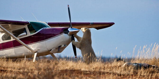
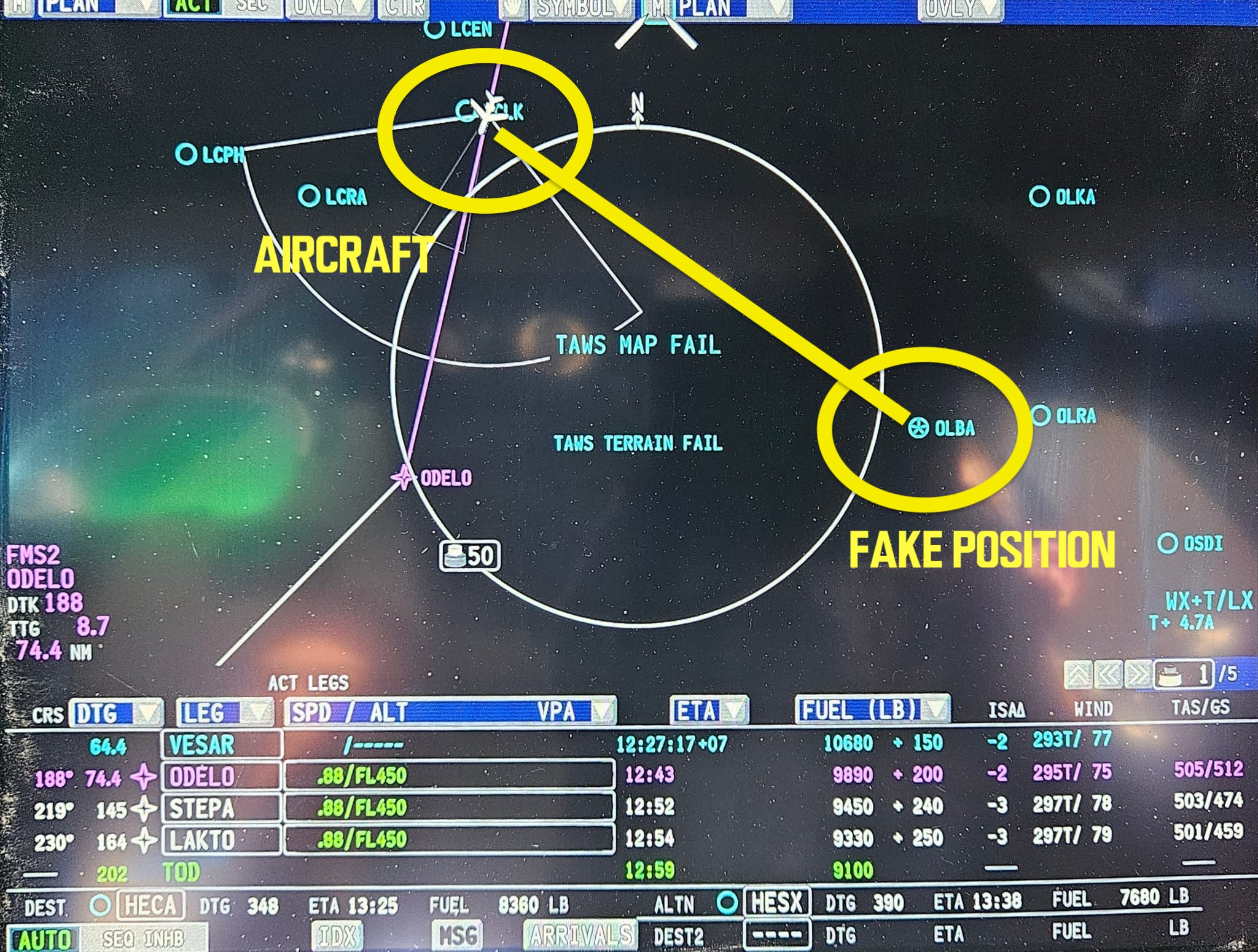
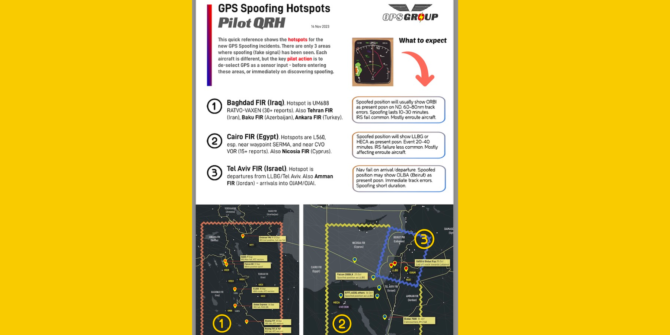
Canada, the (often) cold and (parts of it) remote northern neighbour to the US. 

We thought we would take a little look at what is available out there, should you find yourself anywhere north of Highway 16 (above N54°).

Why N54°?

Well, because there is not much north of it. Or rather, there is a whole lot of country but not many options north of it. The main cities (and airports) in Canada are primarily in the southern region, close to the US/Canada border.

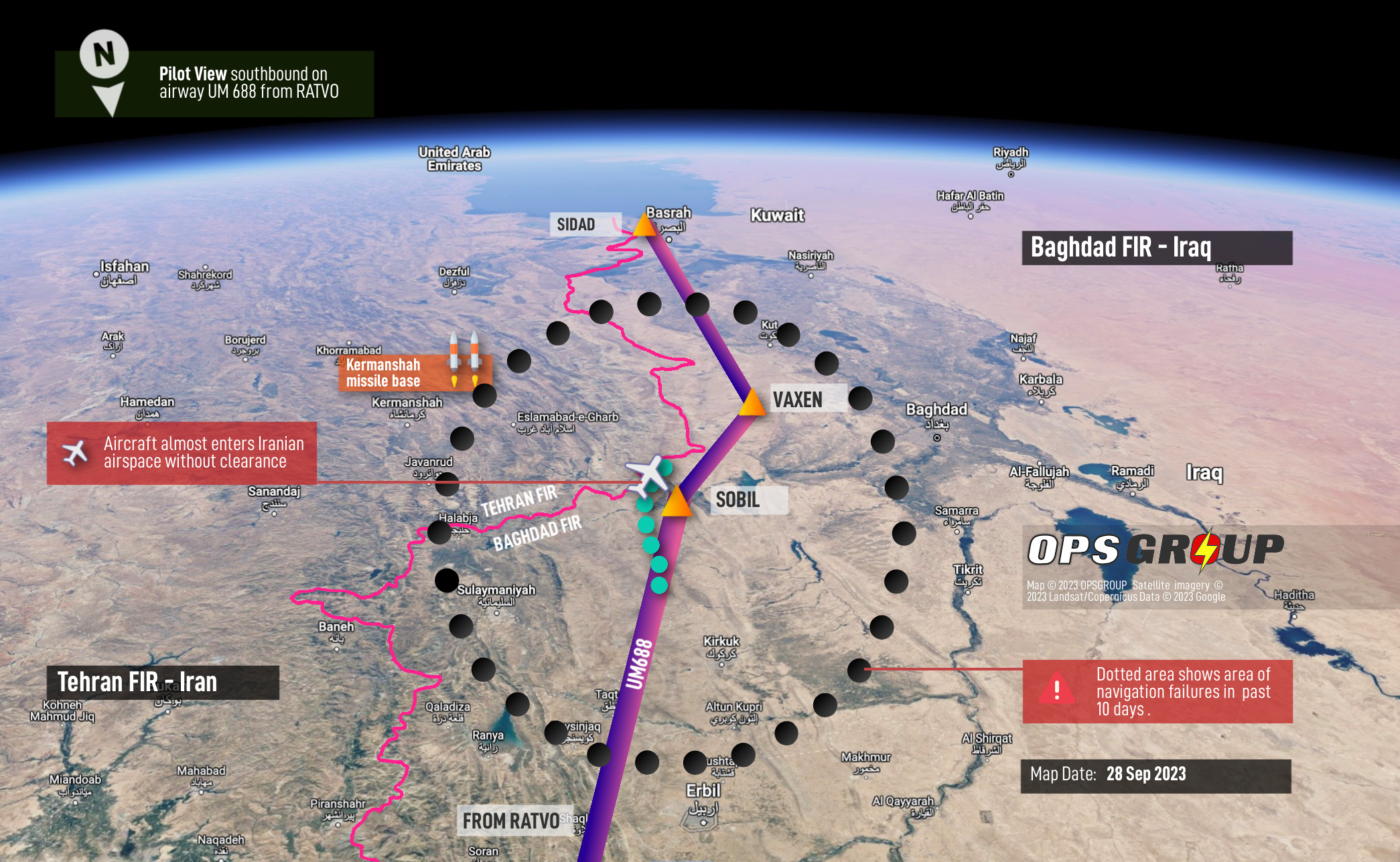
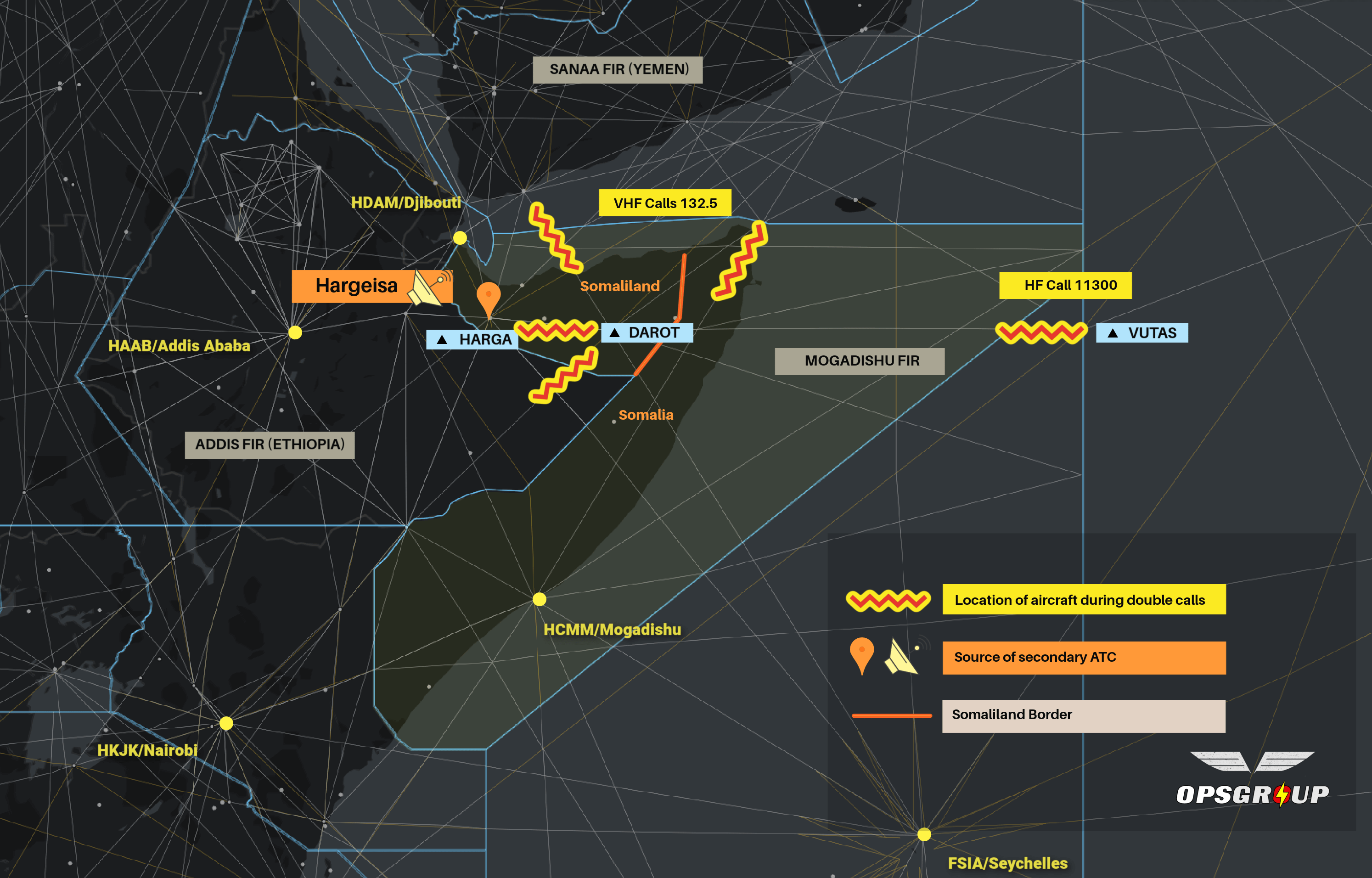
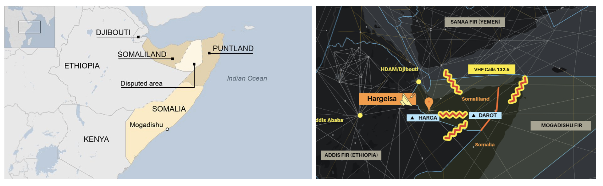
Here is a picture, because a picture speaks a thousand words. Or in this case, speaks about 10 airports…
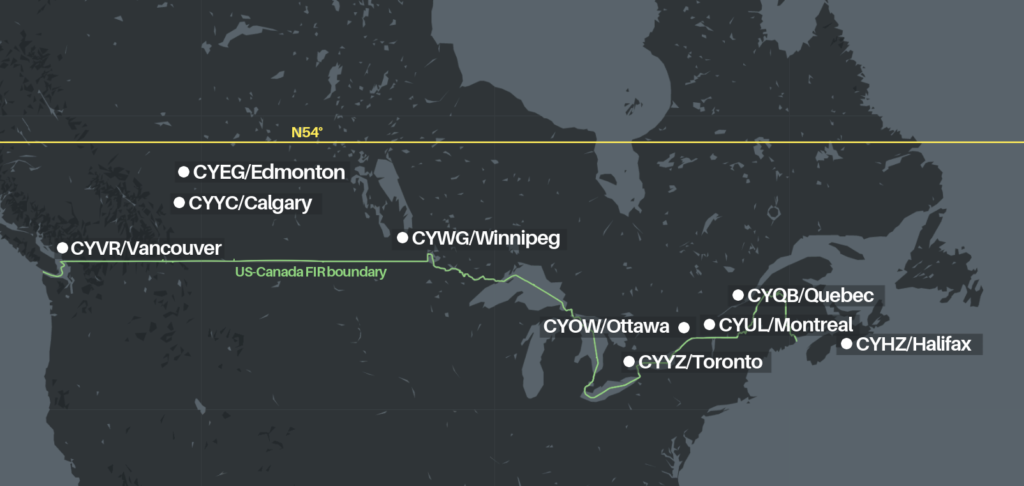
Canada is big. Very big. And the main airports (big international ones) are generally all situated below N54°. There are others out there though. The most northerly airport which receives scheduled passenger airlines services is CYRB/Resolute Bay sitting right up at N74°.

Unless you are actually operating into somewhere in the outer fringes of Canada then it is unlikely you will be routing over this region. Most polar routes bring you down across central eastern Canada and are unlikely to go so far west for the very reason there are very few airports available there if you need them.
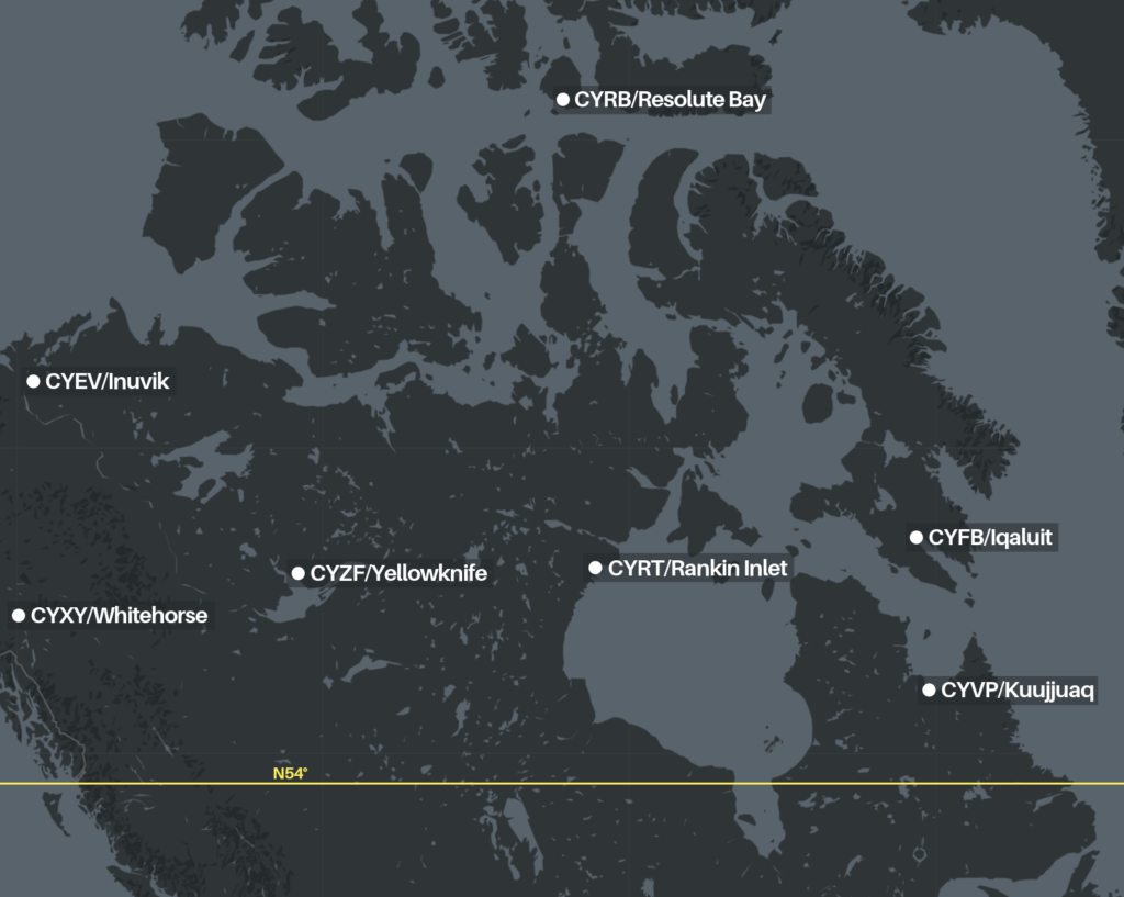
CYRB/Resolute Bay

This has a 6504’ runway 17/35 (that’s orientated to True North, FYI). Watch out though – it’s a gravel runway, so only really useful in a dire emergency!

There is an ILS to runway 35, an RNAV (GNSS) for runway 17, and a warning for severe turbulence during strong easterly winds. Probably something to do with the airport sitting on the edge of a craggy outcrop with lumpy, bumpy terrain to its east. Aside from the (cold) weather warnings, this airport also suffers from WAAS outages.

CYFB/Iqaluit

If you are up as high as this, and around the eastern region, you are probably better checking out CYFB/Iqaluit. This is often used as a planning airport for en-route diversions during polar and northerly North Atlantic crossings.

Runway 16/34 is 8605’ with an ILS to 34 and an RNAV to 16. Land on 16 and you have a few nice runway exits. Land on 34 and you’ll be doing a 180. It is an RFF 5.

There are a lot of ‘CAUTION’ notes on the airport chart here. Caution a steady green laser light, radiosonde balloons, terrain near the airport, large animals, wind that swings all over the place, a nearby blasting area, a random 2.5° ILS slope…

When the wind is from the north you can expect ok weather, if it is from the south the weather is less good, and this is particularly the case in Spring and Fall.

The charts suggest limited winter maintenance, but folk who have operated there say the maintenance is good.

So this is a good airport for emergencies, but has challenges of its own.

The main FBO is Frobisher Bay Touchdown Services who you can reach on +1 867 979 6226 / land@cyfb.ca / 123.350

CYVP/Kuujjuaq

Another eastern option. Runway 07/25 is 6000’ with an ILS to 07 and an RNAV to 25, and a VOR backup. There is a second gravel runway 13/31 which is 5001’.

The challenging environment means there are a few gotchas here too. Runway 07/25 has poor drainage and there is a risk of hydroplaning. It also has large animals in the airport perimeter (not sure if this means moose, bears or polar bears. Probably Caribou though), radiosonde balloons and seaplane activity on a nearby lake.

They say winter maintenance is limited, but this is because they do not operate 24/7. A few hours notice and they can clear the runway, and be available if needed though.

Talk to Halutik Enterprises if you are planning on planning this airport +1 819 964 2978 / cgadbois@makivik.org or try the airport direct on +1 819 964 2968 / 122.2

So CYFB/Iqaluit and CYVP/Kuujjuaq are your only paved runway options to the east.
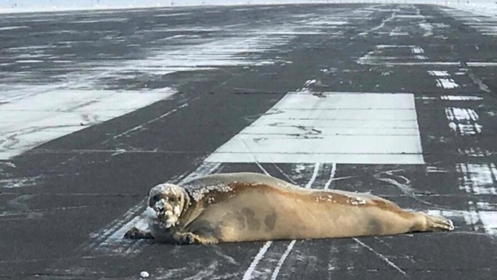
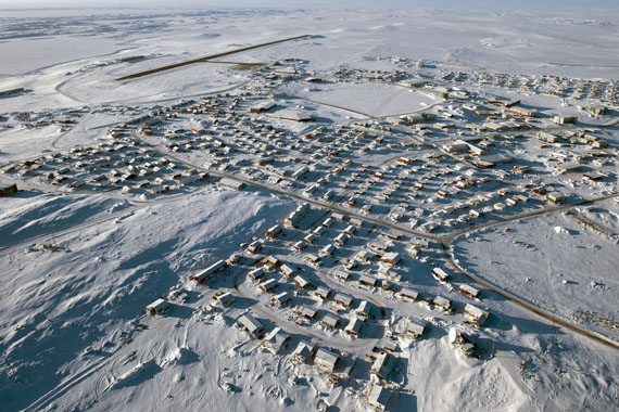
CYRT/Rankin Inlet

The only paved runway in the central region, this offers a 6000’ runway 13/31. Both approaches are RNAV (GNSS) and orientated to True North.

There isn’t much info on Rankin Inlet, but given the remoteness of the region you can probably assume limited ground support and harsh winter conditions but actually the services are very good and those harsh conditions are limited to the winter! Winds are a bit of an issue here at times – expect some strong, gusty crosswinds.

Check out the picture below…

The only FBO is the airport operator who you can reach on +1 867 645 2773 / +1 867 645 8200. yrtmaintainer@gmail.com might work too.

CYEV/Inuvik Mike Zubko

You have three paved options to the west.

First up, Mike Zubko. Mike, in case you’re wondering at the name, was a local aviator of note. Originally from Poland, he emigrated to Canada, became an Engineer with Canadian Pacific Airlines and went on to set up the Aklavik Flying Service, serving the remote region of the northwest corner of the North West Territories.

Anyway, the airport of his name has a 6001’ runway 06/25 with an ILS for 06 and an RNAV for 24. There are ‘limited graded areas’ outside the runway area here which basically means stay in the runway and you’re good.
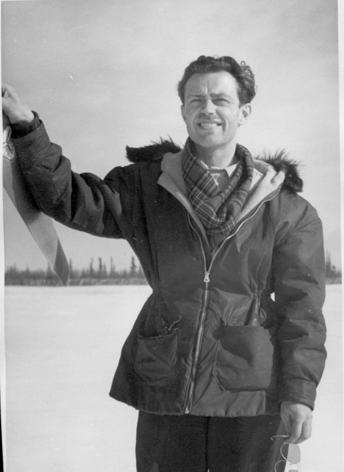
CYZF/Yellowknife 

You will find two runways here – 10/28 5001’ with  RNAV (RNP) approaches and 16/34 7503’ and offering an ILS to 34, or an RNAV (RNP). It is an RFF6 with 2 vehicles on call.

Yellowknife has limited winter maintenance (because of those operating hours again) and extensive bird activity but is a major hub in the area and will be able to provide ground support for most aircraft.

CYXY/Whitehorse

The biggest of the three, there are three runways here although 14R/32L at 9500’ and 14L/34R at 5317’ are the only two long enough for anything bigger than a short field Canadian Goose landing. 32L has an ILS,  14R has an RNAV. And actually there are no published approaches for 14L/32R let alone 02/20. This is an RFF5.

This airport is right in the middle of some pretty challenging terrain. Loads of it with an MSA rising up to 8500’ in the south. So you can expect some mean winds and a fairly challenging approach, missed approach and departure procedures.
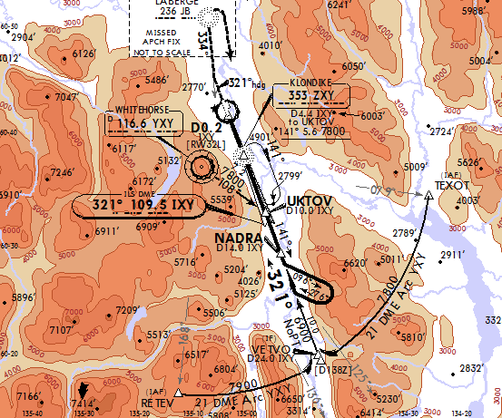
And we’ve been told about some others…

CYYQ/Churchill in the shores of Hudson Bay. The airport is not open 24 hours, but does boast a 9195′ runway with an ILS to 33 and an RNAV to 15.

This airport might look relatively small, but it sees high traffic numbers as the area is famed for ecotourism (great polar bear sightings) and it is also a primary transit hub for people and cargo travelling between Manitoba and the more remote regions. It can accept emergency diversions from up to Boeing 777 and 747 aircraft so a good option.

CYMM/Fort McMurray is a nice central international airport in Alberta used as a destination for narrow body aircraft, but a decent alternate for wide body aircraft with its 7503′ runway and ILS approach.

CYPR/Prince Rupert in BC has a 6000′ runway, and RNAV approach. There is limited taxiway and apron space here so a good emergency or diversion airport, but not much other support available and it has “limited winter maintenance”. The airport is on an island and weather observation is not done at the field so caution using this in poor weather.

CYXJ/Fort St. John also known as North Peace Regional is another BC airport option for emergency diversions. It has an unusual crossed runway layout, with 6909′ and 6698′ lengths. Runway 30 has an ILS, otherwise you’re looking at an RNAV. This airport is also slightly higher elevation, sitting at 2280′.

CYXT/Northwest Terrace Regional has Dash-8 sized aircraft operating in. It offers a 7497′ runway with an ILS and a shorter 5371′ runway with RNAV approaches.There is high terrain here (the airport is in a valley) and it is not recommended to use unless familiar with the airport, and even then only during daylight hours. 

That’s your lot!

Unless someone knows about one we haven’t heard of? If you have, please share. Email us at news@ops.group. Someone, somewhere, someday might be out in the great Canadian wilderness in need of an airport.


South Africa’s Unapproachable Approaches

South Africa is going through some troubled times on the aviation front right now. Fuel issues, power outages, and now, apparently, they are losing a whole load of their instrument approaches nationwide.

The Fuel Thing

Not as serious as their ‘fuel thing’ in 2022 (when floods disrupted the main transport line to FAOR/Johannesburg and they had severe jet fuel shortages for months).

This is limited to BP, who are to stop providing jet fuel at airports across the country. They’ve already withdrawn from FACT/Cape Town, and will do so at other main airports FAOR/Johannesburg and FALE/Durban from the end of April.

Shortages have also been occurring FABE/Port Elizabeth, FALE/King Shaka, FAEL/East London and FAUT/Mthatha.

So if you’re headed there, double-check with your local agent what alternative fuel suppliers are available, and what actual fuel is available for that matter.

The Power Thing

Load shedding is an ongoing issue. All airports have their own generators, so ops generally aren’t the issue. However, it is causing some concerns (again) for fuel.

Airlines have been tankering into FACT/Cape Town due to potential limits after the load shedding caused problems with the primary supplier.

There have been some Notams suggesting limited tower availability at some (generally smaller, regional) airports.

The Instrument Approach Thing

Authorities are suspending instrument approaches at a whole load of airports across the country. A check of South Africa’s Daily Airspace Plan shows issues with ILS, VOR, RNAV and GNSS approaches at various airports:

The reason for these suspensions is not yet clear, but seems to be related to an ICAO safety audit that is currently taking place – as most of the suspensions got published by Notam half-way through their visit.

What does this mean for operations?

It means you might want to see what is available at alternate airports, because many approaches might not be and that could turn out to be a nasty surprise for pilots.

Beyond that, it is not currently clear why they are being suspended – whether audit findings suggest safety issues, or if some are due to problems with power outages and intermittent signals.

If you have any information, please get in touch at news@ops.group


UK Air Passenger Duty Rate Hike

The UK Air Passenger Duty Rates are increasing!

What:

Air Passenger Duty rates – a charge for each passenger on flights originating in the UK.

Who:

It applies to fixed wing aircraft weighing 5,700 kg or more (12,500 lbs) and only applies to passengers you have onboard, not your crew. It applies to private non-revenue and charter flights too.

There are some exemptions:

  • Emergency, training, military, humanitarian, search-and-rescue and air ambulance flights
  • Cargo flights
  • Transit passengers possibly
  • Tech stops so long as no-one gets on or off
  • Not really an exemption, but if a passenger has an onward connecting flight it only looks a the first leg when deciding what to charge

There is also an ‘opposite exemption’ which applies to passengers on flights using aircraft of 20,001 kg (44,094 lbs) or more with fewer than 19 seats. For this they apply a premium rate which is in fact about double the standard business/first class rate.

When:

The new rates come in from April 1, 2023, and will be applied for the tax year 2023-2024. (So if you’re reading this post after March 31, 2024 then this probably won’t be accurate anymore.)

Where:

Everywhere in the UK.

They are based off where the journey ends outside of the UK. “This is their final destination”as HMRC state quite dramatically on their website.

How:

They are introducing new bands – specifically, a new domestic band and a new ultra long-haul band. Current rates will also increase.

  • The new domestic rate will be set at £6.50 (that’s actually been reduced from £13)
  • The new Ultra long-haul rate will start at £91

From April 1 there will be 4 (instead of the current 2) bands – Domestic, A, B and C.

Of course, it is the UK so never just that simple. There are also 3 types of rate, based off seat pitch:

  • Reduced: seat pitch less than 40″ (1.016m)
  • Standard: seat pitch more than 40″
  • Higher (the premium rate we mentioned earlier): airplane weighs 20 tonnes or more but has 19 or less seats.

If you go to this page you can see all the destinations and which band they fit into, as well as a lot of info on how to calculate your seat pitch and the rate you need to pay.

So the new ultra long-haul rate is the one that will really sting. This is for flights to countries whose capitals are over 5,500 miles from London, and so that includes key hubs like Bangkok, Hong Kong, Kuala Lumpur and Singapore, where the rate will now be as high as £601 per pax depending on how much leg room they have!

If you want more information then you can find it in several places:


13 things we learned this Winter

More specifically, 13 things we learned about GRF.

What is GRF? This is the Global Reporting Format for runway surface conditions. It came in back in Nov 2021, and if you have flown anywhere wintery since then, chances are you have encountered it.

The aim of GRF? To have one worldwide standard for how runway surface conditions are reported – to help make things a bit safer and reduce runway excursions.

In Feb 2023, EASA held a webinar which involved a load of updates for various wintery airports on how GRF was going.

We listened in to the webinar. Here are the 13 things we learned…

1. SPWR means Specially Prepared Winter Runway

And it seems to be quite EU specific (we haven’t seen it in ICAO docs).

What it means: An airport where the temperature is -15 degrees C or below, and which is covered in compacted snow or ice can be treated (usually with sand) to improve the friction characteristics (how well you’ll decelerate). When it is done properly (and checked and approved) then authorities will designate it an SPWR and it will be rated RWYCC 4 (or possibly 3, but 4 is probably what you need in order to land on it).

CC stands for condition code, 4 stands for a pilot braking action of good to medium, and an observed braking deceleration or directional control of good to medium on the runway condition assessment matrix.

2. Norway approved a bunch of airports for SPWR

It wasn’t easy, but they did it. The approvals were only temporary (most expire at the end of the Winter season in April/May 2023), but still, well done Norway.

What it means: You can expect more and more SPWR spots in winter zones.

3. The ATIS reports at airports giving GRFs can be really, really long.

What it means: If a runway was contaminated and then becomes Dry or Wet (so not contaminated anymore), they don’t necessarily cancel out the earlier report, which means all the info is going to be on the ATIS and that makes it really long (that’s what Norway said).

They are working on it. Trouble is, the other options are SNOWTAMs (these work, but how do you get an up-to-date one when you need it?) or ATC (clogs up the radio).

So for now, if you head somewhere wintery you can probably expect a pretty lengthy ATIS.


That was the top 3 things we learned. Here’s some more…

4. It isn’t easy for airports to be approved for SPWRs.

To get approval you need data, and to get data you need folk to be landing on the runway. But to land on the runway while it is treated you need approval…

What it means: You might still find yourself flying to airports next winter which don’t have their approval fully sorted. They issue temporary approvals, but until the data is in there may be some ‘uncertainty’ about the braking and directional control characteristics. But Norway got some done this year. Folk landed on them. It all went ok.

If you aren’t sure, talk to the airport authority to find out what they have, what they will report and what it means for you.

5. There is an airport in Norway called ENHV/Hooningsvåg

And it gets real wintery there.

What it means: 50% of landings in winter are on a contaminated runway, and the other 50% are on an SPWR. Oh, and their ‘winter season’ can be 50% of the year long. The same actually goes for a lot of airports in the upper latitudes so be prepared for winter ops and GRF if you head up there.

5. They are 95% confident in their GRFings.

What it means: GRF works, even on SPWRs. Which is lucky because, according to Ronny Anderson:

OK, let’s see what folk outside of Norway have to say…

7: Switzerland also have a lot of runways using GRF.

19 in fact.

What it means: Well, they probably have long ATIS-es too. But also, GRF is supposed to be Global but we seem to be seeing it used predominantly at winter airports. Hmm…

8. Spain use it too!

They have 46 airports, and only experience what they call ‘soft’ winters – basically snow and ice isn’t that common, and actually rain is the biggest issue. In fact, only 20 of their aerodromes even have a snow plan.

What it means: They are probably pretty unfamiliar with handling snow and ice when it does occur… but also that GRF should be used anywhere you find runway contamination, which can mean rain too!

9. According to Spain, GRF doesn’t actually work very well for rain.

What it means: It means they discovered a bit of an issue with GRF when it comes to watery measurements… If there is 3mm or less of water then it is considered wet and the RWYCC is 5, but add just 1 more mm of water and you are in the standing water category and now the RWYCC drops to a 2.

Which is a problem? They think so, because measuring to that level of precision is difficult, detecting big changes quickly is difficult, and when they try it generally messes with their runway capacity because, presumably, guys are having to go and wade about the runway trying to measure a 1mm change in water level.

What that means: There is no solution right now that is entirely excellent, so there is a level of ‘subjective’ in the GRF you might experience when flying into wet runways anywhere in the world in fact (and you don’t want to be the first to discover that code 5 is actually a code 2 so be careful when hearing ATIS-es that talk about standing water).

Let’s hear something positive again…

10. Germany consider their GRF implementation a total success.

We say Germany, actually we’re talking about EDDL/Dusseldorf.

What it means: Well done them! We shall expect perfect runway condition reports whenever we operate there.

What are operators saying?

11. Crews need to understand the GRF works in runway thirds.

That means you use the lowest of the RWYCCs, you should check how much of the first third of the runway is ‘flared’ over, and should shorten the runway by a third if there is an RWYCC outlier (but always use an outlier crosswind).

What it means: Well, trying to calculate takeoff performance using GRF is not always easy because we don’t tend to work in runway thirds for it, and it isn’t necessarily clear how much ‘conservatism’ should be applied.

And then there is the fact you might only get an updated report just prior to takeoff which means trying to rework all your calculations under pressure.

What that means: There is probably some training to do with your crew if they aren’t totally familiar with GRF, and you should make sure what you put in your company manuals is clear and answers all these questions so they aren’t rolling down the runway thinking “Is this actually ok?”

12. Because GRF considers braking deceleration and directional control, it isn’t just the contaminant or surface condition that impacts this.

Downgrade and upgrade criteria need to be defined to include things like wind speed, precipitation, temperatures, various vehicle behaviours, etc etc.

Which means: If you operate in somewhere you need to really do your part reporting back. This has been in for a couple of years, but there are still some creases (ice ridges if you like) that need ironing out.

And don’t assume it is all spot on and a runway excursion will no longer be a possibility at a GRF using airport. This is a tool for improving safety only.

The 13th thing we learned about GRF:

We need to read up on it a bit more. If you do too, then here are some links: