Palm Beach TFRs: The President’s Back In Town

Key Points
  • During President Trump’s second term, TFRs will periodically be activated over KPBI/Palm Beach.
  • Two rings will apply – a 10nm inner ring, and a 10-30nm outer ring.
  • Aircraft wishing to operate inside the inner ring (all KPBI departures and arrivals) will require TSA pre-screening. Inbound aircraft must depart one of five gateway airports.
  • The 10 – 30nm ring will only be available to aircraft operating in and out of local airports but will not require pre-screening.
  • These restrictions will only apply when activated by NOTAM.
  • A local TFR request form is only required for utility aircraft required to ‘loiter’ in the TFR such as aerial survey, banner and ag-aircraft. 

Home-sweet-home

The start of President Trump’s second term in the White House also means a return of a TFRs over KPBI/Palm Beach and Southern Florida.

The Mar-a-Lago Estate has been his primary residence since 2019 – a little over 5nm east of the field. Which means that whenever he comes and goes, operations will be heavily disrupted at the airport.

The FAA has published a reminder of procedures for when the presidential TFRs are active. Here is a brief summary of what you need to know.

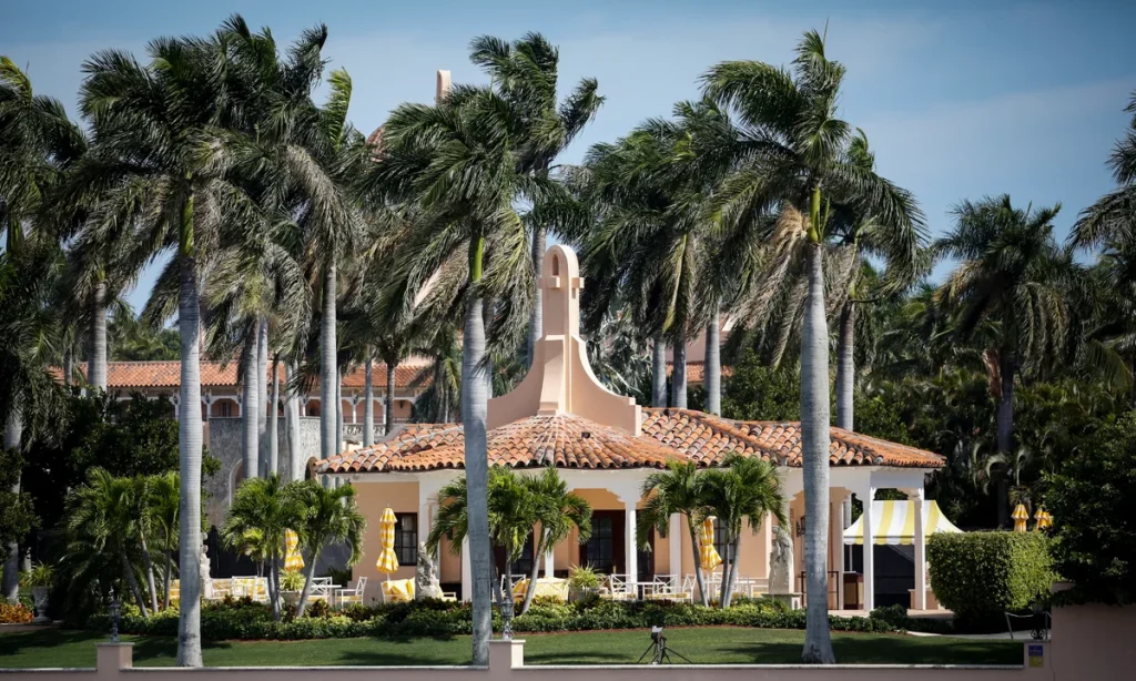
The Mar-a-Lago residence, not far from KPBI.
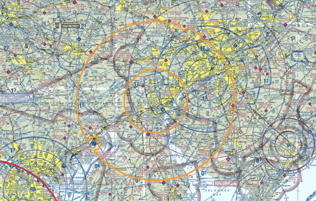
Flight Restrictions

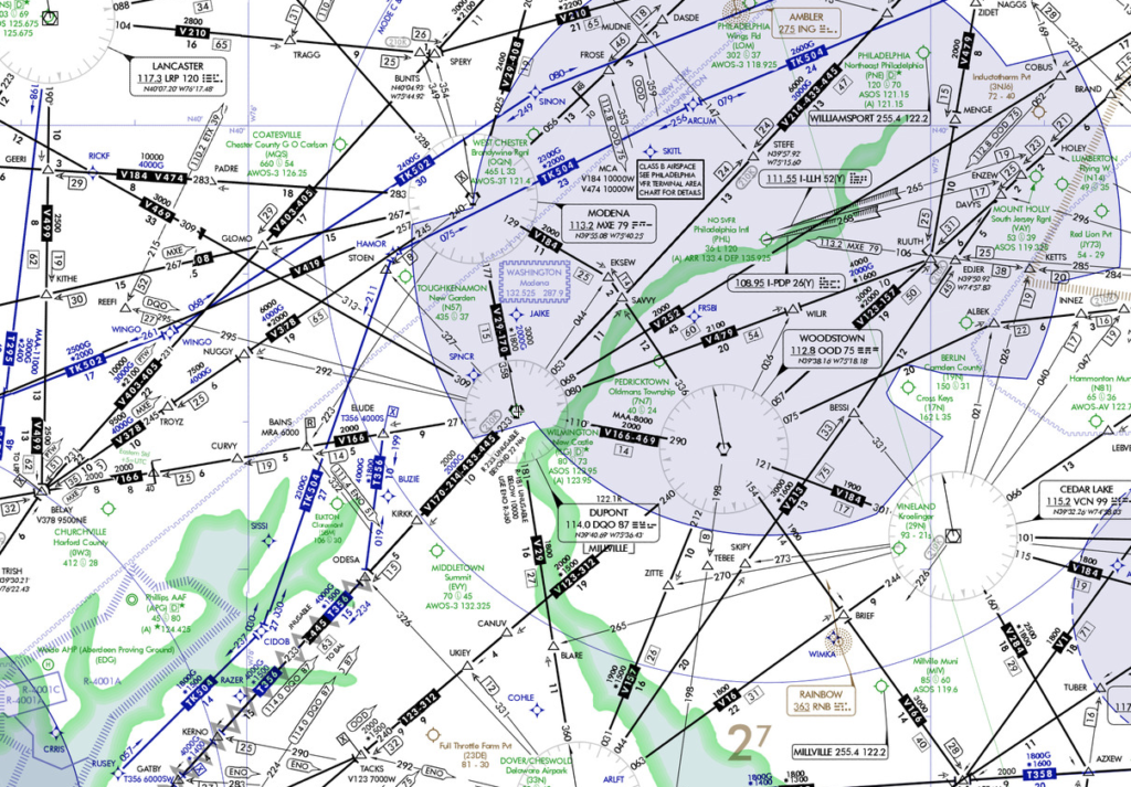
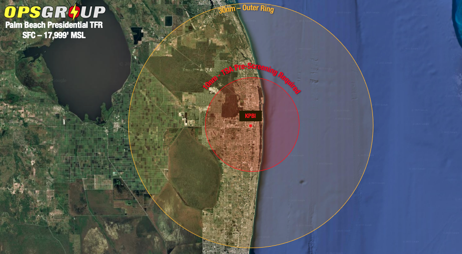
The Presidential TFR is comprised of two rings, centered on KPBI airport. 

The FAA has warned operators that TFR activation will be unpredictable in frequency and duration, so make sure you continue to check the current NOTAMs.

The Inner Ring (Most Restrictive)

A 10nm radius applies and extends from surface to 17,999’ MSL.

When active, all aircraft in and out of KPBI/Palm Beach will require TSA pre-screening. Once complete, aircraft details will be broadcast over the FAA Domestic Events Network – which includes all ARTCCs and various other Federal agencies.

For departures, this is available at the following FBOs between 0800 and 1700 local: Atlantic, Jet, Net Jets and Signature.

For arrivals, you will need to depart from one of the following five gateway airports:

  • KHPN/White Plains 
  • KTEB/Teterboro
  • KIAD/Washington Dulles
  • KMCO/Orlando
  • KFLL/Fort Lauderdale

Once pre-screened, intermediate stops are not allowed unless you have a bona-fide emergency.

In both cases you’ll need to register for screening at least 24 hours before your departure. Reservations are available by calling 561-616-9650.

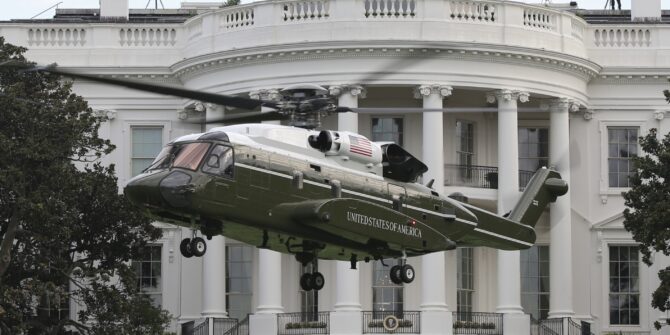
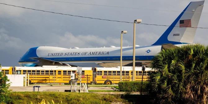
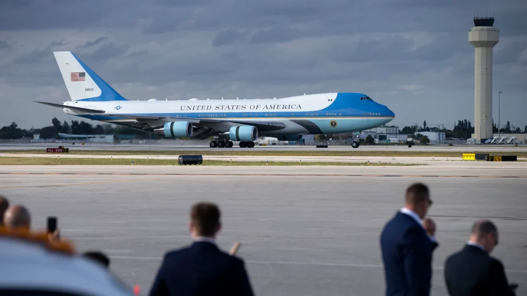
Air Force One Inbound

If you happen to be on the field when the President arrives, a ramp freeze will be enforced starting from seven minutes (or so) prior to his arrival.

A security inspection will be carried out on the runway after which it will be kept clear.

Once he (or any other VIP) has left the airport, the freeze will be…well, defrosted, and normal ops will resume – albeit Air Force 1 itself will remain under heavy security.

An important note from the FAA that’s easy to miss! If a pre-screened aircraft is holding for this process and reaches minimum or divert fuel, let ATC know. They may be able to get you special permission to land, but it’s not a guarantee.

Consider extra holding fuel if arriving during an active TFR. For obvious reasons, his precise arrival and departure times will not be made publicly available.

A ramp freeze will apply during the President’s arrival/departure during the TFR window. Expect some holding!

Outer Ring (less restrictive)

The outer ring extends from 10 to 30nm from PBI airport, from surface to 17,999’ MSL.

TSA pre-screening is not required, however only aircraft arriving or departing local airfields will be allowed. If things are really quiet, a transit clearance may be granted by ATC. However, any ‘loitering’ or other such tomfoolery is not allowed.

Discrete Squawks 🦆

All aircraft inside either ring will be required to squawk a discrete code and maintain constant contact with ATC on VHF.

The friendly folk at PBI ATC have clarified the following:

  • Departing PBI – code will be allocated by clearance delivery.
  • Departing a satellite airport – call TRACON prior to departing on 561-684-9047 to request a squawk and departure frequency.
  • Arriving at a satellite airport – call ATC prior to entering the 30nm ring to obtain a code and get radar identified.

Or better yet, avoid the TFRs completely.

All sounds too hard?

Presidential TFRs will only be activated when the president is in town. At all other times it will be ops-normal at PBI and nearby airfields.

If you’re planning a trip here, it’s important you monitor the NOTAMs closely. The FAA endeavors to provide at least 72 hours’ notice. You can also check the TFR website here.

Asking for a friend, what do you do if intercepted?

Don’t panic. Talk to them in plain English on 121.5 and follow their instructions.

Notify ATC that you have been intercepted – expect a number to call when you’re back on terra firma.


Major US Rocket Launch Incoming

**Update: April 12, 02:00z**

The launch has been delayed. It will now take place on April 17, with back up days on April 18 – 23. The new launch window will be from 12:00 – 15:05z each day.

——-

On April 10, SpaceX is planning on test launching a prototype re-useable superheavy rocketStarship – from a launch facility in Southern Texas. The impact on the US NAS will be larger than most rocket launches due a reasonably high chance of failure of the ten million pound behemoth. Elon Musk himself has only given the launch a 50/50 shot of actually working. But he is ‘guaranteeing excitement’ either way.

The FAA are taking no chances, and on launch day several large hazard areas will be established for both liftoff, and subsequent reentry. This will impact coastal traffic over the Gulf of Mexico near the Texan coast, along with traffic in and out of Hawaii.

Let’s take a closer look.

Launch

Liftoff will take place from a facility in Boca Chica, on the coast of Southern Texas.

The official launch date is April 10, with April 11 and 12 standing by as back ups. The action will take place between 12:00z and 16:00z (07:00 – 11:00am LT) each day.

In addition to a TFR extending 12nm off the coast from the launch site itself, for the ascent there will be two large hazard areas established well out into the Gulf of Mexico protected by Altitude Reservations.

Several airways off the coast will be impacted – primarily for those running north and south between the mainland US and Southern Mexico. Major ones include L207, L208, A766, A770, L214, and L333 impacting boundary waypoints IPSEV, DUTNA, KEHLI, IRDOV and PISAD between the KZHU/Houston Oceanic and MMFR/Mexico FIRs.

The good news for east/westbound traffic is that the hazard areas are fairly narrow, which means for the most part those published tracks will avoid the worst of the disruptions.

Additional congestion will be felt on alternative routes  – especially for aircraft transiting to and from Florida’s airspace via waypoint CANOA, and inland of the Texan Coast.

Reentry

Because this is simply a test flight, the rocket will reenter again on the same day as the launch, this time affecting Hawaii.

The reentry window is set for 13:10 – 17:45z (03:10 – 07:45 LT), with a hazard area established in a line from just north of the island group, extending well west into the Pacific.

Three airways connecting to the mainland US will be affected – A331, R463, R464 with transitions via waypoints ZIGIE, APACK and BITTA. There is also a Guam-bound airway to the west that will be impacted – A450 via the transition BRIUN.

Mission Accomplished

Once the mission is complete, the airspace will be returned to the US NAS and we’ll be back to ops normal. Likewise if the mission is scrubbed, the airspace will be opened up again and the launch rolled over to back up days.

If you’re tired of space related disruptions, we feel you. In fact it is a growing issue now that we’re having to share the skies with competing interests. We wrote an article on that very issue, which you may find an interesting read.

For more on this upcoming launch, see the official FAA briefing here.


The POTUS TFR is a NO TO US

Most US folk are going to be fairly familiar with TFRs, particularly those in place due the President, but we thought we would do a little recap on the one for Wilmington, Delaware because of where it lies and the impact it has on the surrounding airspace – or rather, the traffic flow which you might find yourself in.

What is a Presidential TFR?

For those not familiar, a Temporary Flight Restriction is activated, for security reasons, in airspace that the President of the United States will be flying into. The TFR area is typically made up of two rings with a smaller one of about 10-12 nautical miles and a larger going out to about 30 nautical miles. Generally, General Aviation is restricted to not below 18,000’.

The reason for GA flights bearing the brunt of the ‘no go’ is because of TSA screening, or rather the lack of, and the security implications this may have. 

You can find info on all current and active TFRs on the FAA website site here. They include the type, dimensions, times and any specific info and guidance, as well as handy visuals.

Why are we talking about this one in particular?

The current US President has a private residence in Wilmington, Delaware, which means there are probably going to be a fair few TFRs activated in the area for when he flies in and out. The previous President caused a similar disruption around the Palm Beach area.

This particular one encompasses an airport – KILG/New Castle airport – in its inner ring which is often frequented by General Aviation folk. Thankfully, they have agreed to change up the usual no-go restrictions and continue to allow access to the airport even during times of Presidential presence.

New Castle’s new restrictions

OK, not new, since this TFR has been in place for a while now. But in case you don’t know, and do want to go, here is a refresher on the regulations:

  • If you are GA and want to just transit the inner ring then no can do while it is active.
  • You will be prohibited from operating to KILG/New Castle and N57/New Garden airports while the TFR is active unless you have prearranged TSA screening at a gateway airport (or TSA screening for departures) at least 24 hours in advance
    • KIAD/Washington Dulles and KABE/Lehigh Valley are your current gateway options.
  • Some departures and approaches to KEVY/Summit Airport might be affected during TFR active times.

Here is an AOPA article on the gateway airports for this TFR.

Bigger route restrictions

There are some pretty major routes along the east coast affected while the TFR is active as well though.

  • The standard JAIKE arrival into KTEB/Teterboro
  • South arrivals into KMMU/Morristown and KCDW/Caldwell

If you are operating up from Florida and the Caribbean then you have two re-route options available to you to avoid the restricted bits:

  • Deep Water Atlantic Route – via VIRST Y494 YAALE YETTI Y497 SUBBS CYN GXU RBV V249 METRO
  • Route through Cleveland Center – via ROD KLYNE Q29 JHW LVZ4 and/or SVM J70 JHW LVZ4

The deepwater route is the shorter option if you meet the “flying over deepwater” capability and requirements.

Operating around the DC Metros?

You’ll probably want to file a JERES J220 BIGEO MAGIO J70 LVZ LVZ4 route.

All re-routes for Jacksonville Center, Atlanta Center and Washington Center will be published on the FAA Current Re-routes webpage.

So far, all of this is a copy and paste of the NBAA info page

Which you can read here if you fancy seeing it in a slightly different font.

There is a reason we are bringing this all up now (which was also highlighted by the NBAA) though… Holiday Season Traffic.

Holiday Season Traffic

KTEB/Teterboro, KMMU/Morristown, KCDW/Caldwell, and the JAIKE arrival get busy during holiday season. As does Washington Center (which handles 50% of the Caribbean traffic flow from the South), Jacksonville Center and Atlanta Center. When the Presidential TFR is activated it can result in traffic being re-routed and the impact on general aviation can extend as far west as Cleveland Center airspace.

So checking when the TFR is active, knowing what re-routes to expect, and being aware that volume (and so disruption) is going to increase during the holiday season, might save your bacon, or at least prevent a nasty surprise.

We’ve also put together a post (thanks to the NBAA’s advice) on things to think about now that the Holiday’s are Coming which you can read here.

Need more info on TFRs?

The FAA created this handy guide which includes info on understanding TFRs, interception signals and even some trivia!


Red Sky at Night, Aviator’s Fright

Summer in the Northern Hemisphere means a few additional challenges for aviation, particularly in the USA – Hurricanes (which we wrote about here) and Wildfires.

You probably read ‘Hurricanes’ and think yeah, I get that, but fires?

Wildfires do pose a fairly major risk to aviation though, so we thought we’d take a quick look at what those risks might be and what the forecast is for the 2021 Wildfire season.

Too hot to handle.

Wildfires are prevalent across the US during the hotter summer months, typically running from May through October.

Looking back to previous years, California saw 13 fires in 2019, but over 30 major ones in both 2018 and 2017. The 2018 fires led to over 1.8 million acres of land being burned. 2020 saw the first ‘rain free’ February (in San Francisco) since 1864 and the drier months, and warmer spring resulted in some of the worst wildfires in California’s history. 

The outlook for 2021 is not much better. 

There have been extended dry periods with over 90% of the West now in drought conditions. There have also been record high temperatures in the Pacific Northwest, Northern Rockies and northern Great Basin with warmer than normal conditions forecast for the summer. Add to that an increase in lightening activity and you are left with a recipe for significant wildfire risk.

In fact, the figures so far for 2021 are already at a ten year high.

Where can you monitor the fires?

There are multiple sites which track and monitor wildfires. This is a particularly good one and will link to specific info on the major fires.

But the risk to aviation is often not from the fires themselves. The big hazards comes from:

  • Smoke
  • Increased traffic levels, diversions and ATC capacity
  • Changes to localized weather conditions.

Out of the frying pan and into the fire.

Major airports generally have good protection from wildfires, and are a distance away from areas which will readily burn. However, smaller and more remote airports may not and damage to infrastructure, or disruptions to ground transport has a knock on effect. Fires also lead to power outages which impact services at the airports.

The major hazard comes from smoke though, and this can cause significant disruptions through reduced visibility.

Smoke has been known to reduce visibility to around 200m. In 2005 all four major airports in Honduras closed because of limited visibility from wildfires. In 2010, the visibility at KBOI/Boise Municipal Airport reduced from 10 miles down to 1 3/4 miles in just 9 minutes after a shift in wind direction carried smoke from nearby wildfires into the airport vicinity.

KSFO/San Francisco has also experienced delays and cancellations due to smoke from nearby Butte Country wildfires.

While Sonoma Country airports faced multiple closures in 2019.

Then there is the reduced Air Quality.

The health hazard this poses to ground workers means airports may find themselves understaffed and reduced resources lead to reduced services, which lead to more disruptions for aircraft and operations.

The smoke hazard isn’t just at ground level.

In 2013, a NASA satellite captured images of smoke from Canadian and Colorado wildfires which extended over the North Atlantic, and in 2020 an aircraft diverted into CYYT/St John’s after smelling fumes in the flight deck which were attributed to wildfires (again in Colorado).

What’s cooking.

Disruptions at airports lead to increased traffic levels requiring ATC support for diversions.

Smaller, regional airports have less capability for dealing with the impact of nearby wildfires, and when small regional airports in areas like Oakland, San Jose, Silicon Valley which have a high density of private jet traffic close, this can mean a lot of diversions happening very suddenly, and where they go can becomes an issue.

In addition to diverting aircraft, there is the firefighting aircraft to factor in as well. They might operate low-level, but they are not small and they need to operate from somewhere and this is added pressure for ATC.

MD-10s and BAE 146s are commonly used. The world’s largest is a B747 Supertanker which can carry up to 19,600 US gallons of fire retardant or water.

TFR zones are set up for major fire zone areas to allow for safe movement of the firefighting aircraft. You can check these here.

Where there are fires, the risks of incidents increases and between 2000 and 2013 there were 298 wildfire firefighter fatalities in the US. 26% of these were caused by ‘aviation associated’ activities which occurred across 41 separate events involving 42 firefighting aircraft. Three of these were midair collisions.

Pyromania.

Wildfires can impact the weather environment as well.

When large enough, Pyrocumulus cloud (also called Flammegenitus clouds) filled with rising ash and aerosols can build. These aerosols often carry a charge that increases the likelihood of lightning and with that an increased chance of fires spreading rapidly.

The “Station Fire’ of 2009, which burned more than 160,000 acres just outside of Los Angeles, also produced a convective column estimated to reach around 23,000 ft. Other majors fires have produced ones reaching as high as 40,000 ft.

These huge clouds are similar to cumulonimbus, only without rain. But they still contain significant up and downdrafts and can result in localized wind shear from gust fronts. The change in ground temperatures can result in significant thermals and large temperature gradients can result in significant localized vertical and horizontal winds.

There are ways to help.

Check those TFRs and check the wildfire maps. If you are operating into an area showing significant activity, consider how much busier ATC might be, and remember to check the capacity at your airport destination.

Report fires when you see them. Early notification of developing fires means the authorities can deal with them quicker, before they grow out of control.

Consider other ways to help. If you have an aircraft available, consider using it to help with evacuation flights. Airlines pulled together in 2016 following some major fires in Canada, and helped evacuate more than 80,000 residents. They also helped them bring their pets out safely. Be warned – you will have a tear in your eye after reading this one so open at your own risk!

The Forecast

There is a full seasonal outlook published here. But for a quicker summary of the 2021 Wildfire Forecast:

  • Alaska has ‘normal’ fire potential through summer and into the fall.
  • The Northwest is expected to experience significant and above average fire potential into September.
  • Northern California and Hawaii also have above normal significant fire potential expected.
  • Southern California will be at high risk through September (although this is ‘normal’ for the region).
  • The Northern Rockies region is expected to be above normal through August and September.
  • The Great Basin is expected to see increasing fire potential through August and possibly into September
  • The Southwest is expected to remain normal.
  • The Eastern Area is expected to be normal.
  • The Southern Area is expected to be below normal.

Wildfires pose a significant risk to aviation operations. They also pose a huge risk to those living there, the infrastructure and the economy. The Fire Fighter pilots are an extraordinary bunch of aviators and we wish them the best for this year.

There is a very interesting podcast available here if anyone wants to hear more about what their ‘Day at Work’ involves.