The North Atlantic Datalink Mandate – 2024 update

A period of temporary relief of the North Atlantic Datalink Mandate (NAT DLM) rules ended in Feb 2021. So since then, aircraft need to be CPDLC and ADS-C equipped to operate between FL290-410 throughout the NAT region.
Exceptions – areas where you DON’T need datalink
– Everything north of 80°North.
– New York Oceanic East FIR.
– Tango Routes T9 and T290. The other Tango routes (T213, T13, T16) all require datalink.
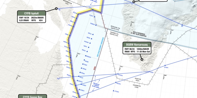
– GOTA airspace. We discovered this in Aug 2022, after some lengthy discussions with the authorities.
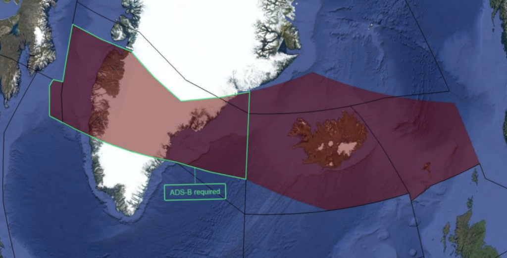
– ATS Surveillance airspace, where surveillance service is provided by means of radar and/or ADS-B, coupled with VHF. This includes the Azores, Bodo, and Iceland-Greenland corridor.
Tell me more about this “ATS Surveillance airspace”
This is a tricksy one.
NAT Doc 007 sets out the exempted ATS Surveillance airspace over Greenland and Iceland where you can still fly if you don’t have datalink (though if you don’t have it, you must have ADS-B!)
This area is bounded by the following:
Northern boundary: 65N000W – 67N010W – 69N020W – 68N030W – 67N040W – 69N050W – 69N060W – BOPUT.
Southern boundary: GUNPA (61N000W) – 61N007W – 6040N010W – RATSU (61N010W) – 61N020W – 63N030W – 6330N040W – 6330N050W – EMBOK.
Here’s how that looks:
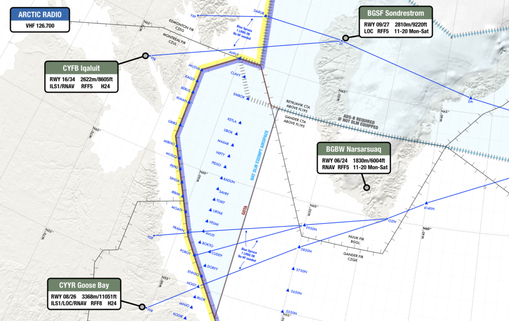
The southerly Blue Spruce routes
These go over Greenland linking Canada with Iceland via waypoint OZN, and are not fully contained in the exempted airspace. So if you’re flying these southerly Blue Spruce routes you will have to meet the NAT DLM requirements or fly outside of the vertical parameters of DLM airspace (i.e. below FL290 or above FL410). In other words: you need CPDLC and ADS-C to fly on the southerly Blue Spruce routes between FL290-410.
The northerly Blue Spruce routes
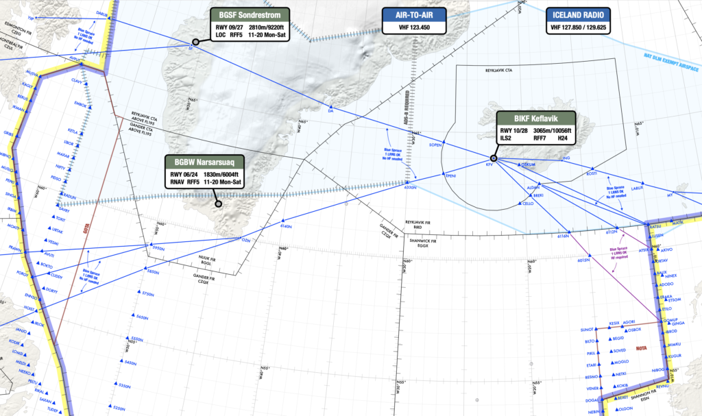
These are the ones going overhead BGSF/Sondrestrom airport. These do fall within the exempted area of airspace – so datalink is not mandatory if you’re flying here.
Only the northerly Blue Spruce routes are fully exempt from the NAT DLM.
Aircraft without datalink can request to climb/descend through datalink mandated airspace, but will only be considered on a “tactical basis” by ATC (i.e. you have to ask them on the day, and they’ll let you know, depending on how busy it is).
Flights that file STS/FFR, HOSP, HUM, MEDEVAC, SAR, or STATE in Field 18 of the FPL, are permitted to flight plan and fly through datalink mandated airspace, but may not get their requested flight levels.
For more details about the datalink mandate, check out the NAT Doc 007 in full here.
So, to recap…
- Datalink Airspace: Remember, NAT DLM airspace only applies from FL290-410. Below or above that, you don’t need datalink in the North Atlantic.
- If you have full datalink (CPDLC and ADS-C): You can go where you like. But watch out here – “full datalink” means you have Inmarsat or Iridium. HF datalink alone (ACARS) does not meet the satcom part of the NAT DLM requirement. So if you want to fly in NAT DLM airspace (FL290-410 in the NAT region) “J2” in field 10a of your FPL isn’t enough – you need “J5” for Inmarsat or “J7” for Iridium.
- For GOTA airspace: You need a transponder, automatic pressure-altitude reporting equipment and VHF. If you have ADS-B, that’s helpful for ATC.
- For the Blue Spruce Routes: You need datalink for the southerly ones, but not the northerly ones. (If you’re flying on these then you’re probably doing so below FL290 anyway, in which case you’re below NAT DLM airspace and don’t need datalink).
NAT FAQ: No Datalink, Where can we go?
If you don’t have datalink, this is how to make a crossing.