NAT Ops: Atlantic Thunder 22

Remember that big NAT military exercise a couple of years ago? And then the one that happened last year (Formidable Shield) around May time?

Well, now Atlantic Thunder is happening, which means once again large parts of North Atlantic airspace will be closed to all flights for several hours at a time.

Not quite as big as Formidable Shield though, but still big enough to have a conference about it.

The Conference.

They are holding one so you can find out exactly what the deal is.

Join it by visiting the Eurocontrol NOP page and find the link there under ‘latest news’. They have one before each of the days where the most impact is expected, so the first takes place on September 6th at 14:30 UTC (and then on the 8th and the 10th).

The Event itself.

Atlantic Thunder will take place from September 1-12, but the main exercise takes place on the Sep 7 (or Sep 9 or 11 if it doesn’t go ahead on Sep 7).

The official PDF issued by Shanwick is available here, and has lots of lists of everything closed and when…

We prefer pictures though.

So first up, danger area EGD701 

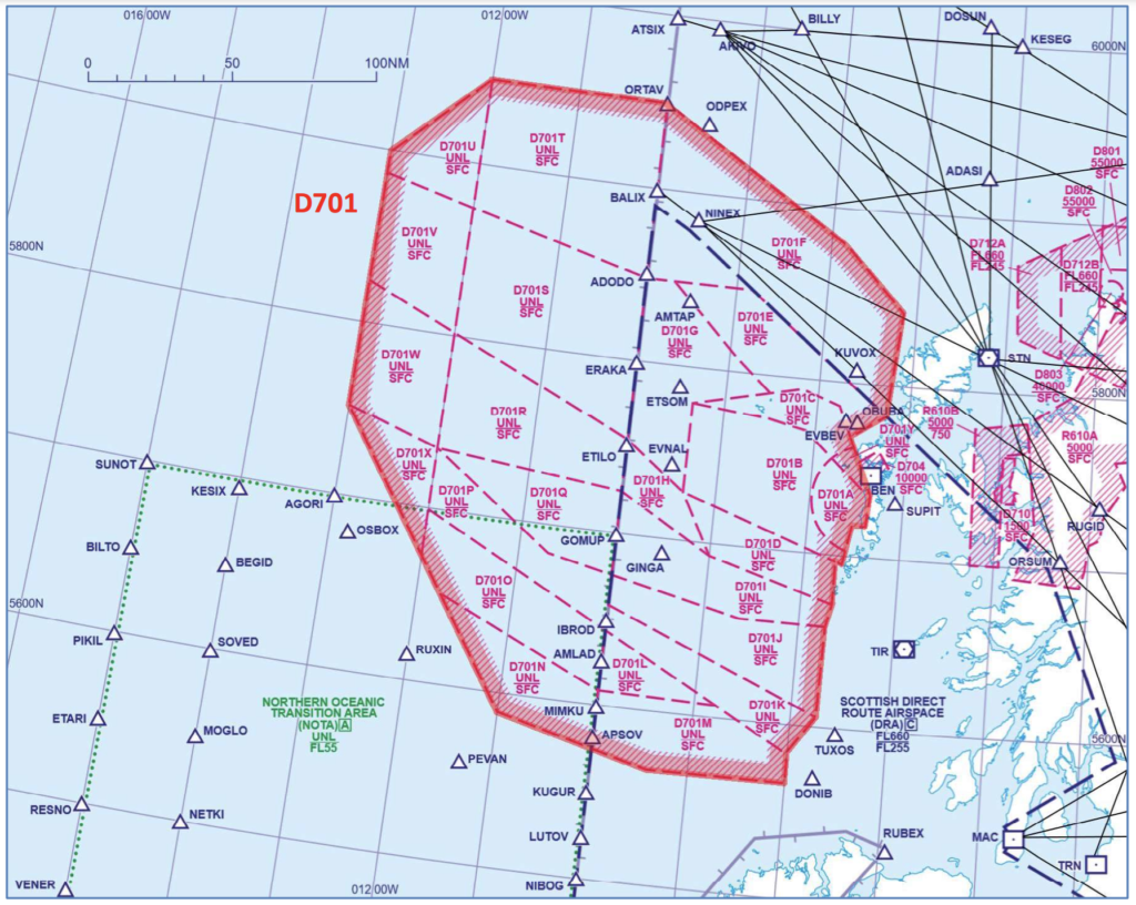
This area is tricksy because as you can see, it is made up of loads of smaller bits that can be activated at different times (and to different levels). They affect a bunch of the routes out of the NAT HLA, and potentially both the EGGX/Shanwick and EGPX/Scottish FIRs.

Initially it will be closed 1-6, and then on the 12th as well. The timings are annoying. Sometimes it is FL200, sometimes it is FL270, but then bits of it, between 1400-2359, are shut to FL UNL.

Like we said, tricksy.

But then…

But then there is Configuration 2 which involves the closure of EDG701 and also EGTHUN1 and EGTHUN2, which is a bigger area looking like this –
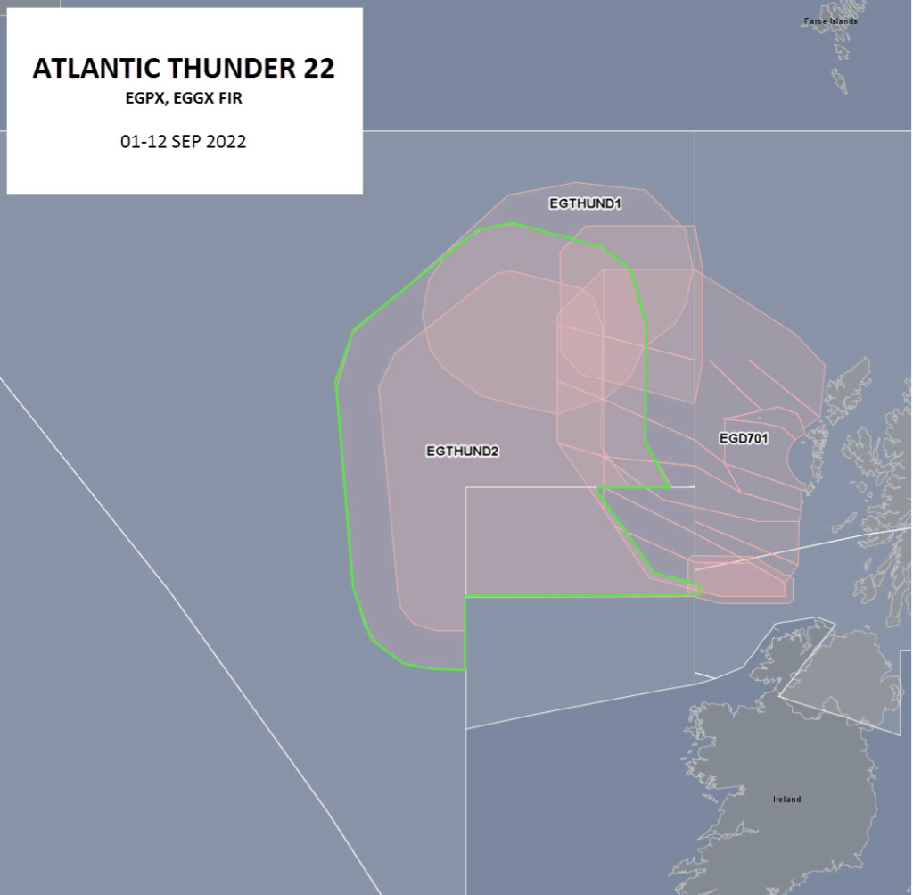
Configuration 2

Of course, they only publish the exact timings and configurations 24 hours in advance so you’re going to have to keep your eyes out for Notams and info on those.

Routing around the closed airspace.

Aeronautical Information Messages (AIM) will be issued prior to the start of each exercise, which will include suggested routings for flight planning around the closed areas.

Traffic overflying around these closed areas can expect to get 30NM separation if in NAT HLA airspace (FL285-420), or 60NM separation if flying at lower levels.


UK Free Route Airspace

December 2 has been a big day in the UK – it marks the biggest airspace change ever implemented in the United Kingdom.

A big portion of UK airspace is now free route airspace, and here’s what you need to know about it.

What is ‘free route’ airspace?

In ‘not free route airspace’ you are confined to what is effectively a motorway (freeway if you’re American) in the air – a big corridor, defined by points along it, and you follow these until you reach your junction ad turn off. It is rarely the most direct route.

Free route airspace allows you to route from a defined entry to a defined exit point direct. Straight through the fields if you like. It also allows more freedom for operators to fly the most time or fuel efficient route, taking into account weather.

The benefit is big.

That it is. 

The new airspace structure in the UK is expected to save around 500,000 nm a year of flying and that means a big reduction in CO2 – they are estimating around 12,000 tonnes a year.

Here is NATS own article on it.

Where is this airspace?

It is in northern UK and consists of 150,000 nm2 of airspace over the North Sea, Scotland, North Atlantic, Northern Ireland and a small portion of northern England – so within the Scottish UIR, London UIR and Shanwick OCA, and affecting the route network over some international waters. There will also be FRA in the London UIR within the region known as the PEMAK Triangle and TAKAS box.

This airspace accommodates up to 2000 flights a day and supports around 80% of transatlantic traffic.

The Free Route Airspace is H24 and between FL255-FL660.

You can find the full info on the relevant airspace here, including dimensions and how it links with other high seas airspace.

Where else is this happening?

You might want to take a look at the Free Route Airspace implementation taking place across the rest of Europe as well. This has been going on a little longer, and large areas of Europe already have it implemented.

They are also working on cross-border activities which may create even more direct routings in the future.

Norway’s AIC A03/21 published Oct 2021 provides info on the operations between the FRA in the Finland FIR, Copenhagen FIR, Polaris FIR, Riga FIR, Sweden FIR, Tallinn FIR (known as the NEFAB FRA meaning the North European Functional Airspace Block) and, of course, the Scottish FIR. These are known as the “Borealis Alliance”. (Here’s a link to the Borealis Alliance Presentation, if you want to find out more about the background and current stages of the overall project.)

Norway’s AIC tells us that flights routing through these airspaces will be eligible for Free Airspace Routings if they have a planned trajectory within the following vertical limits:

  • DK-SE FAB FRA FL285-FL660
  • NEFAB FRA FL095-FL660 (EETT/EFIN FIR FL095-FL660, EVRR FIR FL095-FL660, ENOR FIR FL135-FL660)
  • EGPX FRA (FL255-FL660)

Additionally, if you are routing to/from the UK FRA to the NEFAB FRA then you are going to have to file some intermediary waypoints because they have a lack of radar cover there. These Entry/Exit points are ATNAK, ALOTI, BEREP, GUNPA, KLONN, NINUN, ORVIK, PEPIN, PENUN, RIGVU.

There is additional information for flight planning in there so we recommend reading it through, and heading to the relevant ANSP for any of those countries if more info is needed.

Anything else to know?

While cross border operations are in place for much of it, the interface between Shanwick OAC and Reykjavik OAC will not change.