New features – Conflict Zone & Risk Database

To make it even easier to get a current risk picture for International Flight Ops, we’ve added a bunch of new features to the Conflict Zone & Risk Database at SafeAirspace.net.

Thank you to all OPSGROUP members – all our airlines, aircraft operators, pilots, dispatchers, and industry colleagues who’ve made this possible. Now we have a simple, single source of information for all risk warnings, analysis, that includes our Risk Radar project (so for the first time we can see what other operators are doing), all state warnings, and the ability to auto-generate a live Summary PDF of the current situation.

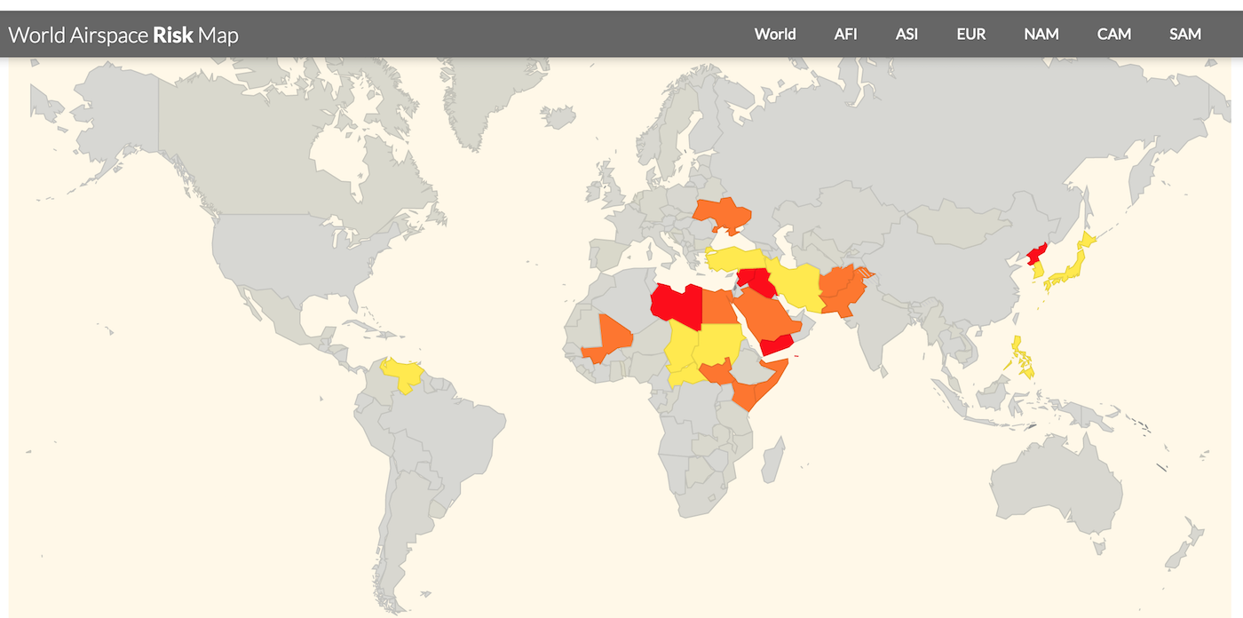
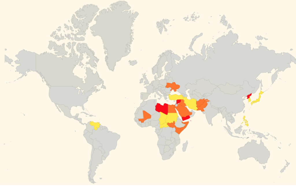
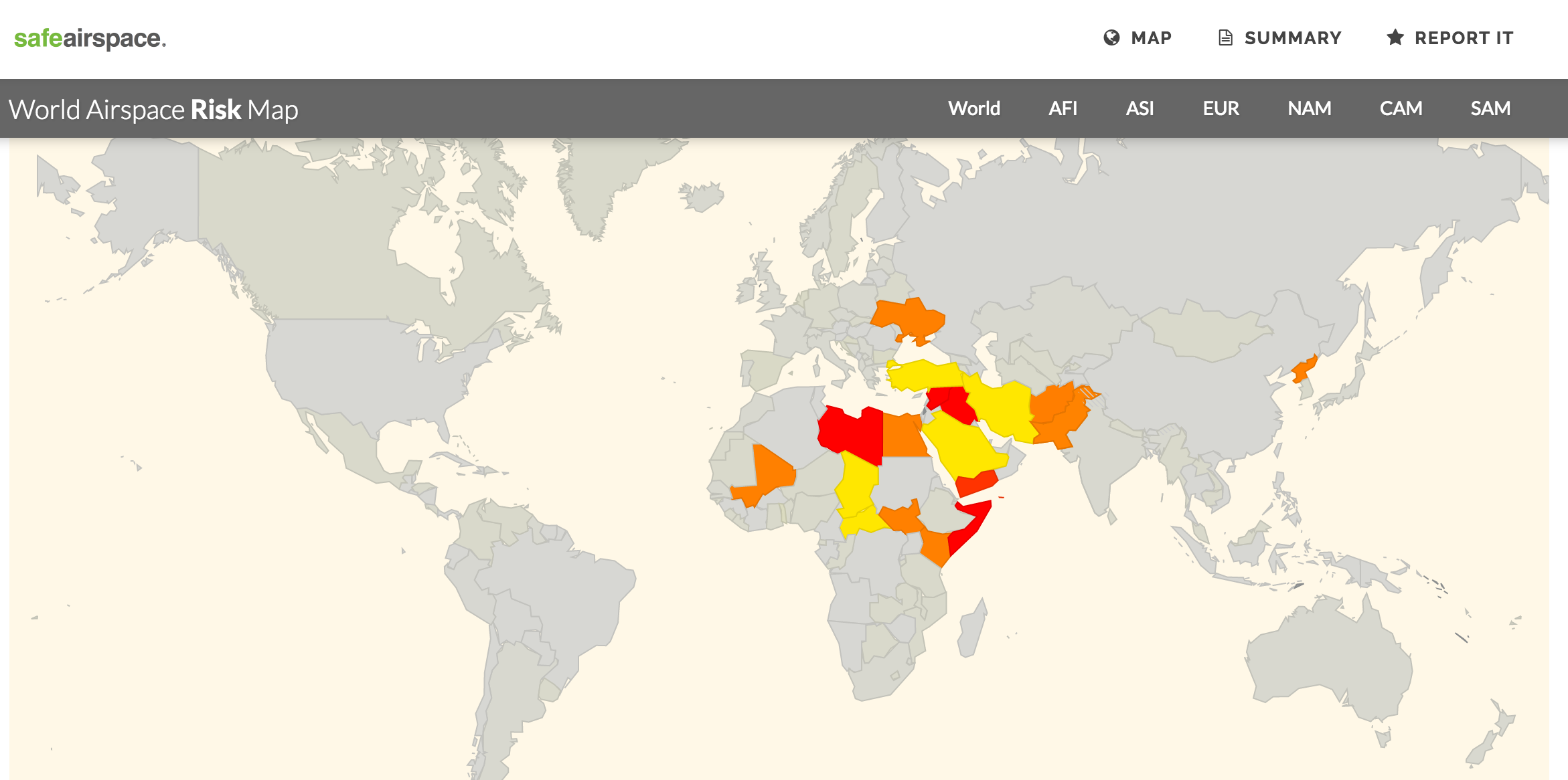
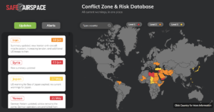
Start at SafeAirspace.net, where you have the current risk map, and feed of Updates and Alerts:

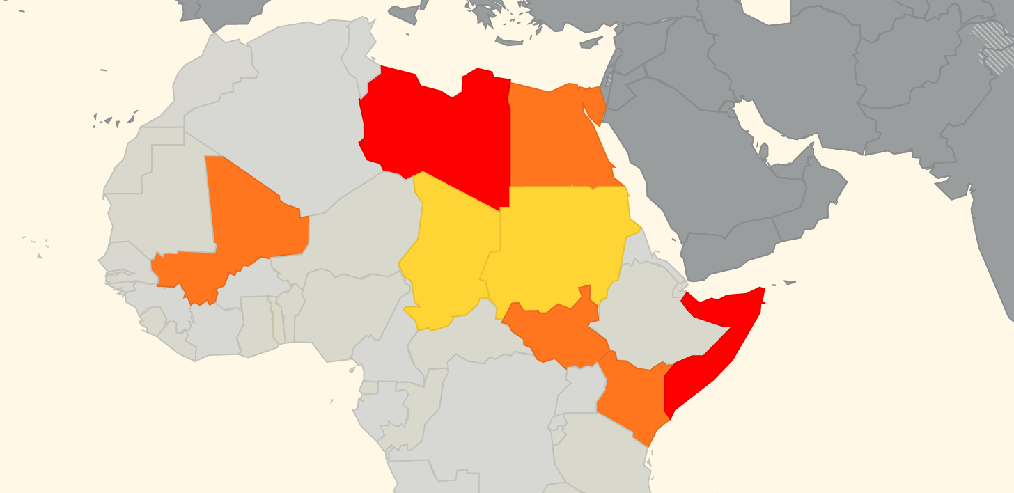
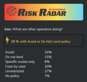
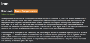
On each country page, you will now see Risk Radar information like this:

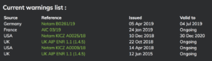
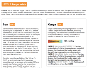
For each country, you’ll see the current list of warnings, both from the country concerned and other states:

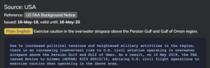
Scrolling down, you’ll get the current Notam/AIC/AIP reference and a copy of the text:

For each country, there is a Summary and Analysis, so you get some background on why these warnings exist:

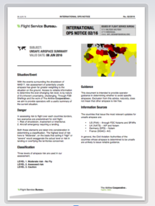
A new feature is the ability to generate a live summary into a PDF, so you can print out everything into one document to share with your crew, dispatchers, and security team:


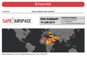
You can download an example of the PDF, generated on June 19th, 2019, here:

PDF Summary – World Airspace Risk at SafeAirspace.net


Download PDF, 800kb

You can generate your own live PDF here.

About the Conflict Zone & Risk Database

The Conflict Zone & Risk Database provides a single, independent, and eternally free resource for all airspace risk warnings, so that airlines and aircraft operators can easily see the current risk picture for unfamiliar airspace.

Safe Airspace is an initiative from OPSGROUP, an independent organisation with 5000 members, made up of airlines, corporate flight departments, private operators, charter operators, military, and government.

The Conflict Zone & Risk Database was launched in September 2016 as the lifespan of the ICAO CZIR was coming to a close, keeping the work ICAO did on the project alive, and providing the autonomous platform needed to make the concept work.

Objective – one single source

A single source for all risk warnings issued about an individual country, independent of any political or commercial motivation, so that a pilot, flight dispatcher, security department, or anyone responsible for flight safety can quickly and easily see the current risk picture.

Oversight and independence

The CZ&RD is managed by OPSGROUP. Because we are outside the chain of government, we are responsible only to our member airlines and aircraft operators, and more importantly, to the people ensuring a safe flight operation, and to the passengers that fly on our aircraft. For this reason, all information pertinent to a country can be assured to be carried here.

Eternally free

To remain completely independent of any bias, and to ensure that everybody has access, the Conflict Zone & Risk Database is completely free of charge. We have no commercial interest in publishing this information, it exists as a public service because our members care deeply about flight safety.

Contacting us

We rely on your input. If you have information to add, please email report@safeairspace.net. You can also use this address to discuss any content here. The collaborative effort is our focus. We’re still a team of humans, and we miss stuff. If you see something missing here, please tell us!

All submissions are anonymous, and our only concern is for the safety of all airspace users – the crew and the passengers. We appreciate your help.


European air traffic warned over Syria strikes

EASA are warning of possible air strikes into Syria being launched from locations within the LCCC/Nicosia FIR over the next 72 hours (Apr 11-14).

Eurocontrol have published a ‘Rapid Alert Notification’ on their website, with a statement from EASA that reads:

“Due to the possible launch of air strikes into Syria with air-to-ground and / or cruise missiles within the next 72 hours, and the possibility of intermittent disruption of radio navigation equipment, due consideration needs to be taken when planning flight operations in the Eastern Mediterranean / Nicosia FIR area.”

Very few commercial flights operate over Syria, and authorities in the US, UK, France and Germany have all previously issued warnings for Syrian airspace.

But many airlines regularly transit the LCCC/Nicosia FIR: there are frequent holiday flights to the main Cypriot airports of LCLK/Larnaca and LCPH/Paphos; overflight traffic from Europe to the likes of OLBA/Beirut, OJAI/Amman and LLBG/Tel Aviv; as well as traffic from Istanbul heading south to the Gulf and beyond.

Last year, two US warships in the eastern Mediterranean fired missiles at an air base in Syria after a chemical weapons attack by the Assad regime killed more than 80 people.

This week, following another suspected chemical attack by the Syrian government against civilians in a rebel-held town in Syria, the US President Donald Trump warned there would be a “forceful” response. On Apr 11, he took to Twitter to warn Russia to prepare for strike on Syria:

For the airstrikes on Syria last year, the US gave Russia advance warning of the attack, and Russian forces opted not to attempt to shoot down the missiles using its air defence systems stationed in the region.

However, this time round things could be very different. This week, Russia’s ambassador to Lebanon reminded the US that the head of the Russian military has said his forces in Syria would not only shoot down any missiles that threatened them but would target the source of the weapons as well.

The only US warship currently in the Mediterranean and capable of a possible strike is the USS Donald Cook, which left port in Larnaca and started to patrol in vicinity of Syria on Apr 9. According to some reports, it has since weighed anchor off Syrian territorial waters, and has been “buzzed” by low-flying Russian military jets.

Another 3 warships of the Sixth Fleet are already in the Atlantic Ocean, and on Apr 11 the entire US Truman Fleet (including an aircraft carrier, 6 destroyers, and nearly 6,500 sailors) departed Norfolk, Virginia, to head to the Mediterranean Sea. However, it may take up to a week for any of these warships to arrive.

Here’s an overview of US and coalition forces’ military options currently thought to be on offer in the eastern Mediterranean:

With the downing of MH17 by a surface-to-air missile over Ukraine in 2014, as well as all the recent unannounced missile tests by North Korea, there has been increased focus by the aviation community on the risks posed by conflict zones. If any missiles are launched from the Eastern Mediterranean in the next few days, be prepared for possible last-minute reroutes, as any Notams that get published may not give much warning.

Further reading:

One of our biggest missions in OPSGROUP is to share risk information and keep operators aware of the current threat picture. Check out Safeairspace for the most up-to-date information on airspace safety around the world.


New Unsafe Airspace Summary and Map

March 20, 2018: One of our biggest missions in OPSGROUP is to share risk information and keep operators aware of the current threat picture. The latest Unsafe Airspace Summary is now published, and available to members here as a PDF download (Unsafe Airspace Summary 20MAR2018, edition LIMA).

The main changes since the last summary are below. For a current risk map, refer to the Airspace Risk map in your member Dashboard.

The situation in Afghanistan remains similar. On March 13, Germany added wording to maintain FL330 or higher,  still recommending against landings at Afghan airports.

Germany also issued updated NOTAMs for Mali, Iraq, and South Sudan. All warnings remain as previous, unchanged from the prior NOTAMs.


What altitude is ‘safe enough’ to overfly a Conflict Zone?

Most conflict zone guidance from Aviation Authorities is based on the risk posed by MANPADS – Man Portable Air Defence Systems, or more descriptively – Shoulder Launched Surface to Air Missiles (SAMS).

Large-Unit SAM attacks on aircraft are uncommon – MH17, removed from the sky by a Russian-made Buk missile, was the first aircraft to be shot down by a large SAM unit since a Siberia Airlines Tupolev in 2001. These large units – requiring a radar system as part of the mechanism – have never been used by terrorists. Almost all incidences involving large-unit SAMs have involved misidentification. There is no safe altitude from a large SAM.

MANPADS, on the other hand, represent a greater threat to aircraft in 2017. These shoulder-launched systems are very portable, and far more likely to fall into the wrong hands. Common ranges are in the 10,000 – 15,000 ft range. The most dangerous is the FIM-92 Stinger, which has an operational ceiling of 26,000 ft (and there is concern that these have reached anti-government rebels in Syria)

The internationally promulgated standard safe altitude for overflight has now become about 25,000 ft AGL. Most CAA/State guidance is issued based on this number. There are two important points for aircraft operators to note:

    • That is 25,000 feet Above Ground Level. A missile could easily be launched from a mountain, or higher ground, so if you take 25,000 feet as your safety margin, make sure to add the terrain elevation beneath. In South Sudan, for example – Juba is at 2,000 feet – most of the country is at about this height. So 27,000 feet should be the minimum safe level, and you can work with FL270.
    • This is based on the assumption that we’re not worried about Stingers. Especially in the Middle East, a higher safe altitude might be better. FL300 seems like a good place to start.


References:


Updated airspace warnings for Egypt, South Sudan, North Korea

Germany has issued fresh warnings on the airspace of Egypt, South Sudan, and North Korea, in three separate Notams issued in the last week. Germany is one of four states that provides Aircraft Operators with conflict zone and risk advice. We have updated the SafeAirspace.net country information pages with the specifics.

The current Flight Service Bureau summary of each country follows:

Egypt Since the Arab Spring, Egypt’s stability and security situation as a state has declined. In October 2015 a Russian A321 was brought down over the Sinai peninsula by a bomb loaded at HESH/Sharm El Sheikh. In the aftermath, it was initially feared that a missile had caused the crash. Multiple warnings still in place from that fear. 19 May 2016 EgyptAir Flight MS804 from Paris to Cairo disappeared over the Mediterranean, cause unknown. GPS jamming reported at HECA/Cairo several times in 2016. High threat from terrorism in Egypt. Further attacks are likely. Not recommended as a tech stop. [Read full country information]

South Sudan Conflict Zone. South Sudanese Civil War since 2013. The security situation in Juba has been relatively calm since the July 2016 crisis. Daily reports of fighting throughout the rest of the country. The security situation is especially unstable in the Equatorias in the south. MANPADS risk to overflights. In addition, the South Sudanese army has declared intention to shoot down Aircraft without permits. Most Authority guidance recommends min FL260. We think FL300 is a better minimum for overflights. [Read full country information]

North Korea The level of tension on the Korean peninsula can change with little notice. Multiple missile launches in 2016, increasingly without prior notice to ICAO. The range of these has increased – previously safe airways B467 and G711 are now at risk. Over 1000 reports of GPS jamming issues reported by operators in the vicinity of the North/South Korean border. SFAR79 prevents US operators from operating west of 132E, other Authorities restrict operations east of that line. [Read full country information]


References:


New airspace warnings – Turkey, Iran

Today Flight Service Bureau has published ION05/16 – an updated Unsafe Airspace Summary, with new warnings for Turkey, and Iran, and a new map at safeairspace.net. This replaces 04/16 issued in August.

Turkey: 23SEP16 Germany B1289/16 Do not plan flights to LTAJ due potential ground to ground firing in the vicinity of LTAJ/Gaziantep Airport.

Iran: 09SEP16 FAA Notam KICZ 19/16 Exercise caution within Tehran FIR due military activity.

New information in the PDF is marked with a   I   beside it. Please distribute the PDF to anyone you like, we are keen to make sure as many operators as possible are aware of the risks.


opg-safeairspace


Unsafe Airspace – a summary

With the events surrounding the shootdown of MAS17, risk assessment of potentially unsafe airspace has given far greater weighting to the situation on the ground. Access to reliable information to determine the ever-changing risk level, is by nature of it’s inherent uncertainty, challenging.

Today we published International Ops Notice 02/16 – “Unsafe Airspace”.

Three levels of airspace risk are used in our assessment.

  • LEVEL 1. Moderate risk – No Fly
  • LEVEL 2. Assessed risk
  • LEVEL 3. Caution

The countries that issue the most relevant updates for unsafe airspace are:  The US (FAA) – through FDC Notams and SFARs, the UK (NATS) – AIP and Notam, Germany (DFS) – Notam, France (DGAC)- AIC. In general, the Civil Aviation Authorities of the countries whose airspace is determined to be unsafe are unlikely to issue reliable guidance.

Five countries are currently included in the LEVEL 1 – Moderate Risk category: Libya, Syria, Iraq, Somalia, and Yemen.

The basis for inclusion is the highly unstable current events on the ground, and in all cases the ground factions having access to RPG’s, Surface-Air missiles. We strongly recommend avoiding this airspace entirely. All countries have multiple warnings, and your country of registry is likely to have issued specific instructions not to penetrate these airspaces.

Download the full notice.

References:

ION0216 Shot