
It’s no surprise to most that the North Atlantic is the busiest oceanic airspace in the world. Before Covid came along and crashed the party, 1300 flights a day were crossing between the US and Europe alone. To keep things running smoothly there are a bunch of procedures to follow.
We write about them a lot, especially when they change. From time to time questions continue to pop up that make us scratch our heads. And so we thought this might be a good chance to share a few of those with you – naughty NAT conundrums if you will.
To SLOP or not to SLOP?
Chances are if you fly in oceanic airspace you already heard of Strategic Lateral Offset Procedures (SLOP). They’re pretty straightforward – you’re supposed to offset up to 2nm right of track without needing a clearance.
We do this because humans are fallible and mistakes can be made. Ironically the extreme accuracy of modern navigation systems mean that in the case of gross navigational errors, level busts or incorrect clearances, these systems actually increase the chance of a collision. So we pull over to the side of the road a little more, just in case.
Do we have to SLOP?
If you’re in the NAT HLA and your aircraft is capable then yes, it’s ‘required’ (as per ICAO NAT Doc 007). The only time you shouldn’t is if your aircraft’s FMS cannot automatically maintain an offset i.e. it doesn’t have that function. In that case you ‘must’ stay straight up the middle.
Remember, your SLOP can be in increments of 0.1nm and 0nm SLOP is also a thing!
You SLOP from the ENTRY point only, and need to have stopped the SLOP by the EXIT point.
- Don’t go ‘direct to’ the EXIT, this will put you on a different track. Cancel the SLOP so return to ‘centreline’
- Only SLOP from the ENTRY to the EXIT
- If you are routing from a NAR into the NAT, the last point is your entry into the NAT and you can SLOP from here
Can we SLOP in the Oceanic Transition Areas?
Or in other words in NOTA, SOTA, BOTA or GOTA? Good question.
NOTA and SOTA: The short answer is no. The slightly longer one is that the both NOTA and SOTA are under radar control with domestic separation from Shannon Radar. You should only apply SLOP between your oceanic entry and exit points.
BOTA: It’s a similar story. BOTA radar control services are provided by Brest Control in France – essentially domestic rules still apply. So no SLOP-age.
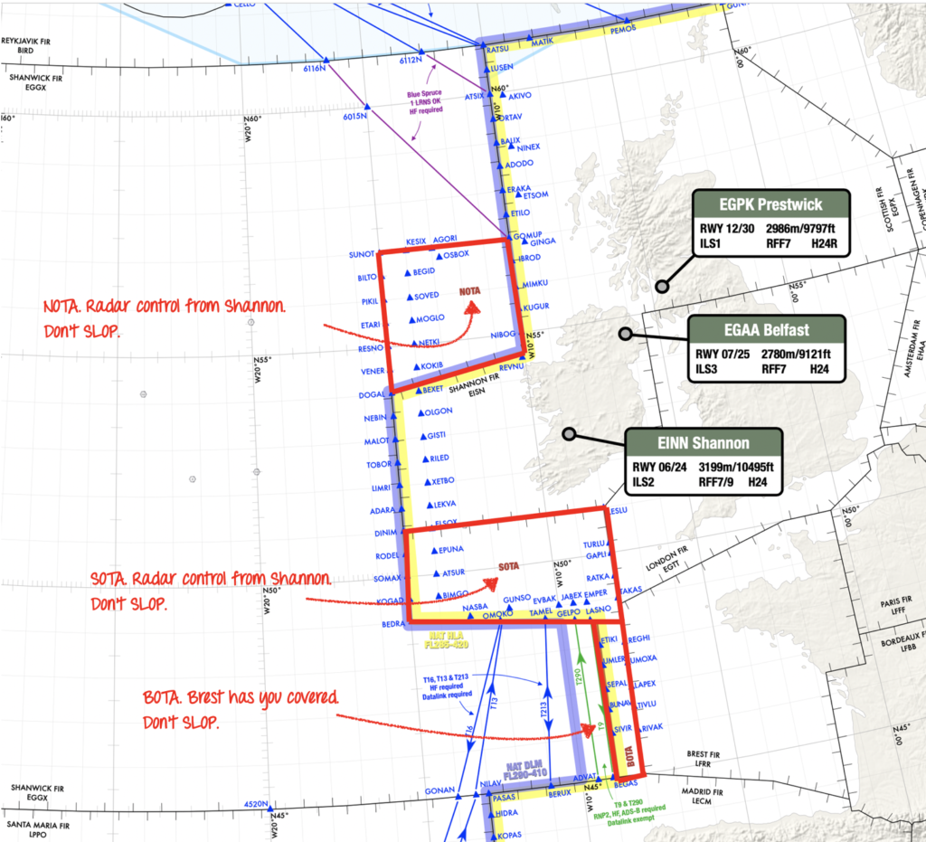
NOTA, SOTA and BOTA on the European side.
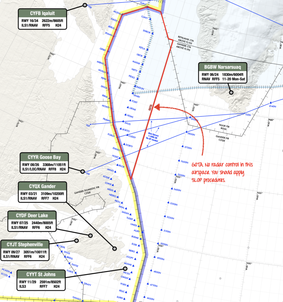
GOTA: Because there has to be an odd one out. This section of airspace is found off the coast of North-eastern Canada. Gander Center is responsible for separation here however there is no radar control. It is the only Oceanic Transition Area where you can and should SLOP.
 Are there any other ‘gotchas’?
Yes – three main ones:
- The ENOB/Bodo and BIRD/Reykjavik FIRs. Look out for these. Buried in the NAT Doc 007 it says that you are only allowed to SLOP above FL285. So don’t get caught out in the lower levels.
- Tango Routes T9 and T290. These lie just outside of BOTA airspace. According to the UK AIP ENR 3.5, SLOP does not apply here.
- And whatever you do – never SLOP left!
What’s the difference between the NAT Region and the NAT HLA?
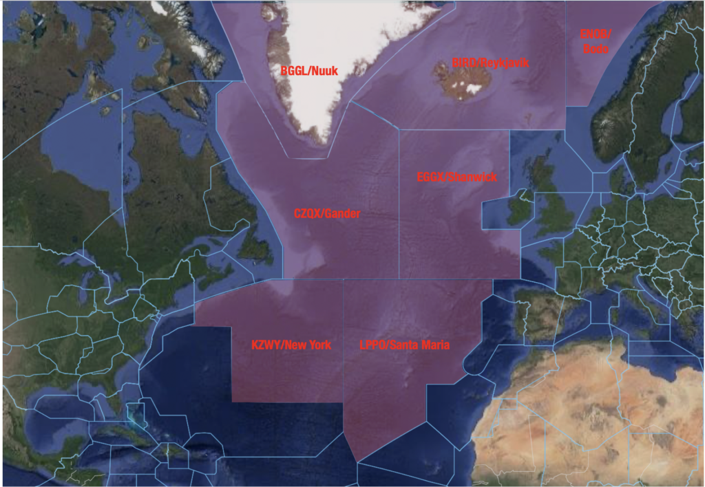
The NAT Region is virtually all of the non-domestic airspace over the Atlantic – from around 20 degrees north all the way up to the pole (excluding New York Oceanic West). It contains seven Oceanic Control Areas – BGGL/Nuuk, BIRD/Reykjavik, ENOB/Bodo Oceanic, CZQX/Gander, EGGX/Shanwick, KZWY/New York Oceanic East and LPPO/Santa Maria.
Within the NAT region (and occupying a large amount of it) is the NAT HLA, which stands for High Level Airspace. It only exists from FL285 to FL420.
Because the NAT HLA is some of the busiest airspace in the world, there are a number of stringent navigation and communication requirements that you must meet to enter it. This includes being either RNP 4 or RNP 10 capable, having two independent long range navigation systems and in most cases, datalink. Operators also need state approval.
If you don’t meant those requirements you can still fly through the NAT Region, but you’ll have to fly below or above the NAT HLA. Blue Spruce routes are the exception, which allow aircraft with only one long range navigation system or limited comms equipment to enter.
Nat HLA Airspace (Flight Level 285 – 420)
Can I fly across the North Atlantic without Datalink?
Yes, but it’s gonna be tricky.
The North Atlantic Datalink Mandate (NAT DLM) means aircraft need to have CPDLC and ADS-C to operate between FL290-FL410 throughout the NAT Region.
There are a few exceptions where the NAT DLM does not apply:
– Everything north of 80°North.
– New York Oceanic East FIR.
– Tango Routes T9 and T290. The other Tango Routes (T213, T13, T16) all require datalink.
– ATS Surveillance airspace, where surveillance service is provided by means of radar and/or ADS-B, coupled with VHF.
That last one about “ATS Surveillance airspace” is essentially just a section of airspace over Greenland and Iceland, which looks like this:
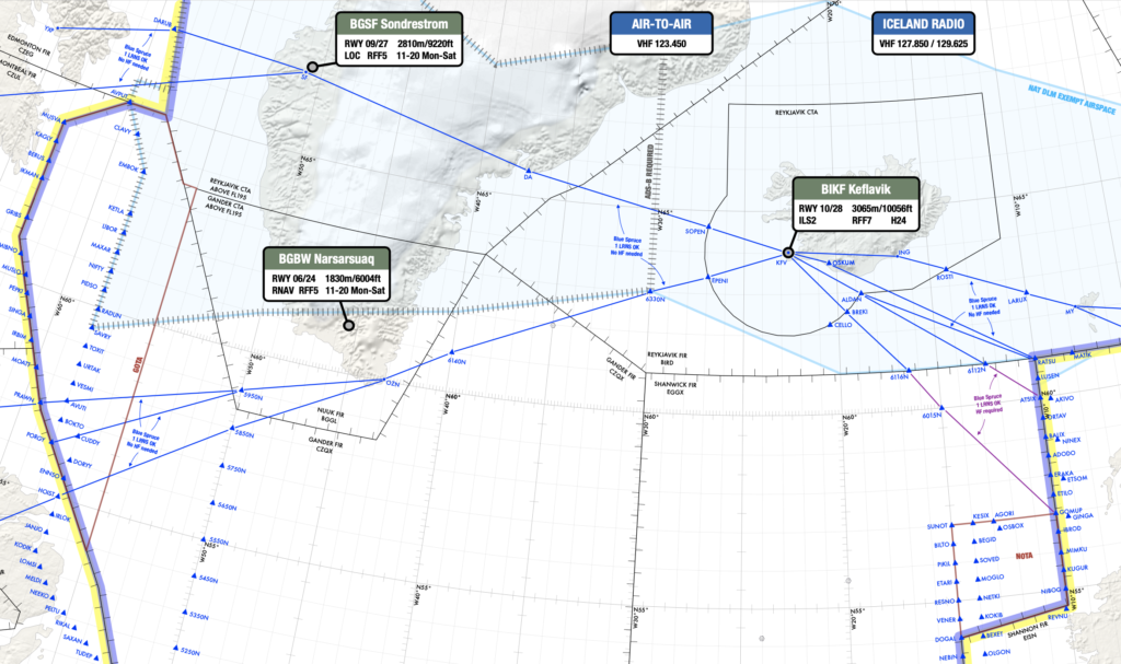
The blue shaded area shows the datalink exempt “ATS surveillance” airspace.
So if you’re on a NAT crossing and you don’t have datalink, you technically have to stay below FL290 until you hit the blue shaded area. It’s worth noting that aircraft without datalink can request to climb/descend through datalink mandated airspace, but will only be considered on a “tactical basis” by ATC.
Further south, there is another section of “ATS Surveillance Airspace” in the area connecting the LPPC/Lisboa FIR (i.e. mainland Portugal) to Madeira and the Azores, which is also exempt from the NAT DLM:
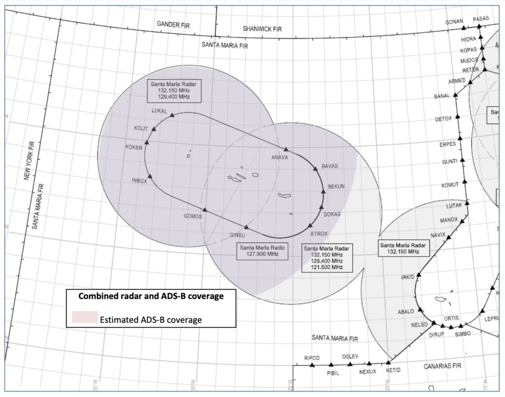
So in theory, an Atlantic crossing without datalink would also be possible here – within the LPPO/Santa Maria FIR you would just have to ensure that you stay below FL290 or above FL410 outside of the bubbles until you reach the KZWY/New York FIR (where the NAT DLM does not apply).
Even further south, in the TTZP/Piarco and GVSC/Sal FIRs, CPDLC is the primary means of communication, but it’s still not mandatory.
So down south, the bottom line is that as long as you stay out of the LPPO/Santa Maria FIR between FL290-410 where the NAT DLM applies… except for the ATS Surveillance Airspace bubbles where it doesn’t apply… then you’ll be ok with just HF. Got it? 😊
For more info on the NAT Datalink Mandate, check out our previous article.
So, what’s your conundrum?
We’d love to hear it. Chances are if you don’t know the answer, many other people won’t either, so it’s always great to share.
Get in touch with us at team@ops.group with your question, and we’ll include it in the next article on Naughty Nat Conundrums.
And if you want to download a PDF of our 2021 North Atlantic Plotting Chart, check how to get a copy here.

More on the topic:
- More: Oceanic Clearance Removal mess – delayed to December
- More: NAT FAQ: No HLA approval – Where can we go?
- More: NAT FAQ: No RVSM – Where can we go?
- More: NAT FAQ: No Datalink – Where can we go?
- More: NAT Clearance changes – a game!
More reading:
- Latest: Saudi Arabia Overflights – Free Route Gotcha
- Latest: International Ops Bulletin
- Latest: Outsmarting the GPS spoofers: A clever app
- Safe Airspace: Risk Database
- Weekly Ops Bulletin: Subscribe
- Membership plans: Why join OPSGROUP?


My challenge is to convince my colleagues to SLOP, even on random routes. It was very common pre-pandemic to encounter multiple aircraft crossing over or under us on our “random” route.
Most seem to think it only applies to NAT tracks.
I think the term random route is misleading. More like a non-OTS route. I’ve seen other aircraft on our same random route. I’ve had the same issues with other company pilots about SLOP. I tell them anytime we are in the NAT HLA we are expected to SLOP.
Hi Chris,
isn’t there a “ATS Surveillance airspace” also in a corridor/area connecting Portugal Mainland to Madeira and Azores? I believe there is a section with VHF and radar surveillance that exempts from datalink mandates in that section. Check page 7 of the following document:
https://www.icao.int/EURNAT/EUR%20and%20NAT%20Documents/NAT%20Documents/NAT%20Documents/Planning%20documents%20supporting%20separation%20reductions%20and%20other%20initiatives/LPPO_ImpPlan_Jan2015.pdf