Special Report: Russia transition to ICAO RVSM
Big Changes in Russia
Last month’s change by Russia and CIS States created the single biggest revision print in the history of Jeppesen – that’s quite an update! Here’s a summary of those changes and how it affects you on your next international flight crossing these countries.
Transition to ICAO “Vertical Separation System” and RVSM on 17th November, 2011.
This is a big, significant change, to flying in Russia and the CIS. The AIC’s issued by the member states are particularly vague and uninformative, so here’s some plain English explanations that will hopefully help understanding of the change. If you have more questions, just ask us …
Where?
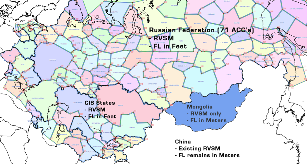
Russia
Mongolia
Kazakhstan
Kyrgyzstan
Tajikistan
Uzbekistan
Afghanistan.
What’s happening?
There are two things being brought in here –
1. RVSM, which is happening in all countries, and
2. Standard ICAO Flight Levels in feet, that we are used to in the rest of the world – which is happening everywhere except Mongolia.
When?
One minute past midnight, UTC, on the 17th of November, 2011.
RVSM
Standard meter separation at the moment is 600 meters above 8,900 meters. From Nov 17th, that will change to 300 meters – or 1,000 feet, up to FL410/FL411.
Flight Levels
At the moment, you’ll get a clearance from a Russian controller to “Climb Flight Level 8,900 meters”. You will jot this down, get out your conversion card, and run your finger down to 8,900 meters, to read off the Feet equivalent – FL 291. Dial 291 on the MCP, or fiddle with the FMS, and away you go.
After the change, your new clearance will be “Climb Flight Level 290”. No different to what you’re used to at home now.
What altitudes are affected?
Above the transition level, all levels will be FL, allocated in feet.
Below the transition level, altitudes will be in meters, for example, 1850 metres, 1500 metres, etc.. This is how things work in Belarus at the moment, for example, if you’ve ever been to Minsk.
Implementation
If you’re flying on the night of 16th November, here’s what you’ll hear.
2300Z “Attention all aircraft, RVSM Operations will begin in 1 hour
2340Z“Attention all aircraft, RVSM Operations will begin at 0001 UTC”
From 2300 only RVSM aircraft will be accepted in RVSM airspace (as opposed to sorting it all out at midnight Z)
Some exceptions:
AFGHANISTAN
A sign of the times – Afghanistan is implementing RVSM but is keeping three levels for military aircraft only. FL300 and FL310 will only be available to MIL aircraft, as will FL350.
MONGOLIA
Mongolia thought about it, but didn’t join in the change completely. They’re just doing RVSM, so the Meter allocation scheme will change to 300 meter instead of 600 meter separation, but that’s it.
ATC will issue the Flight Level clearance in meters. Pilots shall use the Mongolia RVSM FLAS Diagram (same as your existing China RVSM document) to determine the corresponding flight level in feet. The aircraft shall be flown using the flight level in FEET.
The request metric flight level within Mongolia RVSM airspace in Flight Plan shall be expressed as S followed by 4 figures (such as S1250, S1220 and S1190 represent 12500m, 12200m and 11900m respectively).
Eastbound Levels example
– ATC will say “KLM 802, Climb Flight Level 8,900 meters”
– Feet equivalent is FL 291 per your on-board conversion table
– Set FL 291 on your altimeter
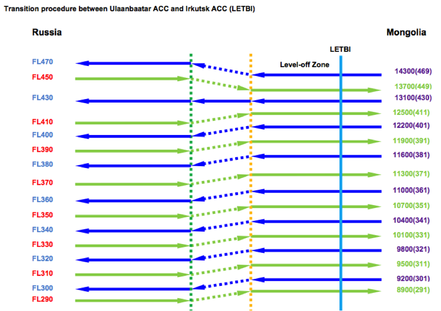
Transition Zone
Because Mongolia is working in Meters and Russia will now work in feet, there will be a small altitude adjustment near the ACC boundary.
Each ACC will have a different arrangement, some will do the transition on the Russian side and some on the Mongolian side – but each will have a “Level Off Zone” – 5 minutes of level flight, before or after which the climb/descent will take place.
Example 1
Let’s look briefly at position LETBI – the boundary between Ulaanbaatar ACC (Mongolia) and Irkustsk ACC (Russia). The transition zone here is on the Russian side.
An eastbound aircraft heading for Mongolia will be at FL370. Around 10 minutes prior to LETBI, the Russian controller will climb the aircraft to FL371 (11,300 meters) so that the aircraft is level at the new meter level for 5 minutes. Transfer of communications and control at LETBI will have the aircraft level at the correct meter level for Mongolia.
Example 2
A westbound aircraft along the same route, will maintain 11,600 meters (FL381). The Mongolian controllers will transfer comms and control at LETBI to the Russians.
“Irkustsk hello, KLM 801, maintaining Flight Level 11,600 meters”
“KLM 801, Irkustsk, roger, maintain present level”
5 minutes AFTER position LETBI:
“KLM 801, Irkustsk, descend Flight Level 360”